Understanding the
6-hourly international charts
Once you've
mastered the 3-hourly synoptic charts above, these are a doddle. They are
produced from the synoptic reports transmitted at the four
main standard hours (00, 06, 12 and 18 utc) using World Meteorological
Organisation standards and the WMO Global Telecommunications System.
The only
differences from the Australian 3-hourly charts are in the data I've
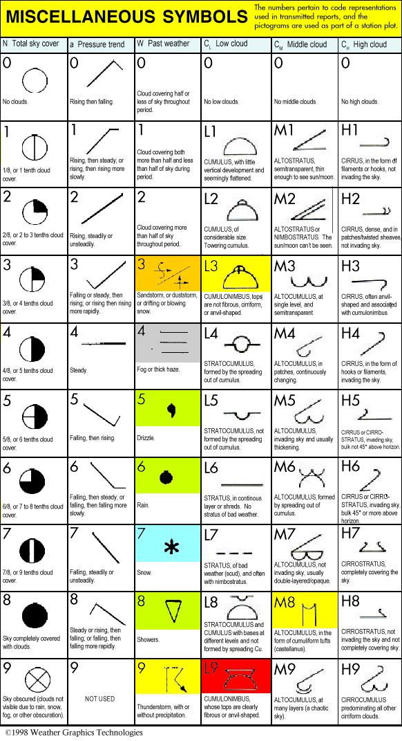
selected to put in the station plot. Some
cloud
information
has been
omitted
to
make
room
for maximum
and minimum temperatures for land stations and water temperature
and swell height for ships. So the station plot now looks like this:
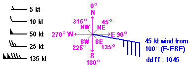
Tx
TT Tn PPP
RR ww + a pp
Td Cl
Sea temp Swell height
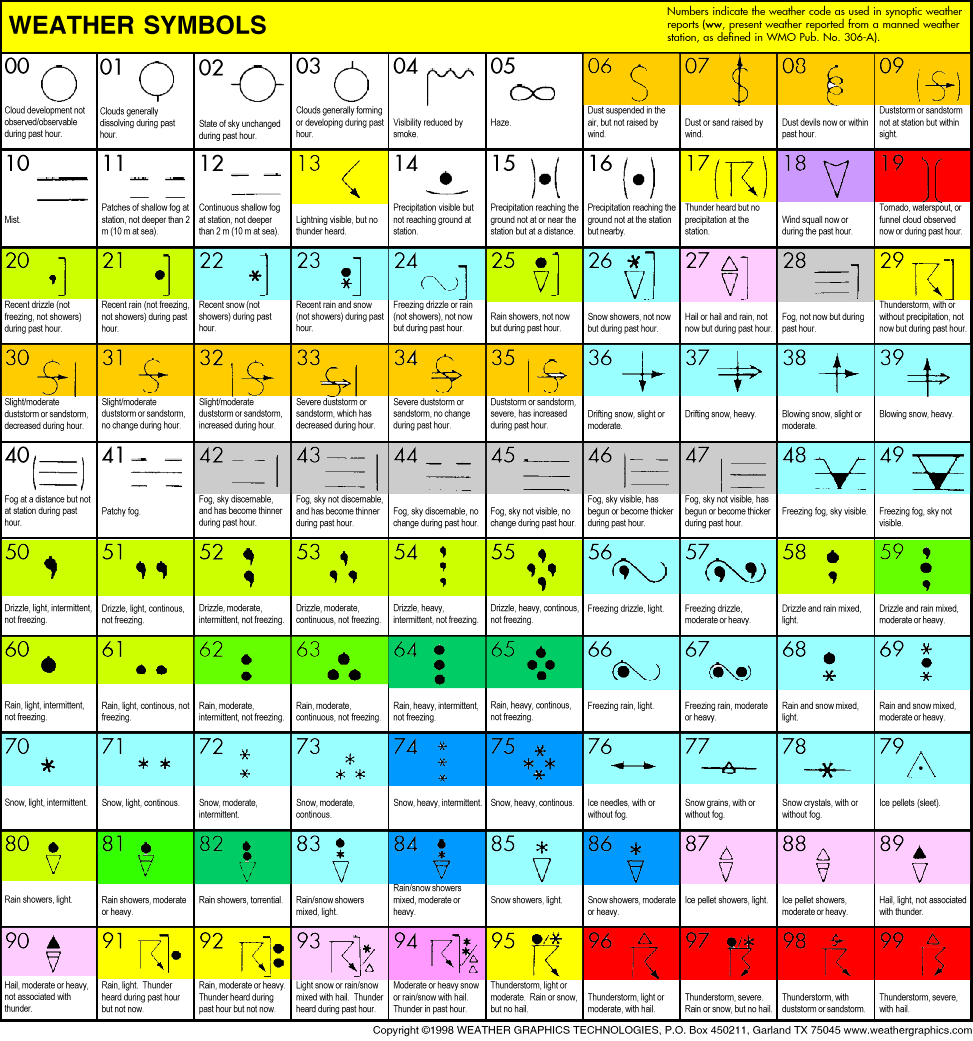
RR is reported for different periods on different continents -- check
the legend in the bottom left corner of the map for the period for each
map. Note that in South America standards vary from country to country,
and some countries don't report rain at all.
Maximum
(Tx) and minimum (Tn) temperatures are also a mixed
bag, sometimes reported, sometimes not, and varying in the time of
reporting
from
continent
to continent.
Sea
temperature and swell height are reported from some coastal stations and also from
some ships and drifting buoys, which make their first appearance on
these charts. Unlike Australian waters, which are pretty sparsely populated
by shipping, some sea areas such as the North Atlantic can boast more
ship reports than parts of Australia, Africa and South America. Sea
temp is in °C, and swell height is in metres.
Understanding
the upper air charts (temporarily
suspended)
The charts
show the pressure, temperature, humidity and wind at 7 standard levels
in the atmosphere. They are drawn from the measurements made by weather
balloons released from major airports around Australia twice daily,
at 9am and 9pm. The balloons measure barometric pressure, temperature
and humidity as they rise, and silver reflectors on them are tracked
by radar so as to determine wind direction and speed from the way the
balloons drift.
The levels
are stated in pressure (hPa or hectopascals) rather than in physical
height, as determining your precise height above the ground in a balloon
is not so easy. However, the pressure levels (or surfaces) roughly
correspond to the followiong altitudes, give or take a bit depending
on the temperature of the air:
925hPa =
about 900m
850hPa = about 1.5km
700hPa = about 3km
500hPa = about 5.75km
400hPa = about 7.5km
300hPa = about 9.5km
250hPa = about 10.5km
Once above
the ground, temperature, humidity, pressure and wind don't vary as
much over small distances as they do in the bottom kilometre or so
of the atmosphere. That is why quite reliable upper air charts can
be drawn with only a few dozen observations. The actual observations
at each level are plotted in a similar way to all the other charts:
TT HHH
+
TdD
But there
are some differences:
TT is temperature
in °C as usual
TdD is the
dew point depression. So if the plot showed a temperature of 10 and
a TdD of 15, the dew point would be -5. This makes it easier to see
dry and moist areas.
HHH is
the geopotential height of the pressure surface above sea level at
this
point. This is usually close to the geometric height, or altitude.
At the
925hPa
level,
the figures in this position are the number of (geopotential) metres
above sea level. At 850 and 700hPa, the thousands digits
are dropped off, and you need to add 1000 to the 850hPa level and 3000
to the 700hPa level; so,
for example, if the plotted height on a 700hPa chart is given as "154",
you can work out that it means 3.154km. At 500hPa the units digit is
dropped off, so 565 = 5,650km.
Wind is
shown by the usual wind arrows, but watch out for the 50 knot barbs
at higher levels, where wind speeds often exceed 150 knots.
The upper
charts put the essential third dimension into understanding the weather.
I find the best way to build an understanding in my head of what's
going on is to open a number of charts in different windows, make sure
they are aligned, then click between them. Be sure you have a surface
map handy or in your head, too. The temperature and pressure surface
height charts only go up to 500hPa, as these measures
are of
little importance in understanding weather developments at higher levels.
The humidity and wind charts go right up to 250hPa, as it is in the
upper levels that jet streams make their appearance and the presence
of humidity at high levels is an indication of deep moisture through
the atmosphere.
Contours
are given for:
Geopotential
height: Although
these black contours are lines of equal height above sea level, they
still produce the familiar high and low pressure systems, and winds
flow
roughly
parallel with the contours. The closer together the lines, the higher
the wind is likely to be. Look for upper closed low pressure systems,
upper troughs, and check whether they align vertically. The height
labels on the contours follow the same procedures described in HHH
above.
Temperature: The
red isotherms are one of the most vital signs of what is going on broadscale.
Watch for tongues of cold air pushing up from the south and warm air
pushing down from the north, especially on the 850, 700 and 500 charts.
Wind: Use
the wind barbs at stations to get an idea of wind directions. Then
use the isotachs, or lines of equal wind speed, to see where the strongest
winds are. The jet stream usually lurks above 500hPa, and a check of
the 400, 300 and 250hPa charts will usually find it. Or them, because
there are usually a number of jets snaking across the Australian chart.
Look for areas where the wind speed is accelerating into a jet, as
these are commonly areas where bad weather develops.
Relative
humidity: The
green dotted contours show relative humidity. Although the humidity
is analysed at 10% intervals, they are only important in giving a
broad idea of where the main areas of moist and dry air are. Watch
the areas of >70% humidity, and in particular >90% at the 500 and
700hPa levels, and see which way the wind is advecting them.
|