Year 2000 temperatures go against the trend
Significant rainfall records broken for December in Qld/NT
 |
| Annual rainfall deciles for year 2000. A decile is a 10% range, so annual totals in decile 10 are those that are in the top 10% of measurements on record. BoM |
A notable record was set on the summit of Bellenden Ker which recorded the highest annual rainfall total ever measured in Australia. The mountain summit, southwest of Cairns and 1555 metres above sea level, recorded 12,461mm of rain in 2000, breaking its own 1999 record of 11,852mm by 609mm. 1050mm fell in three days at the end of February during the passage of Tropical Cyclone Steve, though the wettest day was 6 December when 468mm fell.
The map above (click for a large copy) shows that most of the northwestern half of the continent experienced annual totals in the top 10% of all recordings, while totals in parts of WA, NT and Qld were the highest on record. Capital city residents, however, are unlikely to have noticed, with most capitals recording average or below average rainfall. Southeast Queensland, including Brisbane, experienced record or close to record low rainfall for the year. Among the locations to report their driest years on record are Brisbane Airport with 574mm (only half its annual average), Amberley 390, Boonah 360 and, on the Darling Downs, Tara with 234mm.
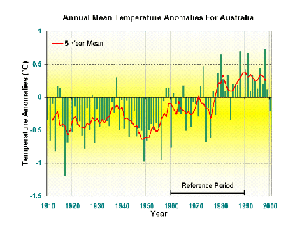 |
| The Australian average annual mean temperature is calculated from 127 non-urban observing stations across Australia. The temperature records at these sites have been adjusted for changes due to instrumentation and location. Many of the sites are included in Australia's Reference Climate Station network - a special network established to monitor long-term climate trends and variability. BoM |
The wet conditions and greater than normal cloud cover resulted in the average temperature for the country as a whole being 0.22° below the 1961 to 1990 average, the first time since 1984 that the Australian mean annual temperature has been below average. The mean maximum temperature was the main cause of the anomaly, being 0.44° below normal, while the mean minimum temperature was close to normal.
While 2000 was cool, the graph at left shows that most of Australia's warmest years on record occurred during the 1980s and 1990s. Global mean temperatures have also risen over the past century. According to preliminary estimates released by the World Meteorological Organization on 19 December 2000, the global mean temperature for 2000 was the fifth warmest on record, with Australia being one of the few regions recording a cooler than average year.
Some significant monthly rainfall records
were broken in the Northern Territory and Queensland for
December. In the following table, the first figure is December 2000 rainfall,
second figure is previous record, third figure is the number of years
of record at the station.
| Brunette Downs NT | 393.0 | 234.0 | 106 |
| Tennant Creek AP NT | 255.4 | 215.9 | 31 |
| Jervois NT | 288.0 | 195.2 | 35 |
| Lockhart River Qld | 966.3 | 825.7 | 44 |
| Burketown PO Qld | 907.2 | 534.0 | 110 |
| Mt Isa AP Qld | 270.4 | 169.2 | 34 |
| Longreach AP Qld | 193.4 | 136.2 | 46 |
| Camooweal Qld | 289.2 | 258.5 | 107 |
| Urandangie Qld | 362.2 | 271.0 | 109 |
| Boulia Qld | 259.1 | 221.0 | 115 |
| Willis Island Qld | 472.8 | 450.8 | 79 |
These figures haven't been quality controlled yet, but give some idea of the unusual rainfall in western Qld/eastern NT of the past few weeks. To have >100 year records fall over such a wide area is remarkable.