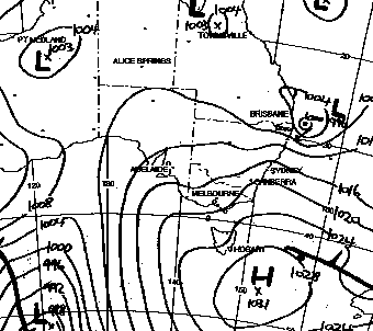
Australian Weather News


Thursday, 08 MAR 2001

About Australian Weather News
Gales, flood rains as cyclonic low crosses NSW North Coast
A Tasman Sea low, exhibiting every characteristic of a tropical cyclone apart from having a tropical origin, slammed into the NSW North Coast late this afternoon causing widespread wind damage and torrential rain, dramatically worsening an already tense flood situation. The depression formed in the northern Tasman Sea at around 30°S last Sunday morning, and has drifted slowly but steadily W to WNW since then.
The synoptic chart for 5pm EDST today (above, BOM) shows the small low shortly before it crossed the coast near Ballina.
The visible light satellite image (above right, CIMSS) for the same time shows a distinct eye. The wind arrows show wind direction and speed at a height of about 3km, with strong winds in the southwestern  quadrant. The infrared image for 9.30pm EDST (below right, NPMOC), shows an eye structure still in place, moving north of Ballina close to the coast.
The rapid rise of the Bellinger River (below, MHL) followed torrential overnight rain.

The low, with a distinct eye visible on satellite and radar images, crossed the coast near Ballina around 6pm, dropping the pressure at the airport to 992.5hPa. It then moved slowly north close to the coast before moving into SE Qld. Because it has been so slow moving, the low has had time to entrain copious amounts of warm, humid, tropical air down its eastern flank. This, coupled with strong divergence, or outflow, aloft and high vorticity, or rotation imparted by the surrounding atmosphere, at lower levels, has set the scene for a major east coast flood event.

Squally, galeforce winds reached cyclonic speeds, with Evans Head automatic weather station, 30km south of Ballina, recording a top gust of 139km/h at 5.15pm. Around 100 buildings at Yamba, 60km south of Ballina, were damaged, and State Emergency Services attended 350 calls for roof damage and downed trees in the North Coast area. Large trees were snapped off or uprooted near the coast, where the winds were strongest, and 70 power lines were cut, blacking out over 10,000 homes between Kempsey and Ballina. SES advised against all non-essential road travel in the Lismore area because of the extensive storm damage, and the severe winds made travel and work close to impossible for repair crews. Caravan parks were evacuated because of the threat of caravans being overturned, and one man was injured by a falling tree.

Rain generated by the low intensified overnight along 500km of the NSW Mid North and North Coasts stretching from the northern Hunter Valley to Byron Bay. Warnings ranging from minor to major flooding were issued for all rivers from the Paterson River north of Newcastle to the Richmond River near Lismore as heavy rain fell throughout the day and was forecast to continue.

The heaviest falls were in the ranges behind Coffs Harbour, where Dorrigo registered over 500mm in the two days ended 9am Friday (see AWN for 9 March for an analysis of rainfall in this event). This resulted in a dramatic rise in the Bellinger River to its highest levels in over 20 years, prompting declaration of the Bellingen Shire as a disaster area. The town, and the upstream community of Thora, were isolated. The neighbouring communities of Darkwood and Kalang have been isolated for 3 days, and the upper Bellinger valley has no power. Helicopters began making food drops this afternoon.

Elsewhere on the coast

  • Bridges and roads were cut by floodwaters, landslides and downed trees, with the main Pacific Highway reduced to one lane north of Taree and north of Coffs Harbour
  • Two men were rescued from a car washed into a creek in Kempsey
  • Coffs Harbour residents sandbagged homes and businesses against local flooding, while SES workers were sandbagging the main street of Ballina in anticipation of high tides banking up the flooded Richmond River
  • Heavy seas pounded the North Coast, causing beach erosion.

National weather extremes for today
Data provided by the Bureau of Meteorology
Last updated at 20:11 EDST on 11/03/01

Quality control note: Data is complete, and has been visually checked by AWN for gross errors. Less obvious errors may remain. See Explanation of Extremes Pages for more information
Records set this day (previous record and years of computerised record shown in brackets):
Highest maximum temperature for March:
Double Island Point Lighthouse Qld: 33.7 (31.7,37)

Todays highest rainfall totals for the 24 hours to 9am. It includes the top 5 totals received, and/or all reported falls of 50mm or more.

179.0 DORRIGO (OLD CORAMBA RD) MidNorth Coast N NSW
176.0 DORRIGO POST OFFICE MidNorth Coast N NSW
166.0 BELLINGEN HYDE STREET MidNorth Coast N NSW
120.6 MELDRUM MidNorth Coast N NSW
114.0 BOWRA SUGARLOAF MidNorth Coast N NSW

WESTERN AUSTRALIA
    Gt Southern
56.0 CRANHAM

NORTHERN TERRITORY
    Arnhem
66.0 MILINGIMBI
62.0 RAMINGINING

QUEENSLAND
    N Peninsula
109.0 COCONUT ISLAND
96.0 WEIPA AERO
92.0 CAPE KEERWEER
53.4 BAMAGA
    S Peninsula
60.3 LOCKHART RIVER AIRPORT
    Brisbane/SE Coast
53.6 SPRINGBROOK TM

NEW SOUTH WALES
    N Tablelands E
74.8 POINT LOOKOUT
    North Coast
85.2 NIMBIN POST OFFICE
83.8 LISMORE (CENTRE STREET)
79.8 LILLIAN ROCK (WILLIAMS ROAD)
79.0 NIMBIN (GOOLMANGAR CREEK)
75.0 THE CHANNON
68.0 MULLUMBIMBY (FAIRVIEW FARM)
57.0 ROCK VALLEY (LEYCESTER CREEK)
52.4 TWEED HEADS GOLF CLUB
51.0 TUNCESTER (LEYCESTER CREEK)
    MidNorth Coast N
179.0 DORRIGO (OLD CORAMBA RD)
176.0 DORRIGO POST OFFICE
166.0 BELLINGEN HYDE STREET
120.6 MELDRUM
114.0 BOWRA SUGARLOAF
112.0 LOWANNA (CAVANAGHS ROAD)
108.5 THORA POST OFFICE
73.0 GIRRALONG
58.0 MILLBANK (FAIRLIE DOWNS)
52.0 BOWRAVILLE COHALAN ST
50.8 COFFS HARBOUR MO
    MidNorth Coast S
85.4 ELANDS (BLACK SANDS CREEK)
78.0 BULAHDELAH POST OFFICE
69.6 YARRAS (MOUNT SEAVIEW)
69.0 COMBOYNE POST OFFICE
64.0 UPPER PAPPINBARRA (HILLCREST)
61.6 ROCKS CROSSING (NOWENDOC RIVER)
54.0 UPPER ROLLANDS PLAINS (GREENACRES)
    Hunter Valley
84.4 UPPER ALLYN TOWNSHIP
73.0 UPPER CHICHESTER (SIMMONDS)
57.0 DUNGOG POST OFFICE
56.0 GRESFORD POST OFFICE
50.0 LOSTOCK DAM SITE
    Sydney--east
50.2 AVALON BEACH GEORGE ST

High rainfall for periods of 6 hours or less.


NORTHERN TERRITORY
    Arnhem
MILINGIMBI
22.8mm in 20 min to 01:30 68.4mm/h
28.0mm in 1 hr to 01:30 28.0mm/h
16.8mm in 30 min to 02:00 33.6mm/h
44.6mm in 1 hr to 02:00 44.6mm/h
47.0mm in 3 hr to 02:30 15.7mm/h
GOVE AIRPORT
24.2mm in 22 min to 13:52 66.0mm/h
32.8mm in 1 hr to 14:30 32.8mm/h
33.0mm in 3 hr to 14:30 11.0mm/h
    Victoria
LAJAMANU
20.2mm in 1 hr to 15:30 20.2mm/h

QUEENSLAND
    N Peninsula
COCONUT ISLAND
73.0mm in 3 hr to 03:00 24.3mm/h
85.0mm in 6 hr to 03:00 14.2mm/h
HORN ISLAND
12.2mm in 1 hr 11 min to 18:00 10.3mm/h
32.0mm in 3 hr to 18:00 10.7mm/h
    Brisbane/SE Coast
COOLANGATTA AIRPORT
1.8mm in 1 min to 10:25 108.0mm/h
4.8mm in 11 min to 16:11 26.2mm/h

NEW SOUTH WALES
    North Coast
YAMBA PILOT STATION
32.0mm in 3 hr to 18:00 10.7mm/h
BALLINA AIRPORT AWS
22.8mm in 1 hr 57 min to 15:00 11.7mm/h
CASINO AIRPORT AWS
31.2mm in 1 hr 58 min to 14:58 15.9mm/h
35.0mm in 3 hr to 15:00 11.7mm/h
11.8mm in 25 min to 18:32 28.3mm/h
45.0mm in 3 hr to 21:00 15.0mm/h
EVANS HEAD RAAF BOMBING RANGE
20.4mm in 45 min to 18:00 27.2mm/h
22.6mm in 1 hr to 18:00 22.6mm/h
51.0mm in 3 hr to 18:00 17.0mm/h
21.0mm in 1 hr 26 min to 20:35 14.7mm/h
31.0mm in 3 hr to 21:00 10.3mm/h
82.0mm in 6 hr to 21:00 13.7mm/h
13.6mm in 25 min to 22:00 32.6mm/h
5.0mm in 7 min to 22:07 42.9mm/h
    MidNorth Coast N
KEMPSEY AIRPORT AWS
21.2mm in 1 hr to 10:00 21.2mm/h
35.0mm in 3 hr to 12:00 11.7mm/h
COFFS HARBOUR MO
8.4mm in 17 min to 08:46 29.6mm/h
5.4mm in 8 min to 10:38 40.5mm/h
5.0mm in 11 min to 16:02 27.3mm/h
DORRIGO (OLD CORAMBA RD)
79.0mm in 6 hr to 15:00 13.2mm/h
    MidNorth Coast S
PORT MACQUARIE AIRPORT AWS
16.4mm in 33 min to 10:00 29.8mm/h

TASMANIA
    N Coast
SHEFFIELD SCHOOL FARM
30.0mm in 3 hr to 06:00 10.0mm/h

Todays highest & lowest temperatures

Maximum Minimum
40.0 NULLARBOR ROADHOUSE W Agricultural SA
39.0 EUCLA Eucla WA
39.0 CEDUNA AMO W Agricultural SA
38.8 URANDANGIE Northwest QLD
38.5 MARBLE BAR COMPARISON E Pilbara WA
28.0 MCCLUER ISLAND Darwin-Daly NT
28.0 DUM IN MIRRIE Darwin-Daly NT
28.0 CAPE FOURCROY Islands ISL
27.7 BIDYADANGA W Kimberley WA
27.5 BLACK POINT Darwin-Daly NT
9.3 MOUNT WELLINGTON Southeast TAS
12.8 HARTZ MOUNTAIN(KEOGHS PIMPLE) Southeast TAS
14.3 LAKE LEAKE (ELIZABETH RIVER) E Coast TAS
14.3 BARREN TIER Central Plateau TAS
15.0 THREDBO (CRACKENBACK STATION) AWS Snowy Mtns NSW
-0.2 CHARLOTTE PASS (KOSCIUSKO CHALET) Snowy Mtns NSW
1.0 PERISHER VALLEY SKI CENTRE Snowy Mtns NSW
2.8 THREDBO VILLAGE Snowy Mtns NSW
3.0 THREDBO (CRACKENBACK STATION) AWS Snowy Mtns NSW

Todays greatest temperature variations from normal

Maximum Minimum
+14.0   39.0 EUCLA Eucla WA
+13.7   37.7 ELLISTON W Agricultural SA
+13.0   40.0 NULLARBOR ROADHOUSE W Agricultural SA
+12.4   39.0 CEDUNA AMO W Agricultural SA
+11.4   36.4 WAROOKA Yorke Peninsula SA
+8.4   22.0 TOCUMWAL AIRPORT Riverina E NSW
+8.0   21.6 CAPE BORDA Kangaroo Is SA
+7.5   21.8 ELLISTON W Agricultural SA
+7.3   22.0 STREAKY BAY W Agricultural SA
+7.2   18.0 LONGERENONG Wimmera S VIC
-7.0   19.5 RAVENSTHORPE Gt Southern WA
-6.7   25.0 BADGINGARRA RESEARCH STN Lower West WA
-6.3   26.9 ENEABBA Central West WA
-5.1   28.5 MULLEWA Central West WA
-5.0   27.6 CARNAMAH Central West WA
-5.0   23.3 GRAFTON OLYMPIC POOL North Coast NSW
-4.9   18.0 LEARMONTH AIRPORT W Pilbara WA
-4.9   13.6 KAIRI RESEARCH STATION N Coast--Barron QLD
-4.1   3.7 OMEO Upper NE VIC
-3.9   15.6 WALKAMIN DPI N Coast--Barron QLD
-3.9   18.0 SOUTH JOHNSTONE EXP STN N Coast--Herbert QLD

Highest wind gusts above 89km/h or mean wind above 62km/h (gale force). Wind direction and mean windspeed shown in brackets.

CASINO AIRPORT AWS North Coast NSW: 93 (210/ 54 ) at 20:00
EVANS HEAD RAAF BOMBING RANGE North Coast NSW: 139 (170/100 ) at 17:15

Other extremes

..