Flash flooding caused mayhem to traffic from the northern to western suburbs of Melbourne. Tullamarine Freeway, linking the city to the airport, was worst hit, with up to 2 metres of water in places bringing traffic to a standstill. The Age reported that one taxi driver clocked up $146 for two Sydneysiders he picked up in the city that took 2½ hours to reach the airport. The SES received over 300 calls for help, mostly in Broadmeadows, Laverton, Tullamarine, Footscray and Keilor. Parts of the West Gate Freeway and northern ring road were flooded, and Yarra Trams and Bayside Trains both cancelled services. The Titanic Theatre Restaurant in Williamtown suffered $60,000 damage, but got invaluable publicity, when water rushed through its doors. Flooding would probably have been worse if the ground around Melbourne had not been so parched from extended drought conditions over summer.
While there has not been time for a full analysis of the causes of this event, it has a number of peculiar and interesting features. No thunder was reported, cold upper air and its attendant surface low had moved away to the east overnight, the Melbourne Airport balloon ascent at 9am showed a conditionally stable (if very moist) atmosphere with an inversion at about 3,000 metres, CAPE, a measure of available energy, was a low 32, low level vorticity was modest and upper level divergence was negative. Most of the atmospheric accompaniments one would expect with such an event were missing. So why did it happen?
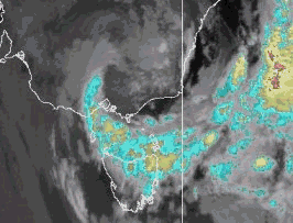 |
| Hourly IR satellite images from 3.30am to 2.30pm show the cloudband wrapping around the main low circulation, centred off the East Gippsland coast. A westward extension of the circulation, possibly the development of a transient low, appears to occur just east of Melbourne around 9.30 to 10.30am. The colour enhancement gives an indication of cloud depth, with the coldest cloud tops (highest clouds) graded blue to orange. NPMOC |
The satellite animation (right) shows a nearly stationary circulation off the East Gippsland coast from early morning to mid-afternoon, with a broad tongue of deep cloud curling underneath it. The cloud is some 5 or 6° warmer in the lower levels than the mostly clear air over eastern Victoria, where a cold pool is sitting to the north of the circulation. Between 10pm last night and 7 this morning, a narrow band of moderate to heavy rain persisted through the eastern Otways, Geelong and for about 100km to the north. Geelong Airport recorded 60.6mm during this time, for a 24-hour total of 62.4mm. This is unusually heavy rain for the area -- Geelong Norlane's highest March 24-hour rainfall in 30 years' observation is 58.4mm.
Radar shows the rain area easing between 7 and 9am, but spreading over most of the area between Geelong and the Dandenongs, and northwards into central northern Victoria. Shortly after 9am, an observer in Leopold, an eastern suburb of Geelong, noted a rapid increase in temperature from 11.4 to 17.1° in about 2 minutes; Geelong Airport's recording was not so sharp, but both the temperature and dew point rose 5° between 7 and 9am while the wind turned fresh southwesterly. This warm humid southwesterly persisted at Geelong for the rest of the day.
Both Melbourne and Laverton Airports, to the ENE of Geelong, however, experienced moderate north to northeasterly winds and temperatures around 5° lower than Geelong's until between 1 and 2pm, when the temperatures rose and winds turned southwesterly. It seems clear that a local convergence zone developed around mid-morning to the east of Geelong, with warm moist air -- the "returning" tropical moisture that had fed around the southern side of the low -- feeding the zone from the southwest. Around this time, the circulation shown on the satellite loop also deforms westward, while a SW/NE blue (cold-topped) cloud band develops along the convergence line which lies approximately Laverton to Melbourne Airport to Kilmore Gap, about 100km north of Melbourne.
|
3-hourly rainfall totals |
||||||
| Geelong AP | Laverton AP | Melbourne AP | Kilmore Gap | Melbourne City | Dunns Hill (Mt Dandenong) | |
| Midnight to 3am | 12.6 | 0.2 | 0.0 | 0.0 | 0.0 | 0.0 |
| 3am to 6am | 22.6 | 3.4 | 1.6 | 0.0 | 0.2 | 0.0 |
| 6am to 9am | 17.0 | 10.8 | 8.0 | 5.8 | 3.4 | 2.8 |
| 9am to noon | 4.2 | 46.2 | 51.8 | 40.8 | 28.4 | 4.8 |
| noon to 3pm | 1.2 | 45.0 | 47.0 | 29.8 | 13.4 | 0.0 |
| 3pm to 6pm | 0.0 | 0.6 | 0.2 | 9.6 | 2.4 | 17.0 |
| 6pm to 9pm | 0.0 | 0.0 | 0.0 | 0.0 | 0.2 | 13.2 (to 10pm) |
While rain eased off at Geelong after 7am, heavy rain did not begin at Laverton, Melbourne or Kilmore Gap until after 8am. Then the heavens opened. Melbourne Airport recorded 102.2mm between 8.40 and 2pm. Laverton AP received 96.8 between 8am and 2pm, while Kilmore Gap's period of heavy rain was from 8.30 to 4pm, yielding 80.0mm. Totals dropped off substantially away from the Laverton -- Kilmore Gap axis, though Melbourne City still managed a respectable 43.8mm between 9am and 3.30, when the rain stopped abruptly. Only a handful of rainfall stations exceeded 50mm (see National Extremes for 23 March).
The automatic weather stations at Laverton, Melbourne Airport and Kilmore Gap all show the rain stopping abruptly, around 2pm to the west of Melbourne and around 4pm to the north, as the convergence zone that supported the area of heavy rain was driven NE by strengthening southwesterlies and dissipated. As this second rain phenomenon finished, a third but relatively insignificant rain event began in the Dandenongs, with over 30mm recorded at Dunns Hill between 3 and 10pm. The cloudmass that produced this event can be seen approaching the area in the last two frames of the satellite loop above.
As a final touch to an unusual two days of weather in the southeast, powder hounds were salivating at the prospects for an early winter as a light dusting of snow was reported from the peaks of the Victorian Alps and from Perisher Valley during the day.
Central Australia continued to shiver, with daytime temperatures again just making it into the mid-teens. Curtin Springs, which set a new March record low maximum for the NT of 14.4 yesterday, only reached 14.5 today, 19.3 below the long term March average. Giles and Alice Springs were both 16 or 17 below normal. Over the border in southwestern Queensland, Thargomindah recorded its lowest March minimum in 43 years of computer records when the mercury dropped to 9.6.