 |
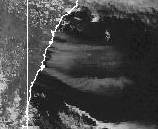
| Plumes of smoke from the Sydney Christmas Day fires stream 500km into the Tasman in this visible satellite imagery captured at 3.30pm today. NPMOC |
At Lapstone, the Highway and main railway line, which reopened this morning after yesterday's fires, were again closed as a major blaze moved ESE and jumped the Nepean River. The worst-hit centres were around Glenmore Park south of Penrith, Silverdale and Warragamba. Initial estimates put 22 houses in the Penrith area destroyed. Spot fires developed away from the firefront, resulting in progressive road closures including the M4 motorway. Shops were ablaze in Warragamba village, and a factory was destroyed near St Marys. About 5,000 people were isolated in Warragamba and Silverdale when fires cut access to the settlements. In the lower Blue Mountains, fires continued to threaten, causing the evacuation of homes near Blaxland, Lapstone, Glenbrook, Windsor and along Blaxland's Ridge near Kurrajong. 7,000 homes in the lower Mountains had no power or water. Many of the evacuations came as families were sitting down to Christmas Lunch.
By late evening, the firefront was continuing to move ESE towards the southern Sydney suburbs of Engadine and Campbelltown, and the northern Wollongong settlements of Helensburgh and Otford. Dozens of people were forced to flee the community of Darkes Forest, south of Helensburgh, in the worst fires in that region for 35 years.
Elsewhere in NSW, an increasingly grim bushfire picture emerged, with 70 fires burning out of control in the dry, gusty winds.
- Fires in the Shoalhaven south of Nowra severely damaged or burnt down up to 20 properties in the area around Tomerong and Huskisson. The fire burnt through parts of Vincentia and Tomerong and was heading towards Callala Beach late today. Princes Highway was closed south of Nowra. Power cuts extended from Huskisson down the coast as far as Moruya.
- North of Wollongong, homes
were evacuated at Stanwell Tops, Otford, Waterfall,
Helensburgh, and the Garrawarra Nursing Home south of Waterfall after the lower Blue Mountains fire front travelled 60km in an unprecedented six hours. Many were taken to the Wollongong Entertainment Centre, which was accommodating about 1100 people at days end. The evacuations included many holiday makers from Royal National Park who had nowhere else to go. Hundreds of these were people who were originally evacuated to Helensburgh and had to be re-evacuated. However, attempts to move them north to Engadine failed, and they were eventually taken to Wollongong. More than 3,000 campers in all were evacuated from RNP. All major roads including the F6, old Princes Highway, Appin Road, Sir Lawrence Hargrave Drive and Bulli Pass were closed, and south coast trains were suspended between Sutherland and Thirroul. The M5 was closed south of Narellan. Power was lost at many coastal towns, either through power poles burning down, or the need to remove power for the protection of firefighters and the public. - In the ACT, fire crews continued to battle blazes on the slopes of Red Hill in Canberra's south, and on the ACT/NSW border near Queanbeyan. One house was burnt down. Fresh fires broke out at Mt Wanniassa in Macarthur, Yarralumla and Belconnen and spot fires were reported in O'Connor, Queanbeyan and Curtin.
- On the North and Mid North Coasts, two homes were destroyed at Corindi, 30km north of Coffs Harbour, though valiant efforts by firefighters saved the villages of Billynudgel north of Byron Bay, Tullymorgan NE of Grafton and Arakoon NE of Kempsey. The Pacific Highway was closed south of Grafton and near Kempsey where large fires were moving into the Bunjelung and Hat Head National Parks.
- In the Hawkesbury area north of Sydney, 14 homes were lost to fire.
- A major fire was also reported from Narromine in the state's central west.
At a press conference at day's end, Rural
Fire Services Commissioner Phil Koperberg said that today's emergency
was the most intense he had seen. An estimated 60 homes, factories and
shops were destroyed during the day. Describing how winds of 100km/h created
terrifying firestorms up to 30 metres high, the commissioner said the
emphasis now was on saving lives and property. "We estimate we have some
4,000 people from all the services in the field attempting not to put
out the fires, that's impossible at the moment," he said. "They have saved
literally hundreds and hundreds of houses in door to door firefighting
in the past 12 hours. Then tomorrow we face the daunting prospect of strong
south westerly winds which means that everything that is a flank today
becomes a front tomorrow."
While maximum temperature records fell in northern NSW and SE Qld, Christmas brought wintry weather to Tasmania and parts of Victoria. Byron Bay on the NSW North Coast recorded its all time highest maximum temperature in 24 years of computerised records when the mercury rose to 35.1. In Queensland, Baralaba, 100km SW of Rockhampton, recorded its hottest December day in 32 years with a top of 43.4. Like yesterday, maximum temperatures were between 8 and 14° above average along the NSW coast north from the Illawarra and through much of SE Qld.
The strong hot westerlies that caused bushfire grief in NSW were strong cold westerlies across Tasmania and southern Victoria. The temperature difference between Hobart and Sydney at the 850hPa level in the atmosphere (about 1.3km) was around 17° (1° over Hobart, 18 over Sydney), explaining the intensity and breadth of the westerly airstream. On the summit of Mt Wellington behind Hobart, the temperature hovered between 1 and 3° for most of the day, with strong winds peaking at 117km/h at 7pm and light snow flurries during the afternoon and evening. Wintry showers, with hail and occasional thunder, were reported from Tasmania and coastal Victoria. A deep low pressure system south of Tasmania was responsible, with the observer at Maatsuyker Island, off Tasmania's south coast, noting that the 3pm pressure reading of 980.5hPa was the lowest 3pm pressure reading so far this year.