![]() A
hot end to winter in central eastern Australia
A
hot end to winter in central eastern Australia
|
DROUGHTWATCH
|
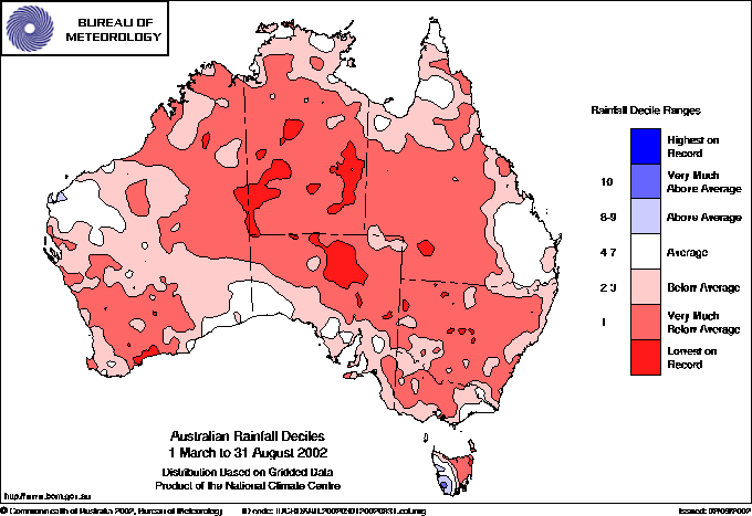
| Rainfall deficiencies for the 6 months of Autumn and Winter show up in this rainfall decile map from the Bureau of Meteorology. Very much below average rainfall, defined as falls in the lowest 10% of all recordings, cover most of the continent. |
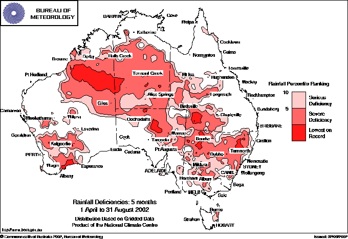 |
The rainfall deficiency map shows areas with serious and severe deficiencies over the 5 months April to August. Serious deficiency (pink) means rainfall totals in the lowest 10% of historical totals over the past 100 years, while severe deficiency (light red) are falls in the lowest 5%. Dark red areas are the lowest recordings in the past century. BoM |
Drought grips large areas of southern Australia after an exceptionally dry autumn and winter across the country. The worst affected areas are NSW, northern and western Victoria, eastern SA, southwest WA and eastern Tasmania. In contrast, very much above average August rainfall gave some relief to southeast Queensland.
The Bureau of Meteorology's Drought Statement issued 3 September 2002 says that "for the five-month period from April to August, serious to severe rainfall deficiencies have developed across a vast sweep of country extending from northwest WA across the NT and northern SA to western Queensland and further southward across most of NSW and the western half of Victoria. Eastern Tasmania and parts of the southwest of WA are also affected, the latter for the third successive year. However, the deficiencies in the tropical and central areas of Australia are not as significant as those further south on two counts; firstly the April to August period is largely in the seasonally dry time of year, and secondly much of this area experienced a wetter or very much wetter than average summer. Some of the areas near Tamworth and Bourke in NSW, and between Albany and Esperance in southern WA have recorded the driest April to August period in a record dating back to 1900. "
Other features of a dry winter include:
- August rainfall in Victoria was well below normal in all districts, with only a third of the average falling in the South Mallee, the Lower and Upper North, the Upper Northeast, and also West Gippsland. Some locations in the Gippsland and Central regions had their driest August on record, including Sale with 4.6mm (average 49.4) and Mangalore, 100km north of Melbourne, 7.8 (normal 70.7). It was the driest winter on record for Navarre, NE of Stawell in the Western District, with 34.2mm (normal 176.8), Rosebud, on the southern side of Port Phillip Bay, with 113.4 (251.0) and Queenscliff, just across the Bay, 68.0 (172.9). On a preliminary estimate, 16 locations scattered across the state either had or equalled their warmest average winter maximum temperature on record. These included Melbourne City, where the average winter maximum of 15.8 exceeded the norm by 1.5°, breaking the previous record of 15.5 set in 1993.
- In South Australia, many locations in the Far North District received no rainfall at all during winter.
- In Western Australia, Perth had its driest August in 15 years with only 67.4mm in the gauge compared to a normal 135mm. Overall winter rainfall in Perth was down on normal for the second year in a row, with only 384.8mm recorded compared to an average of 490mm. Last year's winter rainfall was 382.2. Perth receives most of its rainfall during the winter half of the year.
- In NSW,
most of the state recorded winter rainfall in the bottom 10% of its
historical falls. The only exceptions were northeastern border areas,
the North Coast, and the Southern Tablelands and SW Slopes. A large
part of the Upper Western District recorded its lowest winter
rainfall on record. Sydney's winter was the sunniest on record
with an average of 7.6 hours of sunshine per day recorded at the airport.
Winter rainfall at Observatory Hill was 72.4mm, the third lowest on
record, compared to an average of 312mm. Bankstown recorded only
29mm. Sydney's average maximum temperature for winter was 18.7°,
the third highest on record.