Australian Weather News


AWN Home Page
Full news index

Tuesday, 03 SEP 2002

About Australian Weather News

Storm-force winds sweep southeastern states as Victorian damage tops $3m
NEWSBITS: Unusually warm in northern NSW, southern Qld
DROUGHTWATCH: Coolabah NSW runs out of water
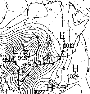
The broadscale analysis for 10am EST this morning as the deep low midway between Antractica and Australia bottomed out at 945hPa. BoM

The National Weather Extremes top wind gusts box below tells the story of a remarkably windy day across the southern halves of SA and NSW, and Victoria and Tasmania. An extreme pressure gradient between a 945hPa low southwest of Tasmania and a 1012 high over southern Queensland produced widespread gales, and peak wind gusts recorded close to midnight at 122km/h at both Mt Buller and Fawkner Beacon in Port Phillip Bay in Victoria. Many un-exposed stations recorded sustained gales with storm-force gusts.

Across Victoria, over 2,500 calls for assistance were received by the SES, whose spokesperson, Rhys Maggs, said it was one of the most signifcant storms on record. Preliminary estimates by the Insurance Council of Australia put the damage bill at $3m. In Melbourne, 450 SES volunteers responded to hundreds of calls overnight as trees came down and roofing was blown off. Every Melbourne suburb was affected. Volunteers had to be brought in from outside Melbourne to help. A nursing hostel in West Gippsland had to be evacuated when large sections of its roof were blown off. Police closed Westgate Bridge to traffic for about an hour at the height of the gale.

In Victoria's northwest, a house was unroofed at Koreleigh near Swan Hill, and a gum tree was blown onto a flat at Mildura. Downed powerlines cut electricity to 500 users at Portland in the state's west. A number of houses in Broadford and Kilmore suffered roof damage, while there were reports of cars around Shepparton being caked with red mud as wind-borne dust was followed by light rain. Many trees were brought down, hitting power lines and causing blackouts. SES emergency management officer Gavin Kelly said "We were looking at a number of areas and surprisingly enough Alexandra was one of those. Alexandra rarely suffers from a wind storm and they had winds there gusting last night
up to 76 kilometres an hour. In around Kilmore, Broadford, Strathcreek and Kinglake had a number down, and Beechworth as well." In Alexandra, the wind devastated the Alexandra Racing Club, with 70 horse stalls destroyed, roofing ripped from the clubroom, and trees and powerlines downed. A steel power pole was snapped in two by the wind. Less obvious but more serious damage was caused to western Victoria's grain crop, with the strong winds accompanied by warm temperatures stripping moisture from crops.

In Canberra, heavy rain accompanied strong winds to produce a spate of minor car accidents, while fallen trees and power lines produced power outages. A wind storm late this afternoon in the Hunter Valley of NSW caused most damage around Lake Macquarie, where the Warners Bay Post Office suffered damage to its roof, awnings and windows, and a large industrial shed at Morisset was blown off its foundations. Trees and power lines were brought down at Mayfield in Newcastle, and at Medowie, 20km NE of the city. Five thousand customers were affected by power outages.

It has been an unusually warm night and day in northern NSW and southern Queensland. Both overnight and daytime temperatures were 6 to 11° above average in a broad band running from southwestern Queensland to the NSW Mid North Coast (see temperature variation extremes below).

DROUGHTWATCH

The small settlement of Coolabah, between Nyngan and Bourke in NSW, has run out of water. The towns dam is now dry, and water is being carted in for the population of 40. The dam was substantially extended after the last drought, and locals are pointing to this and the small population as an indication of the severity of the drought in western NSW.

National weather extremes for today
Data provided by the Bureau of Meteorology
Last updated at 19:25 EST on 06/09/02

Quality control note: Data is complete, and has been visually checked by AWN for gross errors. Less obvious errors may remain. See Explanation of Extremes Pages for more information
Records set this day (none known)

Todays highest rainfall totals for the 24 hours to 9am. It includes the top 5 totals received, and/or all reported falls of 50mm or more.

60.0 PERISHER VALLEY SKI CENTRE Snowy Mtns NSW
57.5 THREDBO VILLAGE Snowy Mtns NSW
47.0 THREDBO (CRACKENBACK STATION) AWS Snowy Mtns NSW
30.0 TIDBINBILLA NATURE RESERVE Goulburn/Monaro NSW

NEW SOUTH WALES
    Goulburn/Monaro
30.0 TIDBINBILLA NATURE RESERVE
    Snowy Mtns
60.0 PERISHER VALLEY SKI CENTRE
57.5 THREDBO VILLAGE
47.0 THREDBO (CRACKENBACK STATION) AWS

High rainfall for periods of 6 hours or less.


NEW SOUTH WALES
    Snowy Mtns
THREDBO (CRACKENBACK STATION) AWS
8.6mm in 46 min to 04:00 11.2mm/h
30.0mm in 3 hr to 06:00 10.0mm/h
    SW Slopes S
CABRAMURRA SMHEA AWS
22.0mm in 3 hr to 06:00 7.3mm/h

VICTORIA
    Lower NE
HUNTERS HILL
8.2mm in 46 min to 04:00 10.7mm/h
17.0mm in 3 hr to 06:00 5.7mm/h

Todays highest & lowest temperatures

Maximum Minimum
36.6 BOULIA AIRPORT Channel Country QLD
36.3 LONGREACH AERO Central West QLD
36.0 WYNDHAM AERO N Kimberley WA
35.8 URANDANGIE Northwest QLD
35.5 WAVE HILL Victoria NT
35.5 KIDMAN SPRINGS Victoria NT
26.0 NORTHERN ENDEAVOUR Islands
24.2 TROUGHTON ISLAND N Kimberley WA
24.0 MCCLUER ISLAND Darwin-Daly NT
23.7 BEDOURIE POLICE STATION Channel Country QLD
23.5 HORN ISLAND N Peninsula QLD
2.0 THREDBO (CRACKENBACK STATION) AWS Snowy Mtns NSW
3.4 CHARLOTTE PASS (KOSCIUSKO CHALET) Snowy Mtns NSW
4.0 PERISHER VALLEY SKI CENTRE Snowy Mtns NSW
6.0 CABRAMURRA SMHEA AWS SW Slopes S NSW
6.1 MOUNT READ W Coast TAS
-1.0 THREDBO (CRACKENBACK STATION) AWS Snowy Mtns NSW
-0.7 CHARLOTTE PASS (KOSCIUSKO CHALET) Snowy Mtns NSW
-0.5 PERISHER VALLEY SKI CENTRE Snowy Mtns NSW
0.0 DALWALLINU COMPARISON Central West WA
0.0 MOUNT BULLER Upper NE VIC

Todays greatest temperature variations from normal

Maximum Minimum
+10.0   35.0 MUNGINDI POST OFFICE NW Plains W NSW
+9.6   35.1 BOLLON MARY ST Warrego QLD
+8.9   34.7 CHARLEVILLE AERO Warrego QLD
+8.7   31.7 YARRAS (MOUNT SEAVIEW) MidNorth Coast S NSW
+8.5   27.9 INVERELL RESEARCH CENTRE N Tablelands W NSW
+8.5   32.5 KEMPSEY (WIDE STREET) MidNorth Coast N NSW
+8.5   31.0 TAREE (RADIO STATION 2RE) MidNorth Coast S NSW
+11.4   17.3 BARADINE FORESTRY NW Plains E NSW
+10.8   21.7 THARGOMINDAH POST OFFICE Far SW QLD
+10.4   19.3 BREWARRINA HOSPITAL Upper Darling NSW
+9.8   21.6 WINDORAH POST OFFICE Channel Country QLD
+9.3   19.0 CHARLEVILLE AERO Warrego QLD
-6.1   21.7 THREE RIVERS E Gascoyne WA
-6.0   19.8 MURCHISON W Gascoyne WA
-6.0   19.5 MEEKATHARRA AIRPORT Murchison WA
-5.9   27.0 TELFER AERO Interior WA
-5.2   23.0 GASCOYNE JUNCTION W Gascoyne WA
-5.2   25.3 NYANG STATION W Gascoyne WA
-5.2   20.4 YEELIRRIE Goldfields WA
-8.1   3.0 WARBURTON AIRFIELD Interior WA
-7.9   0.0 DALWALLINU COMPARISON Central West WA
-7.5   8.6 GEORGETOWN POST OFFICE Upper Carpentaria QLD
-7.5   5.3 KAIRI RESEARCH STATION N Coast--Barron QLD
-6.5   3.2 THREE RIVERS E Gascoyne WA

Highest wind gusts above 89km/h or mean wind above 62km/h (gale force). Wind direction and mean windspeed shown in brackets.

MOOMBA AIRPORT NE Pastoral SA : 80 (310/ 67 ) at 00:26
MOUNT LOFTY Mt Lofty Ranges SA : 102 (290/ 69 ) at 02:00
NARACOORTE AERODROME Lower SE SA : 76 (320/ 67 ) at 01:13
TIBOOBURRA AIRPORT Far Northwest NSW: 83 (280/ 63 ) at 01:36
COBAR AIRPORT AWS Upper Darling NSW: 91 (280/ 65 ) at 03:12
NEWCASTLE NOBBYS SIGNAL STATION Hunter Valley NSW: 83 (300/ 65 ) at 14:38
NOWRA RAN AIR STATION AWS Illawarra NSW: 83 (300/ 65 ) at 12:56
BELLAMBI AWS Illawarra NSW: 96 (290/ 65 ) at 07:35
MOSS VALE AWS Illawarra NSW: 93 (320/ 50 ) at 06:28
ALBION PARK (WOLLONGONG AIRPORT) Illawarra NSW: 93 (300/ 65 ) at 06:47
MONTAGUE ISLAND LIGHTHOUSE South Coast NSW: 91 ( 10/ 70 ) at 05:10
ULLADULLA AWS South Coast NSW: 91 (300/ 41 ) at 07:00
BOMBALA AWS Goulburn/Monaro NSW: 83 (290/ 63 ) at 10:32
THREDBO (CRACKENBACK STATION) AWS Snowy Mtns NSW: 113 (320/ 83 ) at 09:30
GRIFFITH AIRPORT AWS Riverina W NSW: 91 (280/ 58 ) at 01:47
MOUNT BULLER Upper NE VIC: 122 (360/ 74 ) at 00:00
FALLS CREEK Upper NE VIC: 98 (340/ 59 ) at 02:30
MT HOTHAM Upper NE VIC: 109 (360/ 78 ) at 01:23
GELANTIPY E Gippsland VIC: 89 (360/ 69 ) at 01:52
ORBOST E Gippsland VIC: 80 (350/ 63 ) at 00:12
WILSONS PROMONTORY LIGHTHOUSE W Gippsland VIC: 100 (290/ 58 ) at 05:25
KINGFISH A SHIP LOG 206 W Gippsland VIC: 76 (294/ 63 ) at 04:20
LOOKOUT HILL Western Plains VIC: 91 (330/ 56 ) at 22:30
COLAC (MT GELLIBRAND) W Coast VIC: 89 (300/ 67 ) at 06:01
CAPE GRIM B.A.P.S. N Coast TAS: 89 (280/ 65 ) at 09:00
EDDYSTONE POINT E Coast TAS: 95 (280/ 70 ) at 16:05
MAATSUYKER ISLAND LIGHTHOUSE Southeast TAS: 111 (330/ 89 ) at 23:03
MOUNT WELLINGTON Southeast TAS: 115 (320/ 87 ) at 20:26
TASMAN ISLAND Southeast TAS: 98 ( 10/ 74 ) at 00:21
HARTZ MOUNTAIN(KEOGHS PIMPLE) Southeast TAS: 93 (290/ 61 ) at 11:30
KING ISLAND AIRPORT King Island TAS: 91 (300/ 72 ) at 05:31
FLINDERS ISLAND AIRPORT Flinders Is/Bass St TAS: 80 (290/ 65 ) at 08:50

Other extremes

..