Australian Weather News


AWN Home Page
Full news index

Monday, 16 SEP 2002

About Australian Weather News

Widespread gale damage in the southeast 3/12/02, 24/12/02
Hot night in the east, cold in the west

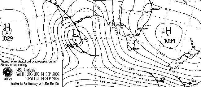
Six-hourly surface analyses from 12UTC (10pm EST) 14 September to 00UTC (10am EST) 16 September. BoM

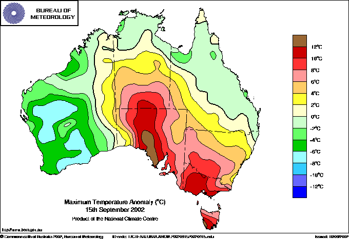
What a difference a day makes! Maximum temperature departures from normal for yesterday and today. Parts of SW SA that were 13° above average yesterday were 7 below today. BoM

Prolonged gale force winds caused extensive damage in South Australia, NSW, Victoria and Tasmania yesterday and today. The animation above shows the cause. A low of 986hPa under WA on Saturday night moved due east across the Bight yesterday afternoon while deepening to 981hPa and massively tightening the pressure gradient to a 1035 high in the central Tasman Sea. The High continued to refuse to budge overnight as the low drove around it to the southeast, deepening to 969hPa at 10 this morning when due south of Tasmania. Pressure gradients of this magnitude are most unusual in the Australian region, and widespread, severe gales resulted. Full details of wind averages and gusts are in the wind extremes box below.

In South Australia persistent gale force winds yesterday, gusting as high as 117km/h, raised widespread duststorms and prompted 800 emergency services calls to deal with unroofed houses, flattened sheds and fences, and trees on roads and houses. The greatest damage occurred on the easterh half of the Eyre Peninsula, Yorke Peninsula and the northern Spencer Gulf areas, with Whyalla alone accounting for 183 of the emergency calls. Warooka and Maitland each generated about 40 calls. Several houses in the area lost verandahs or parts of their roofs, and dozens of farm sheds and buildings were badly damaged. Tree damage was widespread, several boats were damaged when they broke their moorings, and powerlines were brought down. The damage bill is put at around $1m. On the Yorke peninsula, wind gusted to 108km/h (averaging 82) at Edithburgh, while on the Eyre Peninsula, Port Lincoln reported 104km/h and Wudina, Cleve, Whyalla and Coulta all reported gusts in the mid 90s. The gales produced duststorms that lifted large areas of topsoil in the Riverland and Mallee areas, adding insult to injury for farmers praying for rain. Many crops that were marginal have been ruined by the combination of heat stress and high wind. The highest wind gusts recorded were 117km/h at Minlaton Airport on the Yorke Peninsula and at Mt Lofty summit and Sellicks Beach, both near Adelaide. At Minlaton, the wind exceeded gale force for nine and a half hours, an unusually long duration for this area.

In Victoria the SES responded to 600 calls to deal with unroofed houses and downed trees and power poles. Most were from metropolitan Melbourne where the wind gusted to 85km/h at Melbourne and Moorabin Airports, 87km/h at Frankston, and 106km/h at Dunns Hill near Mt Dandenong. Most of the strongest gusts were recorded around 5.30am during the period of maximum pressure gradient across the city. Winds actually eased as the axis of the pressure trough passed through late morning ahead of the main front about 4pm. Damage was less than expected because many vulnerable trees and structures were blown down in the gales two weeks ago. Widespread wind damage and blocked roads were also reported from the Ballarat area. More fires flared up during the night, with the CFA called to over 300 incidents, 100 of them grass and scrub fires. The serious fire at Mt Monarch west of Ballarat threatened homes, while significant fires were also burning at Apollo Bay and at Westburn near Warburton. All fires were under control by late afternoon. The highest wind gusts recorded were at Mt Gellibrand near Colac, 117km/h, and the summit of Mt Hotham 139km/h, though there was an unofficial report of a wind gust of 190km/h at Mt Buller. Heavy rain fell across central and northeastern Victoria during the afternoon, with Edi Upper, 35km SSE of Wangaratta, recording 50mm between 9am and 3pm, and Hunters Hill near Koetong in the northeast reporting 53mm between noon and 6pm.

Wind damage was also reported from the NSW Snowy Mountains ski resorts, with a lodge in each of the Kosciuszko Chalet, Perisher Valley and Thredbo areas unroofed. The anemometer on Crackenback Range above Thredbo recorded its highest-ever peak gust of 154km/h with a sustained windspeed of 121km/h at 10am. In Tasmania, the wind gusted to 98km/h in central Hobart, and a top gust of 135km/h (average 111) atop Mt Wellington. A brick wall of a house in the Hobart suburb of Berriedale collapsed in the wind while a tree came down on powerlines in the state's northeast disrupting power for 10 hours.

There were strongly contrasting overnight temperature differences across the country. A 400km-wide belt running 1,500km from southeastern NT to eastern Victoria recorded mimina between 6 and 13° above average, while most of southern WA was between 4 and 9 below. Pearce RAAF Base, 35km NNE of Perth, recorded its coldest September minimum in 42 years of computer record when the temperature dropped to 0.7.

National weather extremes for today
Data provided by the Bureau of Meteorology
Last updated at 23:17 EST on 17/09/02

Quality control note: Data is complete, and has been visually checked by AWN for gross errors. Less obvious errors may remain. See Explanation of Extremes Pages for more information
Records set this day (previous record and years of computerised record shown in brackets):
Lowest daily minimum temperature for September:
Pearce RAAF WA: 0.7 (0.8, 42)

Todays highest rainfall totals for the 24 hours to 9am. It includes the top 5 totals received, and/or all reported falls of 50mm or more.

40.0 DUM IN MIRRIE Darwin-Daly NT
37.4 GERIATRIC PARK Darwin-Daly NT
37.0 LIAWENEE COMPARISON Central Plateau TAS
33.4 QUAMBY BLUFF(WILDLIFE NURSERY) N Coast TAS
31.4 LIAWENEE AWS Central Plateau TAS

NORTHERN TERRITORY
    Darwin-Daly
40.0 DUM IN MIRRIE
37.4 GERIATRIC PARK

TASMANIA
    N Coast
33.4 QUAMBY BLUFF(WILDLIFE NURSERY)
    Central Plateau
37.0 LIAWENEE COMPARISON
31.4 LIAWENEE AWS

High rainfall for periods of 6 hours or less.


WESTERN AUSTRALIA
    Central West
GERALDTON AIRPORT
10.2mm in 30 min to 01:00 20.4mm/h
10.2mm in 1 hr to 01:00 10.2mm/h

NORTHERN TERRITORY
    Darwin-Daly
DUM IN MIRRIE
40.0mm in 3 hr to 09:00 13.3mm/h

NEW SOUTH WALES
    SW Slopes S
ALBURY AIRPORT
15.0mm in 3 hr to 15:00 5.0mm/h
ALBURY AIRPORT AWS
15.0mm in 3 hr to 15:00 5.0mm/h

VICTORIA
    Lower NE
HUNTERS HILL
13.2mm in 1 hr to 15:00 13.2mm/h
28.0mm in 3 hr to 15:00 9.3mm/h
9.2mm in 54 min to 17:00 10.2mm/h
10.2mm in 1 hr to 17:00 10.2mm/h
25.0mm in 3 hr to 18:00 8.3mm/h
    Upper NE
MT HOTHAM AIRPORT
16.0mm in 3 hr to 15:00 5.3mm/h
EDI UPPER
50.0mm in 6 hr to 15:00 8.3mm/h
MT HOTHAM
17.0mm in 3 hr to 15:00 5.7mm/h
20.0mm in 3 hr to 18:00 6.7mm/h
    E Central
DUNNS HILL
18.0mm in 3 hr to 12:00 6.0mm/h

TASMANIA
    Central Plateau
LIAWENEE AWS
15.0mm in 3 hr to 09:00 5.0mm/h

Todays highest & lowest temperatures

Maximum Minimum
39.0 WYNDHAM AERO N Kimberley WA
37.0 WYNDHAM POST OFFICE N Kimberley WA
37.0 KALUMBURU N Kimberley WA
37.0 MCARTHUR RIVER MINE Roper-McArthur NT
36.4 ARGYLE AERODROME E Kimberley WA
26.4 WYNDHAM POST OFFICE N Kimberley WA
25.0 KUNUNURRA AERO E Kimberley WA
25.0 WARRUWI Arnhem NT
24.8 TROUGHTON ISLAND N Kimberley WA
24.4 KIMBERLEY RES.STATION E Kimberley WA
4.0 THREDBO (CRACKENBACK STATION) AWS Snowy Mtns NSW
6.0 MT HOTHAM Upper NE VIC
6.1 LIAWENEE AWS Central Plateau TAS
7.4 CHARLOTTE PASS (KOSCIUSKO CHALET) Snowy Mtns NSW
7.4 CRADLE MOUNTAIN AIRSTRIP Central Plateau TAS
-3.2 CHARLOTTE PASS (KOSCIUSKO CHALET) Snowy Mtns NSW
-1.7 CUNDERDIN AIRFIELD Cent Wheatbelt WA
-1.0 BROOKTON Gt Southern WA
-1.0 WANDERING COMPARISON Gt Southern WA
-1.0 WANDERING Gt Southern WA
-1.0 SOUTHERN CROSS AIRFIELD Goldfields WA

Todays greatest temperature variations from normal

Maximum Minimum
+8.6   26.5 NAROOMA RVCP South Coast NSW
+8.3   26.9 MORUYA HEADS PILOT STATION South Coast NSW
+7.8   24.6 MOORABBIN AIRPORT E Central VIC
+7.8   24.0 SCORESBY RESEARCH INSTITUTE E Central VIC
+7.5   25.7 COWRA AIRPORT CW Slopes S NSW
+13.3   19.0 GRIFFITH AIRPORT AWS Riverina W NSW
+12.8   19.0 NARRANDERA GOLF CLUB Riverina E NSW
+12.7   17.0 RUTHERGLEN RESEARCH Lower NE VIC
+12.2   23.0 JERVOIS Alice Springs NT
+11.2   16.4 WAGGA WAGGA AMO SW Slopes S NSW
-9.3   19.0 CARNEGIE Interior WA
-9.2   18.0 GILES METEOROLOGICAL OFFICE Interior WA
-8.4   19.0 WARBURTON AIRFIELD Interior WA
-8.4   14.0 NULLARBOR ROADHOUSE W Agricultural SA
-8.2   18.0 WILUNA Interior WA
-8.3   0.7 PEARCE RAAF Lower West WA
-8.2   5.7 NYANG STATION W Gascoyne WA
-7.9   1.0 PERTH AIRPORT Lower West WA
-7.8   1.0 MEDINA RESEARCH CENTRE Lower West WA
-6.9   0.8 WONGAN HILLS Central West WA

Highest wind gusts above 89km/h or mean wind above 62km/h (gale force). Wind direction and mean windspeed shown in brackets.

MONTAGUE ISLAND LIGHTHOUSE South Coast NSW: 78 (350/ 65 ) at 18:25
THREDBO (CRACKENBACK STATION) AWS Snowy Mtns NSW: 154 (320/121 ) at 10:00
SWAN HILL AERODROME Mallee S VIC: 83 (350/ 69 ) at 05:05
MOUNT BULLER Upper NE VIC: 100 (360/ 67 ) at 07:00
MT HOTHAM AIRPORT Upper NE VIC: 102 (320/ 63 ) at 11:07
MT HOTHAM Upper NE VIC: 139 (350/108 ) at 08:00
KINGFISH A SHIP LOG 206 W Gippsland VIC: 74 ( 2/ 65 ) at 09:40
MT MOORNAPA W Gippsland VIC: 93 (330/ 30 ) at 08:59
MOORABBIN AIRPORT E Central VIC: 85 (360/ 63 ) at 05:31
MELBOURNE AIRPORT E Central VIC: 85 (360/ 67 ) at 00:00
FRANKSTON AWS E Central VIC: 87 (360/ 63 ) at 05:29
DUNNS HILL E Central VIC: 106 ( 10/ 72 ) at 05:30
RHYLL E Central VIC: 95 (340/ 61 ) at 03:15
FAWKNER BEACON E Central VIC: 95 ( 10/ 70 ) at 01:15
POINT WILSON W Central VIC: 87 (360/ 63 ) at 01:30
KILMORE GAP N Central VIC: 98 (360/ 74 ) at 06:00
CAPE OTWAY LIGHTHOUSE W Coast VIC: 82 (350/ 63 ) at 00:30
COLAC (MT GELLIBRAND) W Coast VIC: 117 (350/ 98 ) at 01:30
HAMILTON AIRPORT W Coast VIC: 82 (350/ 67 ) at 00:39
AIREYS INLET W Coast VIC: 96 (350/ 72 ) at 00:06
CAPE GRIM B.A.P.S. N Coast TAS: 95 (360/ 59 ) at 03:00
HOBART (ELLERSLIE ROAD) Southeast TAS: 98 (340/ 65 ) at 05:00
MAATSUYKER ISLAND LIGHTHOUSE Southeast TAS: 115 (310/ 96 ) at 15:00
MOUNT WELLINGTON Southeast TAS: 135 (320/111 ) at 04:00
TASMAN ISLAND Southeast TAS: 89 (300/ 63 ) at 12:15
HARTZ MOUNTAIN(KEOGHS PIMPLE) Southeast TAS: 93 (280/ 67 ) at 15:28
CAPE BRUNY (CAPE BRUNY) Southeast TAS: 104 (300/ 80 ) at 13:31
KING ISLAND AIRPORT King Island TAS: 82 (330/ 65 ) at 02:34

Other extremes

..