 Widespread
rain in NSW, Vic Widespread
rain in NSW, Vic
NEWSBITS: Minor flooding, snow, gales in Tas  3/12/02 3/12/02 |
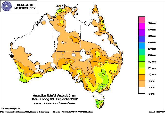 |

R infall for the week ended 9am Wednesday 18 September. Most of
the rain across southern Australia was produced by the major low
pressure system that passed under the continent over the past few
days. BoM |
Worthwhile rain fell yesterday and today
over much of NSW and Victoria. As shown on the map at right, there
were general falls of 10 to 25mm, with an area of heavier rain in northeastern
Victoria, and on the NSW Southwest Slopes and Central West. The rain will
help crops that have survived the drought, and promote pasture growth
for starving stock. Quandialla, 70km SSW of Forbes NSW, recorded
its highest September daily rainfall total in 76 years with 44.8mm. There
were also heavy falls in the Alps, with rain turning to snow. Thredbo
Village recorded 76.4mm for the 24 hours to 9am.
NEWSBITS:
Minor or near minor flooding peaked in several northern Tasmanian rivers
late yesterday or today. Rivers affected were the St Patricks and
North Esk, upper South Esk and Meander.
Light snowfalls continued on the Tasmanian Central Plateau overnight
and this morning, with Lake St Clair, Liawenee and Cradle Valley Airstrip
all reporting falling snow at 9am. Strong winds again caused damage,
with a house roof blown 400m by galeforce winds at Rocky Cape in the state's
northwest.
|
|
National
weather extremes for today
Data provided by
the Bureau of Meteorology
Last updated at 22:42 EST on 19/09/02 |
| Quality
control note: Data is complete, and has been visually checked by AWN for gross errors.
Less obvious errors may remain. See Explanation of Extremes Pages for more information |
Records
set this day (previous record and years of computerised record shown in
brackets):
Highest daily rainfall for September:
Quandialla
PO NSW: 44.8 (43.7, 76) |
|
Todays highest
rainfall totals for the 24 hours to 9am. It includes the top 5 totals received, and/or all reported falls of 50mm or more.
76.4 THREDBO VILLAGE Snowy Mtns NSW
66.4 KING RIVER (WHITFIELD) Lower NE VIC
65.0 MT HOTHAM Upper NE VIC
64.0 HALLS (UPPER BUCKLAND) Upper NE VIC
63.0 HUNTERS HILL Lower NE VIC
NEW SOUTH WALES
Snowy Mtns
76.4 THREDBO VILLAGE
61.0 PERISHER VALLEY SKI CENTRE
52.6 CHARLOTTE PASS (KOSCIUSKO CHALET)
SW Slopes S
57.6 BATLOW POST OFFICE
50.2 ARGALONG (SANDY CREEK)
SW Slopes N
51.0 YOUNG (KIAH)
50.0 STOCKINBINGAL POST OFFICE
VICTORIA
Lower NE
66.4 KING RIVER (WHITFIELD)
63.0 HUNTERS HILL
55.4 KOETONG
53.6 UPPER FIFTEEN MILE CREEK (HANDCOCKS)
50.4 UPPER BOGGY CREEK (MYRRHEE)
Upper NE
65.0 MT HOTHAM
64.0 HALLS (UPPER BUCKLAND)
59.0 EUROBIN
58.0 OVENS RIVER (HARRIETVILLE)
57.7 BRIGHT
56.2 LAKE BUFFALO
55.0 WHITLANDS (BURDER'S LANE)
54.0 EDI UPPER
|
High rainfall for periods of 6 hours or less.
NEW SOUTH WALES
CW Plains S
WEST WYALONG AIRPORT AWS
16.0mm in 3 hr to 00:00 5.3mm/h
CONDOBOLIN AIRPORT
10.0mm in 1 hr to 00:00 10.0mm/h
17.0mm in 3 hr to 00:00 5.7mm/h
Hunter Valley
MURRURUNDI POST OFFICE
15.0mm in 3 hr to 12:00 5.0mm/h
CW Slopes S
PARKES AIRPORT AWS
15.0mm in 3 hr to 03:00 5.0mm/h
FORBES AIRPORT AWS
17.0mm in 3 hr to 03:00 5.7mm/h
SW Slopes N
YOUNG AIRPORT
16.0mm in 3 hr to 00:00 5.3mm/h
|
|
Todays highest &
lowest temperatures |
| Maximum |
Minimum |
38.0 KALUMBURU N Kimberley WA
37.0 WYNDHAM AERO N Kimberley WA
37.0 KALUMBURU MISSION N Kimberley WA
37.0 KIMBERLEY RES.STATION E Kimberley WA
37.0 BRADSHAW Darwin-Daly NT
|
27.0 NORTHERN ENDEAVOUR Islands
25.0 DELAMERE WEAPONS RANGE Darwin-Daly NT
25.0 BRADSHAW Darwin-Daly NT
25.0 CAPE FOURCROY Islands
24.9 KIDMAN SPRINGS Victoria NT
|
0.0 THREDBO (CRACKENBACK STATION) AWS Snowy Mtns NSW
0.0 MOUNT BULLER Upper NE VIC
0.7 MT HOTHAM Upper NE VIC
2.2 MOUNT WELLINGTON Southeast TAS
2.5 PERISHER VALLEY SKI CENTRE Snowy Mtns NSW
|
-5.1 MOUNT WELLINGTON Southeast TAS
-4.0 MOUNT BULLER Upper NE VIC
-3.4 MT HOTHAM Upper NE VIC
-3.2 LIAWENEE AWS Central Plateau TAS
-2.9 MOUNT READ W Coast TAS
|
Todays greatest temperature variations from normal |
| Maximum |
Minimum |
+5.4
29.0 DENHAM W Gascoyne WA
+4.7
26.6 YAMBA PILOT STATION North Coast NSW
+4.0
27.0 MORAWA POST OFFICE Central West WA
+3.8
22.0 WANDERING COMPARISON Gt Southern WA
+3.7
28.0 CARNARVON AIRPORT W Gascoyne WA
+3.7
27.0 MULLEWA Central West WA
+3.7
29.0 UNIVERSITY OF QUEENSLAND GATTON Brisbane/SE Coast QLD
|
+9.3
13.5 BARRABA POST OFFICE NW Slopes N NSW
+9.0
16.3 MITCHELL POST OFFICE Maranoa QLD
+9.0
16.9 SCONE SCS Hunter Valley NSW
+8.5
13.5 MURRURUNDI POST OFFICE Hunter Valley NSW
+8.3
16.7 PEATS RIDGE (WARATAH ROAD) Hunter Valley NSW
|
-8.7
16.2 COLLARENEBRI (VIEWPOINT) Upper Darling NSW
-8.5
24.0 ALI CURUNG Alice Springs NT
-8.5
21.0 JERVOIS Alice Springs NT
-8.4
16.3 BREWARRINA HOSPITAL Upper Darling NSW
-8.0
19.2 TAMBO POST OFFICE Central Highlands QLD
-8.0
17.5 BOLLON MARY ST Warrego QLD
|
-9.1
4.4 WATARRKA Alice Springs NT
-8.4
4.4 GILES METEOROLOGICAL OFFICE Interior WA
-7.1
4.8 CARNEGIE Interior WA
-7.1
2.5 CURTIN SPRINGS Alice Springs NT
-7.1
3.8 KULGERA Alice Springs NT
|
|
Highest wind
gusts above 89km/h or mean wind above 62km/h (gale force). Wind direction and mean windspeed shown in brackets.
NARRABRI AIRPORT AWS NW Slopes N NSW: 76 (260/ 63 ) at 15:14
WILSONS PROMONTORY LIGHTHOUSE W Gippsland VIC: 100
(270/ 52 ) at 22:38
COLAC (MT GELLIBRAND) W Coast VIC: 87 (300/ 69 ) at 23:58
CAPE GRIM B.A.P.S. N Coast TAS: 93 (280/ 74 ) at 23:00
EDDYSTONE POINT E Coast TAS: 74 (280/ 63 ) at 15:34
MAATSUYKER ISLAND LIGHTHOUSE Southeast TAS: 121 (320/100 ) at 23:31
MOUNT WELLINGTON Southeast TAS: 109 (300/ 76 ) at 22:11
HARTZ MOUNTAIN(KEOGHS PIMPLE) Southeast TAS: 106 (280/ 78 ) at 23:39
CAPE BRUNY (CAPE BRUNY) Southeast TAS: 89 (290/ 74
) at 23:52
|
Other extremes
.. |