Australian Weather News


AWN Home Page
Full news index

Wednesday, 25 SEP 2002

About Australian Weather News

Record heat, bushfires in NSW/Qld border country
NEWSBITS: Strong inversion given NSW weird overnight temperatures

Yesterday's heat spread east into NE NSW and central Queensland today providing a raft of new October high temperature records (see below), and the hottest October day in at least 30 to 40 years. The temperature at Longreach Qld reached 40.1° and a number of centres in northwestern Queensland recorded 39. Northeast of Crows Nest, 40km north of Toowoomba, a fire that was started last Sunday has burnt through 1000ha of farm country and is still out of control

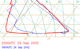
The lowest 10,000 feet of this morning's 6am radiosonde balloon ascent trace from Sydney Airport. BoM

NEWSBITS: An unusually strong temperature inversion led to a reversal of the usual temperature pattern across eastern NSW this morning, with places like Bowral and the upper Blue Mountains recording overnight temperatures close to 20° while sheltered coastal valleys were well below 10°.

The Skew-T diagram for Sydney Airport at right explains why. The straight brown lines skewed from left to right show temperature, with the scale from 0 to 30 across the bottom. The four horizontal lines above the baseline show the points at which pressure was measured at 1000, 900, 800 and 700hPa. The right-hand blue line shows the temperature recorded as yesterday's 3pm balloon ascended, starting at 26° at the surface, kicking down then up slightly before dropping evenly away to 3° at 700hPa, or about 10,000 feet. The left-hand blue line shows the dew point, with the air very dry immediately above the surface where a light seabreeze was bringing in moisture.

The red lines are for this morning's 6am ascent. From a surface temperature of 16.5, the thermometer rose to 26° a few hundred feet up, and only equalled the surface temperature when it reached 830hPa, or about 5,000 feet. Surface winds were negligible, but increased rapidly to 35 to 45km/h northwesterlies at about 500 feet. Yesterday's seabreeze moisture clings to the surface, protected by the inversion.

In the Hunter Valley, Cessnock, which spent the night under the inversion, recorded a 6am temperature of 6.8, while Murrurundi in the Upper Hunter was 19. With a big inversion not far above ground level and a windflow close to the critical level needed to disturb substantially cooler, moister air below, there were quite a few observations of the inversion being blown out and suddenly replaced by much warmer air. Forbes airport reported a temperature of 26.3 at 1.36am with a northerly averaging 59km/h and gusting to 77, while Parkes reported 25.4° at 3.04am with a NNW of 61 gusting 81.

National weather extremes for today
Data provided by the Bureau of Meteorology
Last updated at 18:04 EST on 26/09/02

Quality control note: Data is complete, and has been visually checked by AWN for gross errors. Less obvious errors may remain. See Explanation of Extremes Pages for more information
Records set this day (previous record and years of computerised record shown in brackets):
Highest daily maximum temperature for September:
Surat PO Qld: 37.4 (36.8, 38)
Pindari Dam NSW: 33.1 (32.7, 31)
Woolbrook NSW: 28.4 (28.2, 31)
Glen Innes PO NSW: 28.0 (27.9, 39)
Glen Innes Ag Res Stn NSW: 28.0 (27.0, 31)
Inverell Res Centre NSW: 31.2 (30.8, 37)
Grafton Olympic Pool NSW: 37.5 (37.2, 35)

Todays highest rainfall totals for the 24 hours to 9am. It includes the top 5 totals received, and/or all reported falls of 50mm or more.

21.4 GRAY (CRAIGIE-LEA) E Coast TAS
19.6 ST MARYS (GROOM STREET) E Coast TAS
18.0 ERRIBA (JUBB ROAD) N Coast TAS
15.4 LILYDALE POST OFFICE N Coast TAS
13.8 SCAMANDER E Coast TAS

TASMANIA
    N Coast
18.0 ERRIBA (JUBB ROAD)
15.4 LILYDALE POST OFFICE
    E Coast
21.4 GRAY (CRAIGIE-LEA)
19.6 ST MARYS (GROOM STREET)
13.8 SCAMANDER

High rainfall for periods of 6 hours or less.

None reported

Todays highest & lowest temperatures

Maximum Minimum
40.6 WARMUN E Kimberley WA
40.1 LONGREACH AERO Central West QLD
39.6 ARGYLE AERODROME E Kimberley WA
39.0 WYNDHAM AERO N Kimberley WA
39.0 FITZROY CROSSING AERO W Kimberley WA
39.0 FLYING FOX Roper-McArthur NT
39.0 LAJAMANU Victoria NT
39.0 WAVE HILL Victoria NT
39.0 JULIA CREEK AIRPORT Gulf Country QLD
39.0 CAMOOWEAL TOWNSHIP Northwest QLD
39.0 CANNINGTON MINE Northwest QLD
39.0 URANDANGIE Northwest QLD
39.0 BOULIA AIRPORT Channel Country QLD
28.2 ELCHO ISLAND Arnhem NT
27.0 NORTHERN ENDEAVOUR Islands
25.4 TROUGHTON ISLAND N Kimberley WA
25.0 DELAMERE WEAPONS RANGE Darwin-Daly NT
24.5 TINDAL RAAF Darwin-Daly NT
3.0 THREDBO (CRACKENBACK STATION) AWS Snowy Mtns NSW
4.0 MOUNT READ W Coast TAS
4.4 CHARLOTTE PASS (KOSCIUSKO CHALET) Snowy Mtns NSW
4.6 MT HOTHAM Upper NE VIC
5.0 PERISHER VALLEY SKI CENTRE Snowy Mtns NSW
5.0 MOUNT BULLER Upper NE VIC
-2.3 CUNDERDIN AIRFIELD Cent Wheatbelt WA
-1.5 BROOKTON Gt Southern WA
-1.4 LIAWENEE AWS Central Plateau TAS
-1.3 YORK Cent Wheatbelt WA

Todays greatest temperature variations from normal

Maximum Minimum
+14.5   37.0 TAREE (RADIO STATION 2RE) MidNorth Coast S NSW
+13.2   34.9 COFFS HARBOUR MO MidNorth Coast N NSW
+13.2   36.2 YARRAS (MOUNT SEAVIEW) MidNorth Coast S NSW
+12.9   37.5 GRAFTON OLYMPIC POOL North Coast NSW
+12.7   34.6 PATERSON (TOCAL) Hunter Valley NSW
+12.3   17.0 BOWRAL (PARRY DRIVE) Illawarra NSW
+12.1   16.4 COWRA AIRPORT CW Slopes S NSW
+11.5   17.2 DUNEDOO POST OFFICE CW Slopes N NSW
+11.0   16.3 KATOOMBA (NARROW NECK RD) C Tablelands S NSW
+10.8   17.0 TRANGIE RESEARCH STATION AWS CW Plains N NSW
-6.2   29.0 ELLIOTT Barkly NT
-3.4   19.0 NULLARBOR ROADHOUSE W Agricultural SA
-3.3   16.0 ESPERANCE SW & S Coast WA
-3.0   21.2 BALGAIR Eucla WA
-2.8   29.0 BROOME AIRPORT W Kimberley WA
-2.8   19.0 SOUTHERN CROSS Goldfields WA
-7.6   -1.0 KELLERBERRIN Cent Wheatbelt WA
-6.9   -1.5 BROOKTON Gt Southern WA
-6.9   -1.0 HYDEN Gt Southern WA
-6.9   11.7 CAIRNS AERO N Coast--Barron QLD
-6.7   0.5 CUNDERDIN Cent Wheatbelt WA

Highest wind gusts above 89km/h or mean wind above 62km/h (gale force). Wind direction and mean windspeed shown in brackets.

NEPTUNE ISLAND W Agricultural SA : 80 (270/ 65 ) at 10:30
COULTA (COLES POINT) W Agricultural SA : 89 (280/ 67 ) at 08:09
MOUNT LOFTY Mt Lofty Ranges SA : 95 (290/ 67 ) at 13:06
COONAWARRA Lower SE SA : 78 (270/ 67 ) at 14:20
THREDBO (CRACKENBACK STATION) AWS Snowy Mtns NSW: 83 (320/ 67 ) at 13:00
WILSONS PROMONTORY LIGHTHOUSE W Gippsland VIC: 93 (270/ 67 ) at 19:59
POINT WILSON W Central VIC: 76 (300/ 63 ) at 18:37
EILDON FIRE TOWER N Central VIC: 85 (260/ 70 ) at 19:36
LOOKOUT HILL Western Plains VIC: 93 (320/ 45 ) at 14:31
COLAC (MT GELLIBRAND) W Coast VIC: 104 (280/ 69 ) at 17:23
PORTLAND (CASHMORE AIRPORT) W Coast VIC: 82 (270/ 69 ) at 17:37
HAMILTON AIRPORT W Coast VIC: 82 (300/ 65 ) at 15:39
PORT FAIRY AWS W Coast VIC: 78 (270/ 65 ) at 18:20
CAPE NELSON LIGHTHOUSE W Coast VIC: 82 (280/ 67 ) at 17:22
CAPE GRIM B.A.P.S. N Coast TAS: 122 (260/ 78 ) at 23:00
SMITHTON AERODROME N Coast TAS: 87 (320/ 65 ) at 20:11

Other extremes

..