Australian Weather News


AWN Home Page
Full news index

Sunday, 01 DEC 2002

About Australian Weather News

Hot in SE WA, SW SA
Storms hit central eastern Qld
Sydney has hottest spring on record as dry continues

Daytime temperatures were up to 20° above average in the far southeast of WA and along the SA west coast today. Eucla's top of 44°, a whopping 19.3 above normal, equalled the highest in the nation and was just one degree short of the station's December record. Nearby Forrest recorded 43.7 while Nullarbor, across the border in SA, recorded 42. A cooler change moved through during the evening, bringing wind gusts of 91km/h at Eucla and 95 at Forrest.

Storms caused damage around Queensland's Central Coast and Highlands this afternoon. At Mount Morgan, 50km SW of Rockhampton, the QN Hotel lost its tower in strong wind gusts, while trees were uprooted and many fruit trees ripped up. At Nagoorin, 50km S of Gladstone, a huge Moreton Bay Fig tree was uprooted.


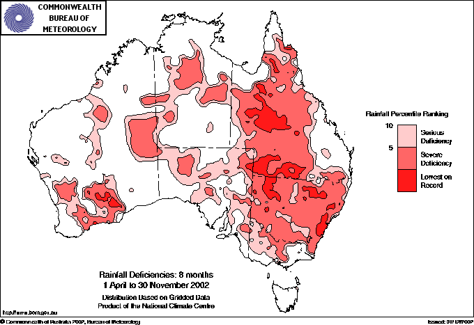
Rainfall deficiencies for the 8 months ended 30 November 2002. Much of NSW and most of Queensland is experiencing severe deficiencies, with large areas recording their lowest April to November rainfall on record. BoM

Sydney has recorded its warmest Spring in 144 years of record. The average maximum temperature was 24.2°, more than 2 above average, while the average minimum temperature was 14.9, the second highest on record. The warm Spring includes 27 days when the temperature exceeded 26, the second highest number of days ever recorded after 28 days in 1928. Sunny days and an absence of rain helped create the record. The season was the fifth driest Spring on record in Sydney with only 59mm compared with the long term average of 230mm. In the western suburbs, Badgerys Creek recorded only 19mm. The dry Spring conditions follow on from Sydney's third driest Winter on record. The period May - October has been the driest on record for that particular six-month period and the third driest on record for any six month period. Sunshine was well above average at 8.4 hours per day.

Across the rest of NSW, and also most of inland Queensland, the drought has continued to intensify as the map at right shows. Most of this area is now in "severe deficiency", meaning that the rain over the period is in the lowest 5% of historical falls. Large areas to the west and south of Sydney and in NW NSW and western Qld have experienced their driest April to November period on record. The situation is so bad that the NSW Government is considering the construction of emergency pipelines to supply water to some 30 towns whose normal water supplies have all but dried up. These include Gloucester and Coonabarabran, whilst water is already being carted into six small communities around the state. From SW Qld comes the news that Cubbie Station will not plant a cotton crop this season due to the drought. The station, near Dirrinbandi, normally accounts for 30,000 of the 40,000 acres planted in the region.

National weather extremes for today
Data provided by the Bureau of Meteorology
Last updated at 06:05 UTC on 02/12/02

Quality control note: Data is complete, and has been visually checked by AWN for gross errors. Less obvious errors may remain. See Explanation of Extremes Pages for more information
Records set this day (none known)

Todays highest rainfall totals for the 24 hours to 9am. It includes the top 5 totals received, and/or all reported falls of 50mm or more.

85.0 LAKEFIELD NATIONAL PARK S Peninsula QLD
52.0 ATHERTON WATER TREAT N Coast--Barron QLD
47.0 COOKTOWN AIRPORT N Coast--Barron QLD
45.0 JERVIS BAY (PT PERPENDICULAR AWS) Illawarra NSW
44.2 TERRITORY WILDLIFE PARK Darwin-Daly NT

NORTHERN TERRITORY
    Darwin-Daly
44.2 TERRITORY WILDLIFE PARK

QUEENSLAND
    S Peninsula
85.0 LAKEFIELD NATIONAL PARK
    N Coast--Barron
52.0 ATHERTON WATER TREAT
47.0 COOKTOWN AIRPORT

NEW SOUTH WALES
    Illawarra
45.0 JERVIS BAY (PT PERPENDICULAR AWS)

High rainfall for periods of 6 hours or less.


WESTERN AUSTRALIA
    E Kimberley
KUNUNURRA AERO
21.8mm in 1 hr to 12:30 21.8mm/h
24.0mm in 3 hr to 15:00 8.0mm/h

NORTHERN TERRITORY
    Darwin-Daly
BATCHELOR AERO
7.4mm in 21 min to 13:54 21.1mm/h
TINDAL RAAF
6.8mm in 11 min to 17:30 37.1mm/h
11.0mm in 1 hr to 17:30 11.0mm/h
15.2mm in 1 hr to 18:00 15.2mm/h
15.0mm in 3 hr to 18:00 5.0mm/h

QUEENSLAND
    Wide Bay/Burnett
GLADSTONE RADAR
4.8mm in 11 min to 18:00 26.2mm/h
18.2mm in 1 hr to 18:30 18.2mm/h
GLADSTONE AIRPORT
9.8mm in 17 min to 18:00 34.6mm/h
11.0mm in 1 hr to 18:00 11.0mm/h
    Brisbane/SE Coast
GYMPIE
6.0mm in 14 min to 16:00 25.7mm/h
23.0mm in 3 hr to 18:00 7.7mm/h

NEW SOUTH WALES
    Illawarra
NOWRA RAN AIR STATION AWS
11.6mm in 1 hr to 05:30 11.6mm/h

Todays highest & lowest temperatures

Maximum Minimum
44.0 EUCLA Eucla WA
44.0 WARBURTON AIRFIELD Interior WA
43.7 FORREST Eucla WA
43.3 TELFER AERO Interior WA
43.0 MARBLE BAR COMPARISON E Pilbara WA
43.0 KINTORE (WULUNGURRU) Alice Springs NT
43.0 JULIA CREEK AIRPORT Gulf Country QLD
31.0 CADJEBUT W Kimberley WA
30.0 WYNDHAM AERO N Kimberley WA
29.0 FITZROY CROSSING AERO W Kimberley WA
29.0 WARRUWI Arnhem NT
29.0 MILINGIMBI Arnhem NT
29.0 NARAWILLI Arnhem NT
29.0 CAPE FOURCROY Islands
13.0 THREDBO (CRACKENBACK STATION) AWS Snowy Mtns NSW
13.6 MT HOTHAM Upper NE VIC
13.7 MOUNT WELLINGTON Southeast TAS
15.0 MANJIMUP SW & S Coast WA
15.0 CHARLOTTE PASS (KOSCIUSKO CHALET) Snowy Mtns NSW
15.0 MOUNT BULLER Upper NE VIC
1.0 THREDBO (CRACKENBACK STATION) AWS Snowy Mtns NSW
2.0 NARACOORTE AERODROME Lower SE SA
2.7 MT HOTHAM Upper NE VIC
2.7 MOUNT WELLINGTON Southeast TAS
3.5 LIAWENEE AWS Central Plateau TAS

Todays greatest temperature variations from normal

Maximum Minimum
+19.3   44.0 EUCLA Eucla WA
+15.7   42.0 NULLARBOR ROADHOUSE W Agricultural SA
+11.6   38.8 CEDUNA AMO W Agricultural SA
+10.4   34.6 ELLISTON W Agricultural SA
+8.1   41.5 MORANBAH WATER TREATMENT PLANT Central Coast W QLD
+6.4   28.2 GILES METEOROLOGICAL OFFICE Interior WA
+5.9   27.0 WARBURTON AIRFIELD Interior WA
+5.7   15.0 WYNYARD AIRPORT N Coast TAS
+4.3   19.0 BALGAIR Eucla WA
+4.0   29.0 MILINGIMBI Arnhem NT
-9.7   15.0 MANJIMUP SW & S Coast WA
-9.7   20.0 LAKE GRACE POST OFFICE Gt Southern WA
-9.5   18.0 BRIDGETOWN POST OFFICE SW & S Coast WA
-9.4   19.0 KATANNING COMPARISON Gt Southern WA
-9.2   21.6 NORSEMAN Goldfields WA
-7.0   11.2 WILCANNIA (REID ST) Far Northwest NSW
-6.8   6.1 MENINGIE Lower Murray SA
-6.2   9.7 WHYALLA AERO W Agricultural SA
-6.2   4.0 COONAWARRA Lower SE SA
-6.2   12.8 MUNGINDI POST OFFICE NW Plains W NSW

Highest wind gusts above 89km/h or mean wind above 62km/h (gale force). Wind direction and mean windspeed shown in brackets.

EUCLA Eucla WA : 91 (310/ 41 ) at 13:55
FORREST Eucla WA : 95 (230/ 74 ) at 14:25
CEDUNA AMO W Agricultural SA : 83 (340/ 67 ) at 23:05
MONTAGUE ISLAND LIGHTHOUSE South Coast NSW: 76 (210/ 63 ) at 01:30

Other extremes

..