Australian Weather News


AWN Home Page
Full news index

Tuesday, 10 DEC 2002

About Australian Weather News

Cold wet weather dents the drought, fires and record books in NSW 14/12/02
SE Qld storms bring heavy rain 14/12/02
NEWSBITS: Record cold December morning in SA, Qld

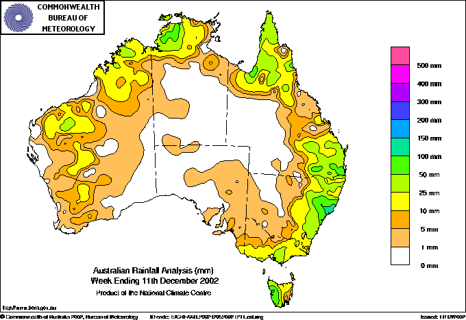
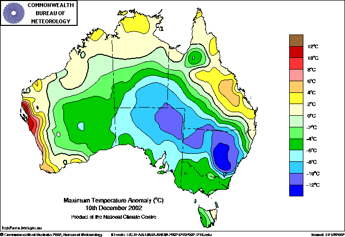
The best rain since April drenched much of the NSW and SE Qld seabord today. The map above shows rain for the week ended 9am Wednesday, but most of the rain in NSW and southern Queensland fell during the last 48 hours. The map below shows the maximum temperature departure from normal, with a large swathe of country experiencing top temperatures between 8 and 17° below average BoM

The unexpected development of a significant upper low gave eastern NSW widespread moderate to heavy rain today. Bushfires were extinguished or substantially retarded, and some of the state's driest areas received heavy, soaking rain. While the rain is not enough to be considered drought-breaking, it will give many farmers the go-ahead to plant summer crops.

An upper trough and cold pool moved in behind a surface trough lying across the state's northeast late Monday and progressed slowly northeast during today, developing into a closed upper low over southern Queensland by Wednesday morning. Northerlies ahead of the surface and upper trough systems over the past few days have brought a plentiful supply of moisture down into eastern NSW and SE Qld. Meantime, a substantial jet stream over southern Queensland produced respectable vertical ascent over NE NSW/SE Qld, enhancing the broadscale convergence in the troughs and developing low.

A broad area of rain developed on Monday evening over the Southern and Central Tablelands under the upper trough and extended to the South Coast by early this morning. During the morning it moved very slowly northwards, stalling during the afternoon over the Hunter and Central Coast. It stayed in this general area for 24 hours, producing soaking rains upwards of 100mm across much of the drought-stricken Hunter Valley. Most of the rain for this event fell during the 24 hours to 9am Wednesday, (where a gratifyingly long list of rainfall totals exceeding 50mm can be found). December daily rainfall records were broken at Quirindi, Woolbrook, Murrurundi, Cessnock (Nulkaba), Paterson (Tocal), Lostock Dam, and Peats Ridge, and probably at other locations yet to report. The records at Quirindi and Murrurundi had stood for 116 and 128 years respectively. The heavy rain in the Manning has led to the lifting of water restrictions from Crowdy Head to Forster/Tuncurry, while soaking rains in the Hunter Valley wine regions have saved the 2003 vintage from very low yields.

Soon after sunrise this morning, a line of storms developed along the surface troughline from Newcastle to around St George in central southern Queensland. The line intensified and broadened as it moved northeast with the surface trough over the next 12 hours, bringing some heavy short-duration falls to the North and Mid North Coasts and Northern Tablelands and Slopes (see the high short-duration rainfall box below). The highest falls in the nation were 168mm at Upper Chichester, 155.8 at Stroud, 154.6 at Laurieton and 154.2 at Upper Allyn, which had the benefit of both the thunderstorms and the prolonged period under the stalled rainband, as well as orographic enhancement from downwind mountains. Strong winds and a possible tornado accompanied the storms at Ballina, where at least 5 buildings including the fire station were unroofed and damage was caused to trees and small structures. Damage was also reported from Lismore, Murwillumbah and Nimbin, and the Lismore - Nimbin Road was closed by fallen trees.

The day was unusually cold under the extensive cloudband accompanying the upper trough, and particularly so in the persistent rainband. Sydney's top temperature of 16.1° was the coldest December day since 1924, while Katoomba only made it to 8.5. In the Central West, Trangie, Peak Hill, Parkes and Grenfell all recorded tops of around 15°, which is between 15 and 17 below normal.

The storm band that moved across NE NSW during the day began producing torrential rains over the Darling Downs mid afternoon with Miles reporting 15.2mm in 8 minutes, Oakey 11.4 in 7 minutes and Stanthorpe 9.4 in 5 minutes. Strong wind caused damage to a house, sheds and trees at Tara, northwest of Toowoomba. By 5pm a slow-moving line of storms extended from off the Gold Coast, across Brisbane to the Sunshine Coast hinterland. Brisbane Airport recorded a wind gust of 121km/h and received 25.6mm of rain in 10 minutes while Brisbane City had 37.6mm in 21 minutes. Most locations in the metropolitan area recorded between 30 and 60mm in all from the storm. The combination of lightning strikes, wind and rain brought down trees and powerlines across Brisbane and the Gold Coast, blacking out aover 100,000 properties and delaying electric train services. Local flooding in Brisbane caused peak-hour traffic chaos and flooded shops in the city's Queen Street Mall. Homes were damaged at Mitchelton in Brisbane's north, and Nerang, Burleigh and Labrador on the Gold Coast.

At one point during the early evening, the line of storms stretched over 600km from off the NSW North Coast to west of Rockhampton Qld. North of Brisbane at Gympie, where wind gusted to 91km/h, 22 homes and four businesses suffered roof damage, while one house lost its whole verandah. Inland, extensive damage was caused in the Biloela and Thangool area, with a house and many units of a motel unroofed in Thangool, trees and powerlines down, and the Burnett Highway that passes through the two towns closed for 6 hours by fallen powerlines. The Insurance Council expects the damage bill from the storm event to reach at least $1.5m.

NEWSBITS: While the cold pool was giving rain and storms to eastern parts of NSW and Queensland, the cool dry air under cloudless skies in its wake produced a cold December morning in western NSW, SW Qld and eastern SA. Birdsville Qld had their coldest December morning in 45 years of computerised records when the mercury dropped to 10.9°, while Leigh Creek, north of Port Augusta SA, recorded 9.1, its lowest in a shorter 12 year record.

National weather extremes for today
Data provided by the Bureau of Meteorology
Last updated at 08:37 UTC on 11/12/02

Quality control note: Data is complete, and has been visually checked by AWN for gross errors. Less obvious errors may remain. See Explanation of Extremes Pages for more information
Records set this day (previous record and years of computerised record shown in brackets):
Lowest daily minimum temperature for December:
Leigh Creek AP SA: 9.1 (9.2, 12)
Birdsville Police Stn Qld: 10.9 (11.0, 45)

Todays highest rainfall totals for the 24 hours to 9am. It includes the top 5 totals received, and/or all reported falls of 50mm or more.

84.0 DAMPIER DOWNS W Kimberley WA
83.0 MACLEANS BRIDGE Brisbane/SE Coast QLD
78.0 TAROME Brisbane/SE Coast QLD
76.0 SOUTHWOOD Darling Downs W QLD
75.0 AMBERLEY AMO Brisbane/SE Coast QLD

WESTERN AUSTRALIA
    W Kimberley
84.0 DAMPIER DOWNS

QUEENSLAND
    Central Highlands
72.4 THE SANDSTONE
    Brisbane/SE Coast
83.0 MACLEANS BRIDGE
78.0 TAROME
75.0 AMBERLEY AMO
66.0 GREENBANK THOMPSON ROAD
63.6 MULGOWIE
55.6 HARRISVILLE POST OFFICE
52.0 OXENFORD (OBERON WAY)
51.6 NERANG GILSTON RD
    Darling Downs E
70.0 TRAIGHLI
57.8 CAMBOOYA POST OFFICE
56.0 TARA SHIRE COUNCIL
53.0 WOODSPRING
52.0 TOOWOOMBA AIRPORT
52.0 BOWENVILLE
    Darling Downs W
76.0 SOUTHWOOD
56.8 TALWOOD STATE SCHOOL

NEW SOUTH WALES
    MidNorth Coast S
51.2 PORT MACQUARIE (HILL STREET)

High rainfall for periods of 6 hours or less.


NORTHERN TERRITORY
    N Rivers
MIDDLE POINT AWS
9.6mm in 12 min to 16:12 48.0mm/h
16.2mm in 48 min to 17:00 20.2mm/h
25.8mm in 1 hr to 17:00 25.8mm/h
34.0mm in 3 hr to 18:00 11.3mm/h
    Roper-McArthur
BORROLOOLA
7.8mm in 36 min to 14:00 13.0mm/h
    Darwin-Daly
TINDAL RAAF
11.6mm in 30 min to 23:30 23.2mm/h
25.2mm in 1 hr to 23:30 25.2mm/h

QUEENSLAND
    Gulf Country
NORMANTON AIRPORT
21.0mm in 31 min to 10:00 40.6mm/h
22.4mm in 1 hr to 10:00 22.4mm/h
    Wide Bay/Burnett
BUNDABERG AERO
9.6mm in 11 min to 20:28 52.4mm/h
12.8mm in 32 min to 21:00 24.0mm/h
23.0mm in 3 hr to 21:00 7.7mm/h
    Brisbane/SE Coast
CAPE MORETON LIGHTHOUSE
19.0mm in 13 min to 18:11 87.7mm/h
10.4mm in 14 min to 18:25 44.6mm/h
40.0mm in 3 hr to 21:00 13.3mm/h
DOUBLE ISLAND POINT LIGHTHOUSE
15.0mm in 3 hr to 21:00 5.0mm/h
UNIVERSITY OF QUEENSLAND GATTON
34.0mm in 3 hr to 18:00 11.3mm/h
GYMPIE
10.0mm in 6 min to 18:06 100.0mm/h
7.6mm in 8 min to 18:14 57.0mm/h
20.2mm in 1 hr to 19:00 20.2mm/h
31.0mm in 3 hr to 21:00 10.3mm/h
MARYBOROUGH
24.0mm in 3 hr to 21:00 8.0mm/h
NAMBOUR DPI
15.0mm in 3 hr to 06:00 5.0mm/h
7.6mm in 12 min to 18:00 38.0mm/h
18.2mm in 1 hr to 19:00 18.2mm/h
25.0mm in 3 hr to 21:00 8.3mm/h
BEERBURRUM FOREST STN
4.6mm in 12 min to 17:12 23.0mm/h
16.6mm in 48 min to 18:00 20.8mm/h
21.2mm in 1 hr to 18:00 21.2mm/h
21.0mm in 3 hr to 18:00 7.0mm/h
HERVEY BAY AIRPORT
27.6mm in 54 min to 21:00 30.7mm/h
31.0mm in 3 hr to 21:00 10.3mm/h
10.8mm in 1 hr to 22:00 10.8mm/h
TOOLARA (KELLY)
7.4mm in 38 min to 19:00 11.7mm/h
15.0mm in 3 hr to 21:00 5.0mm/h
JIMNA FORESTRY
29.0mm in 3 hr to 18:00 9.7mm/h
COOLANGATTA AIRPORT
7.2mm in 15 min to 17:00 28.8mm/h
GOLD COAST SEAWAY
16.0mm in 8 min to 16:43 120.0mm/h
7.6mm in 17 min to 17:00 26.8mm/h
23.6mm in 1 hr to 17:00 23.6mm/h
25.0mm in 1 hr to 17:30 25.0mm/h
27.0mm in 3 hr to 18:00 9.0mm/h
BRISBANE AERO
11.4mm in 30 min to 06:30 22.8mm/h
13.2mm in 1 hr to 06:30 13.2mm/h
12.2mm in 1 hr to 07:00 12.2mm/h
11.2mm in 5 min to 16:59 134.4mm/h
14.4mm in 5 min to 17:04 172.8mm/h
8.8mm in 12 min to 17:16 44.0mm/h
44.6mm in 1 hr to 17:30 44.6mm/h
46.0mm in 3 hr to 18:00 15.3mm/h
MAROOCHYDORE AERO
12.2mm in 14 min to 18:30 52.3mm/h
12.2mm in 1 hr to 18:30 12.2mm/h
17.8mm in 1 hr to 19:00 17.8mm/h
24.0mm in 3 hr to 21:00 8.0mm/h
TEWANTIN RSL PARK
13.2mm in 32 min to 19:00 24.8mm/h
26.0mm in 3 hr to 21:00 8.7mm/h
BRISBANE
15.0mm in 3 hr to 06:00 5.0mm/h
37.6mm in 21 min to 17:00 107.4mm/h
40.6mm in 1 hr to 17:00 40.6mm/h
43.0mm in 1 hr to 17:30 43.0mm/h
44.0mm in 3 hr to 18:00 14.7mm/h
KINGAROY AIRPORT
4.8mm in 12 min to 17:00 24.0mm/h
13.8mm in 1 hr to 17:00 13.8mm/h
16.0mm in 3 hr to 18:00 5.3mm/h
    Darling Downs E
INGLEWOOD FOREST
11.6mm in 31 min to 14:00 22.5mm/h
12.2mm in 1 hr to 14:00 12.2mm/h
STANTHORPE (GRANITE BELT HRS)
9.4mm in 5 min to 14:39 112.8mm/h
15.0mm in 1 hr to 15:00 15.0mm/h
OAKEY AERO
11.6mm in 1 hr to 01:00 11.6mm/h
18.0mm in 3 hr to 03:00 6.0mm/h
11.4mm in 7 min to 14:57 97.7mm/h
WARWICK
9.0mm in 11 min to 15:00 49.1mm/h
TOOWOOMBA AIRPORT
10.2mm in 29 min to 01:00 21.1mm/h
13.0mm in 1 hr to 01:00 13.0mm/h
18.0mm in 3 hr to 03:00 6.0mm/h
    Darling Downs W
MILES CONSTANCE STREET
4.2mm in 3 min to 14:30 84.0mm/h
6.2mm in 3 min to 14:33 124.0mm/h
4.8mm in 2 min to 14:35 144.0mm/h
11.2mm in 16 min to 14:51 42.0mm/h
29.0mm in 3 hr to 15:00 9.7mm/h

NEW SOUTH WALES
    NW Slopes S
WOOLBROOK (DANGLEMAH ROAD)
34.0mm in 6 hr to 15:00 5.7mm/h
    N Tablelands W
GLEN INNES AIRPORT AWS
18.0mm in 3 hr to 15:00 6.0mm/h
    North Coast
YAMBA PILOT STATION
24.0mm in 3 hr to 18:00 8.0mm/h
BALLINA AIRPORT AWS
17.4mm in 17 min to 17:24 61.4mm/h
8.6mm in 36 min to 18:00 14.3mm/h
29.4mm in 1 hr to 18:00 29.4mm/h
CASINO AIRPORT AWS
7.0mm in 33 min to 17:30 12.7mm/h
EVANS HEAD RAAF BOMBING RANGE
20.0mm in 3 hr to 18:00 6.7mm/h
LISMORE AIRPORT AWS
24.0mm in 3 hr to 18:00 8.0mm/h
    MidNorth Coast N
KEMPSEY AIRPORT AWS
12.8mm in 18 min to 14:30 42.7mm/h
13.4mm in 1 hr to 14:30 13.4mm/h
14.4mm in 1 hr to 15:00 14.4mm/h
    MidNorth Coast S
FORSTER BEACH CARAVAN PARK
32.0mm in 6 hr to 15:00 5.3mm/h
TAREE AIRPORT AWS
11.8mm in 1 hr to 14:00 11.8mm/h
15.6mm in 1 hr to 14:30 15.6mm/h
25.0mm in 3 hr to 15:00 8.3mm/h
11.2mm in 30 min to 23:30 22.4mm/h
16.6mm in 1 hr to 23:30 16.6mm/h
    Hunter Valley
MURRURUNDI POST OFFICE
31.0mm in 3 hr to 15:00 10.3mm/h
NELSON BAY (NELSON HEAD)
37.0mm in 6 hr to 15:00 6.2mm/h
NEWCASTLE NOBBYS SIGNAL STATION
11.2mm in 1 hr to 11:30 11.2mm/h
24.0mm in 3 hr to 15:00 8.0mm/h
WILLIAMTOWN RAAF
18.0mm in 3 hr to 12:00 6.0mm/h
18.0mm in 3 hr to 15:00 6.0mm/h
GOSFORD (NARARA RESEARCH STATION) AWS
10.2mm in 1 hr to 14:00 10.2mm/h
10.0mm in 1 hr to 14:30 10.0mm/h
25.0mm in 3 hr to 15:00 8.3mm/h
19.0mm in 3 hr to 18:00 6.3mm/h
CESSNOCK (NULKABA)
34.0mm in 6 hr to 15:00 5.7mm/h
PATERSON (TOCAL)
18.0mm in 3 hr to 12:00 6.0mm/h
11.2mm in 1 hr to 12:30 11.2mm/h
37.4mm in 2 hr 30 min to 15:00 15.0mm/h
49.8mm in 5 hr to 17:30 10.0mm/h
10.6mm in 1 hr to 18:00 10.6mm/h
19.0mm in 3 hr to 18:00 6.3mm/h
11.8mm in 1 hr to 18:30 11.8mm/h
CESSNOCK AIRPORT AWS
22.0mm in 3 hr to 15:00 7.3mm/h
NORAH HEAD LIGHTHOUSE
18.0mm in 3 hr to 12:00 6.0mm/h
16.0mm in 3 hr to 15:00 5.3mm/h
PEATS RIDGE (WARATAH ROAD)
30.0mm in 6 hr to 15:00 5.0mm/h
SCONE AIRPORT AWS
21.0mm in 3 hr to 15:00 7.0mm/h
17.0mm in 3 hr to 18:00 5.7mm/h
NORAH HEAD AWS
11.4mm in 1 hr to 13:30 11.4mm/h
20.0mm in 3 hr to 15:00 6.7mm/h
18.0mm in 3 hr to 21:00 6.0mm/h
SINGLETON WATER BOARD
36.0mm in 6 hr to 15:00 6.0mm/h
MANGROVE MOUNTAIN AWS
12.2mm in 1 hr to 22:30 12.2mm/h
11.6mm in 1 hr to 23:00 11.6mm/h
MAITLAND VISITORS CENTRE
46.0mm in 6 hr to 15:00 7.7mm/h
NEWCASTLE UNIVERSITY
44.0mm in 6 hr to 15:00 7.3mm/h
    C Tablelands N
NULLO MOUNTAIN AWS
19.0mm in 3 hr to 15:00 6.3mm/h
    CW Slopes N
COONABARABRAN (NAMOI STREET)
28.0mm in 3 hr to 09:00 9.3mm/h
    Illawarra
BELLAMBI AWS
4.6mm in 13 min to 20:13 21.2mm/h

ISLANDS
    Islands
CAPE FOURCROY
11.0mm in 1 hr to 18:00 11.0mm/h
21.0mm in 3 hr to 18:00 7.0mm/h
10.0mm in 1 hr to 19:00 10.0mm/h
21.0mm in 2 hr to 19:00 10.5mm/h

Todays highest & lowest temperatures

Maximum Minimum
43.4 NYANG STATION W Gascoyne WA
43.0 MARDIE W Pilbara WA
43.0 PANNAWONICA W Pilbara WA
43.0 SHARK BAY AIRPORT W Gascoyne WA
42.9 CARNARVON AIRPORT W Gascoyne WA
29.5 MARBLE BAR COMPARISON E Pilbara WA
29.5 ALYANGULA POLICE Arnhem NT
29.2 CENTRE ISLAND Roper-McArthur NT
29.0 MCCLUER ISLAND Darwin-Daly NT
29.0 NARAWILLI Arnhem NT
29.0 GROOTE EYLANDT AIRPORT AWS Arnhem NT
29.0 WAVE HILL Victoria NT
29.0 ELLIOTT Barkly NT
29.0 MARBLE BAR E Pilbara WA
5.6 MOUNT READ W Coast TAS
7.0 THREDBO (CRACKENBACK STATION) AWS Snowy Mtns NSW
7.2 HARTZ MOUNTAIN(KEOGHS PIMPLE) Southeast TAS
7.5 MT HOTHAM Upper NE VIC
7.6 MOUNT WELLINGTON Southeast TAS
-3.0 MOUNT BULLER Upper NE VIC
-2.5 MT HOTHAM Upper NE VIC
-1.8 MOUNT WELLINGTON Southeast TAS
-1.8 LIAWENEE AWS Central Plateau TAS
-1.7 FALLS CREEK Upper NE VIC

Todays greatest temperature variations from normal

Maximum Minimum
+13.7   42.9 CARNARVON AIRPORT W Gascoyne WA
+12.6   41.5 DENHAM W Gascoyne WA
+11.0   42.0 KALBARRI Central West WA
+9.3   36.5 LANCELIN Lower West WA
+9.0   38.5 GERALDTON AIRPORT Central West WA
+6.8   28.0 GASCOYNE JUNCTION W Gascoyne WA
+5.3   22.7 KALBARRI Central West WA
+5.1   21.5 ENEABBA Central West WA
+4.9   20.5 JURIEN Lower West WA
+4.6   29.0 WAVE HILL Victoria NT
+4.6   29.0 ELLIOTT Barkly NT
+4.6   23.0 GYMPIE Brisbane/SE Coast QLD
+4.6   21.0 KEMPSEY (WIDE STREET) MidNorth Coast N NSW
-16.9   15.0 TRANGIE RESEARCH STATION AWS CW Plains N NSW
-16.3   15.1 PEAK HILL POST OFFICE CW Plains S NSW
-15.6   15.0 PARKES (MACARTHUR STREET) CW Slopes S NSW
-15.1   14.9 GRENFELL (QUONDONG RD) SW Slopes N NSW
-14.8   16.9 CONDOBOLIN AG RESEARCH STN CW Plains S NSW
-11.5   10.9 BIRDSVILLE POLICE STATION Channel Country QLD
-9.8   9.1 LEIGH CREEK AIRPORT NE Pastoral SA
-9.3   11.3 KULGERA Alice Springs NT
-8.9   8.1 BROKEN HILL (PATTON STREET) Lower Darling NSW
-8.7   12.4 OODNADATTA AIRPORT NE Pastoral SA

Highest wind gusts above 89km/h or mean wind above 62km/h (gale force). Wind direction and mean windspeed shown in brackets.

RUNDLE ISLAND Wide Bay/Burnett QLD: 70 (360/ 63 ) at 17:00
GYMPIE Brisbane/SE Coast QLD: 93 (240/ 50 ) at 18:06
TOOLARA (KELLY) Brisbane/SE Coast QLD: 91 (290/ 32 ) at 18:21
BRISBANE AERO Brisbane/SE Coast QLD: 121 (260/ 80 ) at 16:59
INNER RECIPROCAL MARKER Brisbane/SE Coast QLD: 95 (250/ 52 ) at 17:06
OAKEY AERO Darling Downs E QLD: 96 (310/ 43 ) at 14:57
NORAH HEAD AWS Hunter Valley NSW: 78 (170/ 65 ) at 14:30
WILSONS PROMONTORY LIGHTHOUSE W Gippsland VIC: 69 (240/ 63 ) at 16:00
MAATSUYKER ISLAND LIGHTHOUSE Southeast TAS: 102 (310/ 83 ) at 13:14
MOUNT WELLINGTON Southeast TAS: 100 (250/ 80 ) at 15:00

Other extremes

..