weather reports
The Australian Weather News 3-hourly weather reports give possibly the most comprehensive and detailed view of current Australian weather available. Colour-coding and symbols pack an enormous amount of information into a small space, but allow you to home in on what's interesting. The reports use the traditional table format, with one row per station report, but colour is used to highlight significant parts of each observation while symbols give full information about cloud, weather and even the barograph trace. It's in a form that is easy to understand but doesn't dumb down the information so as to make it fit the page! There's a description of each column of information below.
The reports are based on the synoptic observations -- or obs -- sent in every three hours by hundreds of professional and volunteer observers around the country. They are supplemented by an expanding network of automatic weather stations. However, the reports from manned stations are considerably more detailed than the hourly automatic weather station reports, giving visual observations of cloud types and amounts, descriptions of present and past weather and measurements of visibility, as well as occasional comments on the weather. They provide the main surface input for the Bureau of Meteorology's weather maps and analysis, and for the global computer forecasting models run by many countries.
To pack all this information onto a computer screen in a form that mere mortals can understand is something of a challenge. About 7,000 obs are received each day from airports, lighthouses, post offices, remote cattle stations and country town backyards. While temperature, barometric pressure, wind, humidity and rainfall can be summarised in figures, it is the visual observations of the human observers that are often the most interesting but most difficult to represent. For example, how do you fit this in a concise report: "Over the past few hours it was cloudy with a few sunny breaks at first, but then thunderstorms developed but have cleared away to intermittent moderate rain now. The sky is a mix of thick nimbostratus with some very low-based large cumulus moving in from the west."
I have decided to use the standard international weather symbols,
the same as used on the AWN synoptic charts (and on professional synoptic
analysis charts around the world). Many of the weather symbols are
pretty self-explanatory. ![]() looks
like rain, and
looks
like rain, and ![]() looks
like heavier rain!
looks
like heavier rain! ![]() is
a thunderstorm,
is
a thunderstorm, ![]() is
snow,
is
snow, ![]() drizzle,
drizzle, ![]() fog,
fog, ![]() cumulonimbus
cloud, and so on. However, observers can use 99 symbols to describe
just the present weather alone, so you'll find a few less intuitive
ones, such as
cumulonimbus
cloud, and so on. However, observers can use 99 symbols to describe
just the present weather alone, so you'll find a few less intuitive
ones, such as ![]() and
and ![]() .
Happily, you can refer to cheat cards to see what the more obscure
symbols mean -- just click on the column heading to bring it up in
a separate screen.
.
Happily, you can refer to cheat cards to see what the more obscure
symbols mean -- just click on the column heading to bring it up in
a separate screen.
The same information is available in three formats, depending on how you want to use it.
-
The state weather reports give all observations for each state for each observation time. Click on latest for the most recent obs time, or go the the archive for all 3-hourly obs from the past week. These are good for getting a snapshot of the weather at any one time.
-
The district full-day reports gradually accumulate through the day all the observations for each weather station in the district into one table. These are good for seeing the progress of the weather over time. There are also grouped reports of capital city and regional centres available. Again, there is a one-week archive for each district.
-
Finally, the National Severe Weather Summary lists only those observations which show that significant weather is happening. It is updated about every 15 minutes, and can get quite colourful when the weather gets wild.
The format for all reports is basically the same, and tries to reduce the problems that some users with small screens will have by dividing the information into two, with the station names down the middle. To the left of the station names are the basic daily measures of maximum and minimum temperature and rainfall. Where averages are available, the departure from average is shown, while rainfall is often given over two different periods such as 3 and 6 hours. To the right of the station name are the instantaneous observations made by the observer in the 10 minutes leading up to obs time -- cloud, weather and instrument readings.
I hope you have as much fun using the tables as I've had creating them. If they seem a bit colourless today, just wait until the weather gets interesting!
Column heading
Description
Max
The maximum temperature over various periods. At 9am, it is the official 24-hour maximum. At 3pm, it is the maximum since 9am. AWS, and some manned stations, also report a maximum at midnight which is for the previous 24 hours. When the temperature reaches 43 degrees, the cell turns red.
The minimum temperature over various periods. At 9am, it is the official 24-hour minimum. AWS and some manned stations also report a minimum at midday which is for the previous 24 hours. When the temperature reaches -6, it turns blue, probably along with the inhabitants.
The variation from normal max or min temperature, where the station has been operating long enough to have credible averages. These columns make great use of colour coding to show readings both above and below normal for both max and min temps.
4 to 7.9 degrees above normal |
4 to 7.9 degrees below normal |
8 to 11.9 degrees above normal |
8 to 11.9 degrees below normal |
12 degrees or more above normal |
12 degrees or more below normal |
The grass or terrestrial minimum temperature overnight. This is recorded by a minimum thermometer placed so that it is just touching the top of short-clipped grass, and gives a more accurate indication of the occurrence of frost than the standard minimum temperature thermometer which is exposed in a Stevenson Screen about 1m above ground level. On clear, calm winter nights, there can be some astounding differences between these two thermometers. This also turns blue when it reaches -6.
When rain has fallen, the observer often records the amounts for two different periods, so 2/24 0.6/18 indicates 2mm for the past 24 hours and 0.6mm over the past 18 hours. Tr = a trace of rain (less than 0.1mm, but enough to empty out of the gauge). The cells turn tasteful shades of green when the rainfall rates reach the following levels:
2.5 to 4.9mm/hour |
5.0 to 9.9mm/hour |
10.0mm/hour or more |
The official name of the station
So, for example, 0331=31 March
The clock time the observation was made. The standard synoptic hours in Australia are 0000, 0300, 0600, 0900, 1200, 1500, 1800 and 2100 in whatever local flavour of time is current, whether daylight saving or standard time. Yes, Hilda, this means that observations are not synchronous across the country. You will notice that some stations (mostly AWS) make some intermediate hour observations as well. These are taken so as to synchronise with the global observing network at 00, 03, 06, etc UTC.
Time for some symbols! For a full explanation of them, click here, or click the column heading in the report. For more information on clouds, go to the AWN Visual Observation page.
If you like clouds you will love the detail in this box. There are
six items of information. From the left:
1.![]()
![]()
![]()
![]() ...
... ![]() show
increasing amounts of total cloud cover. The circle is like the dome
of the sky above you, and the cloud amount is measured in eighths (or
octas) of the sky covered. If the observer can't ascertain the cloud
cover, you get an
show
increasing amounts of total cloud cover. The circle is like the dome
of the sky above you, and the cloud amount is measured in eighths (or
octas) of the sky covered. If the observer can't ascertain the cloud
cover, you get an ![]()
2. A second cloud amount symbol tells you how much of the sky
is covered by the lowest type of cloud (usually low level cloud, but
sometimes middle level cloud).
3. Next to the low cloud amount symbol is a low cloud type symbol,
e.g. ![]() . There are nine
possibilities, and they tell you a lot about the character of the weather
at the station. Click the column heading for the full story.
. There are nine
possibilities, and they tell you a lot about the character of the weather
at the station. Click the column heading for the full story.
4. Next comes two more pieces of information about the lowest cloud:
the height of its base in hundreds of metres and the direction it is
moving from. So 3/SW means a cloud base of
300m (1000 feet) and the cloud's moving from the southwest, and 15/NE
is 1,500m or 1.5km from the northeast. When the cloud base is 300m or
lower, it turns a dirty shade
of grey. Cumulonimbus (storm clouds) are colour coded: ![]() and
and ![]()
5. Next is the predominant type of middle level cloud. There are some
exotic beasts here, the most useful of which is ![]() altocumulus
castellanus, a remarkably accurate harbinger of thunderstorms.
altocumulus
castellanus, a remarkably accurate harbinger of thunderstorms.
6. Finally comes the predominant type of high cloud and what it's doing.
As with middle level cloud, there are nine types and nine symbols.
The direction is given in degrees from north and the
speed in km/h. So:
090/15 = easterly at 15km/h (i.e. the wind is blowing from the
east)
180/45 = southerly 45km/h
270/30 = westerly 30km/h
360/02 = northerly at 2km/h (north is 360° not 0° so that it
won't confuse with 0/0 which is, of course, Calm.
The wind cell is colour coded to highlight standard wind strengths according to the Beaufort Scale:
41 to 62km/h, or strong wind speeds |
63 to 89km/h, or gale force |
90km/h or above, or storm force |
Why use degrees instead of the more common N, NNE, NE etc? Simply because 36 separations of measurement give more accuracy than 16, and allow you to see more clearly any gradual backing or veering of the wind.
The standard air temperature measurement of a dry thermometer bulb exposed in a Stevenson Screen.
The dew point temperature is a standard measure of humidity. It is the temperature to which you would have to cool the air to make it fully saturated.
A more popular, but less accurate, measure of humidity. It's the percentage of the amount of moisture present in the air at the present temperature relative to the amount that would be present if the air were saturated.
Three pieces of information:
1. The barometer reading in hectopascals (hPa), aka millibars, converted
to sea level.
2. The observer's interpretation of the shape of the barograph (recording
barometer) trace on the chart over the past 3 hours.
3. The change, in hPa over the past 3 hours.
So, ![]() 3.4 = falling steadily
by 3.4hPa over the past 3 hours, and
3.4 = falling steadily
by 3.4hPa over the past 3 hours, and
![]() 2.4 = falling
then rising a bit, but overall a fall of 2.4hPa over the past
3 hours. All the symbols are shown here.
2.4 = falling
then rising a bit, but overall a fall of 2.4hPa over the past
3 hours. All the symbols are shown here.
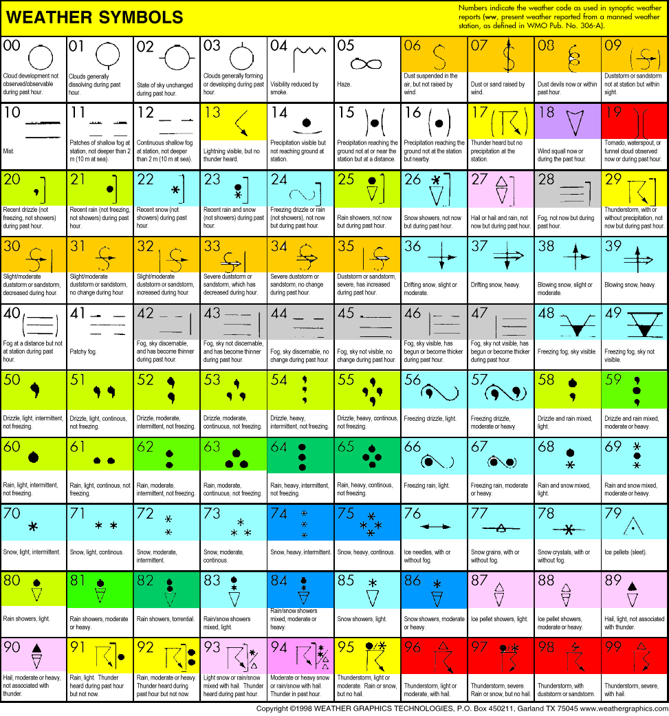
There is a huge amount of information in these three symbols, which are pretty easy to understand. Click here for present weather symbols, and here for past weather symbols to get full details. You can also click on the column headings in the report. However, the important symbols (about 90% of them) are colour coded with this simple colour scheme:
Light green for light rain or showers, moderate green for moderate, dark green for heavy. |
|
Yellow for lightning or thunderstorms, red for present thunderstorms with hail, severe storms and tornadoes or waterspouts. |
|
Light mauve for hail, dark mauve if it's heavy and associated with thunderstorms |
|
Light blue for snow, sleet, freezing fog or rain, or any solid precipitation or blowing snow; dark blue if it's heavy |
|
Tan for dust in the air, dust storms, dust devils |
|
A murky grey for fog |
|
Purple for wind squalls |
All up, there are 99 symbols for present weather (the weather at the
time or shortly before the observation), and 9 symbols for past weather
(since the last observation). What's more, the observer can use two
symbols for past weather to give a more complete picture. So past weather
symbols of ![]()
![]() tell
us that there's been a thunderstorm, with cloud varying above and below
half cover since the last observation.
tell
us that there's been a thunderstorm, with cloud varying above and below
half cover since the last observation.
The present weather symbols convey many subtle shades of meaning.
For example:
![]() = dust in
the air, but not raised locally by the wind
= dust in
the air, but not raised locally by the wind
![]() =
dust, sand (or sea spray -- that's the loopy
symbol) raised locally by the wind
=
dust, sand (or sea spray -- that's the loopy
symbol) raised locally by the wind
![]() =
dust devils (willy willies) raising dust
=
dust devils (willy willies) raising dust
![]() =
a dust or sand storm within
sight but not at the station
=
a dust or sand storm within
sight but not at the station
and then there are 6 symbols for full-on dust storms, culminating in ![]() ,
severe dust storm increasing!
,
severe dust storm increasing!
Add to this 14 types of fog, 17 types of rain (not including showers),
and numerous permutations of thunderstorms, hail, tornadoes, squalls,
ice needles and pellets, snow grains and crystals, and you have a Chamber
of Weather Horrors capable of covering every eventuality.
Visibility. The greatest distance at which clearly defined objects (e.g. power transmission masts) can be identified. This is given in kilometres and tenths. Colour coding is used to show progressive levels of murk:
From 4km down to 1km |
Less than 1km but more than 200m (fog) |
200m or less (dense fog) |
This contains any plain text message sent in by the observer with the obs. Some are quite chatty, and there is often additional information here about notable weather events. There's also the odd mention of broken thermometers, missing supplies, errors in earlier observations and other administrative trivia. AWSs are less chatty, but do send in their rainfall for the hour leading up to the observation thus: HR006=6mm.