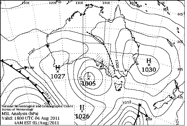
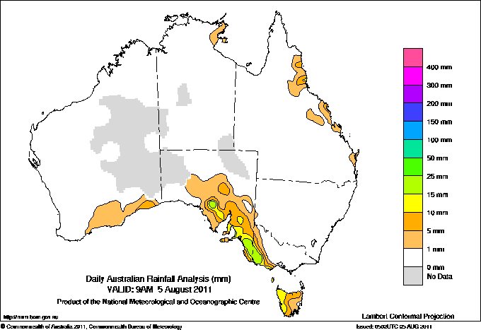
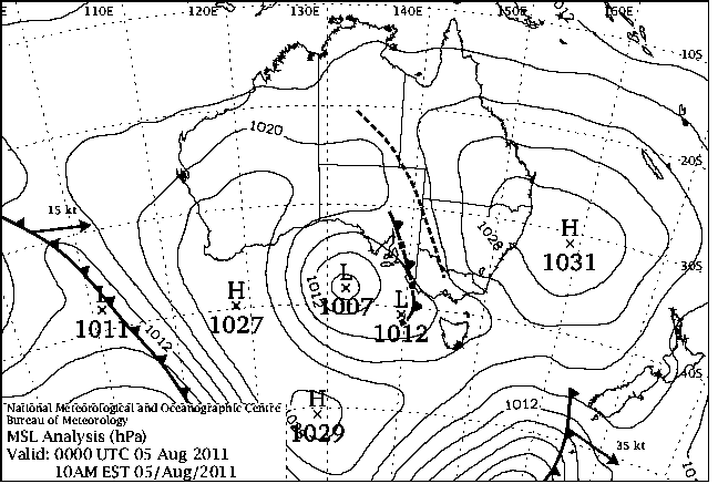
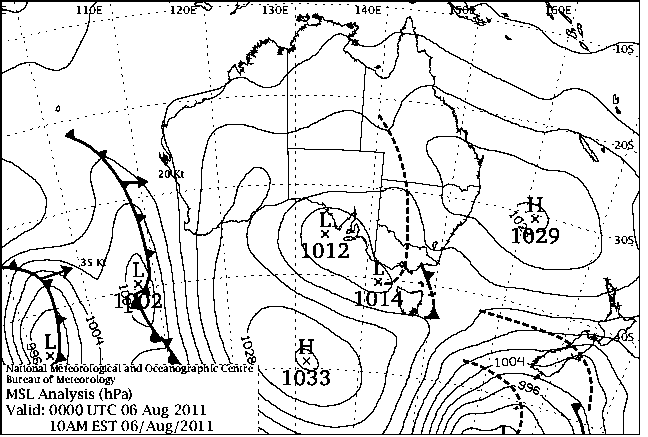
|
For notes on how to interpret
the data and quality control issues, see Daily Weather Summary Help.
**S** and **W** precede data flagged by the Bureau as suspicious or wrong
Data is as received at 01:48EST, 26/05/2012.
|
|
| |
Max
°
C |
+/- norm
°
C |
Min
°
C |
+/- norm
°
C |
Grass Min
°
C |
Rain to 9am mm |
Evaporation to 9am mm |
Sunshine hours |
Wind Run to 9am km (24-hour average km/h) |
Maximum Gust km/h / hour of occurrence |
| GERALDTON AIRPORT |
18.0 |
-2.0 |
3.5 |
-5.4 |
3.0 |
0.0 |
-- |
-- |
312 (13.0) |
39/11 |
| PERTH AIRPORT |
16.5 |
-1.9 |
4.6 |
-3.4 |
2.8 |
0.0 |
1.4 |
9.8 |
257 (10.7) |
41/13 |
| ALBANY AIRPORT |
14.6 |
-1.5 |
6.0 |
-1.5 |
4.0 |
0.0 |
1.0 |
4.5 |
221 ( 9.2) |
22/15 |
| BUNBURY |
16.3 |
-1.1 |
2.2 |
-5.2 |
-- |
0.0 |
-- |
-- |
149 ( 6.2) |
28/09 |
| MANDURAH |
17.1 |
-- |
7.6 |
-- |
-- |
0.0 |
-- |
-- |
191 ( 8.0) |
30/13 |
| DARWIN AIRPORT |
31.2 |
-0.1 |
19.6 |
-0.8 |
18.2 |
0.0 |
7.8 |
9.8 |
402 (16.8) |
41/10 |
| ALICE SPRINGS AIRPORT |
22.8 |
+0.2 |
7.9 |
+1.9 |
5.6 |
0.0 |
6.2 |
10.4 |
358 (14.9) |
30/03 |
| WHYALLA AERO |
18.8 |
+0.3 |
9.7 |
+3.8 |
-- |
5.6 |
1.6 |
-- |
214 ( 8.9) |
39/15 |
| ADELAIDE (KENT TOWN) |
16.0 |
-0.6 |
9.5 |
+1.3 |
-- |
15.4 |
0.8 |
8.5 |
225 ( 9.4) |
41/13 |
| MOUNT GAMBIER AERO |
14.1 |
0.0 |
9.3 |
+3.8 |
5.6 |
9.2 |
1.8 |
2.5 |
461 (19.2) |
44/03 |
| MOUNT ISA AERO |
27.2 |
-0.1 |
5.1 |
-5.2 |
3.8 |
0.0 |
5.0 |
10.4 |
178 ( 7.4) |
35/06 |
| CAIRNS AERO |
25.2 |
-1.4 |
19.1 |
+1.7 |
17.2 |
1.2 |
6.4 |
3.0 |
507 (21.1) |
43/09 |
| TOWNSVILLE AERO |
26.0 |
0.0 |
15.9 |
+1.2 |
11.1 |
0.0 |
7.2 |
5.0 |
509 (21.2) |
57/13 |
| MACKAY M.O |
22.2 |
-0.4 |
16.6 |
+2.6 |
-- |
11.8 |
-- |
4.2 |
432 (18.0) |
46/10 |
| ROCKHAMPTON AERO |
22.6 |
-2.2 |
13.5 |
+2.8 |
12.0 |
0.0 |
4.0 |
-- |
397 (16.5) |
43/13 |
| BUNDABERG AERO |
22.6 |
-0.7 |
11.9 |
+1.0 |
-- |
0.0 |
-- |
-- |
418 (17.4) |
37/09 |
| NAMBOUR DPI |
20.0 |
-2.5 |
11.0 |
+2.9 |
-- |
0.6 |
-- |
-- |
-- |
-- |
| COOLANGATTA |
21.5 |
+0.2 |
10.0 |
-0.4 |
-- |
0.0 |
-- |
-- |
146 ( 6.1) |
30/12 |
| BRISBANE AERO |
21.2 |
-0.5 |
10.4 |
+0.8 |
9.0 |
0.0 |
3.6 |
4.8 |
293 (12.2) |
31/10 |
| TOOWOOMBA AIRPORT |
16.7 |
-1.8 |
9.6 |
+2.1 |
-- |
0.0 |
-- |
-- |
445 (18.5) |
37/15 |
| GUNNEDAH RESOURCE CENTRE |
21.9 |
+4.0 |
8.2 |
+2.4 |
1.9 |
0.0 |
3.2 |
-- |
64 ( 2.7) |
-- |
| COFFS HARBOUR MO |
22.1 |
+2.3 |
10.6 |
+2.4 |
6.7 |
0.0 |
2.6 |
10.0 |
406 (16.9) |
43/10 |
| PORT MACQUARIE AIRPORT AWS |
22.0 |
+1.8 |
4.0 |
-2.7 |
-- |
0.0 |
-- |
-- |
-- |
-- |
| WILLIAMTOWN RAAF |
22.9 |
+4.3 |
5.1 |
-1.7 |
-- |
0.2 |
-- |
-- |
79 ( 3.3) |
21/12 |
| GOSFORD (NARARA RESEARCH STATION) AWS |
23.7 |
+4.7 |
5.6 |
+0.3 |
-- |
0.0 |
-- |
-- |
30 ( 1.3) |
31/10 |
| ORANGE AGRICULTURAL INSTITUTE |
14.9 |
+4.0 |
3.8 |
+1.7 |
-3.2 |
0.0 |
2.8 |
9.5 |
-- |
-- |
| DUBBO AIRPORT AWS |
21.7 |
+4.3 |
4.9 |
+1.5 |
-- |
0.0 |
-- |
-- |
203 ( 8.5) |
48/10 |
| SYDNEY AIRPORT AMO |
25.2 |
+6.9 |
11.0 |
+2.9 |
6.4 |
0.0 |
5.4 |
10.1 |
347 (14.5) |
46/13 |
| RICHMOND RAAF |
23.4 |
+3.7 |
3.4 |
-1.0 |
-- |
0.0 |
-- |
-- |
67 ( 2.8) |
37/13 |
| BELLAMBI AWS |
23.6 |
+5.6 |
13.1 |
+2.7 |
-- |
0.0 |
-- |
-- |
305 (12.7) |
52/13 |
| CANBERRA AIRPORT |
19.0 |
+6.0 |
-1.0 |
-2.0 |
-2.0 |
0.0 |
-- |
-- |
-- |
-- |
| WAGGA WAGGA AMO |
21.4 |
+6.9 |
8.7 |
+5.1 |
5.0 |
0.0 |
4.2 |
9.1 |
366 (15.3) |
44/08 |
| ALBURY AIRPORT AWS |
20.7 |
+5.8 |
5.6 |
+1.9 |
-- |
0.0 |
-- |
-- |
234 ( 9.8) |
44/03 |
| MILDURA AIRPORT |
14.0 |
-3.2 |
10.7 |
+5.5 |
5.4 |
0.0 |
7.8 |
0.7 |
475 (19.8) |
34/14 |
| TATURA INST SUSTAINABLE AG |
18.8 |
+4.1 |
8.7 |
+4.8 |
4.5 |
0.0 |
4.2 |
-- |
390 (16.3) |
39/15 |
| BENDIGO AIRPORT |
15.5 |
+1.3 |
7.9 |
+5.3 |
-- |
0.0 |
-- |
-- |
255 (10.6) |
�
35/12 |
| MELBOURNE REGIONAL OFFICE |
18.4 |
+3.4 |
13.3 |
+6.6 |
9.8 |
0.0 |
2.4 |
-- |
-- |
-- |
| GEELONG AIRPORT |
-- |
-- |
-- |
-- |
-- |
-- |
-- |
-- |
-- |
-- |
| BALLARAT AERODROME |
10.8 |
-0.6 |
7.4 |
+3.7 |
-- |
0.0 |
-- |
-- |
332 (13.8) |
43/15 |
| LAUNCESTON (TI TREE BEND) |
17.0 |
+3.3 |
9.2 |
+5.6 |
-- |
6.2 |
-- |
-- |
-- |
21/14 |
| HOBART AIRPORT |
11.9 |
-1.6 |
9.0 |
+4.3 |
6.5 |
1.8 |
2.8 |
0.3 |
327 (13.6) |
26/14 |
| |
Max
°
C |
+/- norm
°
C |
Min
°
C |
+/- norm
°
C |
Grass Min
°
C |
Rain to 9am mm |
Evaporation to 9am mm |
Sunshine hours |
Wind Run to 9am km |
Maximum Gust km/h / hour of occurrence |
|
| Hottest |
| Highest maximum temperature> | Greatest variation above normal maximum |
Highest minimum temperature | Greatest variation above normal minimum |
32.7 WYNDHAM AERO N Kimberley WA
32.6 MIDDLE POINT AWS N Rivers NT
32.5 JABIRU AIRPORT N Rivers NT
32.3 BIDYADANGA W Kimberley WA
32.1 WYNDHAM N Kimberley WA
|
+9.7 : 24.4 GABO ISLAND LIGHTHOUSE E Gippsland VIC
+9.5 : 24.5 POINT HICKS (LIGHTHOUSE) E Gippsland VIC
+8.5 : 22.2 FLINDERS ISLAND AIRPORT Flinders Is/Bass St TAS
+8.2 : 24.0 MALLACOOTA E Gippsland VIC
+8.2 : 23.8 BAIRNSDALE AIRPORT W Gippsland VIC
|
24.8 COCOS ISLAND AIRPORT Islands ISL
23.3 MCCLUER ISLAND N Rivers NT
23.0 CAPE DON N Rivers NT
23.0 NORTHERN ENDEAVOUR Islands ISL
22.8 COCONUT ISLAND N Peninsula QLD
|
+11.2 : 15.1 GRIFFITH AIRPORT AWS Riverina W NSW
+10.1 : 12.4 STRATHBOGIE Lower NE VIC
+10.1 : 16.1 ORBOST E Gippsland VIC
+9.1 : 17.5 POINT HICKS (LIGHTHOUSE) E Gippsland VIC
+8.8 : 7.7 MT HOTHAM AIRPORT Upper NE VIC
|
| Coldest |
| Lowest maximum temperature | Greatest variation below normal maximum |
Lowest minimum temperature | Greatest variation below normal minimum |
3.5 THREDBO AWS Snowy Mtns NSW
4.0 GRAMPIANS (MOUNT WILLIAM) Wimmera S VIC
4.3 MOUNT HOTHAM Upper NE VIC
4.6 MOUNT WELLINGTON Southeast TAS
5.0 CHARLOTTE PASS (KOSCIUSKO CHALET) Snowy Mtns NSW
|
-6.3 : 14.2 LAVERTON AERO Goldfields WA
-5.8 : 15.5 LEINSTER AERO Goldfields WA
-5.8 : 17.9 CARNEGIE Interior WA
-5.7 : 14.9 LEONORA Goldfields WA
-5.5 : 22.7 TELFER AERO Interior WA
|
-4.9 ARMIDALE (TREE GROUP NURSERY) N Tablelands W NSW
-3.5 WOOLBROOK (DANGLEMAH ROAD) NW Slopes S NSW
-3.0 GOULBURN AIRPORT AWS Goulburn/Monaro NSW
-3.0 COOMA VISITORS CENTRE Goulburn/Monaro NSW
-2.0 GUYRA HOSPITAL N Tablelands W NSW
-2.0 YEELIRRIE Goldfields WA
|
-6.9 : 6.6 LORD HOWE ISLAND AERO Islands ISL
-6.7 : -2.0 YEELIRRIE Goldfields WA
-6.7 : -1.2 KATANNING COMPARISON Cent Wheatbelt WA
-6.6 : -1.5 JARRAHWOOD Lower West WA
-6.1 : 2.1 BUSSELTON Lower West WA
-6.1 : -0.6 NARROGIN Cent Wheatbelt WA
|
|
Sunniest &
dullest |
Windiest |
Highest gusts |
Todays highest rainfall totals for the 24 hours to 9am. It
includes the top 5 totals nationally followed by all reported falls of 50mm or more. |
Highest
and lowest recordings of hours of sunshine for the 24 hours to midnight. |
Highest wind
run totals in kilometres for the 24 hours to 9am (average speed in brackets).
All reported runs >
=25km/h are shown. |
Highest wind
gusts in km/h for the 24 hours to midnight followed by the hour in which it occurred.
All stations with gusts >
89km/h are shown. |
45.0 KOOMBOOLOOMBA DAM N Coast--Barron QLD
38.6 TUROSS HEAD (NELSON PDE) South Coast NSW
31.4 EDENHOPE (POST OFFICE) Wimmera S VIC
30.7 COOJAR (KILLARA) W Coast VIC
29.8 TULLY SUGAR MILL N Coast--Herbert QLD
|
10.9 GILES METEOROLOGICAL OFFICE Interior WA
10.8 BROOME AIRPORT W Kimberley WA
10.6 RABBIT FLAT N Plateau NT
10.4 ALICE SPRINGS AIRPORT N Plateau NT
10.4 MOUNT ISA AERO Gulf Country QLD
.....
1.5 MELBOURNE AIRPORT E Central VIC
1.5 BUNDOORA (LATROBE UNIVERSITY) E Central VIC
0.7 MILDURA AIRPORT Mallee N VIC
0.3 HOBART AIRPORT Southeast TAS
0.0 STRATHGORDON VILLAGE W Coast TAS
|
1456 (60.7) MOUNT BULLER Upper NE VIC
1297 (54.0) THREDBO AWS Snowy Mtns NSW
1140 (47.5) FALLS CREEK Upper NE VIC
1082 (45.1) WILLIS ISLAND Islands ISL
1017 (42.4) CAPE WILLOUGHBY Yorke Pen/Kanga Is SA
854 (35.6) HAMILTON ISLAND AIRPORT Central Coast E QLD
827 (34.5) MAATSUYKER ISLAND LIGHTHOUSE Southeast TAS
779 (32.5) RUNDLE ISLAND Wide Bay/Burnett QLD
778 (32.4) LOW ISLES LIGHTHOUSE N Coast--Barron QLD
762 (31.8) LADY ELLIOT ISLAND Wide Bay/Burnett QLD
719 (30.0) NEPTUNE ISLAND W Agricultural SA
705 (29.4) MCCLUER ISLAND N Rivers NT
690 (28.8) WALLAN (KILMORE GAP) N Central VIC
688 (28.7) NORFOLK ISLAND AERO Islands ISL
677 (28.2) DOUBLE ISLAND POINT LIGHTHOUSE Brisbane/SE Coast QLD
663 (27.6) CAPE MORETON LIGHTHOUSE Brisbane/SE Coast QLD
621 (25.9) NORTH ISLAND Central West WA
620 (25.8) HERON ISLAND RES STN Wide Bay/Burnett QLD
618 (25.8) HOGAN ISLAND Islands ISL
|
135/09 THREDBO AWS Snowy Mtns NSW
106/08 MOUNT BULLER Upper NE VIC
81/00 FALLS CREEK Upper NE VIC
76/04 CAPE WILLOUGHBY Yorke Pen/Kanga Is SA
74/16 WILSONS PROMONTORY LIGHTHOUSE W Gippsland VIC
|
�