Australian May low maximum temperature record broken -- thrice!
| The
cause
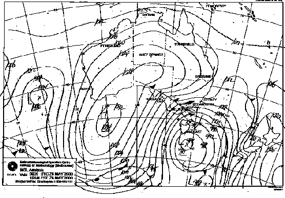
The satellite cloud animation at right shows hourly images from 10am EST Saturday to 8pm today. You will need to allow some time for the full animation to load. The spiralling cloud bands of the deep, slow-moving low that brought the first outbreak of colder air on Friday and Saturday can be seen under Tasmania. However, in the far southwestern corner, at 50°S, a wave can be seen developing on a frontal cloudband that had been moving NE from near the Antarctic coast for the previous 24 hours. Watch its progress and count the hours as it moves northeast and develops. Between 8pm Saturday and 2am today, an area of strong convection explodes in this airmass as it moves up, west of Tasmania. A conveyor belt of cold air (speckled cloud) follows in its rear. The convection maximum crosses the western Victorian coast around 2.30am, and maintains intensity until entering NSW around midday, weakening only slightly as it moves across the NSW Southern and Central Tablelands. The inverted comma shape of the cloudmass is characteristic of strong, deep southern cold pools. This one brought the most severe weather of the current polar outbreak during the 24 hours it moved over land, from low level snow this morning in southern Victoria to widespread snow on the NSW Northern Tablelands late this evening and into Monday. Below the cloud animation, Image 2 shows the situation in the upper atmosphere at 200hPa, or about 11.5km at 10am today. There is an enormous loop in the polar jetstream, with streamlines oriented to the NNE west of Tasmania right over the cold air conveyor belt. In fact, the polar jet circumnavigates Tasmania, with the area of light blue corresponding to winds between 60 and 70 knots (110 to 130km/h). Winds in this jetstream join the subtropical jet, where the strong temperature difference between tropical air in central Queensland and polar air over Tasmania produces an exceptionally strong jetstream maximum of over 260km/h over northern NSW (the deep red area). A deep low exists south of Tasmania, vertically aligned through the atmosphere with the low at the surface. |
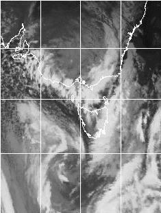 |
| Image 1 (above): Infrared satellite cloud animation hourly from 10.30am EST Saturday to 8.30pm today. NPMOC | |
 |
|
| Image 2 (above): 200hPa analysis at 10am today. Fiorino | |
| Image 3 shows the middle atmosphere pressure map at 500hPa, or about 5.5km. This, again, shows the vertically aligned low. The wind at this level flows along the isopleths, or lines of equal height (in geopotential metres) of the 500hPa pressure level, and can be seen to be almost due southerly from 50°S to the Victorian coastline. Wind arrows show the surface wind, with the buff-coloured area experiencing surface winds of between 30 and 50 knots (55 and 90km/h). |  |
| Image 3 (above): 500hPa heights and surface wind analysis at 10am today. Fiorino | |
| Image 4 also shows the same lines of equal height of the 500hPa level, but also shows the temperature at this level (green lines). From west of Tasmania northwards to Melbourne and the Otway coast, temperatures are between minus 32 and minus 34, around 15 degrees colder than they were a few days ago when more normal conditions prevailed. The north/south band of yellow/red curling into Victoria shows an area of vorticity maximum, or an area where the atmosphere is imparting maximum spin to the air, developing strong uplift and creating the area of spectacular convection. |  |
| Image 4 (above): 500hPa heights, temperature and vorticity analysis at 10am today. Fiorino | |
| Finally, Image 5 shows the 850hPa level, at about 1.3km, just far enough above the surface to be free of local topographical effects. The blue line labelled FR shows the boundary of freezing temperatures at this level pushing north from polar regions into central Queensland. The minus 3° isotherm extends from western Victoria to the NSW Central Tablelands. The light grey fill denotes areas with more than 95% humidity, while winds at this level can be seen to be predominantly 30 to 40 knots (55 to 75km/h), and strongly SSW'ly before arriving on the Victorian coast. |  |
| Image 5 (above): 850hPa analysis at 10am today. Fiorino |
Victoria
The polar surge first made landfall in western Victoria, ushered in by a heavy thunderstorm at Warrnambool around 3am, with 32mm in the gauge for the 24 hours to 9am. Over the next 6 hours, as the system moved northeast, snow fell generally as low as 200 metres above sea level, and settled on the ground at between 250 and 350m over a broad strip from the Western District east to Mt Donna Buang, and northeast to the Victorian Alps. Snow fell at Latrobe Valley Airport near Morwell at an altitude of 55m around midday, and there were frequent reports of small hail, sometimes confused with snow, to sea level and across Melbourne suburbs.
The most outstanding fall was in the Beechworth area, south of Wodonga in the state's northeast. Snow fell heavily on the Beechworth Plateau from soon after dawn, accumulating to 30cm in depth and completely isolating the town for several hours around the middle of the day. Downed trees and icy conditions made travel difficult to impossible in the area through into Monday. Snow fell to low levels around the Plateau, and was reported as settling at Baraduda, 7km SE of Wodonga at an elevation of 160m on Sunday afternoon, as well as in the neighbouring Yackandandah valley, and in Bright and Myrtleford. It is the second heaviest fall in the area in a hundred years, after the fall of July 1966.
Elsewhere in the state, Bureau observers reported falling snow at Casterton, Harrow, Dunkeld, Hamilton, Daylesford, Trentham and Ballarat in the west, Weeaproinah on the Otways southwest of Melbourne, Olinda and Seville in the Dandenongs and Noojee farther east, and at Marysville, Lake Eildon, Edi Upper and Strathbogie to the northeast.
Across the state, four deaths were caused by the weather, two by falling trees and two in motor accidents caused by the poor weather. Many roads were closed by snow or fallen trees, including the Maroondah Highway northeast from Melbourne, and the Harrietville to Mt Hotham section of the Alpine Road. Accidents caused by cars skidding into poles and ditches were common as drivers confronted a new motoring experience. A hundred vehicles and their sightseeing passengers were trapped on Mount William, south of Halls Gap in the Grampians, when a sudden snowstorm closed the access road around 3.30pm. Police and rangers took 4 hours to gingerly guide them to below the snowline. Thirteen students had to be rescued from a hut at Langford's Gap near Mitta Mitta in the northeast.
Alpine ski resorts were jubilant, however, with over a metre of powder snow recorded at Mt Hotham and over 80cm at Falls Creek. Farmers in the state's parched southwest were also pleased with around 70mm of precipitation, even if some stock were lost in the cold.
New South Wales
After scattered overnight and morning falls, snow began in earnest along the NSW Southern and Central Tablelands and higher parts of the nearby Slopes and coastal ranges during the afternoon as the cold pool moved northeast. The mechanism that produced abundant snowfall over Beechworth also dumped around 20cm in the Batlow/Tumbarumba area, closing the Batlow to Adelong and Tumut roads for the day, and the Batlow to Tumbarumba road into Monday. Snow fell in the area as low as Gundagai, 250m above sea level.
Exceptionally cold daytime temperatures accompanied the snow, with Canberra recording its lowest May maximum on record, 4.3° comprehensively dismissing the previous record of 6.0 set in 1949. It was also the capital's coldest day since 28 June 1966, and the earliest snowfall in 23 years. The temperature sank as low as 1.3 at 2.30pm. Snow fell for more than an hour to a depth of 4 to 8cm in some suburbs and 10cm on the higher hills. It caused a sensation at the Canberra Raiders vs Wests Tigers rugby league match at Bruce Stadium when most of the match was played in falling snow with commentators barely able to see across the field. Canberrans enjoyed the rare thrill of skiing on Mt Stomlo just west of the City. Aircraft delays occurred as Canberra Airport closed intermittently due to poor visibility.
Farther north, persistent light snow overnight in the triangle bounded by Orange, Lithgow and Crookwell intensified with the passage of the cold pool, rapidly making roads in the area above about 800m impassable as snow accumulation reached 7 to 10cm. Strong winds caused deeper drifts. At one stage, both Bathurst and Orange were isolated with all roads out of the cities snowbound. A mass police and State Emergency Services rescue of passengers from over 300 vehicles was required on the Great Western Highway between Lithgow and Bathurst. A rapid deterioration in the weather late in the afternoon made the highway impassable along a 10km section from Yetholme to Mount Lambie. All accommodation in Bathurst was booked out with stranded travellers, and over 200 had to bed down in emergency accommodation at the Bathurst Roswell Sheep and Cattle Drome. Graders were brought in to help clear the snow, but over 100 cars were still stranded at 11pm. Downed trees caused widespread power blackouts in Orange and to the south and southeast, while schools in Orange were closed on Monday as continuing cold weather kept many roads snowbound.
Five to 10cm of snow fell on the Blue Mountains between 3 and 7pm, closing the Great Western Highway between Wentworth Falls and Lithgow until Monday morning, and Bells Line of Road until Tuesday. With the Mudgee Road also closed at Cherry Tree Hill, Lithgow too became isolated and accommodation filled with stranded travellers. Twenty travellers just east of Lithgow weren't so lucky, and took refuge for the night in a bushfire shed at Clarence. Snow fell on the Sydney side of the Blue Mountains as low as Springwood, and settled at North Springwood. A number of motorists were trapped on the Great Western Highway between Katoomba and Mt Victoria, as well as a busload of passengers returning to Alice Springs after the Corroboree 2000 event in Sydney. They were rescued and transported to local motels by a fleet of 25 police and SES 4WD vehicles. Bowral, behind the Illawarra escarpment, had an hour's snow from 4.30pm, and gusty westerly winds spilling over the escarpment brought down trees and damaged roofs in the Wollongong area. In parts of Sydney, small hail fell as the change went through earlier in the afternoon.
Pre-season falls in the NSW ski resorts were nearly as good as Victoria's, with 60 to 80cm of powder snow reported at higher levels, and 30cm falling in Thredbo Village.
Tasmania, South Australia and Queensland
Although bypassed by the second surge of polar air, Tasmania still felt the effects of the cold outbreak with the Lyell Highway cut by snow between Derwent Bridge and Queenstown, and the Murchison Highway impassable between Queenstown and Waratah Junction. Good snowfalls were reported from the Ben Lomond ski resort. Smithton on the northwest coast reported sleet at the 6am and noon observations, while snow fell across the Central Plateau down to 600m and blanketed Mount Wellington behind Hobart with a full cover.
In South Australia, galeforce winds continued to blow until the afternoon. Two men were killed when a house they were building collapsed in the high winds.
The first wave of colder air that passed through South Australia on Friday pushed north into Queensland and the Northern Territory late yesterday. In the dry atmosphere after its long passage over land, temperatures plummeted overnight to 8 to 10° below average, with a minimum of 1° at Charleville Airport and 3.0 as far north as Longreach.
Australian May lowest maximum temperature record broken
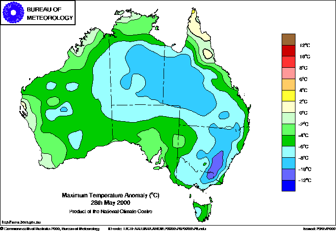 |
| Maximum temperature departure from normal for today. BoM |
The Australian record for the lowest May maximum temperature was broken today -- and by three weather recording stations! Thredbo's Crackenback automatic weather station, NSW, recorded a top temperature for the 24 hours to 9am Monday of only -6.0°, while Mt Hotham and Falls Creek in Victoria recorded -5.7 and -5.2 respectively. The previous record was set when Perisher Valley recorded -5.5 on 31 May 1977. It should be noted, however, that many Alpine weather stations have only been operating for the past 10 to 20 years, with only a handful reporting temperatures during earlier major cold outbreaks, such as those of 1977 and 1986. Crackenback, Mt Hotham and Falls Creek were not operational in 1977, when it is likely that colder temperatures were recorded.
The extraordinary extent of this cold outbreak is graphically shown in the maximum temperature anomaly map for today (left). The entire continent, with the exception of northern Cape York Peninsula and tiny areas near Cairns in Queensland and Carnarvon in WA, recorded below average maximum temperatures, with vast areas of NT, Qld and NSW recording top temperatures 8° or more below average. Tumbarumba in southern NSW experienced the coldest day today, relative to normal, with a top of only 1.7, 13.4 below average. Undoubtedly a number of temperature records will be broken, and these will appear in the Records box for the appropriate day as they become available.