New South Wales
The day dawned to reports of heavy snow on parts of the NSW Northern Tablelands, with the main New England and Oxley highways closed by snow and black ice in the Walcha/ Bendemeer/ Armidale area. The connecting road between Walcha and Uralla was reported to be closed by 30cm of snow. Snow also fell on the Dorrigo Plateau and westwards to Armidale, and farther north from Guyra to Glen Innes. The Barrington Tops behind Gloucester also recorded snow. Top temperatures across northern and northwestern NSW were between 8 and 11° below average, with Coonabarabran's top of 8.1 some 11.2 below. Dubbo experienced its coldest May day on record when the mercury only reached 8.9°. Earlier, Byron Bay and Wollongong recorded record low minimum temperatures.
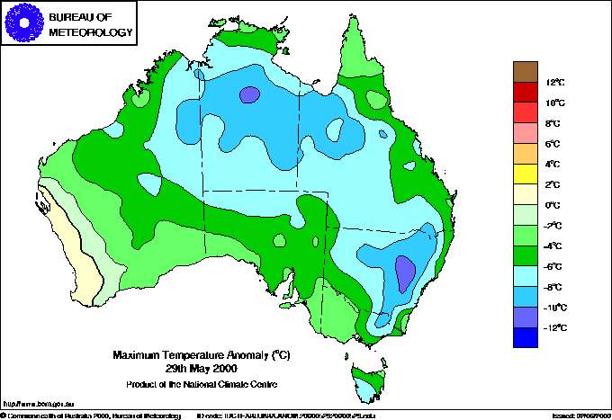 |
| Maximum temperatures today continued to be well below average across much of the continent. |
In the Snowy Mountains, snow ploughs worked overnight to keep roads open, though the Perisher Valley to Charlotte Pass road and the Cabramurra to Khancoban road are closed, probably for the season. Charlotte Pass reported a snow depth of 110cm at 9am, and Thredbo had 35cm in the Village. Light snow continued overnight in the Tumbarumba area to the west. Farther east, on the Monaro Plains, snow was widespread overnight closing roads this morning including the Snowy Mountains Highway at Brown Mountain between Bega and Nimmitabel, where four semi-trailers became stranded in snow and ice near the top of the mountain. Chains were required on the Highway between Cooma and Talbingo.
Light snow and sub-zero temperatures continued in the state's Central West, with the Mitchell Highway between Bathurst and Orange, Bells Line of Road east of Lithgow and the Goulburn to Crookwell road closed, along with many secondary roads in the area. Drifts to 1 metre in depth were reported by the Oberon Bureau observer.
Victoria
Travel problems continued in many parts of the state today with icy roads and fallen or dangerous trees and branches the main difficulty. Roads in the Beechworth area remained closed or hazardous, with schools in the area closed. In the high country around Ballarat, Bendigo and Gisborne, snow and ice led to minor accidents. The Falls Creek Bureau observer reported a snow depth of 100cm at 9am. Gales continued in Bass Strait and around the coast and in the high country, beginning to ease by early evening. The arrival of the third pulse of colder air from the south late in the afternoon briefly strengthened winds, with Port Fairy recording a top gust of 94km/h just before 7pm. Some heavy hail showers were reported in Melbourne late evening, with hail 2 to 3cm deep at Murrumbeena in the city's southeast and 1 to 2cm deep at the Yallambie Rd/Lower Plenty Rd intersection. Lightning struck signal controls at Heidelberg causing lengthy delays. Some flash flooding was also reported in the area with unofficial falls up to 55mm.
Tasmania
Light snow continued above about 800m in central, western and northeastern parts of the state, with hail showers to sea level through the day. Winds freshened during the afternoon as the third pulse of colder air brushed the state's west coast, with Cape Grim in the northwest reporting a gust of 113km/h at 4pm. With most of the action taking place to the west of Tasmania, the state has been spared heavy snowfalls, and temperatures have remained relatively mild at only 3 to 6° below normal.
Low temperatures in the north
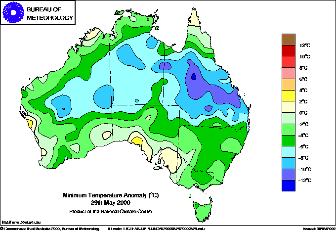 |
| Minimum temperatures across central and southern Queensland this morning were 8 to 12 below average, causing a raft of May records to fall. |