 |
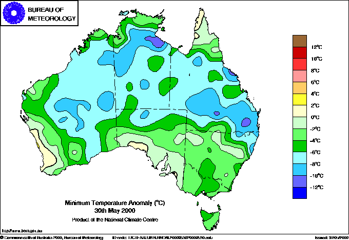
| Almost the entire continent experienced below average minimum (above) and maximum (below) temperatures today. Click the thumbnail for full image. |
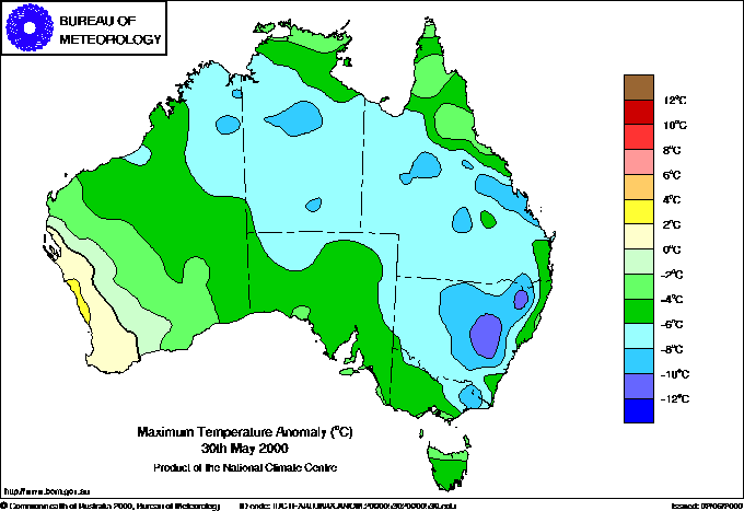 |
Temperatures continued well below average over almost the entire Australian continent today, as this extraordinarily widespread and intense cold outbreak for May began to ease in the hardest-hit states of NSW and Victoria.
The only areas of above average minima were the WA coast for several hundred kilometres north and south of Perth, and tiny areas on the Great Australian Bight and Cape York Peninsula. Overnight temperatures were 6 to 12 below normal across most of northern and central Australia. Records again fell in NT, Queensland and NSW, with Centre Island NT and Cape Byron NSW breaking their May minimum temperature records for the second successive day. Brisbane Airport recorded 4.3 both yesterday morning and this morning, both beating the previous record of 4.7 in 51 years of record.
Only the WA southwest and central coasts recorded above average maxima, with the impact of successive waves of cold southern air spreading as far as the Timor Sea. Daytime temperatures were 6 to 10° below average across half the continent, and up to 12 below in NSW where Wellington's town weather station recorded a top of 7.3, 12.4 below. Dubbo broke its lowest maximum temperature record for May for the second day in a row. (See box below for details of records).
The past few days have seen a number of low maximum temperature records fall, but there are several other measures of the intensity and longevity of this remarkable May cold spell unearthed by Bureau climatologist Blair Trewin. Wagga Airport has recorded four consecutive days of sub-10° maxima to and including today -- the longest period of sub-10° maxima in May in the airport's climatic history which goes back to 1941 is 2 days. Bathurst has recorded three consecutive days with maxima below 6° to today, which has happened on only 6 occasions in the past 92 years, and never in May. Orange Airport has had 3 consecutive days to today where the maximum failed to reach 4, and Dubbo 3 days below 11, both the first times this has happened in May.
In a check of records going back to 1967, Blair found that today and Wednesday 31 May were the only two May days when a maximum temperature of 30° or more was not recorded somewhere in Australia. In fact, it failed to reach 30° anywhere in Australia on the 6 days from today, 30 May, to Sunday 4 June, an unprecedented run in any season.
Sydney's top of 13.1 today, with part cloud and a strong westerly wind, was the second lowest in May for 61 years, behind only 12.9 on 7 May 1984, a very wet day. It was also the coldest day for any month for 4 years. The last 3 days' maxima in Sydney of 14.2, 14.3 and 13.1 represent the first time ever there have been 3 consecutive May days under 14.5. Oberon on the Central Tablelands recorded its second sub-zero maximum in a row today, with a top of -0.8 following yesterday's -0.6, only the fourth and fifth sub-zero maxima for any month in 35 years' record, and the only two consecutively (the station relocated to a site some 100m higher 11 years ago).
Victoria
The third pulse of cold southern air in the present polar outbreak crossed Victoria late yesterday, leaving the state in a cold, unstable southerly airstream. This produced strong winds, hail and some heavy rain showers overnight and this morning in the Melbourne area, covering roads with leaf litter, small branches and water, and generally impeding the morning peak. South Channel Island, in southern Port Phillip Bay, recorded a peak wind gust of 115km/h a little after midnight. Unconfirmed reports of snow were received from eastern suburbs as close to Melbourne CBD as Bulleen. Viewbank AWS near Heidelberg in the city's east recorded 47mm for the 24 hours to 9am, as did Longwarry in the western Latrobe Valley, while Arrabri, east of Warburton, recorded 48.0, though there were unofficial reports as high as 70mm in the city's east. The Dudley Street bridge in West Melbourne was flooded, and the Maroondah Highway east of the city remained closed by storm damage.
A fourth pulse of cold air crossed East Gippsland late afternoon, bringing falls of around 10mm in a few hours falling as snow above about 800m. Elsewhere in the state, temperatures began to warm during the day with rain and snowfalls generally clearing.
New South Wales
Light snow continued to fall intermittently the full length of the Great Divide in NSW today. At Oberon, the observer reported 30cm snow depth at 9am, with drifts to 1 metre, and roads south of Oberon remained closed. Black ice posed threats on many roads on the tablelands. The continuing low temperatures led to record power consumption last night and Monday night, with peak evening demands of 11,800 megawatts exceeding last winter's record by 400mW.
The fourth and final pulse of cold air which crossed Victoria's East Gippsland coast mid afternoon gave further heavy snow in the Bombala area late in the afternoon. The Bombala -- Nimmitabel Road was closed, as was the Snowy Mountains Highway again at Brown Mountain. Although there were reports of renewed snowfalls settling in the Mt Lambie area between Lithgow and Bathurst late tonight, the weather appeared to be clearing late evening as the fourth cold air pulse moved away from the coast.