Unseasonal rainfall on Queensland northern tropical coast
Cold night in the Snowies
Heavy rain continues in coastal southwestern WA, but none where it's needed
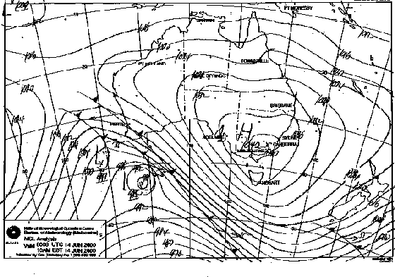
| A rare sight on an Australian weather map -- a high pressure system with a closed 1040hPa isobar -- has resulted from the major blocking pattern of the past few weeks. The Bureau of Meteorology chart for 10am EST this morning (above) shows the high, with a central pressure of 1042 over the Snowy Mountains. The 200hPa pressure level chart (right) graphically illustrates the blocking situation with a remarkable jetstream pattern. A particularly strong jetstream, with core winds over 150 knots (280km/h), is completely split by the block over Victoria, and has commenced looping under the block towards New Zealand. Fiorino | 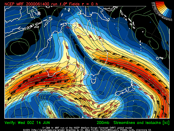 |
The high pressure system that has been slowly building over southeastern Australia for the past week peaked with a central pressure of 1042hPa late this morning. The High has developed due to a major blocking pattern in the normal west to east movement of systems that has been evident since late May. The highest barometer readings reported at 9am EST were 1042.4hPa at Khancoban, just west of the Snowy Mountains, 1042.3 at Omeo in eastern Victoria, and 1041.7 at Canberra Airport. The 9am barometer readings at Sydney and Brisbane came within a whisker of breaking their all-time records. At Sydney City, the pressure between 9 and 10am was 1039.3, compared to a record variously reported at 1039.7 on 12 June 1930 and 1040.0 on 7 or 8 July 1987. At Brisbane Airport, the pressure reached 1033.9hPa at 9am, just shy of a record 1034.1, also set on 7 or 8 July 1987. While the Canberra and Omeo readings should be treated with some caution, as the conversion of pressure readings from higher altitudes to sea level can be unreliable, the reading at Khancoban, 340m above sea level, can be regarded as an accurate maximum pressure for this unusual event.
Meanwhile, unseasonable rainfall continues to plague northern Queensland as a result of strong moist southeasterly winds set up by the High. Innisfail has recorded 82.2mm over the past two days, and Babinda 83.8mm, delaying the start of the sugar cane crushing season in the area.
Also a by-product of the High was a particularly cold night at Kosciuszko Chalet near Charlotte Pass in the NSW Snowy Mountains. The minimum this morning was -15.6, the coldest since July 1998. Nearby Perisher Valley recorded only a balmy -9.7. Elsewhere across NSW and in Victoria and South Australia, sub-zero minima were common. Cooma Airport recorded -9.9, while in SA, Yunta, 270km NNE of Adelaide in the Northern Mt Lofty Ranges, recorded -5.
The slow-moving rainband that brought heavy falls to the Bunbury area yesterday dumped 50 to 75mm along the WA's southwestern coast from Mandurah to Jurien this morning. Pinjarra South, about 80km south of Perth, recorded the highest fall for the 24 hours to 9am with 124mm in the gauge. Although this is the wet season in southern WA, 24 hour falls in excess of 100mm are rare. Mandurah recorded 89mm between midnight and 9am and Jandakot airport, just south of Perth, recorded 81mm between 3am and midday. Other heavy 24 hour and short duration falls are given below. The rain did not penetrate far inland, with Northam, 80km east of Perth, recording 23mm between 9am and 3pm, but places farther east recording little if any rain. The unusually dry start to winter has set grain sowing programs back, with Agriculture Western Australia saying that the growing season is running more than 2 weeks late. as
new and corrected information becomes available, with updates underlined
as
new and corrected information becomes available, with updates underlined