Australian Weather News


AWN Home Page
Full news index

Monday, 02 SEP 2002

About Australian Weather News

Storm-force winds sweep southeastern states 3/12/02
An unusual sight on an Australian weather map, a high of 1020 not too far from Southern Ocean lows of 949 and 960hPa. This is the surface chart for 4pm EST today. BoM

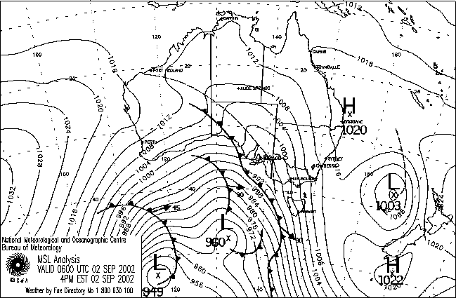
Winds gusted to storm force (90km/h and above) this evening across SA, western NSW, much of Victoria and exposed parts of Tasmania, bringing chaos to Melbourne and causing damage and danger elsewhere. Strong pressure gradients developed between an exceptionally deep low pressure complex moving eastwards well to the southwest of Tasmania and a high pressure ridge over SE Qld. By 10pm EST the main low, some 2,100km SW of Tasmania, was analysed with the impressively low central pressure of 945hPa, while the lowest pressure recorded over southern Victoria was 991.5 at 9pm at Avalon Airport near Geelong, the lowest in about 4 years. With a pressure of 1018.0 at Coffs Harbour at the same time, the gradient across the southeast was guaranteed to produce an eventful night.

Emergency crews were kept busy in Melbourne during the day with trees brought down on houses, and a house roof blown off and a scaffolding collapsing onto a factory in North Melbourne. Five aircraft were damaged at Essendon Airport, and a nursing home at Warragul in the Latrobe Valley lost its roof. The wind dropped a little late afternoon, but increased to even higher levels during the evening as the trough shown entering western Victoria on the chart above crossed the city (see report for 3 September). High wind gusts during the evening included 106km/h at Melbourne Airport, 111 at Dunns Hill near Mt Dandenong, and a hurricane-force 122km/h at Fawkner Beacon which is located in Port Phillip Bay 6km west of Sandringham and 10km SW of St Kilda. Most Melbourne area anemometers recorded peak gusts between 85 and 95km/h (see the extremes below for details.) Farther afield, Eildon Fire Tower recorded a top gust of 119km/h, and the summits of Mt Hotham and Mt Buller recorded 115km/h.

The east of South Australia, western NSW and northwestern Victoria were shrouded in blowing dust and sandstorms as winds averaged 40km/h but gusted to storm force. Strong inland gusts included 85km/h at Woomera and Oodnadatta, 95 at Marree and Yunta, all in SA, and 89 at Broken Hill in NSW. At Broken Hill, power lines were brought down in the City overnight into Tuesday.

National weather extremes for today
Data provided by the Bureau of Meteorology
Last updated at 19:23 EST on 06/09/02

Quality control note: Data is complete, and has been visually checked by AWN for gross errors. Less obvious errors may remain. See Explanation of Extremes Pages for more information
Records set this day (none known)

Todays highest rainfall totals for the 24 hours to 9am. It includes the top 5 totals received, and/or all reported falls of 50mm or more.

37.0 LORD HOWE ISLAND AERO Islands
21.2 ALBANY SW & S Coast WA
21.0 GINGIN AERO Lower West WA
20.8 WATSONIA Central West WA
20.2 TABLETOP Central West WA

WESTERN AUSTRALIA
    Central West
20.8 WATSONIA
20.2 TABLETOP
    Lower West
21.0 GINGIN AERO
    SW & S Coast
21.2 ALBANY

ISLANDS
    Islands
37.0 LORD HOWE ISLAND AERO

High rainfall for periods of 6 hours or less.


SOUTH AUSTRALIA
    Kangaroo Is
CAPE BORDA
18.0mm in 3 hr to 17:30 6.0mm/h

Todays highest & lowest temperatures

Maximum Minimum
38.3 BIRDSVILLE POLICE STATION Channel Country QLD
37.0 MOOMBA AIRPORT NE Pastoral SA
37.0 LONGREACH AERO Central West QLD
36.9 BALLERA GAS FIELD Far SW QLD
36.8 WINDORAH POST OFFICE Channel Country QLD
26.0 NORTHERN ENDEAVOUR Islands
24.0 MCCLUER ISLAND Darwin-Daly NT
23.6 TROUGHTON ISLAND N Kimberley WA
23.0 COCONUT ISLAND N Peninsula QLD
23.0 HOLMES REEF Islands
5.4 MT HOTHAM Upper NE VIC
6.0 THREDBO (CRACKENBACK STATION) AWS Snowy Mtns NSW
6.5 MOUNT WELLINGTON Southeast TAS
6.7 MOUNT READ W Coast TAS
7.0 MOUNT BULLER Upper NE VIC
-6.0 CHARLOTTE PASS (KOSCIUSKO CHALET) Snowy Mtns NSW
-5.1 BOMBALA AWS Goulburn/Monaro NSW
-5.0 PERISHER VALLEY SKI CENTRE Snowy Mtns NSW
-4.5 GLEN INNES AG RESEARCH STN N Tablelands W NSW

Todays greatest temperature variations from normal

Maximum Minimum
+11.5   33.8 WOOMERA AERODROME NW Pastoral SA
+10.7   31.0 LOXTON RESEARCH CENTRE Upper Murray SA
+10.7   35.1 TIBOOBURRA POST OFFICE Far Northwest NSW
+10.6   34.9 ANDAMOOKA NW Pastoral SA
+10.6   33.7 LEIGH CREEK AIRPORT NE Pastoral SA
+10.6   31.8 WHYALLA AERO W Agricultural SA
+10.6   28.4 YONGALA Upper North SA
+10.6   33.4 MENINDEE POST OFFICE Lower Darling NSW
+12.1   22.3 ALICE SPRINGS AIRPORT Alice Springs NT
+9.2   20.1 KULGERA Alice Springs NT
+8.6   19.4 MARLA POLICE STATION NW Pastoral SA
+7.4   20.2 GILES METEOROLOGICAL OFFICE Interior WA
+7.3   16.8 LEIGH CREEK AIRPORT NE Pastoral SA
-8.0   19.8 THREE RIVERS E Gascoyne WA
-7.2   23.8 WITTENOOM W Pilbara WA
-6.8   18.7 MEEKATHARRA AIRPORT Murchison WA
-6.7   19.5 WILUNA Interior WA
-6.5   19.1 YEELIRRIE Goldfields WA
-8.6   -4.5 GLEN INNES AG RESEARCH STN N Tablelands W NSW
-7.9   0.0 DALWALLINU COMPARISON Central West WA
-7.2   8.9 GEORGETOWN POST OFFICE Upper Carpentaria QLD
-7.2   -2.0 WANGARATTA AERO Lower NE VIC
-6.6   -1.0 EAST SALE AIRPORT W Gippsland VIC

Highest wind gusts above 89km/h or mean wind above 62km/h (gale force). Wind direction and mean windspeed shown in brackets.

NORTH ISLAND Central West WA : 76 (230/ 67 ) at 00:47
CAPE LEEUWIN SW & S Coast WA : 93 (260/ 80 ) at 04:14
CAPE NATURALISTE SW & S Coast WA : 83 (250/ 69 ) at 01:54
WOOMERA AERODROME NW Pastoral SA : 85 (300/ 63 ) at 14:30
OODNADATTA AIRPORT NE Pastoral SA : 85 (310/ 63 ) at 19:45
MOOMBA AIRPORT NE Pastoral SA : 85 (310/ 65 ) at 23:33
MARREE AERO NE Pastoral SA : 95 (330/ 70 ) at 19:05
WHYALLA AERO W Agricultural SA : 91 (260/ 69 ) at 17:43
NORTH SHIELDS (PORT LINCOLN AERO) W Agricultural SA : 82 (310/ 63 ) at 22:48
PORT AUGUSTA AERO W Agricultural SA : 74 (240/ 65 ) at 17:53
YUNTA AIRSTRIP Northeast SA : 95 (320/ 70 ) at 17:45
CAPE WILLOUGHBY Kangaroo Is SA : 93 (350/ 72 ) at 02:44
MOUNT LOFTY Mt Lofty Ranges SA : 93 (340/ 58 ) at 07:00
WILCANNIA AERODROME AWS Far Northwest NSW: 83 (330/ 65 ) at 21:25
BROKEN HILL AIRPORT AWS Lower Darling NSW: 89 (300/ 69 ) at 22:05
THREDBO (CRACKENBACK STATION) AWS Snowy Mtns NSW: 83 (320/ 69 ) at 13:00
MOUNT BULLER Upper NE VIC: 115 (360/ 78 ) at 22:00
MT HOTHAM Upper NE VIC: 115 (360/ 93 ) at 22:00
MT MOORNAPA W Gippsland VIC: 93 (330/ 43 ) at 22:45
VIEWBANK (ARPANSA) E Central VIC: 95 ( 10/ 54 ) at 23:09
MOORABBIN AIRPORT E Central VIC: 82 (360/ 67 ) at 23:26
MELBOURNE AIRPORT E Central VIC: 106 ( 10/ 70 ) at 21:08
FRANKSTON AWS E Central VIC: 83 (350/ 63 ) at 23:30
DUNNS HILL E Central VIC: 111 ( 10/ 70 ) at 23:13
RHYLL E Central VIC: 89 (360/ 63 ) at 21:51
FAWKNER BEACON E Central VIC: 122 (360/ 85 ) at 23:21
POINT WILSON W Central VIC: 83 ( 10/ 65 ) at 18:48
MANGALORE AIRPORT N Central VIC: 95 ( 20/ 63 ) at 21:12
KILMORE GAP N Central VIC: 95 ( 10/ 70 ) at 21:30
EILDON FIRE TOWER N Central VIC: 119 ( 10/ 74 ) at 21:39
CAPE OTWAY LIGHTHOUSE W Coast VIC: 91 (360/ 54 ) at 09:30
COLAC (MT GELLIBRAND) W Coast VIC: 98 ( 10/ 76 ) at 17:45
MOUNT WELLINGTON Southeast TAS: 117 (340/ 93 ) at 22:30
TASMAN ISLAND Southeast TAS: 100 ( 10/ 82 ) at 21:00

Other extremes

..