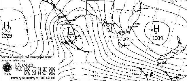
Australian Weather News |
Sunday, 15 SEP 2002 |
Gales
batter entire southern coastline Victorians and South Australians battle bushfires, duststorms as temperature records fall |
||
In an unusually widespread meteorological event today, strong to gale force winds scoured the entire southern coastline of the continent, from its most southwesterly point at Cape Leeuwin to its most southeasterly on Tasman Island. A deepening low of 980hPa in the Great Australian Bight and strengthening highs of over 1030hPa both to the west of Perth and east of Sydney made for beautiful symmetry as well as strong pressure gradients along 4,000km of coastline. Take a look at the list of high wind speeds and wind gusts in today's National Weather Extremes below to see the extent and uniformity of this event. The strongest winds today were in southern SA and western Victoria. The full report is given in the news for 16 September. More than 50 fires broke out across country Victoria today, with a further 120 in the Melbourne metropolitan area. Northerly winds gusting to 80 to 100km/h accompanied low humidity and record September temperatures to fuel the grass, scrub and forest fires. The largest, a 225ha blaze in a pine plantation at Mt Lanarch near Beaufort, 45km WNW of Ballarat, was still out of control late this evening, though all other fires had been contained. Almost 20 of the fires were in the Bendigo area. In South Australia, the Country Fire Authority responded to 300 calls, the worst an 80ha fire in Wirrabarra Forest near Port Germein, and a 30ha forest and scrub fire at Delamere on the Fleurieu Peninsula. In a parched band of country from the Victorian Mallee and Wimmera across to South Australia's Eyre Peninsula, duststorms were frequent. Severe duststorms were reported from Mildura, with visibility on the Sturt Highway to Renmark reduced to a few metres. In Melbourne, the temperature reached 28.5° late afternoon, the highest maximum ever recorded so early in the year. Cranbourne Botanic Gardens, 45km SE of Melbourne, and Weeaproinah in the Otway Ranges to the city's southwest both set new September records, as did Wynyard Airport on Tasmania's north coast. |
National
weather extremes for today |
|
Quality control note: Data is complete, and has been visually checked by AWN for gross errors. Less obvious errors may remain. See Explanation of Extremes Pages for more information | |
Records
set this day (previous record and years of computerised record shown in
brackets): Highest daily rainfall for September: Pemberton WA: 48.4 (45.2, 60) Windy Harbour WA: 36.8 (34.0, 17) Highest daily maximum temperature for September: Cranbourne Botanic Gardens Vic: 27.0 (26.5, 12) Weeaproinah Vic: 23.0 (21.2, 17) Wynyard AP Tas: 21.0 (19.9, 15) |
|
Todays highest rainfall totals for the 24 hours to 9am. It includes the top 5 totals received, and/or all reported falls of 50mm or more.
131.0 LAKE BENNETT RESORT Darwin-Daly NT |
High rainfall for periods of 6 hours or less.
|
Todays highest & lowest temperatures |
|
Maximum | Minimum |
38.0 WYNDHAM AERO N Kimberley WA 37.5 KIMBERLEY RES.STATION E Kimberley WA 37.0 WYNDHAM POST OFFICE N Kimberley WA 37.0 KUNUNURRA AERO E Kimberley WA 37.0 RABBIT FLAT Alice Springs NT 37.0 MARLA POLICE STATION NW Pastoral SA 37.0 TARCOOLA AERO NW Pastoral SA |
27.4 NORTH SHIELDS (PORT LINCOLN AERO) W Agricultural SA 27.0 NORTHERN ENDEAVOUR Islands 26.0 WYNDHAM POST OFFICE N Kimberley WA 25.0 TROUGHTON ISLAND N Kimberley WA 25.0 MCCLUER ISLAND Darwin-Daly NT 25.0 WARRUWI Arnhem NT 25.0 CAPE FOURCROY Islands |
7.0 THREDBO (CRACKENBACK STATION) AWS Snowy Mtns NSW 7.8 MT HOTHAM Upper NE VIC 9.0 CHARLOTTE PASS (KOSCIUSKO CHALET) Snowy Mtns NSW 9.7 MOUNT BARKER SW & S Coast WA 10.5 PERISHER VALLEY SKI CENTRE Snowy Mtns NSW |
-4.0 GOULBURN AIRPORT AWS Goulburn/Monaro NSW -3.8 COOMA VISITORS CENTRE Goulburn/Monaro NSW -2.4 BRAIDWOOD RACECOURSE AWS South Coast NSW -1.9 CANBERRA AIRPORT Goulburn/Monaro NSW -1.8 TUGGERANONG (ISABELLA PLAINS) Goulburn/Monaro NSW |
Todays greatest temperature variations from normal |
Maximum | Minimum |
+13.2
32.1 ELLISTON W Agricultural SA +12.8 33.0 POLDA (GUM VIEW) W Agricultural SA +12.4 23.9 STRATHGORDON VILLAGE W Coast TAS +12.3 34.0 KYANCUTTA W Agricultural SA +12.2 29.0 LAVERTON RAAF W Central VIC |
+14.1
24.3 ALICE SPRINGS AIRPORT Alice Springs NT +13.8 21.8 ARKAROOLA NE Pastoral SA +13.8 21.7 WHYALLA AERO W Agricultural SA +12.3 19.2 KIMBA W Agricultural SA +12.2 23.0 MARLA POLICE STATION NW Pastoral SA |
-8.4
12.0 SALMON GUMS RES.STN. Goldfields WA -7.8 20.0 THREE RIVERS E Gascoyne WA -7.1 9.7 MOUNT BARKER SW & S Coast WA -7.0 18.5 MEEKATHARRA AIRPORT Murchison WA -7.0 16.0 MORAWA POST OFFICE Central West WA -7.0 19.2 WILUNA Interior WA |
-5.2
-0.6 GOULBURN PROGRESS ST Goulburn/Monaro NSW -5.0 -1.4 NERRIGA COMPOSITE South Coast NSW -5.0 -1.9 CANBERRA AIRPORT Goulburn/Monaro NSW -5.0 -3.8 COOMA VISITORS CENTRE Goulburn/Monaro NSW -4.8 -0.8 YASS (LINTON HOSTEL) Goulburn/Monaro NSW |
Highest wind gusts above 89km/h or mean wind above 62km/h (gale force). Wind direction and mean windspeed shown in brackets.
ROTTNEST ISLAND Lower West WA : 80 (200/ 63 ) at 05:37 |
Other extremes .. |