Australian Weather News


Go to the main news page Find a place on a map

Wednesday 31 May 2000

Cold weather continues over much of Australia
Wet and windy in WA
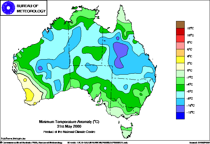
Well below normal minimum (above) and maximum (below) temperatures continued over most of the continent today.
It was another exceptionally cold day over all but the far southwest of Australia today, with the focus of low temperatures moving to Queensland and the NSW North Coast. Cape Byron Lighthouse had the dubious distinction of breaking its May minimum temperature record for the third consecutive day: the previous lowest minimum in a relatively short 23-year computerised record was 8.8, and this has been successively broken by a reading of 6.5 on Monday, 5.5 on Tuesday and 4.3 today. The intensity of this cold spell can be gauged by the fact that Smoky Cape Lighthouse broke its all time minimum record of 4.2 in 44 years of record this morning when the thermometer dropped to 2.5. The previous record low May minimum at the lighthouse had been 5.9. Further records were set in Queensland, with details below. In western Queensland, Charleville Airport began the day with a minimum of -3.0, 12 below average, and much of Queensland, including the central and southern coasts, recorded minima 8° or more below normal.

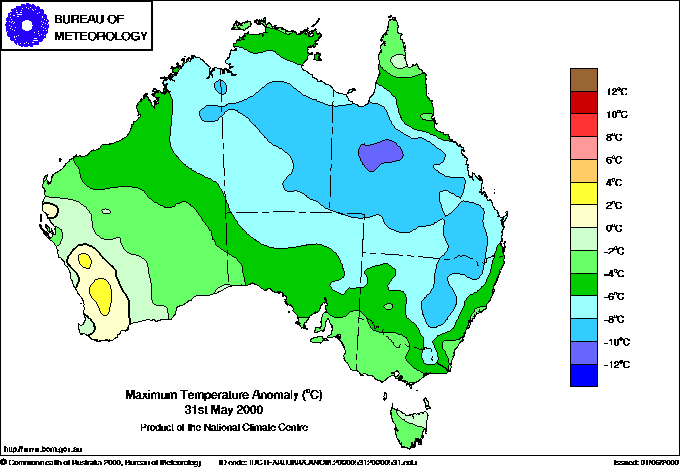
Maximum temperatures were again 6° or more below normal over more than half the continent, with the coldest area in western Queensland where top temperatures struggled to reach 10° below average in the cold airmass despite clear skies. The highest temperature in the nation was only 28.6 at Pirlangimpi (Garden Point) on Melville Island north of Darwin.

Light overnight snow was again reported from the NSW Northern Tablelands around Guyra and the Central Tablelands at Orange, Bathurst and Oberon, but cleared during the morning.

In Western Australia, isolated very heavy rain accompanied the passage of a cold front and pre-frontal trough over the state's central and southwest coasts. Denham on Shark Bay, 700km north of Perth, recorded 50mm in 3 hours between midnight and 3am, while Witchcliffe AWS, 10km south of Margaret River, recorded 41mm between 3am and 9am.

Today's highest rainfall totals for the 24 hours to 9am

53.2 Denham WA
51.0 Mt Read Tas
45.0 Wexham WA
33.8 Margaret River WA

Today's highest & lowest temps

Other extremes

Rainfall:
Denham WA: 50mm in 3h to 3am
Witchcliffe WA: 43mm in 6h to 9am
Mt Read Tas: 41mm in 12h to 9am

Wind gusts:
Rottnest Is WA: 83km/h at 2.30am

Records set this day

Lowest minimum temperature for May (previous record and years of computerised record shown in brackets):
Giles WA: 2.0 (equalling record breaking minimum two days ago)
Windorah PO Qld: 1.2 (1.9, 34)
Lady Elliot Is Qld: 12.0 (12.5, 44)
Sandy Cape Qld: 9.6 (10.0 40)
Quilpie AP Qld: 1.4 (1.6 44)
Cape Byron NSW: 4.3 (5.5 yesterday!, 22)
Smoky Cape NSW: 2.5 (5.9, 44)

Maximum Minimum
28.6 Pirlangimpi NT
(See news item for 30 May 2000)
25.0 Coconut Is Qld
-2.0 Crackenback NSW -8.0 Crackenback NSW

Greatest variations from normal

Maximum Minimum
+3.1
24.0 Northam WA
+6.3
12.6 Wandering WA
-10.6
9.2 Peak Hill NSW
-10.4
14.5 Tambo Qld
-10.3
19.4 Julia Creek Qld
-12.0
-3.0 Charleville AP Qld
-10.8
6.4 Double Is Pt Qld

  • Times stated are the clock time in force in the relevant state or territory

  • Stories, including those in the archives, are as new and corrected information becomes available, with updates underlined

  • Australian Weather News gratefully acknowledges the Bureau of Meteorology as the collector and main source of meteorological data in Australia, along with the thousands of observers who record the weather and rainfall daily. I also thank Don White and the many contributors to the Aussie Weather mailing list who routinely provide much appreciated information.