| Site: Home Daily Weather Summaries Search Feedback About | |
| Weather: Forecasts Current Recent & climate Severe Know-how Mobile |
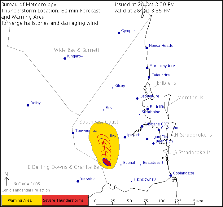
Other archives: 2004 | 2006 | 2007 | 2008 Monday 7 November Graphical thunderstorm warnings similar to those introduced for Sydney last December will be available for residents of Brisbane and QLD from 1 December. There are two graphics that will accompany the familiar text warnings. The first shows areas affected by current thunderstorm warnings anywhere in the state, like this sample (click for full sized view):
The second, which will be available only for SE QLD, shows the current position and forecast movement of severe thunderstorm cells, like this sample:
Thursday 6 October Two new Bureau radar installations are due to come online in the next few weeks. The installation at Tennant Creek in the NT will fill an enormous gap in northern Australian radar coverage. Currently the nearest radars are at Tindal (Katherine) to the north, Alice Springs to the south, Halls Creek to the west and Mornington Island and Longreach to the east. Tennant Creek radar is expected to be available from 19 October. The first of six enhanced Doppler radars in the Bureau's current $62.2m radar upgrade will begin operation at Buckland Park, Adelaide, on 28 October. Details of this new installation are here. Wednesday 14 September The Bureau's subscription radar service 512km radius images have now been upgraded to use the same 16 level rain scale and topographic backgrounds as the 128 and 256km images. 512km radius images are composites from all available radars within the frame and, like the other subscription service radars, present the seven most recent frames in an animation. While this enhancement is welcome, the Bureau's online radar service at an annual subscription of $649.80 still presents an unattractive alternative to Weatherzone's $5.00 per month subscription which includes state and national radar compilations with animations that can be tailored out to the 50 most recent frames, as well as a wide range of other products. Tuesday 16 August The Bureau has introduced a page on its website detailing new products and products in development. The Notification Page is still under development and is fairly technical, but will be a useful resource for those watching for the many new items the Bureau proposes for its website in coming months. Tuesday
19 July From today, the Bureau has added apparent temperature calculations to its real-time AWS thermal comfort pages for each state. These now show a "feels like" temperature -- wind chill when temperatures are below 20C, heat stress when they rise above 20C. The wind chill calculation takes into account the effects of wind and humidity in decreasing the apparent temperature while the heat stress acknowledges that warm humid air is more stressful than dry warm air at the same actual temperature. The apparent temperature calculations add to the wet bulb globe temperature calculations that have been available for a while. These also are an estimation of heat stress, and are used especially by sporting organisations in making decisions about activities. The apparent temperature figures are likely to appeal to an even wider section of the community. For lots of information about how the wind chill, heat stress and wet bulb globe temperatures are calculated and used, see the Bureau's explanatory notes. Some burrowing is required to find them on the Bureau's site -- click on the state link, then the weather observations link, then look for Thermal comfort observations in the list. Alternatively, use the AWN Current Weather Reports matrix. To get there by menu, click Current > Observations. Saturday
2 July Subscribers to Bureau radar products will find that the broadscale 512km radius images will be upgraded to the same 16-colour rain scale and topographic backgrounds as the 128 and 256km images from early August. Friday
1 July From 12 July, the Bureau's Weather by Fax service will increase in price from 60c to $1.38. Once cutting-edge technology, this Bureau service has been replaced by the Internet for many users, leaving a dwindling base of users to cover costs. Monday
28 June The new geostationary MTSAT-1R satellite became operational for Australia today with the Bureau's 2pm EST charts the first to appear routinely from the new source. The satellite, which is owned and operated by the Japanese Meteorological Agency, provides images freely to Australia as part of the international co-operative arrangements in meteorology. Hourly full-disc images are received by Crib Point Satellite Earth Station, located in HMAS Cerberus on Mornington Peninsula, VIC, and are processed using new Bureau-designed technology. MTSAT-1R replaces the American GOES-9 which was temporarily moved to cover the Australian region when GOES-5 failed last year. Friday
13 May For avid Bureau-watchers, the Bureau's Annual Report for 2003/4 is now available on the web, here. Thursday
28 April The Bureau's 'Latest Weather Observations' pages have been given a makeover. The tables of data have many improvements and are a major step towards national consistency, but the greatest addition is clickable map access to the current and past 3 days data for each station. Not only does this make for easy access, but it also shows the geographically challenged among us just where the weather stations are. The maps are in the same style as the new radar and clickable forecast topographic backgrounds, and show forecast district and every available station. The tables now have stations grouped by district, with quick access via a district index at the top. Automatic and manual observations are all in together, with the problem of different reporting schedules deftly managed by the use of italics and a faded blue-green type for older observations. The 3-day histories can still be accessed by clicking the station name. An announcement detailing the changes is here, and a help page is here. The new tables and maps can be accessed from each state's observations page on the Bureau's site, or by using the quick links page on Australian Weather News -- here. Friday 11 March The Bureau today released details of manual weather stations to be closed or to have their observing programs cut back from next Wednesday (see earlier story below). There are some surprise closures: Monto AP, QLD: The airport site only goes back to 1993, but combined with the nearby PO site stretches back to 1930. This is an agriculturally important part of QLD, so leaving it without effective climatic monitoring is surprising -- the nearest alternative is Thangool Airport 70km away. Cape Northumberland, SA: This is the biggest loss of all. The station is one of the oldest in SA, opening in October 1864. The nearest alternative, Mt Gambier, is 36km away, gives no sea reports, and is quite different climatically. Port Arthur (Palmers Lookout), TAS: This leaves the oceanic (and temperamental) Tasman Island AWS as the only source of weather information SE of a line from Hobart Airport to the 9 & 3-reporting station at Orford. Lists of stations to be closed or cut back are given in this Bureau anouncement. There are still 9 stations to be determined, and they will be added to the cutback list when negotiations with observers are completed. The reduced schedules will mean that only a handful of the detailed manual synoptic observations will be available at the 3am, noon, 6pm and 9pm observations. This is in contrast to North and South America, Europe and Asia -- a quick check of AWN's international synoptic charts shows the density of their manual observation networks at all main observations of the day (all plots with circles are manual). The brunt of the trimming appears to have been borne in remote areas of WA, NT, SA and QLD at locations where there are no replacing automatic weather stations. Here, many stations that have provided between 5 and 7 observations daily are being reduced to 3. Included is the stalwart QLD post office network. In the earliest days of weather observation it was the post offices that did the job across Australia, mainly because only they had the means to quickly telegraph observations to the Bureau. It was these beginnings that made 9am the main observation of the day nationally, because that was when the post offices opened for business and the observer used the transmission of the observation to check that the telegraph line was working. The post office observing tradition has been kept alive in QLD, but the post offices at Burketown, Clermont, Collinsville, Cunnamulla and Gayndah have been reduced to 2 or 3 observations a day, and those at Georgetown, Injune, St Lawrence and Windorah have been trimmed. The reductions also mean substantial cuts in the payments that observers receive. The long-term questions now are how long those in long-standing, climatically important stations will remain committed to their tasks, and whether the Bureau is developing a management strategy that integrates the best features of both manual and automatic weather stations for successful monitoring of both realtime weather and long-term climate. Tuesday 8 March From 9am EDT, the Bureau's popular radar images show 16 rather than 7 levels of rainfall intensity, accompanied by a major change to graphics and the colour palette that indicates rainfall intensity. Details of the 16 levels (really only 15 levels, plus a level for "so light it doesn't matter") are given about halfway down the Bureau's Radar Interpretation page, along with approximate rainfall rates and reflectivity figures. The background maps have been greatly improved, with contours showing elevation and many more towns and locations added to help place rainfall echoes. The colour palette used to show different levels of reflectivity seems quirky at first, but is designed to give good differentiation between adjacent colour bands, help the visually impaired, and work with the lighter colour maps (printing them is a great improvement on the old, dark backgrounds). Radar is the single most-used section of the Bureau's website, accounting for 70% of the 44 terabytes of data it delivered to users in 2004. Thursday 10 February With ever-increasing expenditure on automatic weather stations and new technology for remotely sensing the weather, it was only a matter of time before the Bureau had to apply the financial razor to its burgeoning observations budget. It will be felt on 16 March by hundreds of human observers when the Bureau's "manual" observations program receives its biggest one-off reduction in decades. Announcing the changes on Monday, Acting Director of Meteorology, Dr Bob Brook, said "Over many decades manual weather observers have made a valuable contribution to the national observing network and will continue to be an important part of the Bureau's delivery of weather services to the Australian community. However, the relative importance of manual observations has declined due to the emergence of automatic weather stations, weather watch radars and satellites." Currently the Bureau supports 542 automatic weather stations and 334 manual observer stations. The observing program at 171 of the manual stations will continue unchanged, but the vast majority of these are already reporting only at 9am and 3pm. 18 stations will be closed, mostly those that duplicate nearby AWSs and have been kept going to establish comparison data between the two. That leaves 145 sites where the observation program will be cut back to 9am and 3pm, with an additional 6am observation in locations of aeronautical importance. A similar pruning will take place at a number of AWSs that currently have human input for visual observations -- cloud, visibility and type of present and past weather. In effect, this means that from 16 March human observations will only be made at the standard 3-hourly synoptic intervals at a handful of Bureau-staffed stations in capital cities and at a few isolated locations where AWSs have not been installed. There are a further 50 or so Bureau staffed stations, mostly at major country airports, where manual observations are typically taken 4 or 5 times a day. The remaining 316 stations will report at 9am and 3pm with some also reporting at 6am. Pros and cons The gradual replacement of manual observers with AWSs that began in the 1980s has brought more pluses than minuses. AWSs don't get ill or miss the odd observation, and happily transmit observations hourly or more frequently 24/7. While they provide only temperature, humidity, rainfall, wind and (in most cases) pressure readings, it can be argued that the three primary visual observations added by the human observer will not be missed: the detailed cloud observation is superseded by satellite images, visibility is being directly measured at an increasing number of AWSs and can be inferred from humidity, and the type of present and past weather can also sometimes be inferred from the rest of the observation. The big minus with AWSs is that they sometimes stop working, and sometimes this is for several days or a week at a time. Mt Boyce in the Blue Mountains of NSW, for example, fell victim to lightning or power surges on 3 occasions in January and consequently missed 10 out of 31 days observations. Because these coincided with major storm falls, Mt Boyce shows a January rainfall total of 18mm. Nearby stations suggest the total should have been around 260mm. The station's monthly (and annual) rainfall total is therefore unusable for climatic purposes, and of course there is no record at all of the weather for one-third of January. Fortunately, Katoomba manual station is only 11km away (but presumably about to be cut back), and there are several nearby daily-reporting raingauges, so the record can, to an extent, be reconstructed. Places like Tamworth and Port Macquarie, however, are not so fortunate. There are no nearby daily reporting climatic or rainfall stations, so when the AWS is down the city is left with no climatic record at all. In recent months, Tamworth was out of action for 8 days in December and 6 days between last June and October. Port Macquarie was out for 4 days last August and 2 in January. These aren't isolated examples, and don't even begin to explore problems of erroneous data due to computer resets and other issues. In preparing this article, I spoke with several highly-placed people in the Bureau. None could confirm that there was a backup strategy to prevent these holes in the official weather and climatic record for major centres other than the hope that the improvement in technology that is driving this process will also produce a more reliable AWS. Thursday 6 January The Bureau's annual summary is now available for 2004, and shows the year was the tenth warmest since reliable national temperature figures became available in 1910. Meantime, an annual review from the NSW Regional Office shows that Sydney had its hottest year in 146 years of record, with an average maximum temperature 2.0C above the norm. |