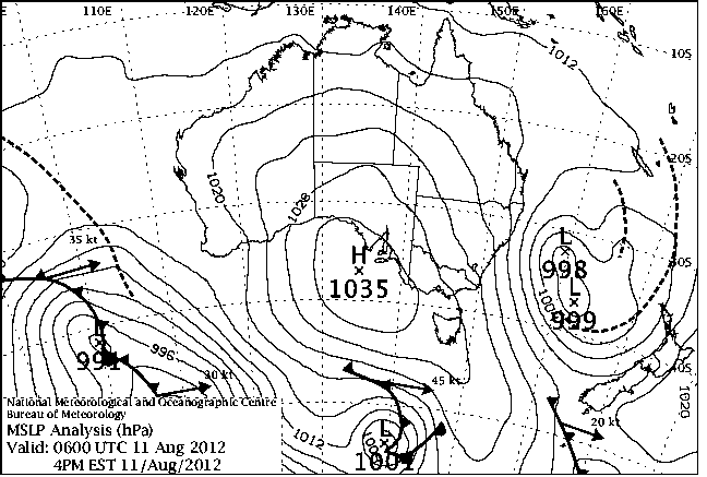
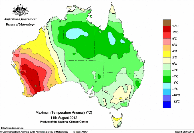
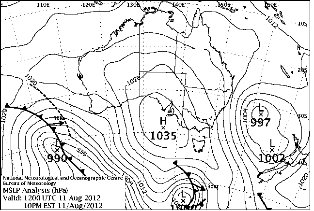
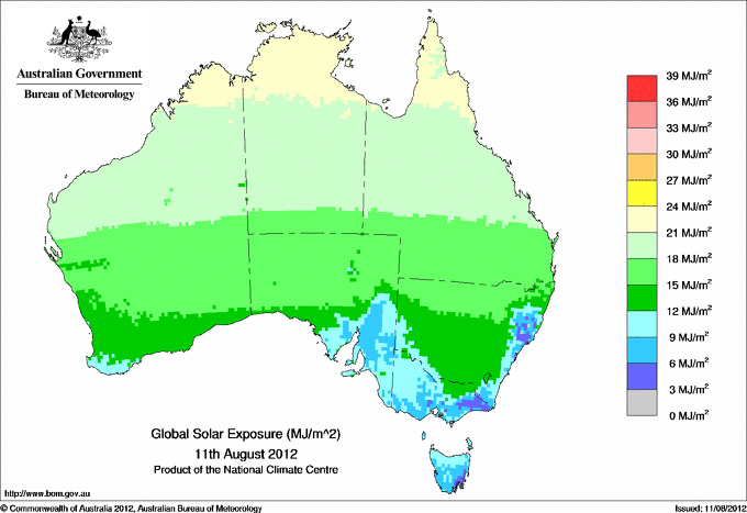
|
For notes on how to interpret
the data and quality control issues, see Daily Weather Summary Help.
**S** and **W** precede data flagged by the Bureau as suspicious or wrong
Data is as received at 03:30EST, 20/04/2013.
|
|
| |
Max
°
C |
+/- norm
°
C |
Min
°
C |
+/- norm
°
C |
Grass Min
°
C |
Rain to 9am mm |
Evaporation to 9am mm |
Sunshine hours |
Wind Run to 9am km (24-hour average km/h) |
Maximum Gust km/h / hour of occurrence |
| GERALDTON AIRPORT COMPARISON |
22.8 |
+2.8 |
7.7 |
-1.2 |
-- |
0.0 |
-- |
-- |
221 ( 9.2) |
30/08 |
| PERTH AIRPORT |
24.5 |
+6.0 |
7.5 |
-0.5 |
5.3 |
0.0 |
3.0 |
8.4 |
291 (12.1) |
30/05 |
| ALBANY AIRPORT COMPARISON |
21.9 |
+5.8 |
7.0 |
-0.5 |
-- |
0.0 |
-- |
-- |
236 ( 9.8) |
24/12 |
| BUNBURY |
19.4 |
+1.9 |
4.8 |
-2.7 |
-- |
0.0 |
-- |
-- |
131 ( 5.5) |
18/10 |
| MANDURAH |
19.3 |
+1.5 |
10.5 |
-0.3 |
-- |
0.0 |
-- |
-- |
200 ( 8.3) |
24/23 |
| DARWIN AIRPORT |
31.6 |
+0.2 |
17.7 |
-2.7 |
15.3 |
0.0 |
7.4 |
11.1 |
358 (14.9) |
48/10 |
| ALICE SPRINGS AIRPORT |
18.1 |
-4.5 |
-1.7 |
-7.7 |
-3.7 |
0.0 |
7.6 |
10.8 |
302 (12.6) |
41/11 |
| WHYALLA AERO |
14.5 |
-4.0 |
9.2 |
+3.3 |
-- |
0.0 |
3.8 |
-- |
337 (14.0) |
31/16 |
| ADELAIDE (KENT TOWN) |
14.2 |
-2.4 |
5.4 |
-2.8 |
-- |
0.0 |
-- |
-- |
114 ( 4.8) |
30/13 |
| MOUNT GAMBIER AERO |
14.4 |
+0.3 |
6.5 |
+1.0 |
3.5 |
1.4 |
1.2 |
3.0 |
291 (12.1) |
46/11 |
| MOUNT ISA AERO |
22.4 |
-4.9 |
10.2 |
-0.1 |
-- |
0.0 |
-- |
-- |
482 (20.1) |
52/15 |
| CAIRNS AERO |
23.9 |
-2.7 |
15.5 |
-1.9 |
11.4 |
0.0 |
7.4 |
11.1 |
341 (14.2) |
46/09 |
| TOWNSVILLE AERO |
22.8 |
-3.2 |
12.2 |
-2.5 |
6.0 |
0.0 |
8.4 |
11.0 |
484 (20.2) |
37/06 |
| MACKAY M.O |
19.1 |
-3.5 |
9.5 |
-4.5 |
-- |
0.0 |
-- |
11.0 |
385 (16.0) |
46/00 |
| ROCKHAMPTON AERO |
22.2 |
-2.6 |
7.2 |
-3.5 |
2.0 |
0.0 |
8.4 |
-- |
471 (19.6) |
35/09 |
| BUNDABERG AERO |
21.2 |
-2.1 |
8.4 |
-2.5 |
-- |
0.0 |
-- |
-- |
424 (17.7) |
50/21 |
| COOLANGATTA |
20.2 |
-1.1 |
10.6 |
+0.2 |
-- |
0.0 |
-- |
-- |
332 (13.8) |
48/09 |
| BRISBANE AERO |
20.8 |
-0.9 |
8.1 |
-1.5 |
3.8 |
0.0 |
7.0 |
10.2 |
555 (23.1) |
43/10 |
| TOOWOOMBA AIRPORT |
15.6 |
-2.9 |
2.4 |
-5.1 |
-- |
0.0 |
-- |
-- |
601 (25.0) |
37/14 |
| GUNNEDAH RESOURCE CENTRE |
16.6 |
-1.3 |
5.2 |
-0.6 |
0.0 |
0.0 |
3.0 |
-- |
199 ( 8.3) |
-- |
| COFFS HARBOUR MO |
17.8 |
-2.0 |
8.8 |
+0.5 |
7.0 |
11.5 |
6.3 |
-- |
743 (31.0) |
67/10 |
| PORT MACQUARIE AIRPORT AWS |
15.9 |
-4.3 |
8.7 |
+1.9 |
-- |
14.4 |
-- |
-- |
643 (26.8) |
57/09 |
| WILLIAMTOWN RAAF |
14.7 |
-3.9 |
7.7 |
+0.8 |
-- |
23.2 |
-- |
-- |
737 (30.7) |
68/14 |
| GOSFORD (NARARA RESEARCH STATION) AWS |
15.6 |
-3.4 |
9.0 |
+3.6 |
-- |
8.0 |
-- |
-- |
196 ( 8.2) |
43/15 |
| ORANGE AGRICULTURAL INSTITUTE |
10.2 |
-0.8 |
-0.4 |
-2.5 |
-7.4 |
0.2 |
2.4 |
7.9 |
-- |
-- |
| DUBBO AIRPORT AWS |
17.1 |
-0.4 |
-1.9 |
-5.4 |
-- |
0.0 |
-- |
-- |
257 (10.7) |
39/15 |
| SYDNEY AIRPORT AMO |
14.6 |
-3.7 |
10.0 |
+1.9 |
9.2 |
3.2 |
5.9 |
1.5 |
1245 (51.9) |
80/13 |
| RICHMOND RAAF |
18.2 |
-1.5 |
7.5 |
+3.1 |
-- |
0.0 |
-- |
-- |
437 (18.2) |
50/11 |
| BELLAMBI AWS |
15.6 |
-2.4 |
11.3 |
+0.8 |
-- |
0.0 |
-- |
-- |
1162 (48.4) |
83/13 |
| WAGGA WAGGA AMO |
15.9 |
+1.4 |
-0.8 |
-4.4 |
-2.9 |
0.0 |
2.4 |
10.0 |
354 (14.8) |
35/21 |
| ALBURY AIRPORT AWS |
16.6 |
+1.6 |
-0.7 |
-4.5 |
-- |
0.0 |
-- |
-- |
177 ( 7.4) |
24/22 |
| MILDURA AIRPORT |
17.0 |
-0.3 |
6.5 |
+1.2 |
1.0 |
0.0 |
2.6 |
-- |
338 (14.1) |
41/15 |
| TATURA INST SUSTAINABLE AG |
14.7 |
0.0 |
6.0 |
+2.1 |
-- |
0.0 |
-- |
-- |
472 (19.7) |
52/12 |
| BENDIGO AIRPORT |
14.1 |
-0.2 |
1.9 |
-0.7 |
-- |
0.0 |
-- |
-- |
305 (12.7) |
48/14 |
| MELBOURNE REGIONAL OFFICE |
15.5 |
+0.5 |
9.6 |
+2.9 |
-- |
2.8 |
-- |
-- |
-- |
-- |
| BALLARAT AERODROME |
11.6 |
+0.2 |
6.0 |
+2.3 |
-- |
0.8 |
-- |
-- |
487 (20.3) |
�
48/10 |
| LAUNCESTON (TI TREE BEND) |
15.7 |
+1.9 |
-0.8 |
-4.5 |
-- |
0.0 |
-- |
-- |
56 ( 2.3) |
26/14 |
| HOBART AIRPORT |
10.6 |
-2.9 |
5.7 |
+1.0 |
3.4 |
0.2 |
1.4 |
0.3 |
291 (12.1) |
30/13 |
| |
Max
°
C |
+/- norm
°
C |
Min
°
C |
+/- norm
°
C |
Grass Min
°
C |
Rain to 9am mm |
Evaporation to 9am mm |
Sunshine hours |
Wind Run to 9am km |
Maximum Gust km/h / hour of occurrence |
|
| Hottest |
| Highest maximum temperature> | Greatest variation above normal maximum |
Highest minimum temperature | Greatest variation above normal minimum |
34.9 MARDIE W Pilbara WA
34.9 EMU CREEK STATION W Gascoyne WA
34.2 CURTIN AERO W Kimberley WA
34.0 ONSLOW AIRPORT W Pilbara WA
34.0 MANDORA E Pilbara WA
|
+11.3 : 28.7 HYDEN Cent Wheatbelt WA
+11.1 : 28.4 MERREDIN Cent Wheatbelt WA
+11.1 : 28.3 RAVENSTHORPE Cent Wheatbelt WA
+10.9 : 30.8 PAYNES FIND E Gascoyne WA
+10.8 : 29.7 HOPETOUN NORTH Lower West WA
+10.8 : 28.4 BENCUBBIN Cent Wheatbelt WA
|
25.3 COCOS ISLAND AIRPORT Islands ISL
**S** 23.0 BEDOUT ISLAND E Pilbara WA
22.7 COCONUT ISLAND N Peninsula QLD
22.7 CHRISTMAS ISLAND AERO Islands ISL
22.4 MCCLUER ISLAND N Rivers NT
|
+9.6 : 12.9 SOUTHERN CROSS AIRFIELD Goldfields WA
+8.3 : 13.7 MERREDIN Cent Wheatbelt WA
**S** +7.9 : 14.5 WONGAN HILLS Central West WA
+7.2 : 13.0 BENCUBBIN Cent Wheatbelt WA
+6.4 : 10.5 NORSEMAN AERO Goldfields WA
|
| Coldest |
| Lowest maximum temperature | Greatest variation below normal maximum |
Lowest minimum temperature | Greatest variation below normal minimum |
-1.5 THREDBO AWS Snowy Mtns NSW
-1.4 MOUNT HOTHAM Upper NE VIC
-0.3 FALLS CREEK Upper NE VIC
-0.1 MOUNT BULLER Upper NE VIC
**S** 0.0 CHARLOTTE PASS (KOSCIUSKO CHALET) Snowy Mtns NSW
|
-6.8 : 24.5 ELLIOTT N Plateau NT
-6.6 : 13.4 TAREE AIRPORT AWS MidNorth Coast S NSW
-6.5 : 22.0 RICHMOND POST OFFICE Upper Carpentaria QLD
-6.5 : 20.1 CHARTERS TOWERS AIRPORT Central Coast W QLD
-6.4 : 23.2 BRUNETTE DOWNS N Plateau NT
-6.4 : 22.6 RICHMOND AIRPORT Upper Carpentaria QLD
|
-8.0 CHARLOTTE PASS (KOSCIUSKO CHALET) Snowy Mtns NSW
-6.4 GOULBURN AIRPORT AWS Goulburn/Monaro NSW
-4.9 THREDBO AWS Snowy Mtns NSW
-4.9 MOUNT HOTHAM Upper NE VIC
-4.5 YOUNG AIRPORT SW Slopes N NSW
|
**S** -11.2 : 1.6 WAVE HILL N Rivers NT
-10.5 : 1.3 PROSERPINE AIRPORT Central Coast E QLD
-9.2 : 6.5 CROYDON TOWNSHIP Gulf Country QLD
-9.2 : 0.8 EMERALD AIRPORT Central Highlands QLD
-9.1 : 1.4 HUGHENDEN AIRPORT Upper Carpentaria QLD
|
|
Sunniest &
dullest |
Windiest |
Highest gusts |
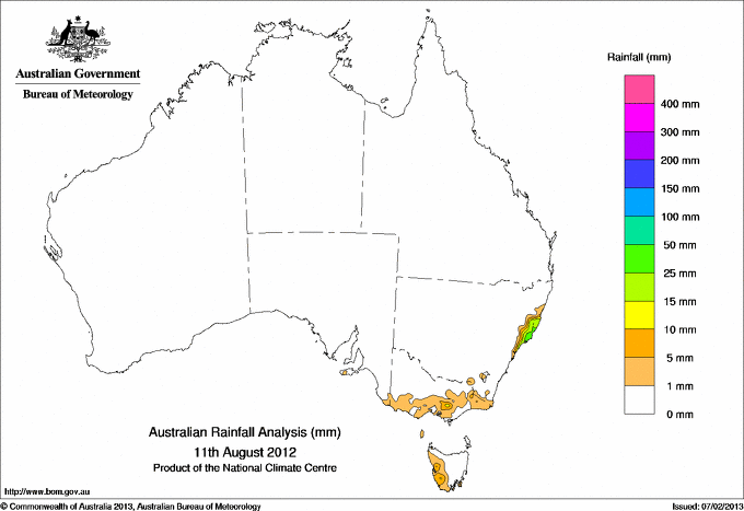
Todays highest rainfall totals for the 24 hours to 9am. It
includes the top 5 totals nationally followed by all reported falls of 50mm or more. |
Highest
and lowest recordings of hours of sunshine for the 24 hours to midnight. |
Highest wind
run totals in kilometres for the 24 hours to 9am (average speed in brackets).
All reported runs >
=25km/h are shown. |
Highest wind
gusts in km/h for the 24 hours to midnight followed by the hour in which it occurred.
All stations with gusts >
89km/h are shown. |
70.0 COMBOYNE PUBLIC SCHOOL MidNorth Coast S NSW
67.0 WOOTTON MidNorth Coast S NSW
46.0 WILLINA MidNorth Coast S NSW
41.0 BUNGWAHL MidNorth Coast S NSW
39.2 WHOOTA MidNorth Coast S NSW
NEW SOUTH WALES
MidNorth Coast S
70.0 COMBOYNE PUBLIC SCHOOL
67.0 WOOTTON
46.0 WILLINA
41.0 BUNGWAHL
39.2 WHOOTA
|
11.1 DARWIN AIRPORT N Rivers NT
11.1 TENNANT CREEK AIRPORT N Plateau NT
11.1 CAIRNS AERO N Coast--Barron QLD
11.0 TOWNSVILLE AERO N Coast--Herbert QLD
11.0 MACKAY M.O Central Coast E QLD
.....
1.8 ADELAIDE AIRPORT Adelaide/Lofty SA
1.5 SYDNEY AIRPORT AMO Sydney--east NSW
0.9 GROVE (RESEARCH STATION) Southeast TAS
0.6 NURIOOTPA VITICULTURAL Adelaide/Lofty SA
0.3 HOBART AIRPORT Southeast TAS
|
1303 (54.3) GABO ISLAND LIGHTHOUSE E Gippsland VIC
1297 (54.0) SYDNEY HARBOUR (WEDDING CAKE WEST) Sydney--east NSW
1273 (53.0) MONTAGUE ISLAND LIGHTHOUSE South Coast NSW
1267 (52.8) KIAMA (BOMBO HEADLAND) Illawarra NSW
1245 (51.9) SYDNEY AIRPORT AMO Sydney--east NSW
1209 (50.4) FALLS CREEK Upper NE VIC
1187 (49.5) GREEN CAPE AWS South Coast NSW
1162 (48.4) BELLAMBI AWS Illawarra NSW
1137 (47.4) MOUNT WELLINGTON Southeast TAS
1050 (43.8) WILSONS PROMONTORY LIGHTHOUSE W Gippsland VIC
**S** 1037 (43.2) MOUNT BULLER Upper NE VIC
1008 (42.0) JERVIS BAY (POINT PERPENDICULAR AWS) Illawarra NSW
995 (41.5) CAPE GRIM BAPS (COMPARISON) N Coast TAS
951 (39.6) NORAH HEAD AWS Hunter Valley NSW
912 (38.0) MIDDLE PERCY ISLAND Islands ISL
880 (36.7) HARTZ MOUNTAIN (KEOGHS PIMPLE) Southeast TAS
874 (36.4) ULLADULLA AWS South Coast NSW
863 (36.0) ALBION PARK (WOLLONGONG AIRPORT) Illawarra NSW
849 (35.4) MOUNT READ W Coast TAS
845 (35.2) GRAMPIANS (MOUNT WILLIAM) Wimmera S VIC
834 (34.8) MAATSUYKER ISLAND LIGHTHOUSE Southeast TAS
822 (34.3) HOGAN ISLAND Islands ISL
802 (33.4) BYRON BAY (CAPE BYRON AWS) North Coast NSW
801 (33.4) NEWCASTLE NOBBYS SIGNAL STATION AWS Hunter Valley NSW
755 (31.5) CAPE GRIM N Coast TAS
754 (31.4) MOUNT GININI AWS Goulburn/Monaro NSW
753 (31.4) HAMILTON ISLAND AIRPORT Central Coast E QLD
751 (31.3) WILLIS ISLAND Islands ISL
746 (31.1) PORT KEMBLA NTC AWS Illawarra NSW
743 (31.0) COFFS HARBOUR MO MidNorth Coast N NSW
737 (30.7) WILLIAMTOWN RAAF Hunter Valley NSW
730 (30.4) LADY ELLIOT ISLAND Wide Bay/Burnett QLD
725 (30.2) CAPE BRUNY (CAPE BRUNY) Southeast TAS
723 (30.1) RUNDLE ISLAND Wide Bay/Burnett QLD
706 (29.4) DOUBLE ISLAND POINT LIGHTHOUSE Brisbane/SE Coast QLD
685 (28.5) CAPE WESSEL Islands ISL
672 (28.0) COOMA AIRPORT AWS Goulburn/Monaro NSW
671 (28.0) MCCLUER ISLAND N Rivers NT
671 (28.0) KEMPSEY AIRPORT AWS MidNorth Coast N NSW
647 (27.0) CAPE MORETON LIGHTHOUSE Brisbane/SE Coast QLD
643 (26.8) PORT MACQUARIE AIRPORT AWS MidNorth Coast S NSW
641 (26.7) HERON ISLAND RES STN Wide Bay/Burnett QLD
635 (26.5) CAPE OTWAY LIGHTHOUSE W Coast VIC
632 (26.3) WALLAN (KILMORE GAP) N Central VIC
624 (26.0) TASMAN ISLAND Southeast TAS
620 (25.8) CENTRE ISLAND N Rivers NT
607 (25.3) COCOS ISLAND AIRPORT Islands ISL
601 (25.0) TOOWOOMBA AIRPORT Darling Downs E QLD
600 (25.0) MOSS VALE AWS Illawarra NSW
|
91/17 NORAH HEAD AWS Hunter Valley NSW
87/13 NEWCASTLE NOBBYS SIGNAL STATION AWS Hunter Valley NSW
87/12 KIAMA (BOMBO HEADLAND) Illawarra NSW
85/16 SYDNEY HARBOUR (WEDDING CAKE WEST) Sydney--east NSW
83/13 BELLAMBI AWS Illawarra NSW
83/11 ALBION PARK (WOLLONGONG AIRPORT) Illawarra NSW
83/01 MOUNT BULLER Upper NE VIC
|
�