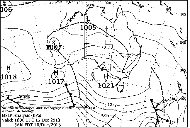
|
For notes on how to interpret
the data and quality control issues, see Daily Weather Summary Help.
**S** and **W** precede data flagged by the Bureau as suspicious or wrong
Data is as received at 16:12EST, 16/12/2013.
|
|
| |
Max
°
C |
+/- norm
°
C |
Min
°
C |
+/- norm
°
C |
Grass Min
°
C |
Rain to 9am mm |
Evaporation to 9am mm |
Sunshine hours |
Wind Run to 9am km (24-hour average km/h) |
Maximum Gust km/h / hour of occurrence |
| GERALDTON AIRPORT COMPARISON |
40.7 |
+11.1 |
17.5 |
+1.1 |
-- |
0.0 |
-- |
-- |
291 (12.1) |
39/16 |
| PERTH AIRPORT |
38.3 |
+9.4 |
15.7 |
+0.8 |
13.6 |
0.0 |
12.0 |
13.2 |
325 (13.5) |
35/14 |
| ALBANY AIRPORT COMPARISON |
27.6 |
+4.5 |
14.0 |
+1.5 |
-- |
0.0 |
-- |
-- |
241 (10.0) |
39/12 |
| BUNBURY |
36.8 |
+9.5 |
16.8 |
+3.2 |
-- |
0.0 |
-- |
-- |
213 ( 8.9) |
35/18 |
| MANDURAH |
35.9 |
+9.0 |
21.4 |
+4.2 |
-- |
0.0 |
-- |
-- |
258 (10.8) |
34/16 |
| DARWIN AIRPORT |
34.0 |
+1.4 |
23.8 |
-1.5 |
23.7 |
6.0 |
6.4 |
9.8 |
337 (14.0) |
41/20 |
| ALICE SPRINGS AIRPORT |
36.7 |
+1.3 |
17.9 |
-2.3 |
15.5 |
0.0 |
14.8 |
10.7 |
337 (14.0) |
46/09 |
| WHYALLA AERO |
28.0 |
-0.2 |
14.0 |
-1.9 |
-- |
0.0 |
-- |
-- |
520 (21.7) |
52/17 |
| ADELAIDE (KENT TOWN) |
27.1 |
+0.1 |
10.9 |
-4.7 |
-- |
0.0 |
-- |
13.3 |
193 ( 8.0) |
37/17 |
| MOUNT GAMBIER AERO |
20.9 |
-2.0 |
6.7 |
-3.3 |
4.8 |
0.0 |
6.4 |
10.9 |
276 (11.5) |
31/12 |
| MOUNT ISA AERO |
38.9 |
+1.8 |
21.2 |
-1.8 |
-- |
0.0 |
-- |
-- |
231 ( 9.6) |
65/16 |
| CAIRNS AERO |
32.7 |
+1.3 |
24.3 |
+0.9 |
23.1 |
2.2 |
6.2 |
6.8 |
327 (13.6) |
44/15 |
| TOWNSVILLE AERO |
32.9 |
+1.4 |
24.2 |
+0.1 |
22.0 |
0.6 |
9.4 |
12.3 |
461 (19.2) |
43/14 |
| MACKAY M.O |
30.8 |
+0.7 |
21.6 |
-1.4 |
-- |
0.0 |
-- |
11.5 |
320 (13.3) |
35/14 |
| ROCKHAMPTON AERO |
32.6 |
+0.5 |
21.3 |
+0.1 |
20.3 |
0.0 |
9.0 |
-- |
288 (12.0) |
34/13 |
| BUNDABERG AERO |
30.7 |
+1.2 |
20.0 |
-0.5 |
-- |
0.0 |
-- |
-- |
268 (11.2) |
39/15 |
| COOLANGATTA |
27.7 |
+0.5 |
20.9 |
+1.0 |
-- |
0.0 |
-- |
-- |
239 (10.0) |
28/13 |
| BRISBANE AERO |
29.4 |
+1.3 |
21.5 |
+1.4 |
18.2 |
0.0 |
8.0 |
10.7 |
359 (15.0) |
37/16 |
| TOOWOOMBA AIRPORT |
30.0 |
+2.6 |
16.9 |
+0.3 |
-- |
0.0 |
-- |
-- |
507 (21.1) |
55/20 |
| GUNNEDAH RESOURCE CENTRE |
34.3 |
+3.4 |
18.0 |
+0.5 |
-- |
0.0 |
10.6 |
-- |
238 ( 9.9) |
-- |
| COFFS HARBOUR MO |
25.7 |
-0.6 |
17.8 |
-0.3 |
11.7 |
0.4 |
4.0 |
-- |
414 (17.3) |
48/00 |
| PORT MACQUARIE AIRPORT AWS |
25.9 |
-0.6 |
17.8 |
+1.0 |
-- |
1.2 |
-- |
-- |
157 ( 6.5) |
34/14 |
| WILLIAMTOWN RAAF |
26.1 |
-1.1 |
15.5 |
-1.0 |
-- |
0.0 |
-- |
-- |
392 (16.3) |
37/16 |
| ORANGE AGRICULTURAL INSTITUTE |
26.5 |
+2.2 |
10.7 |
-0.5 |
3.5 |
0.0 |
7.4 |
13.0 |
-- |
-- |
| DUBBO AIRPORT AWS |
34.1 |
+2.9 |
16.9 |
+1.1 |
-- |
0.0 |
-- |
-- |
402 (16.8) |
37/06 |
| SYDNEY AIRPORT AMO |
24.3 |
-1.4 |
18.3 |
+0.8 |
17.5 |
6.0 |
7.8 |
2.0 |
520 (21.7) |
37/18 |
| RICHMOND RAAF |
27.3 |
-1.1 |
17.7 |
+1.7 |
-- |
0.0 |
-- |
-- |
248 (10.3) |
37/15 |
| BELLAMBI AWS |
20.4 |
-3.4 |
17.5 |
+0.1 |
-- |
31.0 |
-- |
-- |
406 (16.9) |
41/15 |
| WAGGA WAGGA AMO |
31.8 |
+2.4 |
12.6 |
-1.2 |
10.6 |
0.0 |
11.2 |
12.9 |
344 (14.3) |
39/16 |
| ALBURY AIRPORT AWS |
31.1 |
+1.9 |
12.8 |
-1.0 |
-- |
0.0 |
-- |
-- |
210 ( 8.8) |
41/15 |
| MILDURA AIRPORT |
30.6 |
+0.5 |
13.1 |
-1.7 |
9.7 |
0.0 |
9.0 |
12.1 |
328 (13.7) |
34/12 |
| TATURA INST SUSTAINABLE AG |
28.3 |
+0.9 |
-- |
-- |
-- |
0.0 |
-- |
-- |
-- |
41/16 |
| BENDIGO AIRPORT |
29.1 |
+2.1 |
10.0 |
-1.6 |
-- |
0.0 |
-- |
-- |
364 (15.2) |
37/17 |
| MELBOURNE REGIONAL OFFICE |
21.7 |
-2.5 |
14.0 |
+1.1 |
-- |
0.0 |
-- |
-- |
-- |
-- |
| BALLARAT AERODROME |
22.0 |
-0.6 |
6.9 |
-2.5 |
-- |
0.2 |
-- |
-- |
409 (17.0) |
34/16 |
| LAUNCESTON (TI TREE BEND) |
25.2 |
+2.8 |
10.9 |
+0.3 |
-- |
0.0 |
-- |
-- |
258 (10.8) |
�
28/15 |
| HOBART AIRPORT |
22.5 |
+1.8 |
12.5 |
+1.8 |
9.8 |
0.0 |
4.0 |
9.6 |
457 (19.0) |
43/14 |
| |
Max
°
C |
+/- norm
°
C |
Min
°
C |
+/- norm
°
C |
Grass Min
°
C |
Rain to 9am mm |
Evaporation to 9am mm |
Sunshine hours |
Wind Run to 9am km |
Maximum Gust km/h / hour of occurrence |
|
| Hottest |
| Highest maximum temperature> | Greatest variation above normal maximum |
Highest minimum temperature | Greatest variation above normal minimum |
44.8 YORK Cent Wheatbelt WA
44.7 NORTHAM Cent Wheatbelt WA
44.6 BENCUBBIN Cent Wheatbelt WA
44.4 CARNAMAH Central West WA
44.2 BEVERLEY Cent Wheatbelt WA
|
+18.0 : 42.1 HOPETOUN NORTH Lower West WA
+17.8 : 43.8 JACUP Cent Wheatbelt WA
+15.0 : 39.6 ESPERANCE Lower West WA
+14.8 : 41.9 ONGERUP Cent Wheatbelt WA
+14.4 : 40.1 ESPERANCE AERO Lower West WA
+14.4 : 41.6 RAVENSTHORPE Cent Wheatbelt WA
|
29.2 CAPE DON N Rivers NT
29.2 TROUGHTON ISLAND N Kimberley WA
28.7 MCCLUER ISLAND N Rivers NT
28.6 NGAYAWILI N Rivers NT
28.5 HARVEY Lower West WA
|
+15.1 : 28.5 HARVEY Lower West WA
+11.2 : 24.0 RAVENSTHORPE Cent Wheatbelt WA
+8.5 : 22.1 BICKLEY Lower West WA
+8.3 : 22.2 HYDEN Cent Wheatbelt WA
+8.3 : 21.9 LAKE GRACE Cent Wheatbelt WA
|
| Coldest |
| Lowest maximum temperature | Greatest variation below normal maximum |
Lowest minimum temperature | Greatest variation below normal minimum |
9.5 MOUNT READ W Coast TAS
11.5 HARTZ MOUNTAIN (KEOGHS PIMPLE) Southeast TAS
12.2 MOUNT WELLINGTON Southeast TAS
12.8 MAATSUYKER ISLAND LIGHTHOUSE Southeast TAS
13.3 LAKE ST CLAIR NATIONAL PARK Central Plateau TAS
|
-5.9 : 19.8 NOWRA RAN AIR STATION AWS Illawarra NSW
-5.8 : 34.4 TELFER AERO Interior WA
-4.9 : 17.7 WARRNAMBOOL AIRPORT NDB W Coast VIC
-4.9 : 19.6 HINDMARSH ISLAND AWS Adelaide/Lofty SA
-4.7 : 19.2 MOORABBIN AIRPORT E Central VIC
-4.7 : 17.0 PHILLIP ISLAND PENGUIN RESERVE E Central VIC
|
1.0 DINNER PLAIN (MOUNT HOTHAM AIRPORT) Upper NE VIC
1.6 MURRAY BRIDGE COMPARISON Murray Valley SA
2.3 THREDBO AWS Snowy Mtns NSW
2.5 MOUNT WELLINGTON Southeast TAS
2.7 MOUNT READ W Coast TAS
|
-11.6 : 1.6 MURRAY BRIDGE COMPARISON Murray Valley SA
-7.4 : 6.0 ROSEDALE (TURRETFIELD RESEARCH CENTRE) Adelaide/Lofty SA
-7.1 : 5.4 ROSEWORTHY AWS Adelaide/Lofty SA
-7.1 : 3.4 KEITH (MUNKORA) Mallee/Upper SE SA
-6.8 : 6.7 MINLATON AERO Yorke Pen/Kanga Is SA
|
|
Sunniest &
dullest |
Windiest |
Highest gusts |
Todays highest rainfall totals for the 24 hours to 9am. It
includes the top 5 totals nationally followed by all reported falls of 50mm or more. |
Highest
and lowest recordings of hours of sunshine for the 24 hours to midnight. |
Highest wind
run totals in kilometres for the 24 hours to 9am (average speed in brackets).
All reported runs >
=25km/h are shown. |
Highest wind
gusts in km/h for the 24 hours to midnight followed by the hour in which it occurred.
All stations with gusts >
89km/h are shown. |
82.0 PICCANINNY PLAINS STATION N Peninsula QLD
75.0 CHRISTMAS ISLAND AERO Islands ISL
68.8 LOCKHART RIVER AIRPORT S Peninsula QLD
49.4 LAMBELL'S LAGOON N Rivers NT
47.0 HUMPTY DOO COLLARD ROAD N Rivers NT
NORTHERN TERRITORY
N Rivers
49.4 LAMBELL'S LAGOON
47.0 HUMPTY DOO COLLARD ROAD
QUEENSLAND
N Peninsula
82.0 PICCANINNY PLAINS STATION
S Peninsula
68.8 LOCKHART RIVER AIRPORT
ISLANDS
Islands
75.0 CHRISTMAS ISLAND AERO
|
15.2 TENNANT CREEK AIRPORT N Plateau NT
13.3 ADELAIDE (KENT TOWN) Adelaide/Lofty SA
13.3 LOXTON RESEARCH CENTRE Murray Valley SA
13.3 MOREE AERO NW Plains E NSW
13.2 PERTH AIRPORT Lower West WA
.....
7.3 WEIPA AERO N Peninsula QLD
6.8 CAIRNS AERO N Coast--Barron QLD
5.8 BUNDOORA (LATROBE UNIVERSITY) E Central VIC
2.0 SYDNEY AIRPORT AMO Sydney--east NSW
0.9 STRATHGORDON VILLAGE W Coast TAS
|
1381 (57.5) MAATSUYKER ISLAND LIGHTHOUSE Southeast TAS
979 (40.8) MOUNT WELLINGTON Southeast TAS
913 (38.0) HOGAN ISLAND Islands ISL
902 (37.6) LOW ROCKY POINT W Coast TAS
852 (35.5) HARTZ MOUNTAIN (KEOGHS PIMPLE) Southeast TAS
849 (35.4) LOW HEAD N Coast TAS
794 (33.1) FLINDERS ISLAND AIRPORT Flinders Is/Bass St TAS
793 (33.0) CAPE GRIM BAPS (COMPARISON) N Coast TAS
744 (31.0) SCOTTS PEAK DAM W Coast TAS
724 (30.2) WILSONS PROMONTORY LIGHTHOUSE W Gippsland VIC
721 (30.0) GABO ISLAND LIGHTHOUSE E Gippsland VIC
704 (29.3) GREEN CAPE AWS South Coast NSW
669 (27.9) SWAN ISLAND E Coast TAS
663 (27.6) RED ROCKS POINT Eucla WA
651 (27.1) COCOS ISLAND AIRPORT Islands ISL
647 (27.0) HAMILTON ISLAND AIRPORT Central Coast E QLD
|
83/19 DARWIN NTC AWS N Rivers NT
83/03 MOUNT WELLINGTON Southeast TAS
81/02 MAATSUYKER ISLAND LIGHTHOUSE Southeast TAS
78/15 TREPELL AIRPORT Northwest QLD
74/01 HARTZ MOUNTAIN (KEOGHS PIMPLE) Southeast TAS
|
�