|
For notes on how to interpret
the data and quality control issues, see Daily Weather Summary Help.
**S** and **W** precede data flagged by the Bureau as suspicious or wrong
Data is as received at 22:14EST, 14/05/2012.
|
|
| |
Max
°
C |
+/- norm
°
C |
Min
°
C |
+/- norm
°
C |
Grass Min
°
C |
Rain to 9am mm |
Evaporation to 9am mm |
Sunshine hours |
Wind Run to 9am km (24-hour average km/h) |
Maximum Gust km/h / hour of occurrence |
| GERALDTON AIRPORT |
37.5 |
+5.0 |
22.1 |
+3.0 |
20.0 |
0.0 |
9.6 |
-- |
452 (18.8) |
48/17 |
| PERTH AIRPORT |
36.1 |
+4.3 |
19.8 |
+2.4 |
19.0 |
0.0 |
10.4 |
12.7 |
459 (19.1) |
41/15 |
| ALBANY AIRPORT |
26.4 |
+1.5 |
10.3 |
-4.1 |
7.6 |
0.0 |
7.4 |
12.7 |
441 (18.4) |
45/13 |
| BUNBURY |
32.3 |
+2.5 |
17.5 |
+1.9 |
-- |
0.0 |
-- |
-- |
314 (13.1) |
30/07 |
| MANDURAH |
32.6 |
-- |
20.9 |
-- |
-- |
0.0 |
-- |
-- |
337 (14.0) |
31/17 |
| DARWIN AIRPORT |
33.8 |
+2.4 |
24.3 |
-0.4 |
23.6 |
5.0 |
2.2 |
7.9 |
321 (13.4) |
35/01 |
| ALICE SPRINGS AIRPORT |
37.3 |
+2.2 |
19.4 |
-1.4 |
16.9 |
0.0 |
16.8 |
10.1 |
270 (11.3) |
39/13 |
| WHYALLA AERO |
23.9 |
-5.7 |
17.9 |
+0.2 |
-- |
0.0 |
-- |
-- |
540 (22.5) |
58/17 |
| ADELAIDE (KENT TOWN) |
24.2 |
-5.1 |
13.9 |
-3.2 |
10.7 |
0.0 |
7.0 |
12.7 |
298 (12.4) |
34/20 |
| MOUNT GAMBIER AERO |
20.4 |
-4.7 |
7.2 |
-4.4 |
5.8 |
1.8 |
5.0 |
8.0 |
443 (18.5) |
39/14 |
| MOUNT ISA AERO |
40.4 |
+5.1 |
21.2 |
-2.2 |
18.8 |
0.0 |
13.6 |
12.3 |
307 (12.8) |
32/09 |
| CAIRNS AERO |
33.7 |
+2.5 |
24.8 |
+1.1 |
23.9 |
10.2 |
4.8 |
9.9 |
323 (13.5) |
45/13 |
| TOWNSVILLE AERO |
33.7 |
+2.6 |
25.1 |
+1.0 |
23.4 |
0.0 |
9.4 |
11.9 |
443 (18.5) |
37/11 |
| MACKAY M.O |
32.2 |
+2.6 |
23.2 |
-0.2 |
-- |
0.0 |
-- |
10.1 |
298 (12.4) |
28/15 |
| ROCKHAMPTON AERO |
35.1 |
+3.8 |
22.7 |
+0.6 |
21.7 |
0.0 |
10.2 |
-- |
279 (11.6) |
28/12 |
| BUNDABERG AERO |
32.8 |
+2.9 |
22.5 |
+1.1 |
-- |
0.0 |
7.0 |
-- |
271 (11.3) |
31/11 |
| NAMBOUR DPI |
31.6 |
+2.8 |
21.7 |
+2.0 |
-- |
21.8 |
15.0 |
-- |
-- |
-- |
| COOLANGATTA |
29.4 |
+1.2 |
22.7 |
+1.9 |
-- |
1.6 |
-- |
-- |
183 ( 7.6) |
35/14 |
| BRISBANE AERO |
31.1 |
+2.0 |
21.9 |
+0.8 |
20.6 |
1.2 |
4.4 |
11.3 |
346 (14.4) |
37/20 |
| TOOWOOMBA AIRPORT |
31.1 |
+3.7 |
19.3 |
+1.7 |
-- |
3.2 |
-- |
-- |
484 (20.2) |
34/02 |
| GUNNEDAH (DIPNR) |
34.9 |
+3.8 |
19.8 |
+1.2 |
11.2 |
0.4 |
6.6 |
-- |
166 ( 6.9) |
-- |
| COFFS HARBOUR MO |
32.6 |
+5.8 |
21.3 |
+1.8 |
19.5 |
78.2 |
-- |
6.9 |
369 (15.4) |
43/02 |
| PORT MACQUARIE AIRPORT AWS |
31.9 |
+4.4 |
18.6 |
+0.3 |
-- |
1.0 |
-- |
-- |
-- |
-- |
| WILLIAMTOWN RAAF |
33.5 |
+6.0 |
19.8 |
+1.7 |
17.3 |
0.0 |
7.8 |
11.2 |
400 (16.7) |
-- |
| GOSFORD (NARARA RESEARCH STATION) AWS |
31.8 |
+4.7 |
16.4 |
-0.7 |
14.2 |
0.0 |
-- |
-- |
146 ( 6.1) |
41/13 |
| ORANGE AGRICULTURAL INSTITUTE |
27.6 |
+1.8 |
9.6 |
-3.5 |
2.0 |
0.0 |
8.0 |
12.5 |
-- |
-- |
| DUBBO AIRPORT AWS |
35.1 |
+3.1 |
13.6 |
-4.1 |
-- |
0.0 |
-- |
-- |
-- |
-- |
| SYDNEY AIRPORT AMO |
27.1 |
+0.8 |
20.8 |
+1.8 |
15.1 |
0.0 |
8.0 |
10.7 |
612 (25.5) |
50/17 |
| RICHMOND RAAF |
32.9 |
+3.9 |
14.9 |
-2.7 |
-- |
0.0 |
-- |
-- |
150 ( 6.3) |
46/15 |
| BELLAMBI AWS |
24.9 |
+0.1 |
20.0 |
+0.9 |
-- |
0.2 |
-- |
-- |
465 (19.4) |
46/07 |
| CANBERRA AIRPORT |
29.9 |
+2.8 |
9.1 |
-4.0 |
4.1 |
0.0 |
9.8 |
12.1 |
293 (12.2) |
48/12 |
| WAGGA WAGGA AMO |
28.6 |
-2.3 |
10.2 |
-6.1 |
10.0 |
0.0 |
9.2 |
12.8 |
265 (11.0) |
41/01 |
| ALBURY AIRPORT AWS |
28.2 |
-3.1 |
11.5 |
-4.6 |
-- |
0.0 |
-- |
-- |
-- |
-- |
| MILDURA AIRPORT |
26.1 |
-5.5 |
12.4 |
-4.0 |
10.5 |
0.0 |
13.2 |
12.7 |
399 (16.6) |
41/09 |
| TATURA INST SUSTAINABLE AG |
23.5 |
-6.0 |
13.3 |
-1.0 |
11.9 |
0.0 |
21.8 |
-- |
378 (15.8) |
43/17 |
| BENDIGO AIRPORT |
24.3 |
-5.1 |
11.2 |
-2.9 |
-- |
0.0 |
-- |
-- |
427 (17.8) |
�
39/15 |
| MELBOURNE REGIONAL OFFICE |
21.5 |
-4.3 |
14.5 |
-0.1 |
11.2 |
0.2 |
7.2 |
-- |
173 ( 7.2) |
24/14 |
| GEELONG AIRPORT |
20.8 |
-4.2 |
9.4 |
-4.0 |
-- |
0.0 |
-- |
-- |
486 (20.3) |
43/16 |
| BALLARAT AERODROME |
20.3 |
-4.7 |
7.6 |
-3.8 |
-- |
0.0 |
-- |
-- |
552 (23.0) |
46/11 |
| LAUNCESTON (TI TREE BEND) |
20.5 |
-3.9 |
5.9 |
-6.1 |
-- |
1.8 |
-- |
-- |
318 (13.3) |
41/15 |
| HOBART AIRPORT |
18.8 |
-3.5 |
10.4 |
-1.6 |
7.2 |
0.2 |
6.8 |
6.7 |
512 (21.3) |
63/18 |
| |
Max
°
C |
+/- norm
°
C |
Min
°
C |
+/- norm
°
C |
Grass Min
°
C |
Rain to 9am mm |
Evaporation to 9am mm |
Sunshine hours |
Wind Run to 9am km |
Maximum Gust km/h / hour of occurrence |
|
| Hottest |
| Highest maximum temperature> | Greatest variation above normal maximum |
Highest minimum temperature | Greatest variation above normal minimum |
43.0 WINDORAH POST OFFICE Channel Country QLD
41.4 BOULIA AIRPORT Channel Country QLD
41.3 THE MONUMENT AIRPORT Northwest QLD
41.1 WINTON POST OFFICE Northwest QLD
41.0 CAMOOWEAL TOWNSHIP Northwest QLD
|
+8.0 : 36.8 PATERSON (TOCAL AWS) Hunter Valley NSW
+7.9 : 38.8 JERRYS PLAINS POST OFFICE Hunter Valley NSW
+7.2 : 33.5 PEMBERTON Lower West WA
+7.2 : 35.5 LOSTOCK DAM Hunter Valley NSW
+7.0 : 34.6 EVANS HEAD RAAF BOMBING RANGE AWS North Coast NSW
|
28.7 WULUNGURRU N Plateau NT
28.5 SWEERS ISLAND Gulf Country QLD
28.4 CENTRE ISLAND N Rivers NT
28.3 BROOME AIRPORT W Kimberley WA
28.0 TROUGHTON ISLAND N Kimberley WA
28.0 BIDYADANGA W Kimberley WA
28.0 NORMANTON AIRPORT Gulf Country QLD
|
+5.5 : 26.6 ST GEORGE AIRPORT Maranoa QLD
+5.2 : 21.2 QUIRINDI POST OFFICE NW Slopes S NSW
+5.1 : 25.4 COLLARENEBRI (ALBERT ST) Upper Darling NSW
+4.7 : 26.1 CHARLEVILLE AERO Warrego QLD
+4.3 : 24.5 MUNGINDI POST OFFICE NW Plains W NSW
+4.3 : 22.0 BADGINGARRA RESEARCH STN Lower West WA
|
| Coldest |
| Lowest maximum temperature | Greatest variation below normal maximum |
Lowest minimum temperature | Greatest variation below normal minimum |
6.9 MOUNT READ W Coast TAS
8.0 HARTZ MOUNTAIN (KEOGHS PIMPLE) Southeast TAS
8.7 MOUNT WELLINGTON Southeast TAS
9.0 MT BAW BAW W Gippsland VIC
10.5 LAKE ST CLAIR NATIONAL PARK Central Plateau TAS
|
-9.5 : 8.0 HARTZ MOUNTAIN (KEOGHS PIMPLE) Southeast TAS
-8.7 : 10.5 LAKE ST CLAIR NATIONAL PARK Central Plateau TAS
-8.4 : 12.4 SCOTTS PEAK DAM W Coast TAS
-7.7 : 9.0 MT BAW BAW W Gippsland VIC
-7.7 : 14.6 MAYDENA POST OFFICE Derwent Valley TAS
|
0.6 MOUNT WELLINGTON Southeast TAS
1.7 MOUNT READ W Coast TAS
1.9 LIAWENEE Central Plateau TAS
2.0 MT BAW BAW W Gippsland VIC
2.5 FINGAL (LEGGE STREET) E Coast TAS
|
-7.5 : 2.5 FINGAL (LEGGE STREET) E Coast TAS
-7.3 : 8.0 MUDGEE AIRPORT AWS C Tablelands N NSW
-7.3 : 7.2 YOUNG AIRPORT SW Slopes N NSW
-7.2 : 10.0 PARKES AIRPORT AWS CW Slopes S NSW
-7.1 : 5.5 NERRIGA COMPOSITE South Coast NSW
|
|
Sunniest &
dullest |
Windiest |
Highest gusts |
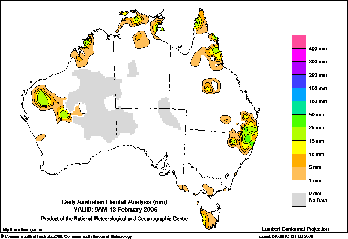
Todays highest rainfall totals for the 24 hours to 9am. It
includes the top 5 totals nationally followed by all reported falls of 50mm or more. |
Highest
and lowest recordings of hours of sunshine for the 24 hours to midnight. |
Highest wind
run totals in kilometres for the 24 hours to 9am (average speed in brackets).
All reported runs >
=25km/h are shown. |
Highest wind
gusts in km/h for the 24 hours to midnight followed by the hour in which it occurred.
All stations with gusts >
89km/h are shown. |
126.0 CLEARVIEW TM Brisbane/SE Coast QLD
124.0 GRANDCHESTER SYMES ST Brisbane/SE Coast QLD
122.5 NERANG GILSTON RD Brisbane/SE Coast QLD
120.0 CLEARVIEW ALERT Brisbane/SE Coast QLD
83.0 EBOR (PLEASANT VIEW) N Tablelands E NSW
WESTERN AUSTRALIA
Interior
53.4 WONGAWOL
QUEENSLAND
Brisbane/SE Coast
126.0 CLEARVIEW TM
124.0 GRANDCHESTER SYMES ST
122.5 NERANG GILSTON RD
120.0 CLEARVIEW ALERT
75.6 MAROON
69.0 KALBAR TM
66.2 GUANABA BIRDS RD
65.2 ROMANI TM
63.0 ROMANI ALERT
60.0 WOLFFDENE ALERT
60.0 ROSEVALE
57.0 HARRISVILLE TM
55.2 CANNON COVE TM
52.2 HARRISVILLE POST OFFICE
51.0 WONDAI POST OFFICE
50.0 OXENFORD (OBERON WAY)
Darling Downs E
62.4 QUEEN MARY FALLS
56.2 GIRRAWEEN NAT PARK
55.0 PRATTEN
53.5 ELLANGOWAN
NEW SOUTH WALES
N Tablelands W
64.2 GLEN INNES POST OFFICE
62.2 LEGUME (ACACIA PLATEAU (VERDANT HILLS))
58.2 GLEN INNES AIRPORT AWS
56.2 GLEN INNES AG RESEARCH STN
55.0 GLEN INNES (LYNDALE)
53.2 GLEN INNES (REDDESTONE (REDBANK))
52.4 ARMIDALE (TIVERTON)
N Tablelands E
83.0 EBOR (PLEASANT VIEW)
North Coast
51.0 THE CHANNON
MidNorth Coast N
78.2 COFFS HARBOUR MO
|
13.0 COBAR MO Upper Darling NSW
12.8 WOOMERA AERODROME NW Pastoral SA
12.8 WAGGA WAGGA AMO SW Slopes S NSW
12.7 ADELAIDE (KENT TOWN) Adelaide/Lofty SA
12.7 MILDURA AIRPORT Mallee N VIC
12.7 SCOTTSDALE (WEST MINSTONE ROAD) N Coast TAS
12.7 PERTH AIRPORT Lower West WA
12.7 ALBANY AIRPORT Lower West WA
.....
7.3 LAKE LEAKE (ELIZABETH RIVER) E Coast TAS
6.9 WEIPA AERO N Peninsula QLD
6.9 COFFS HARBOUR MO MidNorth Coast N NSW
6.7 HOBART AIRPORT Southeast TAS
0.8 STRATHGORDON VILLAGE W Coast TAS
|
1522 (63.4) MAATSUYKER ISLAND LIGHTHOUSE Southeast TAS
1133 (47.2) MOUNT WELLINGTON Southeast TAS
992 (41.3) CAPE GRIM BAPS N Coast TAS
976 (40.7) SCOTTS PEAK DAM W Coast TAS
929 (38.7) THREDBO AWS Snowy Mtns NSW
859 (35.8) MOUNT READ W Coast TAS
852 (35.5) GREEN CAPE AWS South Coast NSW
835 (34.8) CAPE LEEUWIN Lower West WA
832 (34.7) LOW HEAD N Coast TAS
796 (33.2) WILSONS PROMONTORY LIGHTHOUSE W Gippsland VIC
777 (32.4) FLINDERS ISLAND AIRPORT Flinders Is/Bass St TAS
758 (31.6) HOGAN ISLAND Islands ISL
750 (31.3) HARTZ MOUNTAIN (KEOGHS PIMPLE) Southeast TAS
740 (30.8) COLAC (MT GELLIBRAND) W Coast VIC
738 (30.8) MT HOTHAM Upper NE VIC
726 (30.3) CAPE OTWAY LIGHTHOUSE W Coast VIC
713 (29.7) KING ISLAND AIRPORT King Island TAS
711 (29.6) STRAHAN AERODROME W Coast TAS
698 (29.1) SWAN ISLAND E Coast TAS
693 (28.9) HAMILTON ISLAND AIRPORT Central Coast E QLD
682 (28.4) CAPE WILLOUGHBY Yorke Pen/Kanga Is SA
657 (27.4) PORT FAIRY AWS W Coast VIC
655 (27.3) EDDYSTONE POINT E Coast TAS
634 (26.4) NEPTUNE ISLAND W Agricultural SA
618 (25.8) LIAWENEE Central Plateau TAS
617 (25.7) CAPE BRUNY (CAPE BRUNY) Southeast TAS
612 (25.5) SYDNEY AIRPORT AMO Sydney--east NSW
|
117/19 CENTURY MINE Gulf Country QLD
109/00 MAATSUYKER ISLAND LIGHTHOUSE Southeast TAS
100/15 GUNNEDAH AIRPORT AWS NW Slopes S NSW
100/18 MOUNT WELLINGTON Southeast TAS
83/16 NARRABRI AIRPORT AWS NW Slopes N NSW
|
�