|
For notes on how to interpret
the data and quality control issues, see Daily Weather Summary Help.
**S** and **W** precede data flagged by the Bureau as suspicious or wrong
Data is as received at 03:55EST, 15/05/2012.
|
|
| |
Max
°
C |
+/- norm
°
C |
Min
°
C |
+/- norm
°
C |
Grass Min
°
C |
Rain to 9am mm |
Evaporation to 9am mm |
Sunshine hours |
Wind Run to 9am km (24-hour average km/h) |
Maximum Gust km/h / hour of occurrence |
| GERALDTON AIRPORT |
41.1 |
+8.6 |
19.7 |
+0.6 |
16.6 |
0.0 |
11.0 |
-- |
585 (24.4) |
46/08 |
| PERTH AIRPORT |
36.4 |
+4.6 |
18.4 |
+1.0 |
17.2 |
0.0 |
11.0 |
12.3 |
631 (26.3) |
61/00 |
| ALBANY AIRPORT |
24.9 |
0.0 |
14.8 |
+0.4 |
12.5 |
0.0 |
7.8 |
11.6 |
506 (21.1) |
54/14 |
| BUNBURY |
33.3 |
+3.5 |
15.9 |
+0.3 |
-- |
0.0 |
-- |
-- |
334 (13.9) |
39/01 |
| MANDURAH |
35.3 |
-- |
18.9 |
-- |
-- |
0.0 |
-- |
-- |
407 (17.0) |
41/00 |
| DARWIN AIRPORT |
32.1 |
+0.7 |
25.4 |
+0.7 |
24.4 |
0.2 |
5.0 |
10.8 |
319 (13.3) |
35/15 |
| ALICE SPRINGS AIRPORT |
35.3 |
+0.2 |
22.9 |
+2.1 |
22.2 |
0.0 |
16.8 |
11.9 |
423 (17.6) |
41/11 |
| WHYALLA AERO |
25.1 |
-4.5 |
19.5 |
+1.8 |
-- |
0.0 |
-- |
-- |
484 (20.2) |
46/17 |
| ADELAIDE (KENT TOWN) |
24.9 |
-4.4 |
16.3 |
-0.8 |
-- |
0.0 |
7.8 |
9.0 |
288 (12.0) |
39/12 |
| MOUNT GAMBIER AERO |
22.0 |
-3.1 |
15.0 |
+3.4 |
15.0 |
0.0 |
7.0 |
1.9 |
426 (17.8) |
41/12 |
| MOUNT ISA AERO |
35.8 |
+0.5 |
19.5 |
-3.9 |
18.5 |
0.0 |
5.0 |
11.5 |
165 ( 6.9) |
30/18 |
| CAIRNS AERO |
32.7 |
+1.5 |
24.8 |
+1.1 |
23.0 |
0.0 |
5.6 |
9.7 |
168 ( 7.0) |
28/12 |
| TOWNSVILLE AERO |
32.3 |
+1.2 |
25.7 |
+1.6 |
23.4 |
0.0 |
7.6 |
11.0 |
214 ( 8.9) |
28/12 |
| MACKAY M.O |
31.6 |
+2.0 |
25.0 |
+1.6 |
-- |
0.0 |
-- |
11.4 |
224 ( 9.3) |
24/14 |
| ROCKHAMPTON AERO |
33.1 |
+1.8 |
24.2 |
+2.1 |
22.6 |
0.0 |
6.2 |
-- |
196 ( 8.2) |
30/16 |
| BUNDABERG AERO |
33.1 |
+3.2 |
24.6 |
+3.2 |
-- |
0.0 |
1.4 |
-- |
222 ( 9.3) |
30/14 |
| NAMBOUR DPI |
35.0 |
+6.2 |
23.0 |
+3.3 |
-- |
0.0 |
-- |
-- |
-- |
-- |
| COOLANGATTA |
30.3 |
+2.1 |
22.6 |
+1.8 |
-- |
1.0 |
-- |
-- |
179 ( 7.5) |
48/14 |
| BRISBANE AERO |
30.7 |
+1.6 |
23.5 |
+2.4 |
23.0 |
0.6 |
7.6 |
5.0 |
350 (14.6) |
39/15 |
| TOOWOOMBA AIRPORT |
28.1 |
+0.7 |
19.9 |
+2.3 |
-- |
11.4 |
-- |
-- |
429 (17.9) |
37/12 |
| GUNNEDAH RESOURCE CENTRE |
32.2 |
+1.1 |
18.8 |
+0.2 |
11.5 |
0.0 |
4.5 |
-- |
102 ( 4.3) |
-- |
| COFFS HARBOUR MO |
27.6 |
+0.8 |
19.5 |
0.0 |
17.4 |
4.0 |
3.4 |
6.8 |
202 ( 8.4) |
24/16 |
| PORT MACQUARIE AIRPORT AWS |
27.7 |
+0.2 |
19.3 |
+1.0 |
-- |
0.0 |
-- |
-- |
-- |
-- |
| WILLIAMTOWN RAAF |
30.0 |
+2.5 |
20.0 |
+1.9 |
18.7 |
0.0 |
5.0 |
8.0 |
273 (11.4) |
35/14 |
| GOSFORD (NARARA RESEARCH STATION) AWS |
29.7 |
+2.6 |
19.5 |
+2.4 |
18.2 |
0.0 |
-- |
-- |
48 ( 2.0) |
21/15 |
| ORANGE AGRICULTURAL INSTITUTE |
28.4 |
+2.6 |
14.2 |
+1.1 |
7.2 |
0.0 |
6.2 |
9.9 |
-- |
-- |
| DUBBO AIRPORT AWS |
34.1 |
+2.1 |
15.4 |
-2.3 |
-- |
0.0 |
-- |
-- |
175 ( 7.3) |
28/12 |
| SYDNEY AIRPORT AMO |
27.4 |
+1.1 |
19.9 |
+0.9 |
17.0 |
0.0 |
7.8 |
9.6 |
355 (14.8) |
31/13 |
| RICHMOND RAAF |
32.4 |
+3.4 |
18.8 |
+1.2 |
-- |
5.0 |
-- |
-- |
171 ( 7.1) |
41/16 |
| BELLAMBI AWS |
24.9 |
+0.1 |
18.5 |
-0.6 |
-- |
5.8 |
-- |
-- |
259 (10.8) |
30/10 |
| CANBERRA AIRPORT |
30.3 |
+3.2 |
10.9 |
-2.2 |
7.1 |
0.0 |
8.6 |
3.3 |
250 (10.4) |
31/16 |
| WAGGA WAGGA AMO |
34.5 |
+3.6 |
16.5 |
+0.2 |
15.9 |
0.0 |
11.2 |
5.7 |
306 (12.8) |
48/14 |
| ALBURY AIRPORT AWS |
29.1 |
-2.2 |
18.7 |
+2.6 |
-- |
0.0 |
-- |
-- |
211 ( 8.8) |
41/10 |
| MILDURA AIRPORT |
30.2 |
-1.4 |
18.3 |
+1.9 |
18.2 |
0.0 |
12.4 |
7.6 |
364 (15.2) |
34/23 |
| TATURA INST SUSTAINABLE AG |
29.6 |
+0.1 |
19.1 |
+4.8 |
-- |
0.8 |
8.8 |
-- |
275 (11.5) |
50/05 |
| BENDIGO AIRPORT |
27.6 |
-1.8 |
17.6 |
+3.5 |
-- |
0.4 |
-- |
-- |
373 (15.5) |
�
52/01 |
| MELBOURNE REGIONAL OFFICE |
24.6 |
-1.2 |
18.0 |
+3.4 |
17.0 |
0.0 |
6.0 |
-- |
150 ( 6.3) |
44/19 |
| GEELONG AIRPORT |
23.1 |
-1.9 |
15.6 |
+2.2 |
-- |
0.0 |
-- |
-- |
333 (13.9) |
52/01 |
| BALLARAT AERODROME |
20.9 |
-4.1 |
13.2 |
+1.8 |
-- |
0.0 |
-- |
-- |
380 (15.8) |
41/16 |
| LAUNCESTON (TI TREE BEND) |
23.9 |
-0.5 |
16.6 |
+4.6 |
-- |
0.0 |
-- |
-- |
197 ( 8.2) |
37/12 |
| HOBART AIRPORT |
21.5 |
-0.8 |
13.6 |
+1.6 |
8.2 |
0.0 |
4.0 |
4.2 |
253 (10.5) |
31/13 |
| |
Max
°
C |
+/- norm
°
C |
Min
°
C |
+/- norm
°
C |
Grass Min
°
C |
Rain to 9am mm |
Evaporation to 9am mm |
Sunshine hours |
Wind Run to 9am km |
Maximum Gust km/h / hour of occurrence |
|
| Hottest |
| Highest maximum temperature> | Greatest variation above normal maximum |
Highest minimum temperature | Greatest variation above normal minimum |
41.2 SHARK BAY AIRPORT W Gascoyne WA
41.2 ENEABBA Central West WA
41.1 GERALDTON AIRPORT Central West WA
40.9 KALBARRI Central West WA
40.8 WALUNGURRU N Plateau NT
|
+8.8 : 38.5 LANCELIN Lower West WA
+8.6 : 41.1 GERALDTON AIRPORT Central West WA
+8.3 : 40.0 DENHAM W Gascoyne WA
+7.5 : 38.2 JURIEN BAY Lower West WA
+7.4 : 37.6 SWANBOURNE Lower West WA
|
28.2 NGAYAWILI N Rivers NT
28.0 TROUGHTON ISLAND N Kimberley WA
27.8 BALLERA GAS FIELD Far SW QLD
27.6 LOW ISLES LIGHTHOUSE N Coast--Barron QLD
27.5 MCCLUER ISLAND N Rivers NT
|
+7.1 : 21.8 KYABRAM DPI Lower North VIC
+7.0 : 22.2 ECHUCA AERODROME Lower North VIC
+6.5 : 22.6 DENILIQUIN AIRPORT AWS Riverina E NSW
+6.2 : 20.9 SHEPPARTON AIRPORT Upper North VIC
+5.6 : 22.0 HAY (MILLER STREET) Riverina W NSW
|
| Coldest |
| Lowest maximum temperature | Greatest variation below normal maximum |
Lowest minimum temperature | Greatest variation below normal minimum |
11.9 MT HOTHAM Upper NE VIC
13.0 GRAMPIANS (MOUNT WILLIAM) Wimmera S VIC
13.0 MOUNT WELLINGTON Southeast TAS
13.4 FALLS CREEK Upper NE VIC
14.3 THREDBO AWS Snowy Mtns NSW
|
-6.4 : 24.9 ROSEWORTHY AG COLLEGE Adelaide/Lofty SA
-6.2 : 19.9 MORTLAKE RACECOURSE W Coast VIC
-6.2 : 16.0 MOUNT LOFTY Adelaide/Lofty SA
-6.1 : 22.0 PRICE Yorke Pen/Kanga Is SA
-6.0 : 23.8 CLARE HIGH SCHOOL Lower North SA
|
2.5 PERISHER VALLEY SKI CENTRE Snowy Mtns NSW
4.9 LAKE ST CLAIR NATIONAL PARK Central Plateau TAS
5.0 BUTLERS GORGE Central Plateau TAS
5.5 THREDBO VILLAGE Snowy Mtns NSW
5.8 COOMA VISITORS CENTRE Goulburn/Monaro NSW
|
-6.4 : 17.0 URANDANGI Northwest QLD
**S** -6.2 : 11.0 PARKES AIRPORT AWS CW Slopes S NSW
-5.3 : 10.7 NORSEMAN AERO Goldfields WA
-5.0 : 17.0 WILUNA Interior WA
-4.8 : 9.4 SALMON GUMS RES.STN. Goldfields WA
|
|
Sunniest &
dullest |
Windiest |
Highest gusts |
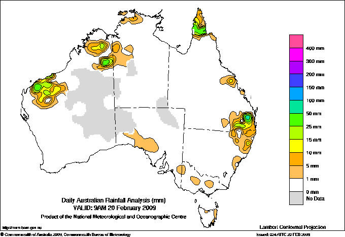
Todays highest rainfall totals for the 24 hours to 9am. It
includes the top 5 totals nationally followed by all reported falls of 50mm or more. |
Highest
and lowest recordings of hours of sunshine for the 24 hours to midnight. |
Highest wind
run totals in kilometres for the 24 hours to 9am (average speed in brackets).
All reported runs >
=25km/h are shown. |
Highest wind
gusts in km/h for the 24 hours to midnight followed by the hour in which it occurred.
All stations with gusts >
89km/h are shown. |
110.2 NANANGO WILLS ST Brisbane/SE Coast QLD
106.8 EMBREYS BRIDGE Brisbane/SE Coast QLD
80.0 YALLEEN W Pilbara WA
78.4 MT BINGA Brisbane/SE Coast QLD
78.0 YARRAMAN UPPER Brisbane/SE Coast QLD
WESTERN AUSTRALIA
W Pilbara
80.0 YALLEEN
QUEENSLAND
N Peninsula
69.2 PUNSAND BAY
50.0 COEN AIRPORT
Wide Bay/Burnett
53.4 DEEPBANK
Brisbane/SE Coast
110.2 NANANGO WILLS ST
106.8 EMBREYS BRIDGE
78.4 MT BINGA
78.0 YARRAMAN UPPER
69.0 HELIDON POST OFFICE
58.0 HELIDON TM
54.0 BUARABA
53.0 BLACKBUTT POST OFFICE
51.0 GRANDCHESTER SYMES ST
Darling Downs E
50.0 MAR-LEE
NEW SOUTH WALES
NW Slopes N
55.0 YETMAN (WARIALDA STREET)
North Coast
66.0 COPMANHURST (STOCKYARD CREEK)
|
12.7 LOXTON RESEARCH CENTRE Murray Valley SA
12.3 PERTH AIRPORT Lower West WA
12.3 WOOMERA AERODROME NW Pastoral SA
12.2 TENNANT CREEK AIRPORT N Plateau NT
11.9 ALICE SPRINGS AIRPORT N Plateau NT
.....
2.5 WEIPA AERO N Peninsula QLD
1.9 MOUNT GAMBIER AERO Lower SE SA
1.4 NORFOLK ISLAND AERO Islands ISL
0.0 BICHENO (COUNCIL DEPOT) E Coast TAS
**W** 0.0 WARWICK Darling Downs E QLD
|
911 (38.0) CAPE LEEUWIN Lower West WA
704 (29.3) HINDMARSH ISLAND AWS Adelaide/Lofty SA
638 (26.6) NORTH ISLAND Central West WA
633 (26.4) CAPE NATURALISTE Lower West WA
631 (26.3) NEPTUNE ISLAND W Agricultural SA
631 (26.3) PERTH AIRPORT Lower West WA
612 (25.5) CAPE OTWAY LIGHTHOUSE W Coast VIC
610 (25.4) ROTTNEST ISLAND Lower West WA
606 (25.3) GABO ISLAND LIGHTHOUSE E Gippsland VIC
|
72/14 GLEN INNES AIRPORT AWS N Tablelands W NSW
70/15 YAMBA PILOT STATION North Coast NSW
68/14 HOGAN ISLAND Islands ISL
67/10 WILSONS PROMONTORY LIGHTHOUSE W Gippsland VIC
65/17 INGLEWOOD FOREST Darling Downs E QLD
65/16 EVANS HEAD RAAF BOMBING RANGE AWS North Coast NSW
|
�