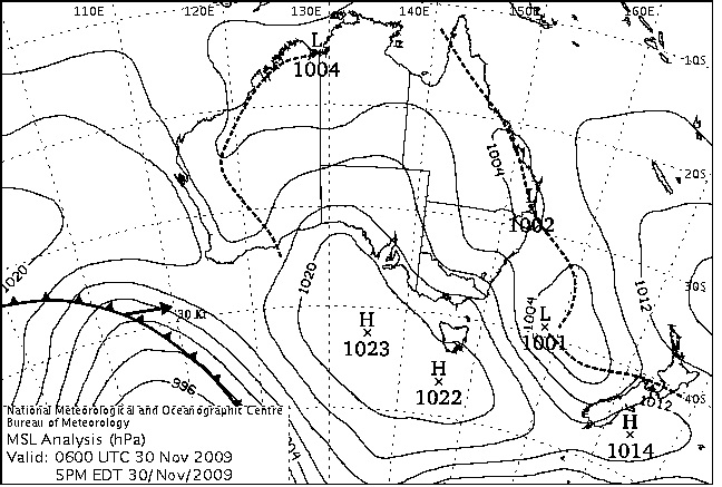
|
For notes on how to interpret
the data and quality control issues, see Daily Weather Summary Help.
**S** and **W** precede data flagged by the Bureau as suspicious or wrong
Data is as received at 08:44EST, 15/05/2012.
|
|
| |
Max
°
C |
+/- norm
°
C |
Min
°
C |
+/- norm
°
C |
Grass Min
°
C |
Rain to 9am mm |
Evaporation to 9am mm |
Sunshine hours |
Wind Run to 9am km (24-hour average km/h) |
Maximum Gust km/h / hour of occurrence |
| GERALDTON AIRPORT |
25.5 |
-1.6 |
14.6 |
+0.8 |
12.5 |
0.0 |
8.0 |
-- |
504 (21.0) |
39/12 |
| PERTH AIRPORT |
26.7 |
+0.9 |
9.4 |
-3.2 |
9.2 |
0.0 |
7.8 |
12.6 |
326 (13.6) |
37/13 |
| ALBANY AIRPORT |
21.5 |
+0.7 |
9.7 |
-1.1 |
5.5 |
0.0 |
6.2 |
11.7 |
265 (11.0) |
30/12 |
| BUNBURY |
23.3 |
-0.9 |
9.5 |
-2.5 |
-- |
0.0 |
-- |
-- |
333 (13.9) |
44/16 |
| MANDURAH |
24.2 |
-- |
15.4 |
-- |
-- |
0.0 |
-- |
-- |
458 (19.1) |
46/14 |
| DARWIN AIRPORT |
34.5 |
+1.2 |
25.5 |
+0.2 |
25.7 |
0.0 |
5.8 |
5.8 |
409 (17.0) |
39/15 |
| ALICE SPRINGS AIRPORT |
32.5 |
-1.1 |
15.4 |
-2.5 |
12.0 |
0.0 |
12.6 |
13.4 |
324 (13.5) |
43/11 |
| WHYALLA AERO |
21.9 |
-4.6 |
14.2 |
+0.3 |
-- |
2.4 |
9.8 |
-- |
581 (24.2) |
52/17 |
| ADELAIDE (KENT TOWN) |
22.4 |
-2.7 |
13.1 |
-0.9 |
-- |
0.6 |
13.6 |
10.4 |
333 (13.9) |
37/09 |
| MOUNT GAMBIER AERO |
20.6 |
+0.2 |
12.5 |
+4.1 |
11.4 |
0.4 |
2.6 |
9.5 |
570 (23.8) |
44/15 |
| MOUNT ISA AERO |
34.9 |
-1.5 |
21.7 |
+0.3 |
18.6 |
0.0 |
14.6 |
12.6 |
485 (20.2) |
50/16 |
| CAIRNS AERO |
30.7 |
+0.1 |
24.9 |
+2.6 |
22.8 |
0.0 |
5.6 |
9.6 |
246 (10.3) |
26/13 |
| TOWNSVILLE AERO |
34.3 |
+3.5 |
24.4 |
+1.5 |
21.8 |
0.6 |
7.2 |
12.5 |
327 (13.6) |
43/12 |
| MACKAY M.O |
34.0 |
+4.8 |
24.2 |
+2.5 |
-- |
0.0 |
-- |
11.3 |
482 (20.1) |
46/18 |
| ROCKHAMPTON AERO |
38.3 |
+7.1 |
24.1 |
+4.6 |
22.8 |
0.4 |
10.8 |
-- |
319 (13.3) |
52/14 |
| BUNDABERG AERO |
28.0 |
-0.3 |
21.2 |
+2.3 |
-- |
1.6 |
10.6 |
-- |
503 (21.0) |
-- |
| NAMBOUR DPI |
33.0 |
+5.0 |
20.0 |
+3.7 |
-- |
13.0 |
-- |
-- |
-- |
-- |
| COOLANGATTA |
29.7 |
+3.9 |
20.4 |
+2.2 |
-- |
0.0 |
-- |
-- |
452 (18.8) |
43/22 |
| BRISBANE AERO |
31.6 |
+4.8 |
21.4 |
+3.4 |
16.8 |
1.4 |
7.8 |
-- |
631 (26.3) |
52/14 |
| TOOWOOMBA AIRPORT |
31.8 |
+6.1 |
16.5 |
+2.0 |
-- |
0.0 |
-- |
-- |
447 (18.6) |
54/14 |
| GUNNEDAH RESOURCE CENTRE |
28.5 |
+0.2 |
15.2 |
+0.2 |
8.1 |
0.0 |
10.8 |
-- |
301 (12.5) |
-- |
| COFFS HARBOUR MO |
25.9 |
+1.0 |
16.9 |
+0.8 |
15.8 |
0.0 |
8.8 |
10.3 |
360 (15.0) |
50/19 |
| PORT MACQUARIE AIRPORT AWS |
25.7 |
+0.8 |
15.2 |
+0.2 |
-- |
0.0 |
-- |
-- |
-- |
-- |
| WILLIAMTOWN RAAF |
24.1 |
-1.3 |
14.3 |
0.0 |
11.1 |
0.0 |
14.4 |
5.5 |
517 (21.5) |
55/15 |
| GOSFORD (NARARA RESEARCH STATION) AWS |
23.4 |
-1.7 |
12.0 |
-1.1 |
-- |
0.0 |
-- |
-- |
97 ( 4.0) |
41/15 |
| ORANGE AGRICULTURAL INSTITUTE |
19.5 |
-1.6 |
9.4 |
+0.3 |
6.8 |
0.0 |
6.4 |
10.6 |
-- |
-- |
| DUBBO AIRPORT AWS |
27.6 |
-0.8 |
12.6 |
-1.0 |
-- |
0.0 |
-- |
-- |
466 (19.4) |
57/19 |
| SYDNEY AIRPORT AMO |
21.6 |
-2.4 |
18.2 |
+2.9 |
16.1 |
0.0 |
11.8 |
3.9 |
513 (21.4) |
70/13 |
| RICHMOND RAAF |
24.2 |
-2.4 |
13.7 |
-0.2 |
8.6 |
0.0 |
-- |
-- |
399 (16.6) |
50/10 |
| BELLAMBI AWS |
21.5 |
-0.6 |
15.7 |
+0.1 |
-- |
0.0 |
-- |
-- |
379 (15.8) |
74/15 |
| CANBERRA AIRPORT |
18.6 |
-4.1 |
11.7 |
+2.9 |
9.1 |
2.2 |
3.8 |
2.7 |
393 (16.4) |
43/12 |
| WAGGA WAGGA AMO |
24.2 |
-1.5 |
10.8 |
+0.1 |
8.4 |
4.8 |
4.8 |
6.9 |
305 (12.7) |
50/15 |
| ALBURY AIRPORT AWS |
23.9 |
-2.1 |
13.2 |
+1.6 |
-- |
2.4 |
-- |
-- |
208 ( 8.7) |
50/22 |
| MILDURA AIRPORT |
25.2 |
-2.2 |
12.8 |
+0.3 |
11.4 |
0.4 |
7.4 |
11.7 |
451 (18.8) |
50/17 |
| TATURA INST SUSTAINABLE AG |
23.9 |
-0.7 |
13.2 |
+3.1 |
-- |
11.83 |
16.4 |
-- |
478 (19.9) |
43/16 |
| BENDIGO AIRPORT |
22.0 |
-2.2 |
12.0 |
+2.5 |
-- |
1.4 |
-- |
-- |
382 (15.9) |
�
50/13 |
| MELBOURNE REGIONAL OFFICE |
20.8 |
-1.1 |
14.0 |
+2.8 |
13.2 |
10.6 |
4.4 |
-- |
-- |
-- |
| GEELONG AIRPORT |
19.4 |
-1.6 |
12.8 |
+3.2 |
-- |
17.2 |
-- |
-- |
469 (19.5) |
50/12 |
| BALLARAT AERODROME |
18.2 |
-1.4 |
10.3 |
+2.5 |
-- |
1.0 |
-- |
-- |
492 (20.5) |
48/10 |
| LAUNCESTON (TI TREE BEND) |
17.0 |
-3.4 |
10.4 |
+1.5 |
-- |
0.0 |
-- |
-- |
640 (26.7) |
50/09 |
| HOBART AIRPORT |
14.4 |
-4.6 |
10.1 |
+0.9 |
9.2 |
2.4 |
2.2 |
0.5 |
724 (30.2) |
48/23 |
| |
Max
°
C |
+/- norm
°
C |
Min
°
C |
+/- norm
°
C |
Grass Min
°
C |
Rain to 9am mm |
Evaporation to 9am mm |
Sunshine hours |
Wind Run to 9am km |
Maximum Gust km/h / hour of occurrence |
|
| Hottest |
| Highest maximum temperature> | Greatest variation above normal maximum |
Highest minimum temperature | Greatest variation above normal minimum |
45.0 FITZROY CROSSING AERO W Kimberley WA
44.9 WEST ROEBUCK W Kimberley WA
44.6 CURTIN AERO W Kimberley WA
44.5 DERBY AERO W Kimberley WA
44.5 ROEBOURNE E Pilbara WA
|
+11.4 : 40.4 KALGOORLIE-BOULDER AIRPORT Goldfields WA
+10.6 : 39.3 NORSEMAN AERO Goldfields WA
+10.6 : 36.8 SALMON GUMS RES.STN. Goldfields WA
+10.4 : 38.5 NORSEMAN Goldfields WA
|
30.0 NORTHERN ENDEAVOUR Islands ISL
29.3 BRADSHAW N Rivers NT
29.2 NGAYAWILI N Rivers NT
29.0 TROUGHTON ISLAND N Kimberley WA
29.0 POINT FAWCETT Islands ISL
29.0 HALLS CREEK AIRPORT E Kimberley WA
29.0 BLACK POINT N Rivers NT
29.0 PORT KEATS AERO N Rivers NT
29.0 CAPE DON N Rivers NT
|
+8.0 : 18.2 SALMON GUMS RES.STN. Goldfields WA
+7.5 : 19.6 NORSEMAN AERO Goldfields WA
+6.9 : 19.1 NORSEMAN Goldfields WA
+6.4 : 23.7 SAMUEL HILL AERO Central Coast E QLD
+5.7 : 19.8 KALGOORLIE-BOULDER AIRPORT Goldfields WA
|
| Coldest |
| Lowest maximum temperature | Greatest variation below normal maximum |
Lowest minimum temperature | Greatest variation below normal minimum |
3.8 MOUNT WELLINGTON Southeast TAS
4.6 MT HOTHAM Upper NE VIC
5.0 THREDBO AWS Snowy Mtns NSW
5.8 FALLS CREEK Upper NE VIC
6.2 MOUNT BULLER Upper NE VIC
|
-8.8 : 10.3 GELANTIPY E Gippsland VIC
-8.7 : 9.4 DINNER PLAIN (MOUNT HOTHAM AIRPORT) Upper NE VIC
-8.2 : 12.7 COMBIENBAR AWS E Gippsland VIC
-7.8 : 13.1 MT NOWA NOWA E Gippsland VIC
-7.6 : 13.3 BOMBALA AWS Goulburn/Monaro NSW
-7.6 : 12.2 MELTON MOWBRAY (NORTH STOCKMAN) Southeast TAS
|
-0.4 MOUNT WELLINGTON Southeast TAS
**S** 0.0 TIDBINBILLA NATURE RESERVE Goulburn/Monaro NSW
0.9 MOUNT READ W Coast TAS
1.3 THREDBO AWS Snowy Mtns NSW
1.3 MT HOTHAM Upper NE VIC
|
**S** -8.9 : 0.0 TIDBINBILLA NATURE RESERVE Goulburn/Monaro NSW
**S** -6.8 : 2.3 DUNNS HILL E Central VIC
-6.5 : 11.9 KULGERA N Plateau NT
-6.1 : 15.6 MOUNT ELIZABETH N Kimberley WA
-5.0 : 5.8 WITCHCLIFFE Lower West WA
|
|
Sunniest &
dullest |
Windiest |
Highest gusts |
Todays highest rainfall totals for the 24 hours to 9am. It
includes the top 5 totals nationally followed by all reported falls of 50mm or more. |
Highest
and lowest recordings of hours of sunshine for the 24 hours to midnight. |
Highest wind
run totals in kilometres for the 24 hours to 9am (average speed in brackets).
All reported runs >
=25km/h are shown. |
Highest wind
gusts in km/h for the 24 hours to midnight followed by the hour in which it occurred.
All stations with gusts >
89km/h are shown. |
72.0 MOUNT WELLINGTON W Gippsland VIC
68.2 REEVES KNOB W Gippsland VIC
64.2 BULLUMWAAL E Gippsland VIC
50.0 SANDSPIT RIVER (RINGROVE) E Coast TAS
49.8 WEST WATERHOUSE N Rivers NT
NORTHERN TERRITORY
N Rivers
49.8 WEST WATERHOUSE
VICTORIA
E Gippsland
64.2 BULLUMWAAL
W Gippsland
72.0 MOUNT WELLINGTON
68.2 REEVES KNOB
TASMANIA
E Coast
50.0 SANDSPIT RIVER (RINGROVE)
|
13.4 ALICE SPRINGS AIRPORT N Plateau NT
13.3 GILES METEOROLOGICAL OFFICE Interior WA
13.2 MOREE AERO NW Plains E NSW
12.8 INVERELL RESEARCH CENTRE N Tablelands W NSW
12.6 BROOME AIRPORT W Kimberley WA
12.6 PERTH AIRPORT Lower West WA
12.6 MOUNT ISA AERO Gulf Country QLD
.....
1.3 EAST SALE AIRPORT W Gippsland VIC
0.5 HOBART AIRPORT Southeast TAS
0.4 BICHENO (COUNCIL DEPOT) E Coast TAS
0.2 GROVE (COMPARISON) Southeast TAS
0.0 LAKE LEAKE (ELIZABETH RIVER) E Coast TAS
|
1326 (55.3) EDDYSTONE POINT E Coast TAS
**S** 1049 (43.7) HOGAN ISLAND Islands ISL
1017 (42.4) MOUNT WELLINGTON Southeast TAS
913 (38.0) SWAN ISLAND E Coast TAS
885 (36.9) HAMILTON ISLAND AIRPORT Central Coast E QLD
848 (35.3) CAPE WILLOUGHBY Yorke Pen/Kanga Is SA
826 (34.4) WILSONS PROMONTORY LIGHTHOUSE W Gippsland VIC
811 (33.8) CAPE MORETON LIGHTHOUSE Brisbane/SE Coast QLD
795 (33.1) LOW HEAD N Coast TAS
776 (32.3) RUNDLE ISLAND Wide Bay/Burnett QLD
750 (31.3) TASMAN ISLAND Southeast TAS
743 (31.0) GABO ISLAND LIGHTHOUSE E Gippsland VIC
738 (30.8) MOUNT HOTHAM Upper NE VIC
736 (30.7) ROTTNEST ISLAND Lower West WA
734 (30.6) NEPTUNE ISLAND W Agricultural SA
725 (30.2) CAPE NELSON LIGHTHOUSE W Coast VIC
724 (30.2) HOBART AIRPORT Southeast TAS
713 (29.7) DEVONPORT AIRPORT N Coast TAS
708 (29.5) HERON ISLAND RES STN Wide Bay/Burnett QLD
706 (29.4) CAPE JAFFA (THE LIMESTONE) Lower SE SA
698 (29.1) CARNARVON AIRPORT W Gascoyne WA
688 (28.7) GREEN CAPE AWS South Coast NSW
685 (28.5) LADY ELLIOT ISLAND Wide Bay/Burnett QLD
676 (28.2) CRESSY RESEARCH STATION N Coast TAS
671 (28.0) MOUNT READ W Coast TAS
667 (27.8) HOBART (ELLERSLIE ROAD) Southeast TAS
663 (27.6) BYRON BAY (CAPE BYRON AWS) North Coast NSW
655 (27.3) PORT FAIRY AWS W Coast VIC
655 (27.3) LIAWENEE Central Plateau TAS
653 (27.2) PARAWA (SECOND VALLEY FOREST AWS) Adelaide/Lofty SA
653 (27.2) STRAHAN AERODROME W Coast TAS
641 (26.7) MURRURUNDI GAP AWS Hunter Valley NSW
640 (26.7) HORSHAM AERODROME Wimmera S VIC
640 (26.7) LAUNCESTON (TI TREE BEND) N Coast TAS
631 (26.3) BRISBANE AERO Brisbane/SE Coast QLD
613 (25.5) CAPE NATURALISTE Lower West WA
613 (25.5) CAPE BRUNY (CAPE BRUNY) Southeast TAS
610 (25.4) MONTAGUE ISLAND LIGHTHOUSE South Coast NSW
608 (25.3) ROBE AIRFIELD Lower SE SA
607 (25.3) FRIENDLY BEACHES E Coast TAS
605 (25.2) COLAC (MOUNT GELLIBRAND) W Coast VIC
602 (25.1) STENHOUSE BAY Yorke Pen/Kanga Is SA
602 (25.1) HAMILTON AIRPORT W Coast VIC
600 (25.0) WOOMERA AERODROME NW Pastoral SA
|
131/12 DOUBLE ISLAND POINT LIGHTHOUSE Brisbane/SE Coast QLD
83/11 MARYBOROUGH Brisbane/SE Coast QLD
83/23 EDDYSTONE POINT E Coast TAS
78/14 MONTAGUE ISLAND LIGHTHOUSE South Coast NSW
76/17 ULLADULLA AWS South Coast NSW
76/19 MOUNT HOTHAM Upper NE VIC
76/22 FALLS CREEK Upper NE VIC
|
�