|
For notes on how to interpret
the data and quality control issues, see Daily Weather Summary Help.
**S** and **W** precede data flagged by the Bureau as suspicious or wrong
Data is as received at 11:24EST, 15/05/2012.
|
|
| |
Max
°
C |
+/- norm
°
C |
Min
°
C |
+/- norm
°
C |
Grass Min
°
C |
Rain to 9am mm |
Evaporation to 9am mm |
Sunshine hours |
Wind Run to 9am km (24-hour average km/h) |
Maximum Gust km/h / hour of occurrence |
| GERALDTON AIRPORT |
34.8 |
+5.3 |
20.4 |
+4.1 |
18.6 |
0.0 |
8.6 |
-- |
311 (13.0) |
39/15 |
| PERTH AIRPORT |
36.5 |
+7.6 |
19.4 |
+4.6 |
17.1 |
0.0 |
11.0 |
13.1 |
359 (15.0) |
35/23 |
| ALBANY AIRPORT |
20.6 |
-2.5 |
16.9 |
+4.5 |
16.5 |
0.0 |
7.6 |
0.0 |
507 (21.1) |
31/13 |
| BUNBURY |
35.9 |
+8.8 |
17.8 |
+4.5 |
-- |
0.0 |
-- |
-- |
288 (12.0) |
43/19 |
| MANDURAH |
32.4 |
-- |
21.1 |
-- |
-- |
2.8 |
-- |
-- |
236 ( 9.8) |
41/16 |
| DARWIN AIRPORT |
33.3 |
+0.7 |
24.3 |
-1.0 |
24.6 |
21.8 |
5.2 |
7.2 |
210 ( 8.8) |
31/15 |
| ALICE SPRINGS AIRPORT |
36.4 |
+1.0 |
19.9 |
-0.3 |
17.3 |
0.0 |
14.0 |
11.7 |
420 (17.5) |
39/08 |
| WHYALLA AERO |
30.1 |
+2.0 |
13.8 |
-2.0 |
-- |
0.0 |
9.2 |
-- |
415 (17.3) |
30/20 |
| ADELAIDE (KENT TOWN) |
29.8 |
+2.8 |
13.0 |
-2.5 |
-- |
0.0 |
-- |
11.5 |
203 ( 8.5) |
24/12 |
| MOUNT GAMBIER AERO |
22.2 |
-0.7 |
9.6 |
-0.3 |
7.2 |
0.0 |
4.0 |
12.2 |
305 (12.7) |
31/15 |
| MOUNT ISA AERO |
37.9 |
+0.7 |
22.9 |
-0.2 |
21.0 |
0.0 |
5.8 |
11.0 |
253 (10.5) |
34/18 |
| CAIRNS AERO |
30.7 |
-0.7 |
22.9 |
-0.5 |
20.5 |
0.0 |
5.8 |
7.1 |
220 ( 9.2) |
37/13 |
| TOWNSVILLE AERO |
33.0 |
+1.5 |
24.8 |
+0.7 |
22.2 |
0.0 |
9.6 |
11.9 |
358 (14.9) |
37/11 |
| MACKAY M.O |
33.0 |
+2.9 |
23.8 |
+0.9 |
-- |
0.0 |
-- |
8.6 |
243 (10.1) |
52/20 |
| ROCKHAMPTON AERO |
34.8 |
+2.7 |
21.6 |
+0.4 |
20.8 |
1.0 |
6.8 |
-- |
224 ( 9.3) |
44/12 |
| BUNDABERG AERO |
31.1 |
+1.7 |
21.9 |
+1.4 |
-- |
1.0 |
6.4 |
-- |
253 (10.5) |
39/18 |
| NAMBOUR DPI |
28.0 |
-1.2 |
20.0 |
+1.8 |
-- |
4.0 |
-- |
-- |
-- |
-- |
| COOLANGATTA |
27.6 |
+0.4 |
20.7 |
+0.8 |
-- |
4.4 |
-- |
-- |
229 ( 9.5) |
41/13 |
| BRISBANE AERO |
25.8 |
-2.5 |
21.4 |
+1.3 |
21.0 |
4.4 |
5.2 |
0.0 |
317 (13.2) |
31/14 |
| TOOWOOMBA AIRPORT |
26.2 |
-1.5 |
17.7 |
+1.0 |
-- |
8.4 |
-- |
-- |
303 (12.6) |
39/23 |
| GUNNEDAH RESOURCE CENTRE |
33.1 |
+2.1 |
18.6 |
+1.1 |
11.8 |
0.0 |
8.0 |
-- |
233 ( 9.7) |
-- |
| COFFS HARBOUR MO |
24.7 |
-1.6 |
21.3 |
+3.2 |
20.9 |
0.0 |
3.0 |
3.3 |
329 (13.7) |
44/03 |
| PORT MACQUARIE AIRPORT AWS |
26.0 |
-0.6 |
16.5 |
-0.2 |
-- |
0.0 |
-- |
-- |
-- |
-- |
| WILLIAMTOWN RAAF |
24.6 |
-2.6 |
16.8 |
+0.3 |
13.9 |
1.0 |
8.6 |
0.8 |
395 (16.5) |
37/15 |
| GOSFORD (NARARA RESEARCH STATION) AWS |
23.9 |
-3.0 |
17.5 |
+2.2 |
-- |
3.6 |
-- |
-- |
146 ( 6.1) |
24/23 |
| ORANGE AGRICULTURAL INSTITUTE |
26.5 |
+2.1 |
11.5 |
+0.2 |
5.2 |
0.0 |
6.2 |
9.8 |
-- |
-- |
| DUBBO AIRPORT AWS |
32.9 |
+1.4 |
17.7 |
+1.8 |
-- |
0.0 |
-- |
-- |
373 (15.5) |
46/07 |
| SYDNEY AIRPORT AMO |
24.0 |
-1.7 |
19.0 |
+1.5 |
17.7 |
0.0 |
10.2 |
0.0 |
623 (26.0) |
41/21 |
| RICHMOND RAAF |
24.6 |
-4.1 |
17.3 |
+1.3 |
16.8 |
0.2 |
-- |
-- |
307 (12.8) |
31/14 |
| BELLAMBI AWS |
23.0 |
-1.1 |
16.2 |
-1.3 |
-- |
0.8 |
-- |
-- |
443 (18.5) |
39/19 |
| CANBERRA AIRPORT |
27.9 |
+1.8 |
13.8 |
+2.4 |
13.6 |
0.0 |
10.8 |
7.9 |
395 (16.5) |
44/17 |
| WAGGA WAGGA AMO |
31.8 |
+2.4 |
13.5 |
-0.2 |
9.4 |
0.0 |
12.0 |
11.8 |
352 (14.7) |
35/15 |
| ALBURY AIRPORT AWS |
31.3 |
+1.9 |
12.0 |
-1.7 |
-- |
0.0 |
-- |
-- |
234 ( 9.8) |
31/12 |
| MILDURA AIRPORT |
31.1 |
+1.0 |
13.4 |
-1.4 |
12.0 |
0.0 |
10.6 |
11.5 |
338 (14.1) |
24/14 |
| TATURA INST SUSTAINABLE AG |
28.8 |
+1.4 |
10.4 |
-1.8 |
-- |
0.0 |
-- |
-- |
497 (20.7) |
31/23 |
| BENDIGO AIRPORT |
28.2 |
+1.2 |
8.9 |
-2.6 |
-- |
0.0 |
-- |
-- |
423 (17.6) |
�
35/19 |
| MELBOURNE REGIONAL OFFICE |
22.1 |
-2.1 |
14.7 |
+1.8 |
14.2 |
0.0 |
5.8 |
-- |
-- |
-- |
| GEELONG AIRPORT |
19.7 |
-3.2 |
10.4 |
-0.5 |
-- |
0.0 |
-- |
-- |
311 (13.0) |
31/16 |
| BALLARAT AERODROME |
23.1 |
+0.5 |
7.8 |
-1.6 |
-- |
0.2 |
-- |
-- |
450 (18.8) |
35/06 |
| LAUNCESTON (TI TREE BEND) |
19.9 |
-2.5 |
12.2 |
+1.6 |
-- |
0.0 |
-- |
-- |
187 ( 7.8) |
39/13 |
| HOBART AIRPORT |
18.6 |
-2.0 |
10.1 |
-0.6 |
6.9 |
0.0 |
3.2 |
9.5 |
439 (18.3) |
41/17 |
| |
Max
°
C |
+/- norm
°
C |
Min
°
C |
+/- norm
°
C |
Grass Min
°
C |
Rain to 9am mm |
Evaporation to 9am mm |
Sunshine hours |
Wind Run to 9am km |
Maximum Gust km/h / hour of occurrence |
|
| Hottest |
| Highest maximum temperature> | Greatest variation above normal maximum |
Highest minimum temperature | Greatest variation above normal minimum |
43.7 ROEBOURNE E Pilbara WA
43.2 ROEBOURNE AERO E Pilbara WA
42.7 MURCHISON W Gascoyne WA
42.4 EMU CREEK STATION W Gascoyne WA
42.4 PAYNES FIND E Gascoyne WA
|
+12.2 : 37.8 ESPERANCE AERO Lower West WA
+10.8 : 39.7 SALMON GUMS RES.STN. Goldfields WA
+9.9 : 40.9 NORSEMAN AERO Goldfields WA
+9.5 : 38.7 NEWDEGATE RES.STATION Cent Wheatbelt WA
+9.2 : 33.7 ESPERANCE Lower West WA
|
29.5 PARABURDOO AERO E Gascoyne WA
29.1 MARBLE BAR E Pilbara WA
28.9 WITTENOOM W Pilbara WA
28.5 PORT HEDLAND AIRPORT E Pilbara WA
28.5 ROEBOURNE E Pilbara WA
|
+8.9 : 22.6 NORSEMAN AERO Goldfields WA
+8.5 : 23.1 BARRABA POST OFFICE NW Slopes N NSW
+8.4 : 22.5 NORSEMAN Goldfields WA
+7.1 : 23.7 KALGOORLIE-BOULDER AIRPORT Goldfields WA
+6.7 : 24.9 PAYNES FIND E Gascoyne WA
|
| Coldest |
| Lowest maximum temperature | Greatest variation below normal maximum |
Lowest minimum temperature | Greatest variation below normal minimum |
10.6 MOUNT WELLINGTON Southeast TAS
11.7 MOUNT READ W Coast TAS
14.1 MAATSUYKER ISLAND LIGHTHOUSE Southeast TAS
14.4 MT HOTHAM Upper NE VIC
14.6 CAPE BRUNY LIGHTHOUSE Southeast TAS
|
-9.9 : 21.2 CASINO AIRPORT North Coast NSW
-9.7 : 27.0 MANDORA E Pilbara WA
-9.2 : 27.9 DERBY AERO W Kimberley WA
-9.0 : 18.0 TABULAM (MUIRNE) N Tablelands E NSW
-8.6 : 21.3 CASINO AIRPORT AWS North Coast NSW
|
-0.4 LIAWENEE Central Plateau TAS
0.1 MOUNT WELLINGTON Southeast TAS
0.8 LAKE ST CLAIR NATIONAL PARK Central Plateau TAS
1.0 BUTLERS GORGE Central Plateau TAS
1.0 WARRA W Coast TAS
|
-6.0 : 2.9 DOVER Southeast TAS
-5.8 : 3.8 SMITHTON AERODROME N Coast TAS
-5.5 : 9.6 NARRANDERA GOLF CLUB Riverina E NSW
-5.4 : 18.3 BIRDSVILLE AIRPORT Channel Country QLD
-5.4 : 6.2 HORSHAM (POLKEMMET) Wimmera S VIC
|
|
Sunniest &
dullest |
Windiest |
Highest gusts |
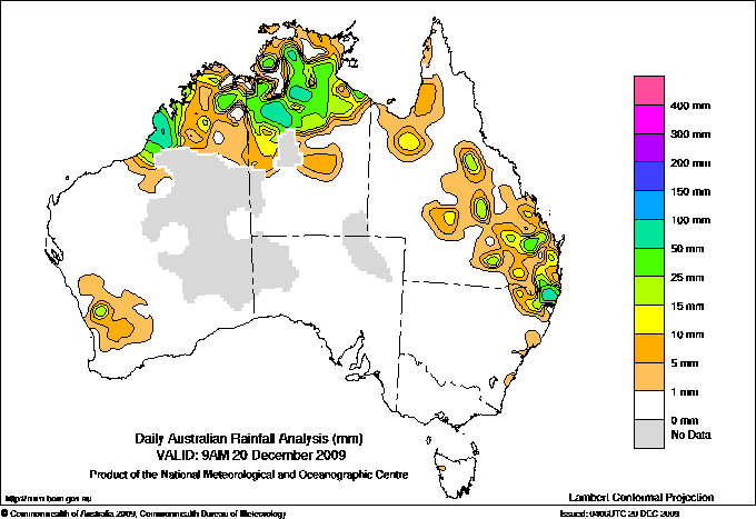
Todays highest rainfall totals for the 24 hours to 9am. It
includes the top 5 totals nationally followed by all reported falls of 50mm or more. |
Highest
and lowest recordings of hours of sunshine for the 24 hours to midnight. |
Highest wind
run totals in kilometres for the 24 hours to 9am (average speed in brackets).
All reported runs >
=25km/h are shown. |
Highest wind
gusts in km/h for the 24 hours to midnight followed by the hour in which it occurred.
All stations with gusts >
89km/h are shown. |
144.6 COUNTRY DOWNS W Kimberley WA
133.0 SUNDAY CREEK STATION N Rivers NT
120.0 ROEBUCK PLAINS W Kimberley WA
111.2 TABULAM (MUIRNE) N Tablelands E NSW
102.0 PIGEON HOLE N Rivers NT
WESTERN AUSTRALIA
W Kimberley
144.6 COUNTRY DOWNS
120.0 ROEBUCK PLAINS
88.2 WEST ROEBUCK
82.0 BEAGLE BAY
80.6 PORT SMITH
76.8 BROOME AIRPORT
63.2 BIDYADANGA
59.6 THANGOO
52.0 KIMBOLTON
NORTHERN TERRITORY
N Rivers
133.0 SUNDAY CREEK STATION
102.0 PIGEON HOLE
86.0 WAVE HILL
79.4 GILNOCKIE
77.0 VENN
70.9 MARY RIVER RANGERS
60.8 LAKEFIELD
60.0 CUTTA CUTTA
59.0 BENMARA
58.1 GIRRAWEEN
57.0 WEST ELSEY
54.0 BUNDA
QUEENSLAND
N Peninsula
55.2 SOUTHWELL STATION
Gulf Country
96.0 RUTLAND PLAINS STATION
57.6 NORMANTON AIRPORT
Upper Carpentaria
80.0 EVELEIGH STATION
Central Coast E
54.0 BALMORAL STATION
Central Highlands
68.0 BROADMERE
Wide Bay/Burnett
66.0 CAMBOON STATION
51.8 GLENWOOD
Darling Downs E
57.6 YANGAN POST OFFICE
NEW SOUTH WALES
N Tablelands E
111.2 TABULAM (MUIRNE)
98.0 MALLANGANEE (SANDILANDS ST)
85.0 TABULAM POST OFFICE
North Coast
92.2 CASINO AIRPORT
91.0 NEW ITALY (VINEYARD HAVEN)
89.0 CASINO AIRPORT AWS
71.0 MUMMULGUM (BINGEEBEEBRA)
67.0 WOOLNERS ARM
57.0 WIANGAREE POST OFFICE
55.0 CORAKI (UNION ST)
53.0 BRAYS CREEK (MISTY MOUNTAIN)
50.4 ROSEBANK (REPENTANCE CREEK)
|
13.7 CEDUNA AMO W Agricultural SA
13.5 LIAWENEE Central Plateau TAS
13.4 WOOMERA AERODROME NW Pastoral SA
13.1 PERTH AIRPORT Lower West WA
12.2 MOUNT GAMBIER AERO Lower SE SA
.....
0.0 BROOME AIRPORT W Kimberley WA
0.0 ALBANY AIRPORT Lower West WA
**W** 0.0 WARWICK Darling Downs E QLD
0.0 ALSTONVILLE TROPICAL FRUIT RESEARCH STAT North Coast NSW
0.0 SYDNEY AIRPORT AMO Sydney--east NSW
0.0 BRISBANE AERO Brisbane/SE Coast QLD
|
980 (40.8) BROOME AIRPORT W Kimberley WA
884 (36.8) CAPE LEEUWIN Lower West WA
844 (35.2) CAPE GRIM BAPS N Coast TAS
825 (34.4) GABO ISLAND LIGHTHOUSE E Gippsland VIC
817 (34.0) GREEN CAPE AWS South Coast NSW
793 (33.0) VARANUS ISLAND Islands ISL
791 (33.0) LOW HEAD N Coast TAS
765 (31.9) BARROW ISLAND AIRPORT W Pilbara WA
704 (29.3) THEVENARD ISLAND W Pilbara WA
698 (29.1) WEST ROEBUCK W Kimberley WA
667 (27.8) SWAN ISLAND E Coast TAS
649 (27.0) MONTAGUE ISLAND LIGHTHOUSE South Coast NSW
637 (26.5) NORAH HEAD AWS Hunter Valley NSW
630 (26.3) WILSONS PROMONTORY LIGHTHOUSE W Gippsland VIC
625 (26.0) MOUNT READ W Coast TAS
623 (26.0) SYDNEY AIRPORT AMO Sydney--east NSW
612 (25.5) LEARMONTH AIRPORT W Pilbara WA
609 (25.4) ONSLOW AIRPORT W Pilbara WA
608 (25.3) MOUNT WELLINGTON Southeast TAS
|
67/01 BROOME AIRPORT W Kimberley WA
67/22 HAMILTON ISLAND AIRPORT Central Coast E QLD
65/13 FITZROY CROSSING AERO W Kimberley WA
65/09 EVANS HEAD RAAF BOMBING RANGE AWS North Coast NSW
61/01 WEST ROEBUCK W Kimberley WA
61/18 ONSLOW AIRPORT W Pilbara WA
61/20 TELFER AERO Interior WA
61/11 BYRON BAY (CAPE BYRON AWS) North Coast NSW
|
�