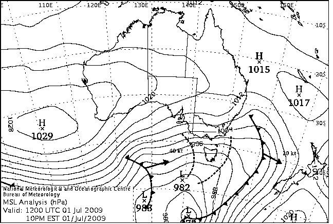
|
For notes on how to interpret
the data and quality control issues, see Daily Weather Summary Help.
**S** and **W** precede data flagged by the Bureau as suspicious or wrong
Data is as received at 04:36EST, 15/05/2012.
|
|
| |
Max
°
C |
+/- norm
°
C |
Min
°
C |
+/- norm
°
C |
Grass Min
°
C |
Rain to 9am mm |
Evaporation to 9am mm |
Sunshine hours |
Wind Run to 9am km (24-hour average km/h) |
Maximum Gust km/h / hour of occurrence |
| GERALDTON AIRPORT |
17.9 |
-1.6 |
12.2 |
+2.7 |
8.1 |
1.4 |
2.2 |
-- |
378 (15.8) |
46/15 |
| PERTH AIRPORT |
17.7 |
-0.2 |
8.9 |
+0.8 |
6.6 |
5.2 |
1.2 |
7.4 |
344 (14.3) |
34/12 |
| ALBANY AIRPORT |
14.8 |
-1.0 |
7.9 |
+0.4 |
6.6 |
12.4 |
1.4 |
6.5 |
448 (18.7) |
-- |
| BUNBURY |
17.2 |
0.0 |
6.2 |
-1.0 |
-- |
0.6 |
-- |
-- |
195 ( 8.1) |
31/11 |
| MANDURAH |
17.4 |
-- |
9.2 |
-- |
-- |
2.0 |
-- |
-- |
254 (10.6) |
34/14 |
| DARWIN AIRPORT |
34.0 |
+3.5 |
21.5 |
+2.3 |
20.5 |
0.0 |
4.4 |
9.8 |
252 (10.5) |
46/14 |
| ALICE SPRINGS AIRPORT |
23.0 |
+3.3 |
13.0 |
+9.0 |
10.1 |
0.0 |
8.0 |
10.3 |
446 (18.6) |
28/10 |
| WHYALLA AERO |
18.2 |
+1.3 |
8.7 |
+3.4 |
-- |
2.4 |
2.8 |
-- |
586 (24.4) |
46/15 |
| ADELAIDE (KENT TOWN) |
15.1 |
-0.2 |
10.7 |
+3.2 |
-- |
16.6 |
2.4 |
1.2 |
534 (22.3) |
55/00 |
| MOUNT GAMBIER AERO |
14.5 |
+1.4 |
7.9 |
+2.7 |
6.6 |
35.4 |
0.8 |
6.4 |
534 (22.3) |
76/11 |
| MOUNT ISA AERO |
33.1 |
+8.4 |
9.9 |
+1.3 |
8.5 |
0.0 |
6.2 |
10.5 |
177 ( 7.4) |
31/14 |
| CAIRNS AERO |
27.8 |
+2.1 |
19.2 |
+2.2 |
16.0 |
0.0 |
5.2 |
8.9 |
234 ( 9.8) |
28/15 |
| TOWNSVILLE AERO |
26.9 |
+1.8 |
16.4 |
+2.8 |
15.1 |
0.0 |
6.2 |
10.7 |
322 (13.4) |
30/13 |
| MACKAY M.O |
25.9 |
+4.6 |
13.7 |
+0.9 |
-- |
0.0 |
-- |
10.2 |
256 (10.7) |
28/15 |
| ROCKHAMPTON AERO |
28.2 |
+5.1 |
7.9 |
-1.6 |
6.3 |
0.0 |
3.0 |
-- |
125 ( 5.2) |
26/16 |
| BUNDABERG AERO |
24.0 |
+2.0 |
10.3 |
+0.2 |
-- |
0.0 |
0.6 |
-- |
137 ( 5.7) |
34/15 |
| NAMBOUR DPI |
25.0 |
+3.9 |
12.0 |
+4.3 |
-- |
0.0 |
-- |
-- |
-- |
-- |
| COOLANGATTA |
22.5 |
+2.0 |
12.8 |
+2.9 |
-- |
0.0 |
-- |
-- |
219 ( 9.1) |
43/11 |
| BRISBANE AERO |
22.0 |
+1.1 |
10.3 |
+1.5 |
6.4 |
0.0 |
1.8 |
8.0 |
212 ( 8.8) |
34/14 |
| TOOWOOMBA AIRPORT |
22.2 |
+5.6 |
10.4 |
+4.1 |
-- |
-- |
-- |
-- |
250 (10.4) |
-- |
| GUNNEDAH RESOURCE CENTRE |
21.3 |
+5.2 |
10.6 |
+5.9 |
5.2 |
0.0 |
2.4 |
-- |
195 ( 8.1) |
-- |
| COFFS HARBOUR MO |
23.9 |
+5.2 |
10.5 |
+3.0 |
7.2 |
0.0 |
1.6 |
9.1 |
311 (13.0) |
41/10 |
| PORT MACQUARIE AIRPORT AWS |
25.3 |
+6.6 |
5.7 |
-0.6 |
-- |
0.0 |
-- |
-- |
-- |
-- |
| WILLIAMTOWN RAAF |
21.9 |
+4.9 |
5.5 |
-0.8 |
4.0 |
0.0 |
1.4 |
8.3 |
232 ( 9.7) |
63/12 |
| GOSFORD (NARARA RESEARCH STATION) AWS |
22.2 |
+4.7 |
8.3 |
+3.7 |
4.8 |
0.0 |
-- |
-- |
63 ( 2.6) |
28/14 |
| ORANGE AGRICULTURAL INSTITUTE |
11.5 |
+2.2 |
4.7 |
+3.3 |
2.8 |
1.2 |
1.0 |
6.2 |
-- |
-- |
| DUBBO AIRPORT AWS |
18.1 |
+2.9 |
9.5 |
+6.5 |
-- |
0.0 |
-- |
-- |
535 (22.3) |
44/13 |
| SYDNEY AIRPORT AMO |
22.0 |
+5.0 |
13.4 |
+6.3 |
9.2 |
0.0 |
4.0 |
8.6 |
565 (23.5) |
54/15 |
| RICHMOND RAAF |
21.2 |
+3.8 |
13.7 |
+10.2 |
9.0 |
0.0 |
-- |
-- |
323 (13.5) |
44/14 |
| BELLAMBI AWS |
20.1 |
+3.3 |
13.3 |
+3.3 |
-- |
0.0 |
-- |
-- |
501 (20.9) |
63/13 |
| CANBERRA AIRPORT |
12.9 |
+1.6 |
7.5 |
+7.6 |
5.8 |
9.8 |
3.4 |
8.6 |
626 (26.1) |
70/14 |
| WAGGA WAGGA AMO |
14.3 |
+1.6 |
6.5 |
+3.8 |
2.0 |
5.4 |
1.6 |
5.0 |
310 (12.9) |
44/11 |
| ALBURY AIRPORT AWS |
13.3 |
+0.3 |
8.3 |
+5.1 |
-- |
8.4 |
-- |
-- |
333 (13.9) |
52/19 |
| MILDURA AIRPORT |
17.0 |
+1.7 |
9.3 |
+5.0 |
6.8 |
2.0 |
3.8 |
6.6 |
594 (24.8) |
50/12 |
| TATURA INST SUSTAINABLE AG |
14.4 |
+1.4 |
6.1 |
+3.2 |
-- |
3.6 |
2.0 |
-- |
493 (20.5) |
50/12 |
| BENDIGO AIRPORT |
13.1 |
+0.6 |
7.4 |
+5.0 |
-- |
6.6 |
-- |
-- |
549 (22.9) |
�
57/13 |
| MELBOURNE REGIONAL OFFICE |
15.6 |
+2.2 |
10.9 |
+4.9 |
7.8 |
2.6 |
2.8 |
-- |
267 (11.1) |
41/13 |
| GROVEDALE (GEELONG AIRPORT) |
14.8 |
+1.0 |
10.3 |
+4.9 |
-- |
2.2 |
-- |
-- |
772 (32.2) |
87/10 |
| BALLARAT AERODROME |
11.2 |
+1.2 |
6.1 |
+2.9 |
-- |
7.0 |
-- |
-- |
799 (33.3) |
68/14 |
| LAUNCESTON (TI TREE BEND) |
11.2 |
-1.4 |
8.8 |
+6.6 |
-- |
11.5 |
-- |
-- |
518 (21.6) |
50/12 |
| HOBART AIRPORT |
12.3 |
-0.1 |
8.9 |
+4.8 |
5.1 |
1.2 |
1.0 |
-- |
574 (23.9) |
52/00 |
| |
Max
°
C |
+/- norm
°
C |
Min
°
C |
+/- norm
°
C |
Grass Min
°
C |
Rain to 9am mm |
Evaporation to 9am mm |
Sunshine hours |
Wind Run to 9am km |
Maximum Gust km/h / hour of occurrence |
|
| Hottest |
| Highest maximum temperature> | Greatest variation above normal maximum |
Highest minimum temperature | Greatest variation above normal minimum |
36.9 WYNDHAM AERO N Kimberley WA
36.6 BRADSHAW N Rivers NT
36.1 JABIRU AIRPORT N Rivers NT
36.1 MIDDLE POINT AWS N Rivers NT
36.0 WYNDHAM N Kimberley WA
36.0 KIMBERLEY RES.STATION E Kimberley WA
36.0 DOUGLAS RIVER N Rivers NT
|
+10.1 : 33.6 LONGREACH AERO Central West QLD
+9.5 : 29.5 INJUNE POST OFFICE Maranoa QLD
+9.3 : 31.9 BARCALDINE POST OFFICE Central West QLD
+9.3 : 31.9 ISISFORD POST OFFICE Central West QLD
|
27.0 NORTHERN ENDEAVOUR Islands ISL
24.8 COCOS ISLAND AIRPORT Islands ISL
24.2 COCONUT ISLAND N Peninsula QLD
24.1 HORN ISLAND N Peninsula QLD
24.1 CHRISTMAS ISLAND AERO Islands ISL
|
+11.8 : 17.0 JERVOIS N Plateau NT
+10.2 : 13.7 RICHMOND RAAF Sydney--west NSW
+9.8 : 15.5 CUNNAMULLA POST OFFICE Warrego QLD
+9.7 : 11.7 MURRURUNDI POST OFFICE Hunter Valley NSW
+9.6 : 14.3 SCONE SCS Hunter Valley NSW
|
| Coldest |
| Lowest maximum temperature | Greatest variation below normal maximum |
Lowest minimum temperature | Greatest variation below normal minimum |
-1.3 MOUNT HOTHAM Upper NE VIC
-1.1 THREDBO AWS Snowy Mtns NSW
-0.4 FALLS CREEK Upper NE VIC
0.0 CHARLOTTE PASS (KOSCIUSKO CHALET) Snowy Mtns NSW
0.0 MOUNT BULLER Upper NE VIC
0.0 MOUNT GININI AWS Goulburn/Monaro NSW
|
-7.4 : 17.4 PARABURDOO AERO E Gascoyne WA
-6.1 : 16.9 TOM PRICE W Pilbara WA
-6.1 : 19.3 EMU CREEK STATION W Gascoyne WA
-5.8 : 17.1 GASCOYNE JUNCTION W Gascoyne WA
-5.3 : 17.7 NEWMAN AERO E Gascoyne WA
|
-3.2 CHARLOTTE PASS (KOSCIUSKO CHALET) Snowy Mtns NSW
-2.0 THREDBO AWS Snowy Mtns NSW
-1.9 MOUNT HOTHAM Upper NE VIC
-1.1 FALLS CREEK Upper NE VIC
-1.0 PERISHER VALLEY SKI CENTRE Snowy Mtns NSW
|
-3.7 : 3.0 RAVENSTHORPE Cent Wheatbelt WA
-3.7 : 12.9 LADY ELLIOT ISLAND Wide Bay/Burnett QLD
**S** -3.6 : 2.5 CRANBOURNE BOTANIC GARDENS E Central VIC
-2.8 : 1.4 NORSEMAN AERO Goldfields WA
-2.7 : 2.0 HYDEN Cent Wheatbelt WA
|
|
Sunniest &
dullest |
Windiest |
Highest gusts |
Todays highest rainfall totals for the 24 hours to 9am. It
includes the top 5 totals nationally followed by all reported falls of 50mm or more. |
Highest
and lowest recordings of hours of sunshine for the 24 hours to midnight. |
Highest wind
run totals in kilometres for the 24 hours to 9am (average speed in brackets).
All reported runs >
=25km/h are shown. |
Highest wind
gusts in km/h for the 24 hours to midnight followed by the hour in which it occurred.
All stations with gusts >
89km/h are shown. |
91.6 THREDBO VILLAGE Snowy Mtns NSW
77.0 FALLS CREEK (ROCKY VALLEY) Upper NE VIC
56.5 PERISHER VALLEY SKI CENTRE Snowy Mtns NSW
55.4 THREDBO AWS Snowy Mtns NSW
51.6 UPPER ESK (SOUTH ESK RIVER) E Coast TAS
NEW SOUTH WALES
Snowy Mtns
91.6 THREDBO VILLAGE
56.5 PERISHER VALLEY SKI CENTRE
55.4 THREDBO AWS
VICTORIA
Upper NE
77.0 FALLS CREEK (ROCKY VALLEY)
TASMANIA
E Coast
51.6 UPPER ESK (SOUTH ESK RIVER)
|
10.7 TOWNSVILLE AERO N Coast--Herbert QLD
10.5 MOUNT ISA AERO Gulf Country QLD
10.4 TENNANT CREEK AIRPORT N Plateau NT
10.3 GOVE AIRPORT N Rivers NT
10.3 ALICE SPRINGS AIRPORT N Plateau NT
10.3 RABBIT FLAT N Plateau NT
.....
1.2 ADELAIDE (KENT TOWN) Adelaide/Lofty SA
0.5 LAKE EILDON N Central VIC
0.2 LAKE LEAKE (ELIZABETH RIVER) E Coast TAS
0.1 STRATHGORDON VILLAGE W Coast TAS
0.0 SCOTTSDALE (WEST MINSTONE ROAD) N Coast TAS
|
1469 (61.2) NEPTUNE ISLAND W Agricultural SA
1458 (60.8) MOUNT WELLINGTON Southeast TAS
1344 (56.0) HOGAN ISLAND Islands ISL
1294 (53.9) MOUNT BULLER Upper NE VIC
1284 (53.5) FALLS CREEK Upper NE VIC
1264 (52.7) MOUNT READ W Coast TAS
1216 (50.7) CAPE GRIM BAPS N Coast TAS
1213 (50.5) COLAC (MOUNT GELLIBRAND) W Coast VIC
1195 (49.8) MOUNT HOTHAM Upper NE VIC
1135 (47.3) CAPE BORDA Yorke Pen/Kanga Is SA
1120 (46.7) LOW HEAD N Coast TAS
1107 (46.1) TASMAN ISLAND Southeast TAS
1055 (44.0) THREDBO AWS Snowy Mtns NSW
1053 (43.9) KING ISLAND AIRPORT King Island TAS
1040 (43.3) EDDYSTONE POINT E Coast TAS
1030 (42.9) SWAN ISLAND E Coast TAS
1007 (42.0) MINLATON AERO Yorke Pen/Kanga Is SA
975 (40.6) AIREYS INLET W Coast VIC
948 (39.5) WALLAN (KILMORE GAP) N Central VIC
941 (39.2) COULTA (COLES POINT) W Agricultural SA
930 (38.8) MAATSUYKER ISLAND LIGHTHOUSE Southeast TAS
914 (38.1) FLINDERS ISLAND AIRPORT Flinders Is/Bass St TAS
896 (37.3) CAPE LEEUWIN Lower West WA
891 (37.1) DEVONPORT AIRPORT N Coast TAS
868 (36.2) MOUNT CRAWFORD FIRE TOWER Adelaide/Lofty SA
867 (36.1) FERNY CREEK (DUNNS HILL) E Central VIC
861 (35.9) SCOTTS PEAK DAM W Coast TAS
846 (35.3) CAPE JAFFA (THE LIMESTONE) Lower SE SA
840 (35.0) ADELAIDE AIRPORT Adelaide/Lofty SA
835 (34.8) ROSEWORTHY AWS Adelaide/Lofty SA
835 (34.8) HINDMARSH ISLAND AWS Adelaide/Lofty SA
828 (34.5) MELBOURNE AIRPORT E Central VIC
826 (34.4) STENHOUSE BAY Yorke Pen/Kanga Is SA
826 (34.4) CAPE OTWAY LIGHTHOUSE W Coast VIC
818 (34.1) SNOWTOWN (RAYVILLE PARK) Lower North SA
815 (34.0) HORSHAM AERODROME Wimmera S VIC
812 (33.8) RHYLL E Central VIC
809 (33.7) STRATHALBYN RACECOURSE Murray Valley SA
804 (33.5) CLEVE AERODROME W Agricultural SA
799 (33.3) BALLARAT AERODROME Western Plains VIC
798 (33.3) MURRURUNDI GAP AWS Hunter Valley NSW
797 (33.2) CAPE WILLOUGHBY Yorke Pen/Kanga Is SA
792 (33.0) MONTAGUE ISLAND LIGHTHOUSE South Coast NSW
772 (32.2) EDITHBURGH Yorke Pen/Kanga Is SA
772 (32.2) GROVEDALE (GEELONG AIRPORT) W Central VIC
765 (31.9) HAMILTON AIRPORT W Coast VIC
764 (31.8) NORTH SHIELDS (PORT LINCOLN AWS) W Agricultural SA
758 (31.6) WUDINNA AERO W Agricultural SA
758 (31.6) SWAN HILL AERODROME Mallee S VIC
755 (31.5) CAPE NELSON LIGHTHOUSE W Coast VIC
753 (31.4) YUNTA AIRSTRIP Northeast SA
750 (31.3) NHILL AERODROME Wimmera N VIC
744 (31.0) CABRAMURRA SMHEA AWS SW Slopes S NSW
740 (30.8) NOARLUNGA Adelaide/Lofty SA
740 (30.8) TUNNACK FIRE STATION Southeast TAS
740 (30.8) STRAHAN AERODROME W Coast TAS
736 (30.7) LIAWENEE Central Plateau TAS
730 (30.4) LUNCHEON HILL (FORESTRY) N Coast TAS
728 (30.3) MOORABBIN AIRPORT E Central VIC
726 (30.3) GOULBURN AIRPORT AWS Goulburn/Monaro NSW
721 (30.0) PARAWA (SECOND VALLEY FOREST AWS) Adelaide/Lofty SA
720 (30.0) BOMBALA AWS Goulburn/Monaro NSW
712 (29.7) KEITH (MUNKORA) Mallee/Upper SE SA
711 (29.6) CAPE NATURALISTE Lower West WA
710 (29.6) CEDUNA AMO W Agricultural SA
708 (29.5) WALPEUP RESEARCH Mallee N VIC
707 (29.5) AVALON AIRPORT W Central VIC
704 (29.3) WOOMERA AERODROME NW Pastoral SA
698 (29.1) WARRNAMBOOL AIRPORT NDB W Coast VIC
693 (28.9) ESPERANCE AERO Lower West WA
688 (28.7) MORTLAKE RACECOURSE W Coast VIC
684 (28.5) MOUNT BOYCE AWS C Tablelands S NSW
682 (28.4) WILSONS PROMONTORY LIGHTHOUSE W Gippsland VIC
678 (28.3) LONGERENONG Wimmera S VIC
676 (28.2) ROTTNEST ISLAND Lower West WA
676 (28.2) ROBE AIRFIELD Lower SE SA
674 (28.1) SMITHTON AERODROME N Coast TAS
673 (28.0) KUITPO FOREST RESERVE Adelaide/Lofty SA
671 (28.0) COOBER PEDY AIRPORT NW Pastoral SA
671 (28.0) ESSENDON AIRPORT E Central VIC
668 (27.8) HARTZ MOUNTAIN (KEOGHS PIMPLE) Southeast TAS
664 (27.7) EDINBURGH RAAF Adelaide/Lofty SA
662 (27.6) EILDON FIRE TOWER N Central VIC
659 (27.5) SHEOAKS W Central VIC
655 (27.3) ESPERANCE Lower West WA
648 (27.0) MOSS VALE AWS Illawarra NSW
645 (26.9) NULLARBOR W Agricultural SA
642 (26.8) CAPE BRUNY (CAPE BRUNY) Southeast TAS
641 (26.7) RENMARK AERO Murray Valley SA
635 (26.5) LEIGH CREEK AIRPORT NE Pastoral SA
630 (26.3) GELANTIPY E Gippsland VIC
629 (26.2) FORREST Eucla WA
626 (26.1) CANBERRA AIRPORT Goulburn/Monaro NSW
625 (26.0) BRAIDWOOD RACECOURSE AWS South Coast NSW
619 (25.8) NARACOORTE AERODROME Lower SE SA
618 (25.8) CAMPANIA (KINCORA) Southeast TAS
612 (25.5) LAVERTON RAAF W Central VIC
606 (25.3) CRESSY RESEARCH STATION N Coast TAS
604 (25.2) GREEN CAPE AWS South Coast NSW
602 (25.1) TIBOOBURRA AIRPORT Far Northwest NSW
|
135/18 HOGAN ISLAND Islands ISL
117/18 WILSONS PROMONTORY LIGHTHOUSE W Gippsland VIC
113/01 MOUNT WELLINGTON Southeast TAS
107/01 MAATSUYKER ISLAND LIGHTHOUSE Southeast TAS
104/11 AIREYS INLET W Coast VIC
102/07 CAPE GRIM BAPS N Coast TAS
98/10 PORTLAND (CASHMORE AIRPORT) W Coast VIC
98/13 CAPE NELSON LIGHTHOUSE W Coast VIC
98/10 FALLS CREEK Upper NE VIC
94/04 NEPTUNE ISLAND W Agricultural SA
94/14 COLAC (MOUNT GELLIBRAND) W Coast VIC
94/02 SCOTTS PEAK DAM W Coast TAS
93/10 MOUNT BULLER Upper NE VIC
93/00 FLINDERS ISLAND AIRPORT Flinders Is/Bass St TAS
91/09 NARACOORTE AERODROME Lower SE SA
91/12 SWAN ISLAND E Coast TAS
91/12 KING ISLAND AIRPORT King Island TAS
|
�