Tuesday 27 OCT 2009
 

Home page

DWS ARCHIVE
2024 2023 2022 2021 2020 2019 2018 2017 2016 2015 2014 2013 2012 2011 2010 2009 2008 2007 2006 2005 2004 2003
Before 2003

About the DWS


2009

Dec

M Tu W Th F Sa Su
  01 02 03 04 05 06
07 08 09 10 11 12 13
14 15 16 17 18 19 20
21 22 23 24 25 26 27
28 29 30 31      

Nov

M Tu W Th F Sa Su
            01
02 03 04 05 06 07 08
09 10 11 12 13 14 15
16 17 18 19 20 21 22
23 24 25 26 27 28 29
30            

Oct

M Tu W Th F Sa Su
      01 02 03 04
05 06 07 08 09 10 11
12 13 14 15 16 17 18
19 20 21 22 23 24 25
26 27 28 29 30 31  

Sept

M Tu W Th F Sa Su
  01 02 03 04 05 06
07 08 09 10 11 12 13
14 15 16 17 18 19 20
21 22 23 24 25 26 27
28 29 30        

Aug

M Tu W Th F Sa Su
          01 02
03 04 05 06 07 08 09
10 11 12 13 14 15 16
17 18 19 20 21 22 23
24 25 26 27 28 29 30
31            

Jul

M Tu W Th F Sa Su
    01 02 03 04 05
06 07 08 09 10 11 12
13 14 15 16 17 18 19
20 21 22 23 24 25 26
27 28 29 30 31    

Jun

M Tu W Th F Sa Su
01 02 03 04 05 06 07
08 09 10 11 12 13 14
15 16 17 18 19 20 21
22 23 24 25 26 27 28
29 30          

May

M Tu W Th F Sa Su
        01 02 03
04 05 06 07 08 09 10
11 12 13 14 15 16 17
18 19 20 21 22 23 24
25 26 27 28 29 30 31

Apr

M Tu W Th F Sa Su
    01 02 03 04 05
06 07 08 09 10 11 12
13 14 15 16 17 18 19
20 21 22 23 24 25 26
27 28 29 30    

Mar

M Tu W Th F Sa Su
            01
02 03 04 05 06 07 08
09 10 11 12 13 14 15
16 17 18 19 20 21 22
23 24 25 26 27 28 29
30 31          

Feb

M Tu W Th F Sa Su
            01
02 03 04 05 06 07 08
09 10 11 12 13 14 15
16 17 18 19 20 21 22
23 24 25 26 27 28  

Jan

M Tu W Th F Sa Su
      01 02 03 04
05 06 07 08 09 10 11
12 13 14 15 16 17 18
19 20 21 22 23 24 25
26 27 28 29 30 31  

Monthly summaries:
from BoM

Find a place:
Google Maps |
Aust Gazetteer|
Geonames

Weather terms:
WeatherZone | BoM |
American Met Soc | NOAA | uk.sci.weather | India Meteorological Department

National Daily Weather Summary

Records set | Charts | Cities | Hottest | Coldest | Rain, sun & wind | Downpours & gales
State extremes | Noteworthy weather | Capital Cities | Regional Cities | Alpine Stations
Charts and data courtesy Bureau of Meteorology. MTSAT-1R operated by JMA
Noteworthy weather today
significant newsworthy major

NSW: Mid North Coast floods follow record rain

River height graphs for the Orara River at Glenreagh (above) and the Bellinger River at Thora (below). BoM

The torrential rain reported yesterday on the Mid North Coast continued overnight. As the surface trough responsible for the rain weakened today, rain eased off during the mid to late morning in the Bellinger and Orara catchments and later in the afternoon in the Kalang and Nambucca catchments. Floodwaters receded on Wednesday 28th. It is the fourth time this year that flooding has affected the Mid North Coast, and the State Emergency Services (SES) estimates that around 1500 residents were isolated by floodwaters.

On 29 October, the NSW State Government declared the Nambucca and Bellingen Shires disaster areas. The disaster declaration provides a range of assistance for residents, councils and business owners who have suffered property damage. Councils in particular have suffered damage to infrastructure, especially roads, bridges, causeways, culverts and water bores.

Early estimates by Nambucca Shire General Manager, Michael Coulter, are a damage bill of at least $2m which will be added to $17m worth of outstanding repairs from other recent floods. He said the flood in the upper reaches of the river on Tuesday was bigger than the April and May floods. One bridge alone, Johns Bridge at Missabotti, will cost $1.2m to replace. There have also been some major private losses. A large vegetable farm in the Nambucca Valley lost 30,000 tomato plants for the third time this year when the Bowraville farm was submerged under two metres of water on Tuesday.

Bellingen Shire estimates its losses at $300,000 coming on top of $18m accumulated infrastructure damage from the earlier floods in February, March and May. Some of the damage sustained in today's flooding had only just been repaired from the previous floods.

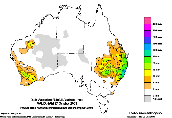
The highest official rainfall totals in the 24 hours to 9am were in the headwaters of the Kalang and Nambucca rivers where Spicketts Creek (Noonannie) registered 398.6mm, Bowra Sugarloaf 345.0 and Kalang (Sharabel) 342.0. Of the flood warning (non-official) rainfall stations, Crystal Creek, about 15km north of Bellingen, had the highest total of 409mm. None of these stations has a long enough set of observations to show up in the records section below, but Coffs Harbour Airport, Woolgoolga and Bellbrook all recorded their heaviest one-day October falls in long rainfall histories. Bellbrook's 117.0mm was its heaviest October fall in 118 years, beating the previous 85.9mm set back in 1927. Woolgoolga's 171.0mm was its heaviest in 108 years (154.9 in 1904). Coffs Harbour Airport Met Office recorded 146.6mm, the heaviest for October since the station opened 53 years ago. Other records are shown below and full details of rainfall are in wettest below.

Bellinger River: The heaviest rain in the Bellinger River basin continued to fall in the headwaters of Never Never Creek to the north of the town of Bellingen. Here, Crystal Creek recorded 399mm between 3pm yesterday and noon today, with the heaviest hourly totals of 38, 38, 20, 57, 43 and 44mm reported successively between 5 and 11pm last night. Because the heaviest floodwaters entered the main river just above Bellingen, near moderate flooding was experienced in Bellingen and below while the upper catchment, including the gauge at Thora, only just reached minor flood levels. The Bellinger at Thora peaked at 2.96m at 1pm today then began falling, but a further burst of local heavy rain late this afternoon and evening pushed the river over the 3.0m minor flood level to peak around 3.2m about 3am Wednesday. The Bellinger at Bellingen peaked just below 6.0m (which is moderate flood level) around 3am today. The town was cut off from the Pacific Hwy with Waterfall Way flooded, and access was cut between Bellingen and North Bellingen with the Lavenders Bridge under water.

Orara River: Glenreagh peaked around 6.8m (moderate flood level 7.0m) about 9pm today.

Kalang River: Torrential rain continued without a break from 2pm yesterday to 4pm today, though it eased to merely moderate or heavy for a few hours late morning before continuing until mid afternoon. At Spicketts Creek (Noonannie), the heaviest periods of rain were 128mm between 4 and 9pm yesterday, 170mm between midnight and 4am today, and 59mm between 10am and 1pm. About 500 people may have been isolated around Kalang according to the SES with the only access, Moody's Bridge, under water.

Nambucca River: Bowra Sugarloaf flood gauge in the upper catchment recorded 458mm falling as steady, heavy rain between 3pm yesterday and 6pm today, after which rain eased. Due to a possible problem with the gauge or telecommunications at Bowraville - shown as a gap in the Bureau of Meteorology flood graph between noon and 9pm -- the time and level of the peak there are not known for certain. A Bureau flood warning gave the peak as "near 10m about 5pm" while a reading of 9.96m and rising at 2.36pm supports this. Major flood level at Bowraville is 10.0m. Roads into Bowraville (population 980) were cut with all low-level bridges under water, isolating the town and about 70 people in the area. The river peaked at 1.6m at Macksville, 0.5m lower than expected and 0.1m below minor level. Up to 100 people around north Macksville were isolated.

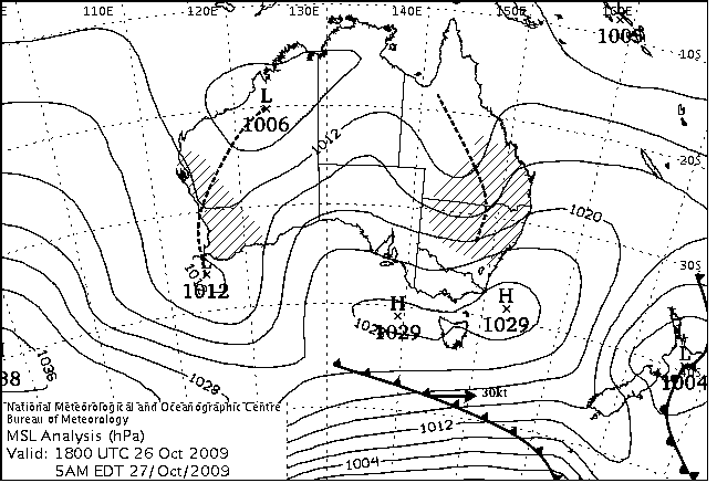
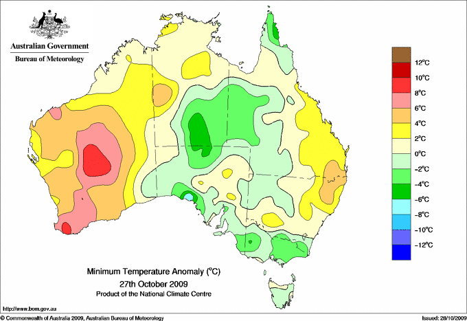
WA: Record high temperatures in the south. The trough shown on the charts below extending from Broome to offshore Perth ducted hot air into southern WA for the third day in a row, giving overnight minima 4 to 10 above average and daytime maxima up to 12 above the norm. In the state's far southwest, some long-standing records for hot nights fell. Bridgetown, Pemberton, Manjimup and Donnybrook all recorded their highest October minimum temperatures in over 50 years of record - see records for the details. When the trough finally moved through this morning it brought thunderstorms and heavy rain, giving many locations across the Central Wheatbelt 10 to 20mm of rain in an hour or less shortly before 9 this morning. Amery Acres recorded 29.0mm, its heaviest October one-day fall in 47 years, while Waeel and Cunderdin also set new records.

QLD: Savage storms hit Capella. Capella, 50km NNW of Emerald in the Central Highlands, has been savaged by two major thunderstorms, one yesterday afternoon and one today. Yesterday's storm dropped 40mm of rain and hail, while wind caused considerable tree damage. This was being cleared today when a second storm struck, dropping 97.4mm in the Post Office gauge with further hail and strong winds. With many drains still clogged from the previous day's storm debris, there was main street business flooding in addition to damage sustained by the golf club, aquatic centre, Bridgeman Park and Peak Downs Community Hall.


Records set or equalled today

These records are based on data that has been checked for gross errors but has not yet been fully validated. They are based on data received as at 1332 EST on 28/10/2009. Help in interpreting these statistics and information on quality control is here.

District Site Today Previous monthly record Previous all time record
if equalled or broken
Comments
Reading Reading Date Years Reading Date Years
Highest daily rainfall

WA

Cent Wheatbelt

010000

AMERY ACRES

29.0

19.8

15/10/1975

47

1 n

WA

Cent Wheatbelt

010230

WAEEL

19.0

14.0

21/10/1932

11

1 n

WA

Cent Wheatbelt

010286

CUNDERDIN AIRFIELD

18.2

17.6

23/10/2008

14

1

NSW

CW Plains N

051158

GIRILAMBONE (WONGALA)

58.4

37.2

18/10/1992

18

1 n

NSW

N Tablelands W

056161

GUYRA (GOWAN BRAE)

52.8

50.6

26/10/2007

37

1 n

NSW

N Tablelands E

057124

POINT LOOKOUT

49.2

32.6

14/10/2001

14

1 n

NSW

MidNorth Coast N

059000

BELLBROOK (EAST STREET)

117.0

85.9

14/10/1927

118

1 n

NSW

MidNorth Coast N

059039

WOOLGOOLGA (CLEAR PLACE)

171.0

154.9

12/10/1904

108

1 n

NSW

MidNorth Coast N

059040

COFFS HARBOUR MO

146.6

110.6

21/10/2004

53

1

Highest minimum temperature

WA

SW & S Coast

009510

BRIDGETOWN COMPARISON

17.2

16.8

17/10/2002

53

1

WA

SW & S Coast

009534

DONNYBROOK

18.1

17.7

21/10/1996

50

1

WA

SW & S Coast

009573

MANJIMUP

17.2

17.2

21/10/1996

51

1 Equal to record.

WA

SW & S Coast

009592

PEMBERTON

17.4

17.0

17/10/2002

52

1

WA

SW & S Coast

009617

BRIDGETOWN

16.8

16.3

24/10/2008

12

1

WA

SW & S Coast

009871

WINDY HARBOUR

17.1

16.5

17/10/2002

24

1

WA

SW & S Coast

009965

BUNBURY

18.1

17.9

21/10/1996

14

1

WA

SW & S Coast

009968

SHANNON

16.5

16.0

24/10/2008

13

1


The day in charts
Surface charts Satellite images Rain & temperatures
4am EST Rainfall -- 24 hours to 9am
Available about 6.30am EST Available about 4.30am EST Available about 2.15pm EST
Week to 9am | SE AUS detail
10am EST Minimum temperature +/- normal
Available about 12.30pm EST Available about 10.30am EST Available about 2.15pm EST next day
Actual temperatures
4pm EST Maximum temperature +/- normal
Available about 6.30pm EST Available about 4.30pm EST Available about 2.15pm EST next day
Actual temperatures
10pm EST Solar Radiation
Available about 12.30am EST Available about 10.30pm EST Available about 2.15am EST next day

Summary of observations

For notes on how to interpret the data and quality control issues, see Daily Weather Summary Help.
**S** and **W** precede data flagged by the Bureau as suspicious or wrong
Data is as received at 06:33EST, 15/05/2012.

Major centres
Max
° C
+/- norm
° C
Min
° C
+/- norm
° C
Grass Min
° C
Rain to 9am mm Evaporation to 9am mm Sunshine hours Wind Run to 9am km (24-hour average km/h) Maximum Gust km/h / hour of occurrence
GERALDTON AIRPORT 23.7 -0.7 16.2 +5.3 14.5 3.6 1.4 -- 168 ( 7.0) 31/13
PERTH AIRPORT 26.7 +4.2 15.6 +5.4 13.5 2.0 0.4 9.2 357 (14.9) 39/16
ALBANY AIRPORT 24.9 +6.2 16.4 +7.3 15.1 25.4 6.4 7.6 223 ( 9.3) 30/14
BUNBURY 23.5 +2.8 18.1 +8.9 -- 1.4 -- -- 231 ( 9.6) 30/13
MANDURAH 23.7 -- 18.2 -- -- 0.4 -- -- 314 (13.1) 26/16
DARWIN AIRPORT 34.3 +1.1 28.0 +3.0 27.5 0.0 9.6 11.3 421 (17.5) 46/15
ALICE SPRINGS AIRPORT 28.8 -2.2 9.9 -4.9 7.2 0.0 13.8 12.2 416 (17.3) 39/09
WHYALLA AERO 25.7 +1.8 11.5 +1.0 -- 0.0 10.0 -- 532 (22.2) 43/17
ADELAIDE (KENT TOWN) 26.3 +4.5 11.9 +0.5 -- 0.0 5.0 12.7 314 (13.1) 43/00
MOUNT GAMBIER AERO 21.2 +3.3 4.8 -2.3 0.1 0.0 3.8 12.3 470 (19.6) 39/07
MOUNT ISA AERO 32.5 -2.1 17.2 -1.4 13.9 0.0 14.0 11.9 -- 39/00
CAIRNS AERO 31.0 +1.5 20.5 -0.1 18.1 0.0 7.0 11.0 242 (10.1) 37/12
TOWNSVILLE AERO 30.3 +0.9 23.8 +3.1 21.6 0.0 10.4 9.9 476 (19.8) 37/08
MACKAY M.O 29.9 +2.3 22.0 +2.3 -- 11.2 -- 7.2 349 (14.5) 41/05
ROCKHAMPTON AERO 29.8 +0.1 20.7 +3.7 20.1 0.0 7.8 -- 351 (14.6) 43/10
BUNDABERG AERO 27.8 +0.9 21.0 +4.4 -- 0.0 9.0 -- 376 (15.7) --
NAMBOUR DPI 26.0 -0.7 18.0 +4.2 -- 41.0 -- -- -- --
COOLANGATTA -- -- 21.4 +5.2 -- 1.2 -- -- 498 (20.8) --
BRISBANE AERO 26.2 +0.7 17.6 +1.9 17.4 58.8 12.2 11.3 458 (19.1) 37/09
TOOWOOMBA AIRPORT 24.5 -0.2 14.7 +1.9 -- 30.6 -- -- 603 (25.1) 61/10
GUNNEDAH RESOURCE CENTRE 24.9 -0.2 13.2 +1.1 11.8 27.6 4.2 -- 303 (12.6) --
COFFS HARBOUR MO 21.0 -2.6 17.3 +3.5 17.0 141.8 -- 0.0 430 (17.9) --
PORT MACQUARIE AIRPORT AWS 19.7 -4.3 16.3 +4.4 -- 21.0 -- -- -- --
WILLIAMTOWN RAAF 20.9 -2.7 14.7 +2.7 13.2 1.8 0.8 0.0 775 (32.3) 44/00
GOSFORD (NARARA RESEARCH STATION) AWS 19.8 -3.9 14.0 +3.3 13.2 14.0 -- -- 191 ( 8.0) 28/23
ORANGE AGRICULTURAL INSTITUTE 15.0 -2.5 9.2 +2.6 6.2 0.2 3.0 3.0 -- --
DUBBO AIRPORT AWS 22.5 -2.3 12.4 +3.0 -- 8.6 -- -- 676 (28.2) 63/08
SYDNEY AIRPORT AMO 19.9 -2.6 14.9 +1.8 13.3 0.2 3.8 0.0 775 (32.3) 44/00
RICHMOND RAAF 17.7 -7.3 13.0 +2.0 12.2 1.4 -- -- 331 (13.8) 48/21
BELLAMBI AWS 19.7 -1.9 14.2 +0.3 -- 0.6 -- -- 736 (30.7) 43/00
CANBERRA AIRPORT 19.8 +0.4 6.6 +0.5 3.1 0.4 4.0 5.3 433 (18.0) 26/09
WAGGA WAGGA AMO 24.4 +3.0 9.9 +2.2 6.6 0.0 8.8 6.0 465 (19.4) 44/08
ALBURY AIRPORT AWS 24.1 +2.5 5.9 -2.1 -- 0.0 -- -- 213 ( 8.9) 26/13
MILDURA AIRPORT 28.4 +4.6 10.2 +0.4 7.4 0.0 8.0 12.0 425 (17.7) 35/08
TATURA INST SUSTAINABLE AG 25.5 +4.6 3.7 -3.8 -- 0.0 5.8 -- 272 (11.3) 28/14
BENDIGO AIRPORT 24.6 +4.3 6.9 +0.6 -- 0.0 -- -- 448 (18.7) 31/23
MELBOURNE REGIONAL OFFICE 21.7 +2.1 9.4 -0.1 6.1 0.0 4.6 -- -- --
GROVEDALE (GEELONG AIRPORT) 19.2 +0.4 5.0 -2.6 -- 0.0 -- -- 355 (14.8) 34/15
BALLARAT AERODROME 21.6 +5.0 5.5 -0.7 -- 0.0 -- -- 584 (24.3) 46/17
LAUNCESTON (TI TREE BEND) 19.0 +1.0 8.2 +1.3 -- 0.0 -- -- 226 ( 9.4) 35/14
HOBART AIRPORT 18.0 +0.7 7.7 +0.2 3.1 0.0 4.0 12.5 367 (15.3) 43/15
Max
° C
+/- norm
° C
Min
° C
+/- norm
° C
Grass Min
° C
Rain to 9am mm Evaporation to 9am mm Sunshine hours Wind Run to 9am km Maximum Gust km/h / hour of occurrence
Hottest
Highest maximum temperature>Greatest variation above normal maximum Highest minimum temperatureGreatest variation above normal minimum

43.2 ROEBOURNE E Pilbara WA
42.8 ROEBOURNE AERO E Pilbara WA
42.7 FITZROY CROSSING AERO W Kimberley WA
42.7 MARBLE BAR E Pilbara WA
42.0 TELFER AERO Interior WA

+11.7 : 32.9 ESPERANCE AERO Lower West WA
+11.6 : 34.9 SALMON GUMS RES.STN. Goldfields WA
+11.3 : 37.1 KALGOORLIE-BOULDER AIRPORT Goldfields WA
+11.1 : 34.0 EYRE Eucla WA
+10.6 : 32.9 RAVENSTHORPE Cent Wheatbelt WA

28.4 DUM IN MIRRIE AWS N Rivers NT
28.2 MARBLE BAR E Pilbara WA
28.2 POINT FAWCETT Islands ISL
28.0 DARWIN AIRPORT N Rivers NT
28.0 TROUGHTON ISLAND N Kimberley WA

+10.4 : 17.2 BRIDGETOWN COMPARISON Lower West WA
+9.9 : 16.8 BRIDGETOWN Lower West WA
+9.8 : 18.1 DONNYBROOK Lower West WA
+9.4 : 16.7 JARRAHWOOD Lower West WA
+9.3 : 23.1 WILUNA Interior WA

Coldest
Lowest maximum temperatureGreatest variation below normal maximum Lowest minimum temperatureGreatest variation below normal minimum

9.0 OBERON (WOODCHEM) C Tablelands S NSW
9.9 MOUNT BOYCE AWS C Tablelands S NSW
10.9 MAATSUYKER ISLAND LIGHTHOUSE Southeast TAS
11.0 LITHGOW (COOERWULL) C Tablelands S NSW
11.1 KATOOMBA (MURRI ST) C Tablelands S NSW

-9.7 : 19.9 CUNNAMULLA POST OFFICE Warrego QLD
-8.6 : 16.6 SCONE AIRPORT AWS Hunter Valley NSW
-8.3 : 17.2 YARRAS (MOUNT SEAVIEW) MidNorth Coast S NSW
-8.0 : 9.0 OBERON (WOODCHEM) C Tablelands S NSW
-7.8 : 9.9 MOUNT BOYCE AWS C Tablelands S NSW

-5.0 THREDBO VILLAGE Snowy Mtns NSW
-4.8 PERISHER VALLEY SKI CENTRE Snowy Mtns NSW
-3.6 CHARLOTTE PASS (KOSCIUSKO CHALET) Snowy Mtns NSW
-3.0 DINNER PLAIN (MOUNT HOTHAM AIRPORT) Upper NE VIC
-1.9 MOUNT HOTHAM Upper NE VIC

**S** -9.5 : -0.6 GRENFELL (QUONDONG RD) SW Slopes N NSW
-7.0 : 2.9 CEDUNA AMO W Agricultural SA
-6.6 : -5.0 THREDBO VILLAGE Snowy Mtns NSW
-6.4 : 2.1 FLINDERS ISLAND AIRPORT Flinders Is/Bass St TAS
-5.9 : 0.2 MORTLAKE RACECOURSE W Coast VIC

Wettest
Sunniest & dullest
Windiest
Highest gusts
Todays highest rainfall totals for the 24 hours to 9am. It includes the top 5 totals nationally followed by all reported falls of 50mm or more.
Highest and lowest recordings of hours of sunshine for the 24 hours to midnight.
Highest wind run totals in kilometres for the 24 hours to 9am (average speed in brackets). All reported runs > =25km/h are shown.
Highest wind gusts in km/h for the 24 hours to midnight followed by the hour in which it occurred. All stations with gusts > 89km/h are shown.
411.0 PROMISED LAND (BELLINGEN (CRYSTAL CREEK) MidNorth Coast N NSW
398.6 KALANG (SPICKETTS CK (NOONANNIE)) MidNorth Coast N NSW
345.0 BOWRA SUGARLOAF MidNorth Coast N NSW
342.0 KALANG (KOOROOWI (SHARABEL)) MidNorth Coast N NSW
300.0 URUNGA (SUNSET PLACE) MidNorth Coast N NSW

QUEENSLAND
Wide Bay/Burnett
61.8 GAYNDAH POST OFFICE
56.6 SAUERS TM
53.8 BYRNESTOWN TM
Brisbane/SE Coast
132.0 DECEPTION BAY ALERT
96.8 MANGO HILL
94.6 BEERBURRUM FOREST STATION
94.0 MT NEBO POST OFFICE
91.6 MT GLORIOUS FAHEY RD
91.0 BOONDALL
84.8 WILSONS PEAK
79.0 MORAYFIELD MARK ST
78.0 SIM JUE CREEK
76.2 SOMERSET DAM
75.2 TOOMBUL BOWLS CLUB
73.2 CARNEYS CREEK "THE RANCH"
72.0 TALLOWOOD
71.4 CLONTARF
71.0 MT BRISBANE
70.0 SPRINGBROOK ROAD
69.0 MT WHITESTONE
66.0 MORAYFIELD ALERT
66.0 PEACHESTER
64.2 HIGHVALE
63.0 YIELO
62.4 LANDSBOROUGH POST OFFICE
62.0 REDCLIFFE
58.8 BRISBANE AERO
58.0 CARBROOK LONGLAND ROAD
57.8 JIMNA FORESTRY
57.6 LOWOOD DON ST
56.6 PALMWOODS
56.0 KILCOY POST OFFICE
55.2 PERSEVERANCE DAM
54.0 COOMINYA POST OFFICE
54.0 GREGORS CREEK
52.0 FERNVALE - BURNS ST
51.0 WILSONS PEAK ALERT
50.0 SAMSONVALE
50.0 BUARABA
50.0 CANNON HILL BOWLS CLUB
50.0 NUMINBAH
50.0 YABBA STATION
Darling Downs E
76.0 TERRAINE TM
Warrego
68.0 WARIDA

NEW SOUTH WALES
CW Plains N
58.4 GIRILAMBONE (WONGALA)
NW Plains E
74.0 BELLATA POST OFFICE
NW Slopes N
52.4 UPPER BINGARA (EMOHTA)
NW Slopes S
61.0 DANGLEMAH (RUTHERGLEN)
N Tablelands W
52.8 GUYRA (GOWAN BRAE)
N Tablelands E
96.2 WOODENBONG (UNUMGAR ST)
83.6 GEORGES CREEK (MURRUNGI)
68.8 LOWER CREEK (CEDAR PARK)
66.4 URBENVILLE OLD POST OFFICE
64.0 OLD KOREELAH (WHITE SWAMP (EDENDALE 2))
63.8 TABULAM POST OFFICE
55.2 KOOKABOOKRA
53.4 TABULAM (MUIRNE)
50.4 GUYRA (MYLOE)
North Coast
220.0 MEERSCHAUM VALE (JENBETDAPH)
180.0 ROSEBANK (REPENTANCE CREEK)
177.0 ROSEBANK (UPPER COOPERS CREEK)
160.0 MEERSCHAUMVALE (MEERSCHAUM VALE (BARDEN)
131.0 ALSTONVILLE TROPICAL FRUIT RESEARCH STAT
127.0 MURWILLUMBAH (TWEED RIVER)
121.2 MURWILLUMBAH (BRAY PARK)
117.0 CLUNES (MAIN RD)
111.0 WOOLI BEACH
109.0 WOOLI (SANDSTONE HILL)
108.0 ILUKA (OWEN ST)
106.6 WOOMBAH (EMU DRIVE)
103.4 WOODBURN POST OFFICE
103.0 BOAT HARBOUR (ROUS RIVER)
101.0 KUNGHUR (THE JUNCTION)
99.2 YAMBA PILOT STATION
97.4 NYMBOIDA (ARMIDALE ROAD)
94.0 COMMISSIONERS CREEK (BLUE RIDGE)
91.0 CHILLINGHAM
90.0 UKI (TWEED RIVER)
90.0 MINNIE WATER PUMP SHED
89.0 HARWOOD ISLAND (HARWOOD SUGAR MILL)
88.0 EWING BRIDGE CORNDALE (COOPERS CK)
88.0 NEW ITALY
81.6 MACLEAN (SOUTH ARM)
79.4 PILLAR VALLEY
78.8 LAWRENCE POST OFFICE
78.6 MURWILLUMBAH (TALESWOOD)
76.0 MOUNT NUMINBAH
72.0 MCLEANS RIDGES (LASCOTT DRIVE)
71.5 EUNGELLA (OXLEY RIVER)
71.0 NASHUA (WILSONS RIVER)
69.2 WOOLNERS ARM
67.0 CHILLINGHAM (LIMPINWOOD)
65.0 DOON DOON (MCCABES ROAD)
54.0 LILLIAN ROCK (WILLIAMS ROAD)
50.2 DAIRY FLAT
MidNorth Coast N
411.0 PROMISED LAND (BELLINGEN (CRYSTAL CREEK)
398.6 KALANG (SPICKETTS CK (NOONANNIE))
345.0 BOWRA SUGARLOAF
342.0 KALANG (KOOROOWI (SHARABEL))
300.0 URUNGA (SUNSET PLACE)
280.2 UPPER ORARA (AURANIA)
252.0 BOWRAVILLE RECREATION CLUB
250.0 BELLINGEN (HYDE STREET)
246.0 BOWRAVILLE (COW COWNTY)
245.4 THUMB CREEK (FIGTREE)
235.2 COOKS CK (KALANG)
213.2 LOWANNA (GRAFTON ST)
188.2 GIRRALONG
172.0 BELLWOOD (NAMBUCCA HEADS (NAMBUCCA RESOR
171.8 CORAMBA (GLENFIDDICH)
171.0 WOOLGOOLGA (CLEAR PLACE)
161.0 LOWER BUCCA
149.0 DORRIGO (OLD CORAMBA RD)
144.4 MACKSVILLE COUNTRY CLUB
142.0 ORAMA (DARKWOOD ROAD)
141.8 COFFS HARBOUR MO
130.0 LEIGH (ROLLING ACRES)
117.0 BELLBROOK (EAST STREET)
113.0 UPPER DARKWOOD
112.0 EUNGAI CREEK (SOUTHBANK ROAD)
108.0 BELLBROOK (MACLEAY RIVER)
108.0 TAYLORS ARM (LEMON GROVE)
103.4 DORRIGO (ELM STREET)
103.0 TAYLORS ARM
99.0 NYMBOIDA (NYMBOIDA RIVER)
84.6 TYRINGHAM (GLENFERNEIGH (RING TREE))
83.8 WILLAWARRIN (DENLEIGH)
82.0 MILLBANK
75.6 MELDRUM (COOLAWARRAH)
75.6 FISHERMANS REACH
70.6 UPPER ORARA (DAIRYVILLE)
69.2 SOUTH WEST ROCKS (SMOKY CAPE LIGHTHOUSE)
63.5 WITTITRIN
61.6 KEMPSEY AIRPORT AWS
53.0 NANA GLEN (COWLING CLOSE)
53.0 TOOROOKA (MOPARRABAH)
52.6 EBOR (THE RACECOURSE)
52.0 MAJORS CREEK (MOPARRABAH (PARRABEL CREEK
MidNorth Coast S
119.2 STRATHCEDAR (MOORAL CREEK RD)
104.6 KILLABAKH
100.4 LANSDOWNE POST OFFICE
89.4 BOBIN (BOBIN CREEK)
86.2 YARRAS (MOUNT SEAVIEW)
81.0 TAREE AIRPORT AWS
80.0 COMBOYNE SOUTH
79.2 WINGHAM (LANARK CLOSE)
75.4 OLD BAR (MOLONG RD)
74.0 UPPER ROLLANDS PLAINS (GREENACRES)
71.4 KILLAWARRA (URALBA)
70.6 ELANDS (BLACK SANDS CREEK)
70.5 ROCKS CROSSING (NOWENDOC RIVER)
67.0 COMBOYNE POST OFFICE
60.0 KRAMBACH (TIPPERARY)
60.0 HALLIDAYS POINT (TALLWOODS GOLF RESORT)
57.6 GLOUCESTER (UPPER BOWMAN)
56.4 UPPER PAPPINBARRA (HILLCREST)
53.2 KRAMBACH (BELLEVUE)
52.6 NUMBER ONE (MURRAYS CREEK)
52.2 COBARK
51.0 NOWENDOC (EMU TOPS)
50.0 LORNE (LORNE ROAD)
Hunter Valley
74.2 UPPER ALLYN TOWNSHIP
55.0 UPPER CHICHESTER (SIMMONDS)
54.4 CAREYS PEAK (BARRINGTON TOPS)

12.7 ADELAIDE (KENT TOWN) Adelaide/Lofty SA
12.6 ADELAIDE AIRPORT Adelaide/Lofty SA
12.6 EAST SALE AIRPORT W Gippsland VIC
12.5 WOOMERA AERODROME NW Pastoral SA
12.5 HOBART AIRPORT Southeast TAS

.....

0.5 INVERELL RESEARCH CENTRE N Tablelands W NSW
0.0 COFFS HARBOUR MO MidNorth Coast N NSW
0.0 WILLIAMTOWN RAAF Hunter Valley NSW
0.0 SCONE SCS Hunter Valley NSW
0.0 SYDNEY AIRPORT AMO Sydney--east NSW

1126 (46.9) MURRURUNDI GAP AWS Hunter Valley NSW
1070 (44.6) MAATSUYKER ISLAND LIGHTHOUSE Southeast TAS
1033 (43.0) NEWCASTLE NOBBYS SIGNAL STATION AWS Hunter Valley NSW
919 (38.3) VARANUS ISLAND Islands ISL
857 (35.7) CAPE WILLOUGHBY Yorke Pen/Kanga Is SA
844 (35.2) ORANGE AIRPORT AWS C Tablelands S NSW
839 (35.0) WILSONS PROMONTORY LIGHTHOUSE W Gippsland VIC
803 (33.5) CAPE MORETON LIGHTHOUSE Brisbane/SE Coast QLD
781 (32.5) BYRON BAY (CAPE BYRON AWS) North Coast NSW
775 (32.3) WILLIAMTOWN RAAF Hunter Valley NSW
775 (32.3) SYDNEY AIRPORT AMO Sydney--east NSW
756 (31.5) NULLO MOUNTAIN AWS C Tablelands N NSW
742 (30.9) BARROW ISLAND AIRPORT W Pilbara WA
736 (30.7) BELLAMBI AWS Illawarra NSW
735 (30.6) DOUBLE ISLAND POINT LIGHTHOUSE Brisbane/SE Coast QLD
715 (29.8) CABRAMURRA SMHEA AWS SW Slopes S NSW
700 (29.2) STENHOUSE BAY Yorke Pen/Kanga Is SA
698 (29.1) MARDIE W Pilbara WA
697 (29.0) COCOS ISLAND AIRPORT Islands ISL
683 (28.5) GRIFFITH AIRPORT AWS Riverina W NSW
679 (28.3) HARTZ MOUNTAIN (KEOGHS PIMPLE) Southeast TAS
677 (28.2) NEPTUNE ISLAND W Agricultural SA
676 (28.2) DUBBO AIRPORT AWS CW Slopes S NSW
674 (28.1) WEST WYALONG AIRPORT AWS CW Plains S NSW
672 (28.0) GUNNEDAH AIRPORT AWS NW Slopes S NSW
662 (27.6) FORBES AIRPORT AWS CW Slopes S NSW
657 (27.4) MAROOCHYDORE AERO Brisbane/SE Coast QLD
657 (27.4) CONDOBOLIN AIRPORT AWS CW Plains S NSW
655 (27.3) IVANHOE AERODROME AWS Southwest Plains NSW
651 (27.1) RUNDLE ISLAND Wide Bay/Burnett QLD
642 (26.8) ONSLOW AIRPORT W Pilbara WA
640 (26.7) MUDGEE AIRPORT AWS C Tablelands N NSW
636 (26.5) GOLD COAST SEAWAY Brisbane/SE Coast QLD
632 (26.3) CAPE BORDA Yorke Pen/Kanga Is SA
631 (26.3) PARAWA (SECOND VALLEY FOREST AWS) Adelaide/Lofty SA
628 (26.2) EDITHBURGH Yorke Pen/Kanga Is SA
626 (26.1) BALLERA GAS FIELD Far SW QLD
623 (26.0) SCONE AIRPORT AWS Hunter Valley NSW
622 (25.9) RHYLL E Central VIC
618 (25.8) MINLATON AERO Yorke Pen/Kanga Is SA
618 (25.8) COLAC (MOUNT GELLIBRAND) W Coast VIC
614 (25.6) TIBOOBURRA AIRPORT Far Northwest NSW
612 (25.5) THEVENARD ISLAND W Pilbara WA
604 (25.2) YOUNG AIRPORT SW Slopes N NSW
603 (25.1) TOOWOOMBA AIRPORT Darling Downs E QLD
70/00 MURRURUNDI GAP AWS Hunter Valley NSW
67/15 MEEKATHARRA AIRPORT E Gascoyne WA
67/03 HARTZ MOUNTAIN (KEOGHS PIMPLE) Southeast TAS
65/23 ARMIDALE AIRPORT AWS N Tablelands W NSW
65/23 ORANGE AIRPORT AWS C Tablelands S NSW
65/23 CABRAMURRA SMHEA AWS SW Slopes S NSW

Downpours High AWS wind reports
High rainfall for periods of 6 hours or less from AWS and synoptic reports. Storm force gusts (>89km/h) and 10-minute mean gales (>62km/h) reported by AWSs. Wind direction and mean windspeed are shown in brackets.
QUEENSLAND
N Peninsula
SCHERGER RAAF
17.8mm in 40 min to 18:40 26.7mm/h
14.0mm in 20 min to 19:00 42.0mm/h
31.8mm in 1 hr to 19:00 31.8mm/h
34.0mm in 3 hr to 21:00 11.3mm/h
Central Coast E
SAMUEL HILL AERO
5.2mm in 11 min to 17:00 28.4mm/h
10.6mm in 54 min to 20:00 11.8mm/h
10.6mm in 1 hr to 20:00 10.6mm/h
Brisbane/SE Coast
NAMBOUR DPI
27.2mm in 1 hr to 00:00 27.2mm/h
38.0mm in 3 hr to 00:00 12.7mm/h
Warrego
CUNNAMULLA POST OFFICE
17.0mm in 3 hr to 09:00 5.7mm/h
NEW SOUTH WALES
CW Plains N
COONAMBLE AIRPORT AWS
19.0mm in 3 hr to 15:00 6.3mm/h
14.0mm in 32 min to 15:01 26.2mm/h
20.0mm in 3 hr to 18:00 6.7mm/h
North Coast
YAMBA PILOT STATION
13.2mm in 1 hr to 02:00 13.2mm/h
31.2mm in 1 hr to 03:00 31.2mm/h
54.0mm in 3 hr to 03:00 18.0mm/h
16.0mm in 3 hr to 15:00 5.3mm/h
18.0mm in 3 hr to 18:00 6.0mm/h
GRAFTON RESEARCH STN
10.4mm in 1 hr to 16:30 10.4mm/h
10.6mm in 1 hr to 17:00 10.6mm/h
19.0mm in 3 hr to 18:00 6.3mm/h
LISMORE AIRPORT AWS
10.6mm in 1 hr to 00:00 10.6mm/h
16.0mm in 3 hr to 00:00 5.3mm/h
MidNorth Coast N
KEMPSEY AIRPORT AWS
15.0mm in 3 hr to 00:00 5.0mm/h
COFFS HARBOUR MO
19.0mm in 3 hr to 00:00 6.3mm/h
13.8mm in 1 hr to 00:30 13.8mm/h
11.0mm in 27 min to 00:57 24.4mm/h
21.2mm in 1 hr to 01:00 21.2mm/h
17.2mm in 1 hr to 01:30 17.2mm/h
12.6mm in 1 hr to 02:00 12.6mm/h
14.8mm in 1 hr to 02:30 14.8mm/h
11.8mm in 1 hr to 03:00 11.8mm/h
46.0mm in 3 hr to 03:00 15.3mm/h
MidNorth Coast S
TAREE AIRPORT AWS
14.8mm in 1 hr to 00:00 14.8mm/h
32.0mm in 3 hr to 00:00 10.7mm/h
CW Slopes N
COONABARABRAN AIRPORT AWS
12.0mm in 1 hr to 19:30 12.0mm/h
17.0mm in 3 hr to 21:00 5.7mm/h
None reported