|
For notes on how to interpret
the data and quality control issues, see Daily Weather Summary Help.
**S** and **W** precede data flagged by the Bureau as suspicious or wrong
Data is as received at 09:30EST, 15/05/2012.
|
|
| |
Max
°
C |
+/- norm
°
C |
Min
°
C |
+/- norm
°
C |
Grass Min
°
C |
Rain to 9am mm |
Evaporation to 9am mm |
Sunshine hours |
Wind Run to 9am km (24-hour average km/h) |
Maximum Gust km/h / hour of occurrence |
| GERALDTON AIRPORT |
41.6 |
+12.1 |
14.9 |
-1.4 |
10.9 |
0.0 |
13.8 |
-- |
454 (18.9) |
41/08 |
| PERTH AIRPORT |
39.0 |
+10.1 |
13.0 |
-1.8 |
11.2 |
0.0 |
11.8 |
13.5 |
414 (17.3) |
37/06 |
| ALBANY AIRPORT |
38.7 |
+15.6 |
13.0 |
+0.6 |
9.6 |
0.0 |
8.0 |
12.1 |
412 (17.2) |
39/10 |
| BUNBURY |
32.4 |
+5.3 |
12.1 |
-1.2 |
-- |
0.0 |
-- |
-- |
232 ( 9.7) |
30/12 |
| MANDURAH |
32.9 |
-- |
19.5 |
-- |
-- |
0.0 |
-- |
-- |
304 (12.7) |
37/15 |
| DARWIN AIRPORT |
27.9 |
-4.7 |
24.0 |
-1.3 |
23.9 |
162.2 |
11.1 |
0.0 |
452 (18.8) |
46/12 |
| ALICE SPRINGS AIRPORT |
30.4 |
-5.0 |
19.4 |
-0.8 |
18.3 |
0.0 |
11.0 |
8.7 |
379 (15.8) |
41/15 |
| WHYALLA AERO |
24.0 |
-4.1 |
15.3 |
-0.5 |
-- |
0.0 |
8.0 |
-- |
478 (19.9) |
50/17 |
| ADELAIDE (KENT TOWN) |
26.2 |
-0.8 |
12.6 |
-2.9 |
10.0 |
0.0 |
-- |
12.1 |
287 (12.0) |
35/17 |
| MOUNT GAMBIER AERO |
19.4 |
-3.5 |
12.7 |
+2.8 |
11.0 |
1.0 |
4.0 |
0.7 |
443 (18.5) |
37/12 |
| MOUNT ISA AERO |
38.7 |
+1.5 |
26.5 |
+3.4 |
24.5 |
0.0 |
13.2 |
1.1 |
517 (21.5) |
55/23 |
| CAIRNS AERO |
32.5 |
+1.1 |
22.7 |
-0.7 |
19.9 |
0.6 |
7.2 |
10.6 |
363 (15.1) |
44/13 |
| TOWNSVILLE AERO |
32.2 |
+0.7 |
24.7 |
+0.6 |
22.2 |
0.0 |
12.4 |
12.1 |
472 (19.7) |
43/11 |
| MACKAY M.O |
30.7 |
+0.6 |
25.7 |
+2.8 |
-- |
0.0 |
-- |
11.5 |
349 (14.5) |
31/13 |
| ROCKHAMPTON AERO |
33.7 |
+1.6 |
23.1 |
+1.9 |
21.8 |
0.0 |
10.8 |
-- |
285 (11.9) |
31/13 |
| BUNDABERG AERO |
32.6 |
+3.2 |
23.4 |
+2.9 |
-- |
0.0 |
9.6 |
-- |
288 (12.0) |
34/13 |
| NAMBOUR DPI |
31.0 |
+1.8 |
20.0 |
+1.8 |
-- |
0.6 |
-- |
-- |
-- |
-- |
| COOLANGATTA |
29.8 |
+2.6 |
21.5 |
+1.6 |
-- |
0.0 |
-- |
-- |
275 (11.5) |
30/11 |
| BRISBANE AERO |
31.1 |
+2.8 |
22.5 |
+2.4 |
20.0 |
0.0 |
8.0 |
-- |
309 (12.9) |
39/14 |
| TOOWOOMBA AIRPORT |
30.6 |
+2.9 |
19.7 |
+3.0 |
-- |
1.6 |
-- |
-- |
490 (20.4) |
37/00 |
| GUNNEDAH RESOURCE CENTRE |
36.1 |
+5.1 |
16.7 |
-0.8 |
6.4 |
0.0 |
8.8 |
-- |
128 ( 5.3) |
-- |
| COFFS HARBOUR MO |
27.2 |
+0.9 |
17.2 |
-0.9 |
14.4 |
0.0 |
4.2 |
11.5 |
245 (10.2) |
37/15 |
| PORT MACQUARIE AIRPORT AWS |
28.4 |
+1.8 |
15.0 |
-1.7 |
-- |
0.0 |
-- |
-- |
-- |
-- |
| WILLIAMTOWN RAAF |
27.5 |
+0.3 |
14.7 |
-1.8 |
13.0 |
0.0 |
7.8 |
10.3 |
358 (14.9) |
41/14 |
| GOSFORD (NARARA RESEARCH STATION) AWS |
27.5 |
+0.6 |
14.9 |
-0.4 |
-- |
0.0 |
-- |
-- |
98 ( 4.1) |
34/12 |
| ORANGE AGRICULTURAL INSTITUTE |
27.8 |
+3.4 |
9.1 |
-2.2 |
1.6 |
0.0 |
8.0 |
13.5 |
-- |
-- |
| DUBBO AIRPORT AWS |
34.6 |
+3.1 |
13.3 |
-2.6 |
-- |
0.0 |
-- |
-- |
278 (11.6) |
39/16 |
| SYDNEY AIRPORT AMO |
26.1 |
+0.4 |
20.2 |
+2.7 |
17.8 |
0.0 |
8.4 |
11.1 |
510 (21.3) |
43/14 |
| RICHMOND RAAF |
32.4 |
+3.7 |
17.6 |
+1.6 |
13.5 |
0.0 |
-- |
-- |
205 ( 8.5) |
46/13 |
| BELLAMBI AWS |
24.5 |
+0.4 |
18.6 |
+1.1 |
-- |
0.0 |
-- |
-- |
400 (16.7) |
39/21 |
| CANBERRA AIRPORT |
32.1 |
+6.0 |
9.3 |
-2.1 |
5.9 |
0.0 |
10.2 |
13.7 |
330 (13.8) |
59/16 |
| WAGGA WAGGA AMO |
32.5 |
+3.1 |
12.2 |
-1.5 |
8.4 |
0.0 |
9.6 |
13.8 |
292 (12.2) |
43/12 |
| ALBURY AIRPORT AWS |
29.6 |
+0.2 |
11.8 |
-1.9 |
-- |
0.0 |
-- |
-- |
199 ( 8.3) |
43/17 |
| MILDURA AIRPORT |
29.1 |
-1.0 |
12.4 |
-2.4 |
10.9 |
0.0 |
10.2 |
11.6 |
380 (15.8) |
31/23 |
| TATURA INST SUSTAINABLE AG |
25.4 |
-2.0 |
12.4 |
+0.2 |
-- |
0.0 |
-- |
-- |
339 (14.1) |
43/15 |
| BENDIGO AIRPORT |
24.7 |
-2.3 |
10.2 |
-1.3 |
-- |
0.0 |
-- |
-- |
316 (13.2) |
�
43/17 |
| MELBOURNE REGIONAL OFFICE |
21.5 |
-2.7 |
14.9 |
+2.0 |
15.4 |
0.0 |
3.0 |
-- |
-- |
-- |
| GEELONG AIRPORT |
21.5 |
-1.4 |
13.1 |
+2.2 |
-- |
0.0 |
-- |
-- |
492 (20.5) |
46/16 |
| BALLARAT AERODROME |
18.9 |
-3.7 |
11.0 |
+1.6 |
-- |
0.6 |
-- |
-- |
398 (16.6) |
35/18 |
| LAUNCESTON (TI TREE BEND) |
24.6 |
+2.2 |
11.4 |
+0.8 |
-- |
0.0 |
-- |
-- |
387 (16.1) |
37/19 |
| HOBART AIRPORT |
16.2 |
-4.4 |
11.7 |
+1.0 |
5.8 |
0.0 |
6.6 |
4.3 |
578 (24.1) |
44/19 |
| |
Max
°
C |
+/- norm
°
C |
Min
°
C |
+/- norm
°
C |
Grass Min
°
C |
Rain to 9am mm |
Evaporation to 9am mm |
Sunshine hours |
Wind Run to 9am km |
Maximum Gust km/h / hour of occurrence |
|
| Hottest |
| Highest maximum temperature> | Greatest variation above normal maximum |
Highest minimum temperature | Greatest variation above normal minimum |
43.2 CURTIN AERO W Kimberley WA
42.9 WEST ROEBUCK W Kimberley WA
42.7 DERBY AERO W Kimberley WA
42.6 FITZROY CROSSING AERO W Kimberley WA
42.4 EMU CREEK STATION W Gascoyne WA
42.4 MURCHISON W Gascoyne WA
|
+15.6 : 38.7 ALBANY AIRPORT Lower West WA
+13.7 : 38.0 HOPETOUN NORTH Lower West WA
+12.9 : 38.8 JACUP Cent Wheatbelt WA
+12.8 : 40.0 LANCELIN Lower West WA
|
29.9 WARMUN E Kimberley WA
29.0 MARBLE BAR E Pilbara WA
28.8 BROOME AIRPORT W Kimberley WA
28.7 SWEERS ISLAND Gulf Country QLD
28.5 NORMANTON AIRPORT Gulf Country QLD
|
+6.1 : 20.0 CAPE NATURALISTE Lower West WA
+5.5 : 20.5 SOUTHERN CROSS AIRFIELD Goldfields WA
+5.4 : 23.5 UNIVERSITY OF QUEENSLAND GATTON Brisbane/SE Coast QLD
+5.0 : 21.6 OAKEY AERO Darling Downs E QLD
+5.0 : 18.0 HARVEY Lower West WA
|
| Coldest |
| Lowest maximum temperature | Greatest variation below normal maximum |
Lowest minimum temperature | Greatest variation below normal minimum |
6.6 MOUNT READ W Coast TAS
8.2 HARTZ MOUNTAIN (KEOGHS PIMPLE) Southeast TAS
9.4 MT BAW BAW W Gippsland VIC
10.0 MOUNT WELLINGTON Southeast TAS
11.0 GRAMPIANS (MOUNT WILLIAM) Wimmera S VIC
|
-13.3 : 24.5 JERVOIS N Plateau NT
-11.2 : 23.0 ARLTUNGA N Plateau NT
-8.8 : 26.0 MANGO FARM N Rivers NT
-8.7 : 27.6 TERRITORY GRAPE FARM N Plateau NT
-7.9 : 27.0 DOUGLAS RIVER N Rivers NT
|
2.0 MOUNT WELLINGTON Southeast TAS
2.5 THREDBO VILLAGE Snowy Mtns NSW
2.8 CHARLOTTE PASS (KOSCIUSKO CHALET) Snowy Mtns NSW
3.1 MOUNT READ W Coast TAS
3.6 MT HOTHAM Upper NE VIC
|
-8.6 : 14.7 THARGOMINDAH AIRPORT Far SW QLD
-7.0 : 6.7 COULTA (COLES POINT) W Agricultural SA
-6.2 : 14.3 KULGERA N Plateau NT
-6.0 : 15.4 JERVOIS N Plateau NT
-5.7 : 8.4 EYRE Eucla WA
|
|
Sunniest &
dullest |
Windiest |
Highest gusts |
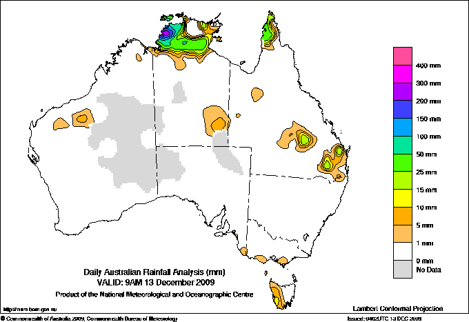
Todays highest rainfall totals for the 24 hours to 9am. It
includes the top 5 totals nationally followed by all reported falls of 50mm or more. |
Highest
and lowest recordings of hours of sunshine for the 24 hours to midnight. |
Highest wind
run totals in kilometres for the 24 hours to 9am (average speed in brackets).
All reported runs >
=25km/h are shown. |
Highest wind
gusts in km/h for the 24 hours to midnight followed by the hour in which it occurred.
All stations with gusts >
89km/h are shown. |
290.2 CHANNEL ISLAND N Rivers NT
285.0 DARWIN RIVER DAM N Rivers NT
280.0 WALKER CREEK N Rivers NT
273.6 STOKES HILL N Rivers NT
240.2 SOUTHPORT N Rivers NT
NORTHERN TERRITORY
N Rivers
290.2 CHANNEL ISLAND
285.0 DARWIN RIVER DAM
280.0 WALKER CREEK
273.6 STOKES HILL
240.2 SOUTHPORT
238.8 DARWIN RIVER RIDGE
235.0 RANKIN POINT
229.0 LITCHFIELD
226.2 DARWIN BOTANIC GARDENS
223.6 BATCHELOR AERO
194.6 TERRITORY WILDLIFE PARK
188.4 CHANNEL POINT
179.6 BERRY SPRINGS RANGERS
162.2 DARWIN AIRPORT
141.0 BERRIMAH RESEARCH FARM
138.0 ADELAIDE RIVER POST OFFICE
136.6 MAJESTIC ORCHIDS
120.2 GERIATRIC PARK
117.2 UPPER ADELAIDE RIVER
117.0 NORTHLAKES
117.0 MOUNT BUNDY STATION
111.8 MANGO FARM
111.0 PINELANDS
104.4 ROSEBERY
104.0 POINT STUART AWS
97.6 THE CHASE
84.6 KARAMA
80.2 MIDDLE POINT AWS
74.4 HOWARD SPRINGS
73.0 NIGHTCLIFF POOL
72.8 LEANYER
72.0 SHOAL BAY
65.4 DOUGLAS RIVER
65.0 ELIZABETH VALLEY
64.6 DUM IN MIRRIE AWS
64.6 NOONAMAH AWS
62.7 ACACIA, MOCATTO ROAD
58.4 HUMPTY DOO COLLARD ROAD
57.2 WILDMAN RANGERS
56.2 WAGAIT BEACH
55.0 NITMILUK RANGERS
54.0 MCMINNS LAGOON
53.0 BONALBO
52.8 KATHERINE AVIATION MUSEUM
50.0 BEATRICE HILL
|
13.8 WAGGA WAGGA AMO SW Slopes S NSW
13.7 CANBERRA AIRPORT Goulburn/Monaro NSW
13.6 WOOMERA AERODROME NW Pastoral SA
13.6 CEDUNA AMO W Agricultural SA
13.5 PERTH AIRPORT Lower West WA
13.5 LOXTON RESEARCH CENTRE Murray Valley SA
13.5 ORANGE AGRICULTURAL INSTITUTE C Tablelands S NSW
.....
1.1 MOUNT ISA AERO Gulf Country QLD
0.9 TENNANT CREEK AIRPORT N Plateau NT
0.7 MOUNT GAMBIER AERO Lower SE SA
0.5 STRATHGORDON VILLAGE W Coast TAS
0.0 DARWIN AIRPORT N Rivers NT
|
1632 (68.0) MAATSUYKER ISLAND LIGHTHOUSE Southeast TAS
1512 (63.0) MOUNT WELLINGTON Southeast TAS
**S** 1466 (61.1) HOGAN ISLAND Islands ISL
1252 (52.2) CAPE GRIM BAPS N Coast TAS
1175 (49.0) FLINDERS ISLAND AIRPORT Flinders Is/Bass St TAS
1108 (46.2) WILSONS PROMONTORY LIGHTHOUSE W Gippsland VIC
1014 (42.3) LOW HEAD N Coast TAS
1008 (42.0) SCOTTS PEAK DAM W Coast TAS
980 (40.8) MOUNT READ W Coast TAS
945 (39.4) SWAN ISLAND E Coast TAS
944 (39.3) HARTZ MOUNTAIN (KEOGHS PIMPLE) Southeast TAS
930 (38.8) LIAWENEE Central Plateau TAS
881 (36.7) CAPE BRUNY (CAPE BRUNY) Southeast TAS
783 (32.6) GABO ISLAND LIGHTHOUSE E Gippsland VIC
780 (32.5) DEVONPORT AIRPORT N Coast TAS
777 (32.4) CAPE OTWAY LIGHTHOUSE W Coast VIC
765 (31.9) EDDYSTONE POINT E Coast TAS
759 (31.6) RED ROCKS POINT Eucla WA
752 (31.3) KING ISLAND AIRPORT King Island TAS
738 (30.8) SMITHTON AERODROME N Coast TAS
732 (30.5) WYNYARD AIRPORT N Coast TAS
727 (30.3) COLAC (MOUNT GELLIBRAND) W Coast VIC
707 (29.5) HAMILTON ISLAND AIRPORT Central Coast E QLD
678 (28.3) CAMPANIA (KINCORA) Southeast TAS
659 (27.5) PORT FAIRY AWS W Coast VIC
650 (27.1) WILLIS ISLAND Islands ISL
638 (26.6) SHEFFIELD SCHOOL FARM N Coast TAS
634 (26.4) EAST SALE AIRPORT W Gippsland VIC
633 (26.4) STRAHAN AERODROME W Coast TAS
611 (25.5) NULLARBOR W Agricultural SA
|
115/01 MOUNT WELLINGTON Southeast TAS
102/00 HARTZ MOUNTAIN (KEOGHS PIMPLE) Southeast TAS
85/02 MAATSUYKER ISLAND LIGHTHOUSE Southeast TAS
83/23 HOGAN ISLAND Islands ISL
81/18 WILSONS PROMONTORY LIGHTHOUSE W Gippsland VIC
|
�