|
For notes on how to interpret
the data and quality control issues, see Daily Weather Summary Help.
**S** and **W** precede data flagged by the Bureau as suspicious or wrong
Data is as received at 04:00EST, 15/05/2012.
|
|
| |
Max
°
C |
+/- norm
°
C |
Min
°
C |
+/- norm
°
C |
Grass Min
°
C |
Rain to 9am mm |
Evaporation to 9am mm |
Sunshine hours |
Wind Run to 9am km (24-hour average km/h) |
Maximum Gust km/h / hour of occurrence |
| GERALDTON AIRPORT |
37.4 |
+6.5 |
18.1 |
+0.2 |
12.4 |
0.0 |
12.4 |
-- |
463 (19.3) |
44/08 |
| PERTH AIRPORT |
35.3 |
+5.7 |
15.0 |
-0.8 |
13.3 |
0.0 |
10.0 |
11.6 |
362 (15.1) |
37/15 |
| ALBANY AIRPORT |
32.2 |
+8.1 |
13.7 |
+0.3 |
10.7 |
0.0 |
4.2 |
9.4 |
412 (17.2) |
28/13 |
| BUNBURY |
29.6 |
+2.1 |
11.8 |
-2.2 |
-- |
0.0 |
-- |
-- |
122 ( 5.1) |
31/12 |
| MANDURAH |
29.0 |
-- |
18.8 |
-- |
-- |
0.0 |
-- |
-- |
220 ( 9.2) |
24/15 |
| DARWIN AIRPORT |
33.5 |
+1.6 |
26.6 |
+2.1 |
24.8 |
0.0 |
7.0 |
9.3 |
369 (15.4) |
35/14 |
| ALICE SPRINGS AIRPORT |
32.5 |
-0.2 |
16.5 |
-1.0 |
14.8 |
0.0 |
10.4 |
11.5 |
291 (12.1) |
34/09 |
| WHYALLA AERO |
28.1 |
+0.8 |
19.2 |
+3.9 |
-- |
0.0 |
-- |
-- |
500 (20.8) |
52/17 |
| ADELAIDE (KENT TOWN) |
29.6 |
+3.3 |
15.1 |
-0.1 |
-- |
0.0 |
-- |
11.9 |
226 ( 9.4) |
30/16 |
| MOUNT GAMBIER AERO |
23.6 |
+0.5 |
9.2 |
-1.3 |
6.9 |
0.0 |
4.0 |
11.2 |
408 (17.0) |
43/14 |
| MOUNT ISA AERO |
36.4 |
+2.1 |
18.0 |
-3.8 |
16.4 |
0.0 |
5.8 |
10.5 |
164 ( 6.8) |
30/14 |
| CAIRNS AERO |
30.9 |
+0.4 |
23.8 |
+0.8 |
21.6 |
2.6 |
5.6 |
7.9 |
192 ( 8.0) |
28/13 |
| TOWNSVILLE AERO |
31.5 |
+0.8 |
24.5 |
+1.6 |
23.2 |
3.0 |
5.6 |
9.0 |
276 (11.5) |
34/14 |
| MACKAY M.O |
30.6 |
+2.0 |
22.7 |
+0.5 |
-- |
14.0 |
-- |
6.8 |
655 (27.3) |
34/00 |
| ROCKHAMPTON AERO |
30.0 |
-0.5 |
23.4 |
+2.6 |
21.9 |
1.4 |
4.0 |
-- |
534 (22.3) |
52/09 |
| BUNDABERG AERO |
25.0 |
-4.1 |
21.5 |
+1.6 |
-- |
6.2 |
4.2 |
-- |
660 (27.5) |
57/16 |
| NAMBOUR DPI |
24.0 |
-3.9 |
22.0 |
+3.8 |
-- |
0.0 |
-- |
-- |
-- |
-- |
| COOLANGATTA |
28.1 |
+0.9 |
23.2 |
+3.6 |
-- |
0.0 |
-- |
-- |
424 (17.7) |
50/12 |
| BRISBANE AERO |
26.1 |
-1.9 |
24.0 |
+4.7 |
21.6 |
0.0 |
9.8 |
0.0 |
462 (19.3) |
-- |
| TOOWOOMBA AIRPORT |
25.8 |
-0.6 |
17.0 |
+0.9 |
-- |
0.0 |
-- |
-- |
917 (38.2) |
76/09 |
| GUNNEDAH RESOURCE CENTRE |
30.3 |
+1.2 |
17.8 |
+1.2 |
15.0 |
0.0 |
7.0 |
-- |
261 (10.9) |
-- |
| COFFS HARBOUR MO |
25.7 |
-0.2 |
19.1 |
+1.0 |
13.9 |
0.2 |
5.0 |
5.8 |
364 (15.2) |
43/16 |
| PORT MACQUARIE AIRPORT AWS |
23.7 |
-2.6 |
18.6 |
+1.9 |
-- |
29.0 |
-- |
-- |
-- |
-- |
| WILLIAMTOWN RAAF |
25.8 |
-0.4 |
17.5 |
+1.2 |
15.1 |
0.0 |
7.2 |
11.0 |
408 (17.0) |
41/09 |
| GOSFORD (NARARA RESEARCH STATION) AWS |
24.4 |
-1.6 |
17.1 |
+1.8 |
16.2 |
39.8 |
-- |
-- |
69 ( 2.9) |
21/16 |
| ORANGE AGRICULTURAL INSTITUTE |
25.5 |
+2.7 |
13.3 |
+2.7 |
9.0 |
0.0 |
4.0 |
9.8 |
-- |
-- |
| DUBBO AIRPORT AWS |
31.4 |
+2.3 |
17.5 |
+3.0 |
-- |
0.0 |
-- |
-- |
482 (20.1) |
50/19 |
| SYDNEY AIRPORT AMO |
24.3 |
-0.9 |
17.9 |
+0.5 |
17.7 |
0.0 |
2.0 |
4.4 |
605 (25.2) |
39/01 |
| RICHMOND RAAF |
25.6 |
-1.3 |
16.8 |
+1.3 |
-- |
17.4 |
-- |
-- |
276 (11.5) |
46/03 |
| BELLAMBI AWS |
23.8 |
-0.1 |
17.1 |
-0.9 |
-- |
0.4 |
-- |
-- |
447 (18.6) |
31/23 |
| CANBERRA AIRPORT |
25.9 |
+1.4 |
14.7 |
+4.0 |
14.2 |
0.0 |
5.8 |
6.1 |
338 (14.1) |
34/16 |
| WAGGA WAGGA AMO |
31.3 |
+3.6 |
17.6 |
+4.2 |
16.9 |
0.0 |
7.4 |
11.6 |
329 (13.7) |
43/07 |
| ALBURY AIRPORT AWS |
31.8 |
+3.9 |
13.8 |
+1.2 |
-- |
0.0 |
-- |
-- |
93 ( 3.9) |
24/13 |
| MILDURA AIRPORT |
32.0 |
+3.7 |
12.4 |
-1.4 |
11.0 |
0.0 |
8.8 |
11.5 |
331 (13.8) |
26/08 |
| TATURA INST SUSTAINABLE AG |
30.7 |
+4.4 |
10.5 |
-1.2 |
-- |
0.0 |
-- |
-- |
394 (16.4) |
28/23 |
| BENDIGO AIRPORT |
30.5 |
+4.5 |
11.0 |
-0.3 |
-- |
0.0 |
-- |
-- |
408 (17.0) |
�
31/02 |
| MELBOURNE REGIONAL OFFICE |
25.2 |
+1.3 |
9.7 |
-3.5 |
7.9 |
0.0 |
2.6 |
-- |
144 ( 6.0) |
15/12 |
| GEELONG AIRPORT |
21.3 |
-1.9 |
8.4 |
-3.4 |
-- |
0.0 |
-- |
-- |
304 (12.7) |
41/16 |
| BALLARAT AERODROME |
26.2 |
+4.0 |
9.2 |
-0.7 |
-- |
0.0 |
-- |
-- |
741 (30.9) |
52/23 |
| LAUNCESTON (TI TREE BEND) |
22.7 |
+0.2 |
10.6 |
+0.6 |
-- |
0.0 |
-- |
-- |
167 ( 7.0) |
31/16 |
| HOBART AIRPORT |
17.8 |
-2.9 |
8.0 |
-2.7 |
5.4 |
0.0 |
4.6 |
9.5 |
381 (15.9) |
37/16 |
| |
Max
°
C |
+/- norm
°
C |
Min
°
C |
+/- norm
°
C |
Grass Min
°
C |
Rain to 9am mm |
Evaporation to 9am mm |
Sunshine hours |
Wind Run to 9am km |
Maximum Gust km/h / hour of occurrence |
|
| Hottest |
| Highest maximum temperature> | Greatest variation above normal maximum |
Highest minimum temperature | Greatest variation above normal minimum |
40.1 SHARK BAY AIRPORT W Gascoyne WA
40.0 KALBARRI Central West WA
39.5 ENEABBA Central West WA
39.4 MOOMBA AIRPORT NE Pastoral SA
39.0 DENHAM W Gascoyne WA
|
+8.3 : 33.0 MANJIMUP Lower West WA
+8.1 : 39.0 DENHAM W Gascoyne WA
+8.1 : 32.2 ALBANY AIRPORT Lower West WA
+8.0 : 33.1 ROCKY GULLY Lower West WA
|
28.7 DUM IN MIRRIE AWS N Rivers NT
28.3 CYGNET BAY W Kimberley WA
28.1 MCCLUER ISLAND N Rivers NT
27.9 CHANNEL POINT N Rivers NT
27.3 VARANUS ISLAND Islands ISL
|
+5.5 : 23.0 THANGOOL AIRPORT Wide Bay/Burnett QLD
+5.2 : 21.0 ARKAROOLA NE Pastoral SA
+5.1 : 15.8 YOUNG AIRPORT SW Slopes N NSW
+5.0 : 15.3 BATHURST AIRPORT AWS C Tablelands S NSW
+5.0 : 25.6 QUILPIE AIRPORT Far SW QLD
|
| Coldest |
| Lowest maximum temperature | Greatest variation below normal maximum |
Lowest minimum temperature | Greatest variation below normal minimum |
10.7 MOUNT WELLINGTON Southeast TAS
11.7 MOUNT READ W Coast TAS
13.9 MAATSUYKER ISLAND LIGHTHOUSE Southeast TAS
14.0 TASMAN ISLAND Southeast TAS
14.0 WARRA W Coast TAS
|
-7.2 : 19.6 YARRAS (MOUNT SEAVIEW) MidNorth Coast S NSW
-6.7 : 23.0 TOOLARA (KELLY) Brisbane/SE Coast QLD
-5.8 : 20.4 JIMNA FORESTRY Brisbane/SE Coast QLD
-5.7 : 22.0 KEMPSEY (WIDE STREET) MidNorth Coast N NSW
-5.6 : 23.7 GYMPIE Brisbane/SE Coast QLD
|
0.0 CHARLOTTE PASS (KOSCIUSKO CHALET) Snowy Mtns NSW
0.5 MOUNT WELLINGTON Southeast TAS
0.5 LIAWENEE Central Plateau TAS
1.3 LAKE ST CLAIR NATIONAL PARK Central Plateau TAS
|
-8.3 : 12.1 TOM PRICE W Pilbara WA
-7.6 : 2.0 MORTLAKE RACECOURSE W Coast VIC
-7.0 : 3.4 WARRNAMBOOL AIRPORT NDB W Coast VIC
-6.7 : 15.8 DALY WATERS AWS N Rivers NT
|
|
Sunniest &
dullest |
Windiest |
Highest gusts |
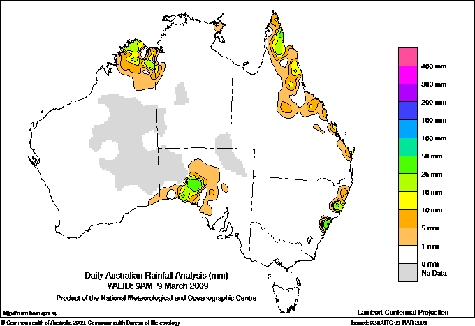
Todays highest rainfall totals for the 24 hours to 9am. It
includes the top 5 totals nationally followed by all reported falls of 50mm or more. |
Highest
and lowest recordings of hours of sunshine for the 24 hours to midnight. |
Highest wind
run totals in kilometres for the 24 hours to 9am (average speed in brackets).
All reported runs >
=25km/h are shown. |
Highest wind
gusts in km/h for the 24 hours to midnight followed by the hour in which it occurred.
All stations with gusts >
89km/h are shown. |
116.8 NORTH TURRAMURRA (DRYDEN RD) Sydney--east NSW
112.4 DUFFYS FOREST (NAMBA RD) Sydney--east NSW
111.0 ST IVES (RICHMOND AVENUE) Sydney--east NSW
88.0 AVALON (WOLLSTONECRAFT AVE) Sydney--east NSW
85.4 TERREY HILLS AWS Sydney--east NSW
QUEENSLAND
N Coast--Barron
77.0 MULGRAVE MILL
50.0 BUTCHER HILL STATION
NEW SOUTH WALES
Hunter Valley
54.0 WYONG (MOUNT ELLIOT)
Sydney--east
116.8 NORTH TURRAMURRA (DRYDEN RD)
112.4 DUFFYS FOREST (NAMBA RD)
111.0 ST IVES (RICHMOND AVENUE)
88.0 AVALON (WOLLSTONECRAFT AVE)
85.4 TERREY HILLS AWS
70.0 TURRAMURRA (KISSING POINT ROAD)
69.5 PYMBLE (CANISIUS COLLEGE)
67.4 AVALON BEACH (AVALON (PALMGROVE RD))
62.4 WEST PYMBLE (WYUNA ROAD)
62.0 CASTLE COVE (ROSEBRIDGE AVE)
61.6 NEWPORT BOWLING CLUB
58.8 CROMER GOLF CLUB
58.6 PENNANT HILLS (YARRARA ROAD)
55.0 BELROSE (EVELYN PLACE)
51.2 ROSE BAY (ROYAL SYDNEY GOLF CLUB)
Sydney--west
66.6 HORNSBY (SWIMMING POOL)
54.0 DURAL (OLD NORTHERN ROAD)
ISLANDS
Islands
52.6 MIDDLE PERCY ISLAND
|
11.9 ADELAIDE (KENT TOWN) Adelaide/Lofty SA
11.8 GILES METEOROLOGICAL OFFICE Interior WA
11.8 ADELAIDE AIRPORT Adelaide/Lofty SA
11.8 LIAWENEE Central Plateau TAS
11.6 PERTH AIRPORT Lower West WA
11.6 NURIOOTPA VITICULTURAL Adelaide/Lofty SA
11.6 WAGGA WAGGA AMO SW Slopes S NSW
.....
4.7 WOOMERA AERODROME NW Pastoral SA
4.4 SYDNEY AIRPORT AMO Sydney--east NSW
3.2 SCONE SCS Hunter Valley NSW
2.4 WEIPA AERO N Peninsula QLD
0.0 BRISBANE AERO Brisbane/SE Coast QLD
|
1450 (60.4) RUNDLE ISLAND Wide Bay/Burnett QLD
1161 (48.4) DOUBLE ISLAND POINT LIGHTHOUSE Brisbane/SE Coast QLD
1093 (45.5) LADY ELLIOT ISLAND Wide Bay/Burnett QLD
1068 (44.5) HERON ISLAND RES STN Wide Bay/Burnett QLD
917 (38.2) TOOWOOMBA AIRPORT Darling Downs E QLD
823 (34.3) GOLD COAST SEAWAY Brisbane/SE Coast QLD
791 (33.0) CAPE WILLOUGHBY Yorke Pen/Kanga Is SA
747 (31.1) STENHOUSE BAY Yorke Pen/Kanga Is SA
743 (31.0) HAMILTON ISLAND AIRPORT Central Coast E QLD
741 (30.9) BALLARAT AERODROME Western Plains VIC
737 (30.7) GLADSTONE RADAR Wide Bay/Burnett QLD
736 (30.7) OAKEY AERO Darling Downs E QLD
729 (30.4) MAROOCHYDORE AERO Brisbane/SE Coast QLD
672 (28.0) MURRURUNDI GAP AWS Hunter Valley NSW
663 (27.6) EDITHBURGH Yorke Pen/Kanga Is SA
660 (27.5) BUNDABERG AERO Wide Bay/Burnett QLD
655 (27.3) MACKAY M.O Central Coast E QLD
652 (27.2) YEPPOON THE ESPLANADE Central Coast E QLD
651 (27.1) BYRON BAY (CAPE BYRON AWS) North Coast NSW
650 (27.1) WILSONS PROMONTORY LIGHTHOUSE W Gippsland VIC
649 (27.0) WOOMERA AERODROME NW Pastoral SA
632 (26.3) DALBY AIRPORT Darling Downs E QLD
630 (26.3) NEPTUNE ISLAND W Agricultural SA
623 (26.0) CAPE JAFFA (THE LIMESTONE) Lower SE SA
619 (25.8) WALLAN (KILMORE GAP) N Central VIC
617 (25.7) ROXBY DOWNS (OLYMPIC DAM AERODROME) NW Pastoral SA
614 (25.6) MARYBOROUGH Brisbane/SE Coast QLD
614 (25.6) HOGAN ISLAND Islands ISL
605 (25.2) SYDNEY AIRPORT AMO Sydney--east NSW
603 (25.1) CAPE BORDA Yorke Pen/Kanga Is SA
|
104/18 HERON ISLAND RES STN Wide Bay/Burnett QLD
98/21 LADY ELLIOT ISLAND Wide Bay/Burnett QLD
93/16 DOUBLE ISLAND POINT LIGHTHOUSE Brisbane/SE Coast QLD
89/00 RUNDLE ISLAND Wide Bay/Burnett QLD
87/ SANDY CAPE LIGHTHOUSE Wide Bay/Burnett QLD
|
�