Saturday 03 FEB 2007
 

Home page

DWS ARCHIVE
2024 2023 2022 2021 2020 2019 2018 2017 2016 2015 2014 2013 2012 2011 2010 2009 2008 2007 2006 2005 2004 2003
Before 2003

About the DWS


2007

Dec

M Tu W Th F Sa Su
          01 02
03 04 05 06 07 08 09
10 11 12 13 14 15 16
17 18 19 20 21 22 23
24 25 26 27 28 29 30
31            

Nov

M Tu W Th F Sa Su
      01 02 03 04
05 06 07 08 09 10 11
12 13 14 15 16 17 18
19 20 21 22 23 24 25
26 27 28 29 30    

Oct

M Tu W Th F Sa Su
01 02 03 04 05 06 07
08 09 10 11 12 13 14
15 16 17 18 19 20 21
22 23 24 25 26 27 28
29 30 31        

Sept

M Tu W Th F Sa Su
          01 02
03 04 05 06 07 08 09
10 11 12 13 14 15 16
17 18 19 20 21 22 23
24 25 26 27 28 29 30

August

M Tu W Th F Sa Su
    01 02 03 04 05
06 07 08 09 10 11 12
13 14 15 16 17 18 19
20 21 22 23 24 25 26
27 28 29 30 31    

July

M Tu W Th F Sa Su
            01
02 03 04 05 06 07 08
09 10 11 12 13 14 15
16 17 18 19 20 21 22
23 24 25 26 27 28 29
30 31          

June

M Tu W Th F Sa Su
        01 02 03
04 05 06 07 08 09 10
11 12 13 14 15 16 17
18 19 20 21 22 23 24
25 26 27 28 29 30  

May

M Tu W Th F Sa Su
  01 02 03 04 05 06
07 08 09 10 11 12 13
14 15 16 17 18 19 20
21 22 23 24 25 26 27
28 29 30 31      

April

M Tu W Th F Sa Su
            01
02 03 04 05 06 07 08
09 10 11 12 13 14 15
16 17 18 19 20 21 22
23 24 25 26 27 28 29
30            

March

M Tu W Th F Sa Su
      01 02 03 04
05 06 07 08 09 10 11
12 13 14 15 16 17 18
19 20 21 22 23 24 25
26 27 28 29 30 31  

February

M Tu W Th F Sa Su
      01 02 03 04
05 06 07 08 09 10 11
12 13 14 15 16 17 18
19 20 21 22 23 24 25
26 27 28        

January

M Tu W Th F Sa Su
01 02 03 04 05 06 07
08 09 10 11 12 13 14
15 16 17 18 19 20 21
22 23 24 25 26 27 28
29 30 31        

Monthly summaries:
from BoM

Find a place:
Google Maps |
Aust Gazetteer|
Geonames

Weather terms:
WeatherZone | BoM |
American Met Soc | NOAA | uk.sci.weather | India Meteorological Department

National Daily Weather Summary

Records set | Charts | Cities | Hottest | Coldest | Rain, sun & wind | Downpours & gales
State extremes | Noteworthy weather | Capital Cities | Regional Cities | Alpine Stations
Charts and data courtesy Bureau of Meteorology. MTSAT-1R operated by JMA
Noteworthy weather today
significant newsworthy major

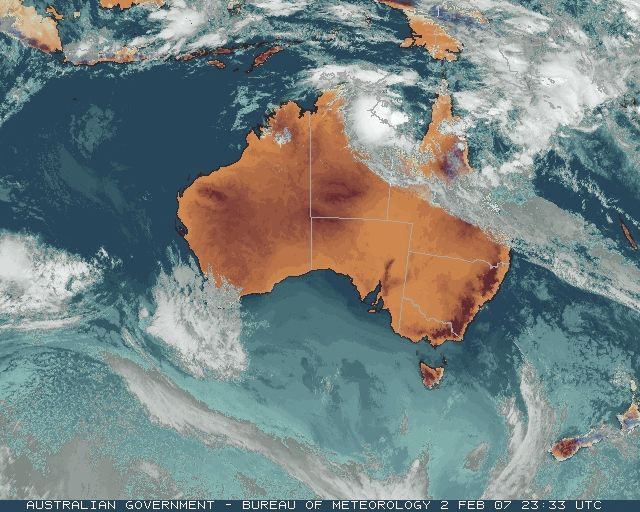
QLD: Flooding continues on the north and central coasts. Monsoonal activity continued to bring heavy rainfall to QLD's central, northern and gulf coasts today, though totals were generally less than yesterday. However, the development of a weak trough over the Northern Goldfields overnight saw Charters Towers break the one-day rainfall record it set yesterday, with 142.2mm in the gauge at 9am this morning, giving a 48-hour total of 274.2mm. Flooding in the Burdekin River closed the Flinders Highway between the city and Townsville. Heavy rain around Townsville finally eased off after 3 this morning after a 55mm downpour in 3 hours. The city's airport recorded 116.4mm to 9am, bringing its 4-day total to 477.0mm. Major flooding began to ease on the Haughton River, but Giru, 40km SE of Townsville and near the river's mouth, remained isolated by floodwaters and the main Bruce Highway cut. The highway north from Townsville to Cairns was reopened.

On the Central Coast, Mackay Airport recorded the highest 24-hour total of 136.4 to 9am, somewhat less than yesterday's total of 234.6mm. Flooding in the Pioneer Valley eased as rain diminished during today, but road and rail links to the north of the city remained closed. A woman had to be rescued from a car swept down a creek between Mackay and Nebo to the southwest.

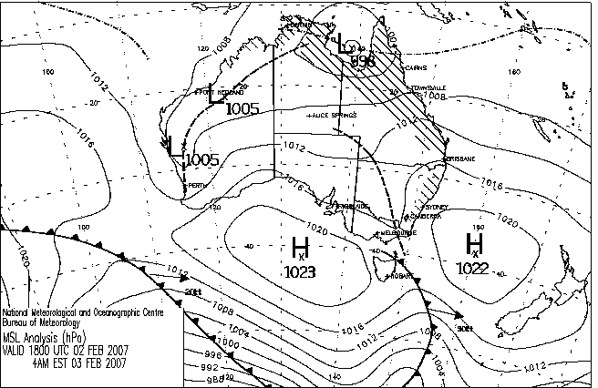
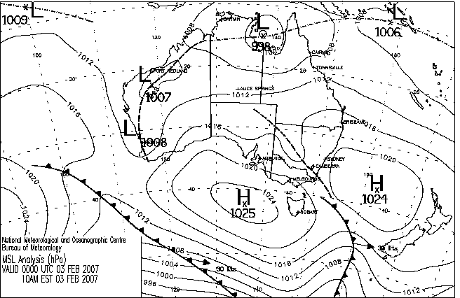
In the Gulf of Carpentaria, a 998hPa low moved very slowly into the SW corner of the Gulf, threatening to become a tropical cyclone and dumping heavy rain on the southern coast. Mornington Island recorded 181mm in the 24 hours to 9am, 87.8 of which fell between 9 and 11pm last night.

WA: Heatwave sets all-time records in the south. The heatwave that has beset southern WA reached new heights today, toppling all-time records at a dozen centres in the Central Wheat Belt and Great Southern districts. Cunderdin, Northam, Brookton, Corrigin, Lake Grace, Narembeen and Narrogin experienced their hottest day in over 40 years with Northam knocking a remarkable 2.3C off its previous all-time record. Top temperatures reached the mid to high 40s across an unusually large area of the state, with Hyden, Northam and Cunderdin topping 48C. See records and hottest for details. Maximum temperatures have been 10C or more above normal somewhere in southern WA every day for the past 10 days.


Records set or equalled today

These records are based on data received as at 0041 EST on 21/08/2008. Help in interpreting these statistics and information on quality control is here.

District Site Today Previous monthly record Previous all time record
if equalled or broken
Comments
Reading Reading Date Years Reading Date Years
Highest daily rainfall

QLD

Central Coast E

033017

DAYDREAM ISLAND RESORT

260.0

260.0

02/02/2007

15

260.0

02/02/2007

17

1 y Equal to record. Previous record set earlier this month.

QLD

Central Coast W

034084

CHARTERS TOWERS AIRPORT

142.2

132.0

02/02/2007

15

1 y Previous record set earlier this month.

Highest minimum temperature

WA

Murchison

007045

MEEKATHARRA AIRPORT

32.3

32.2

10/02/1956

57

1 Y

WA

Murchison

007600

MOUNT MAGNET AERO

32.3

30.7

01/02/1997

12

31.4

21/01/2006

13

1 Y

Highest maximum temperature

WA

Murchison

007139

PAYNES FIND

46.6

46.3

02/02/2007

27

46.5

20/01/1991

30

1 Y Previous record set earlier this month.

WA

E Gascoyne

007185

PARABURDOO AERO

46.4

46.1

17/02/2005

11

1 Y

WA

Central West

008039

DALWALLINU COMPARISON

46.0

45.7

13/02/1998

50

1 Y

WA

Central West

008137

WONGAN HILLS

47.0

45.1

27/02/1997

40

1 Y

WA

Cent Wheatbelt

010035

CUNDERDIN

48.0

47.8

23/02/1991

57

47.8

23/02/1991

58

1 Y

WA

Cent Wheatbelt

010073

KELLERBERRIN

47.5

45.8

01/02/1991

48

46.5

23/01/1980

49

1 Y

WA

Cent Wheatbelt

010111

NORTHAM

48.1

45.5

23/02/1991

42

45.8

23/01/1980

42

1 Y

WA

Cent Wheatbelt

010286

CUNDERDIN AIRFIELD

48.5

45.2

26/02/1997

11

45.7

03/01/1997

12

1 Y

WA

Cent Wheatbelt

010311

YORK

47.4

44.7

26/02/1997

11

45.7

22/01/2003

12

1 Y

WA

Gt Southern

010515

BEVERLEY

46.8

46.8

23/02/1991

37

46.8

23/02/1991

39

1 Y Equal to record.

WA

Gt Southern

010524

BROOKTON

46.2

45.0

23/02/1991

40

45.0

23/02/1991

41

1 Y

WA

Gt Southern

010536

CORRIGIN

46.5

45.2

01/02/1991

51

45.2

01/02/1991

51

1 Y

WA

Gt Southern

010568

HYDEN

48.6

48.2

01/02/1991

32

48.2

01/02/1991

37

1 Y

WA

Gt Southern

010592

LAKE GRACE COMPARISON

46.1

45.4

01/02/1991

44

45.4

01/02/1991

44

1 Y

WA

Gt Southern

010612

NAREMBEEN

47.1

45.6

01/02/1991

40

45.6

01/02/1991

42

1 Y

WA

Gt Southern

010614

NARROGIN

44.7

43.0

23/02/1991

41

43.4

04/01/1969

41

1 Y

WA

Gt Southern

010626

PINGELLY

46.2

44.0

23/02/1991

35

44.1

03/01/1997

37

1 Y

WA

Gt Southern

010692

NEWDEGATE RES.STATION

46.7

42.0

12/02/2004

11

42.8

27/12/2003

12

Y

WA

Goldfields

012038

KALGOORLIE-BOULDER AIRPORT

44.9

44.8

21/02/1998

66

1 Y


The day in charts
Surface charts Satellite images Rain & temperatures
4am EST Rainfall -- 24 hours to 9am
Available about 6am EST Available about 4am EST Available about 2pm EST
Week to 9am | SE AUS detail
10am EST Minimum temperature +/- normal
Available about noon EST Available about 10am EST Available about 2pm EST next day
Actual temperatures
4pm EST Maximum temperature +/- normal
Available about 6pm EST Available about 4pm EST Available about 2pm EST next day
Actual temperatures
10pm EST Solar Radiation
Available about midnight EST Available about 10pm EST Available about 2am EST next day

Summary of observations

For notes on how to interpret the data and quality control issues, see Daily Weather Summary Help.
**S** and **W** precede data flagged by the Bureau as suspicious or wrong
Data is as received at 00:02EST, 15/05/2012.

Major centres
Max
° C
+/- norm
° C
Min
° C
+/- norm
° C
Grass Min
° C
Rain to 9am mm Evaporation to 9am mm Sunshine hours Wind Run to 9am km (24-hour average km/h) Maximum Gust km/h / hour of occurrence
GERALDTON AIRPORT 30.2 -2.3 19.9 +0.8 18.2 0.0 7.0 -- 455 (19.0) 41/17
PERTH AIRPORT 42.3 +10.5 22.5 +5.1 25.7 0.0 10.8 11.5 421 (17.5) 48/15
ALBANY AIRPORT 27.5 +2.6 17.5 +3.1 15.4 0.0 8.0 2.7 624 (26.0) 48/11
BUNBURY 38.5 +8.7 21.3 +5.7 -- 0.0 -- -- 253 (10.5) 46/15
MANDURAH 35.5 -- 23.0 -- -- 0.0 -- -- 291 (12.1) 41/16
DARWIN AIRPORT 32.9 +1.5 23.8 -0.9 23.2 15.0 8.8 4.9 575 (24.0) 63/03
ALICE SPRINGS AIRPORT 36.2 +1.1 21.5 +0.7 19.2 0.0 13.2 12.3 434 (18.1) 68/12
WHYALLA AERO 35.9 +6.3 18.2 +0.5 -- 0.0 -- -- 286 (11.9) 43/17
ADELAIDE (KENT TOWN) 39.4 +10.1 19.3 +2.2 13.8 0.0 9.6 12.8 199 ( 8.3) 37/16
MOUNT GAMBIER AERO 28.1 +3.0 14.1 +2.5 9.6 0.0 4.4 13.2 368 (15.3) 41/14
MOUNT ISA AERO 27.0 -8.3 21.6 -1.8 20.8 4.0 6.4 0.9 652 (27.2) 58/00
CAIRNS AERO 30.5 -0.7 25.2 +1.5 23.9 18.6 5.6 3.7 263 (11.0) 41/14
TOWNSVILLE AERO 26.6 -4.5 23.7 -0.4 22.5 116.6 -- 0.0 492 (20.5) 46/18
MACKAY M.O 25.9 -3.7 20.7 -2.7 -- 138.8 -- 0.0 745 (31.0) 61/01
ROCKHAMPTON AERO 29.7 -1.6 20.0 -2.1 22.4 9.6 2.6 -- 340 (14.2) 43/13
BUNDABERG AERO 30.3 +0.4 21.7 +0.3 -- 7.0 1.8 -- 139 ( 5.8) --
NAMBOUR DPI 29.4 +0.6 21.2 +1.5 -- 27.4 -- -- 117 ( 4.9) 37/15
COOLANGATTA 30.1 +1.9 21.1 +0.3 -- 0.0 -- -- 475 (19.8) 44/14
BRISBANE AERO 28.9 -0.2 19.5 -1.6 17.9 9.8 5.8 12.3 428 (17.8) 41/13
TOOWOOMBA AIRPORT 29.3 +1.9 16.0 -1.6 -- 0.0 -- -- 578 (24.1) 55/15
GUNNEDAH RESOURCE CENTRE 36.2 +5.1 20.6 +2.0 14.6 0.0 9.0 -- 165 ( 6.9) --
COFFS HARBOUR MO 27.6 +0.8 16.6 -2.9 13.8 0.0 5.8 5.8 270 (11.3) 28/08
PORT MACQUARIE AIRPORT AWS 28.0 +0.5 13.2 -5.1 -- 0.0 -- -- -- --
WILLIAMTOWN RAAF 30.0 +2.5 16.3 -1.8 14.1 0.0 8.0 11.9 817 (34.0) 41/15
GOSFORD (NARARA RESEARCH STATION) AWS 27.8 +0.7 15.7 -1.4 -- 0.2 -- -- 119 ( 5.0) 28/14
ORANGE AGRICULTURAL INSTITUTE 31.2 +5.4 16.2 +3.1 12.3 0.4 4.6 11.3 -- --
DUBBO AIRPORT AWS 37.5 +5.5 21.6 +3.9 -- 0.0 -- -- -- --
SYDNEY AIRPORT AMO 28.1 +1.8 20.7 +1.7 17.8 0.0 7.6 12.4 602 (25.1) 50/14
RICHMOND RAAF 33.8 +4.8 17.8 +0.2 -- 0.0 -- -- 176 ( 7.3) 34/15
BELLAMBI AWS 25.5 +0.7 20.1 +1.0 -- 0.0 -- -- 438 (18.3) 44/12
CANBERRA AIRPORT 33.9 +6.8 16.5 +3.4 13.5 2.2 5.4 10.8 241 (10.0) 61/15
WAGGA WAGGA AMO 39.3 +8.4 19.4 +3.1 17.2 0.0 10.8 12.8 287 (12.0) 37/13
ALBURY AIRPORT AWS 39.7 +8.4 20.5 +4.4 -- 0.0 -- -- 96 ( 4.0) 39/18
MILDURA AIRPORT 39.9 +8.3 18.2 +1.8 15.3 0.0 10.4 13.1 214 ( 8.9) 32/16
TATURA INST SUSTAINABLE AG 36.7 +7.2 -- -- -- 0.0 -- -- -- 37/18
BENDIGO AIRPORT 38.3 +8.9 16.3 +2.2 -- 0.0 -- -- 279 (11.6) 44/14
MELBOURNE REGIONAL OFFICE 24.7 -1.1 17.6 +3.0 15.4 0.0 7.4 -- 91 ( 3.8) 21/14
GEELONG AIRPORT 21.8 -3.2 12.7 -0.7 -- 0.0 -- -- 225 ( 9.4) 43/16
BALLARAT AERODROME 32.3 +7.3 14.0 +2.6 -- 0.0 -- -- 349 (14.5) 41/12
LAUNCESTON (TI TREE BEND) 28.7 +4.3 12.9 +0.9 -- 0.0 -- -- 249 (10.4) 41/14
HOBART AIRPORT 18.3 -4.0 11.4 -0.6 8.8 0.0 8.4 7.8 367 (15.3) 41/12
Max
° C
+/- norm
° C
Min
° C
+/- norm
° C
Grass Min
° C
Rain to 9am mm Evaporation to 9am mm Sunshine hours Wind Run to 9am km Maximum Gust km/h / hour of occurrence
Hottest
Highest maximum temperature>Greatest variation above normal maximum Highest minimum temperatureGreatest variation above normal minimum

48.6 HYDEN Cent Wheatbelt WA
48.5 CUNDERDIN AIRFIELD Cent Wheatbelt WA
48.1 NORTHAM Cent Wheatbelt WA
48.0 CUNDERDIN Cent Wheatbelt WA
47.5 KELLERBERRIN Cent Wheatbelt WA

+16.5 : 46.7 NEWDEGATE RES.STATION Cent Wheatbelt WA
+16.3 : 46.8 LAKE GRACE Cent Wheatbelt WA
+15.8 : 48.6 HYDEN Cent Wheatbelt WA
+15.6 : 44.0 RAVENSTHORPE Cent Wheatbelt WA
+15.5 : 46.1 LAKE GRACE COMPARISON Cent Wheatbelt WA

32.3 MEEKATHARRA AIRPORT E Gascoyne WA
32.3 MOUNT MAGNET AERO E Gascoyne WA
30.1 WULUNGURRU N Plateau NT
30.0 PAYNES FIND E Gascoyne WA
29.8 YEELIRRIE Goldfields WA

+10.0 : 23.0 MOUNT LOFTY Adelaide/Lofty SA
+9.5 : 32.3 MOUNT MAGNET AERO E Gascoyne WA
+9.2 : 30.0 PAYNES FIND E Gascoyne WA
+8.6 : 32.3 MEEKATHARRA AIRPORT E Gascoyne WA
+8.6 : 29.8 YEELIRRIE Goldfields WA

Coldest
Lowest maximum temperatureGreatest variation below normal maximum Lowest minimum temperatureGreatest variation below normal minimum

15.2 MOUNT WELLINGTON Southeast TAS
15.7 MAATSUYKER ISLAND LIGHTHOUSE Southeast TAS
15.8 TASMAN ISLAND Southeast TAS
16.0 CAPE BRUNY LIGHTHOUSE Southeast TAS
16.8 HOBART (ELLERSLIE ROAD) Southeast TAS

-10.4 : 22.8 MORANBAH WATER TREATMENT PLANT Central Coast W QLD
-8.3 : 27.0 MOUNT ISA AERO Gulf Country QLD
-7.8 : 27.4 MCARTHUR RIVER MINE N Rivers NT
-7.4 : 25.3 CHARTERS TOWERS AIRPORT Central Coast W QLD
-7.1 : 26.0 CLERMONT SIRIUS ST Central Highlands QLD
-7.1 : 28.7 LONGREACH AERO Central West QLD

3.4 LIAWENEE Central Plateau TAS
5.0 COOMA VISITORS CENTRE Goulburn/Monaro NSW
5.5 MOUNT WELLINGTON Southeast TAS
5.7 LAKE ST CLAIR NATIONAL PARK Central Plateau TAS
6.2 TUNNACK FIRE STATION Southeast TAS

-5.8 : 20.3 MCCLUER ISLAND N Rivers NT
-5.5 : 5.0 COOMA VISITORS CENTRE Goulburn/Monaro NSW
-5.1 : 13.2 PORT MACQUARIE AIRPORT AWS MidNorth Coast S NSW
-4.2 : 17.6 MORANBAH WATER TREATMENT PLANT Central Coast W QLD
-4.1 : 17.0 CLERMONT SIRIUS ST Central Highlands QLD

Wettest
Sunniest & dullest
Windiest
Highest gusts
Todays highest rainfall totals for the 24 hours to 9am. It includes the top 5 totals nationally followed by all reported falls of 50mm or more.
Highest and lowest recordings of hours of sunshine for the 24 hours to midnight.
Highest wind run totals in kilometres for the 24 hours to 9am (average speed in brackets). All reported runs > =25km/h are shown.
Highest wind gusts in km/h for the 24 hours to midnight followed by the hour in which it occurred. All stations with gusts > 89km/h are shown.
260.0 DAYDREAM ISLAND RESORT Central Coast E QLD
181.0 MORNINGTON ISLAND Gulf Country QLD
170.0 MUTARNEE STORE N Coast--Herbert QLD
166.0 CARDWELL RANGE N Coast--Herbert QLD
165.4 OONOONBA N Coast--Herbert QLD

NORTHERN TERRITORY
N Rivers
126.0 NUMBULWAR
103.2 GROOTE EYLANDT AIRPORT AWS
91.8 ALYANGULA POLICE
86.8 MCCLUER ISLAND
70.0 BING BONG PORT
67.4 CENTRE ISLAND
56.0 BORROLOOLA

QUEENSLAND
Gulf Country
181.0 MORNINGTON ISLAND
94.0 BLACKBULL SIDING
75.2 WONDOOLA STATION
63.0 SWEERS ISLAND
59.4 ESMERALDA STATION
Upper Carpentaria
120.0 SOUTHWICK WEST STATION
119.0 LOW HOLM STATION
103.6 ELLENVALE STATION
101.0 LOLWORTH STATION
100.0 TOOMBA STUD
86.0 HOMESTEAD POST OFFICE
85.0 PENTLAND POST OFFICE
85.0 ABINGDON DOWNS STATION
83.0 MOUNT SURPRISE TOWNSHIP
71.5 CARGOON STATION
57.4 HILLGROVE STATION
54.5 OAK VALLEY STATION
51.0 EMU VALLEY STATION
N Coast--Barron
86.0 MT GARNET POST OFFICE
71.0 MT SOPHIA
67.0 HAPPY VALLEY
52.0 MOSSMAN CENTRAL MILL
N Coast--Herbert
170.0 MUTARNEE STORE
166.0 CARDWELL RANGE
165.4 OONOONBA
141.0 HAWKINS CREEK
135.0 HORSESHOE BAY
134.0 PALUMA IVY COTTAGE
129.0 YABULU QLD NICKEL
128.6 YABULU
116.6 TOWNSVILLE AERO
108.4 ALLINGHAM FORREST DRIVE
106.0 GAIRLOCH
100.0 INGHAM PUMP STATION AL
98.6 BEMERSIDE
96.4 UPPER STONE EXELBY
95.0 HALIFAX
93.6 PALM ISLAND WATER TREAT
91.4 MACKNADE SUGAR MILL
86.0 HALIFAX ALERT
79.0 CRAWFORDS LOOKOUT ALERT
72.4 INGHAM COMPOSITE
72.0 CORSIS ALERT
67.4 BAMBAROO
67.0 PEACOCK SIDING ALERT
60.6 INNISFAIL
56.0 ELPHINSTONE POCKET NO1
55.0 INNISFAIL WHARF ALERT
55.0 TUNG OIL ALERT
54.0 MICHAEL CREEK ALERT
52.2 HORSE SHOE BEND
51.5 CHRISTMAS CREEK STATION
51.2 DARADGEE
50.0 RUSSELL RIVER
Central Coast E
260.0 DAYDREAM ISLAND RESORT
140.8 MAJORS CREEK
138.8 MACKAY M.O
128.0 MACKAY ALERT
126.0 EAST MACKAY
116.0 GIRU NORTH
114.0 PLEYSTOWE SUGAR MILL
111.2 SHIRBOURNE PARK
105.5 LINDEMAN ISLAND RESORT
105.2 HAMILTON ISLAND AIRPORT
104.0 GIRU POST OFFICE
98.0 SEAFORTH
96.0 MACKAY AERO
96.0 DUMBLETON ROCKS ALERT
94.2 HAMILTON ISLAND AIRPORT
92.2 BRAMPTON ISLAND RESORT
88.0 FLORA VALLEY
87.0 OWENS CREEK
84.0 MOUNT JUKES
82.0 MOUNT CHARLTON
82.0 GARGETT POST OFFICE
79.0 DALRYMPLE HEIGHTS
76.0 PLANE CREEK SUGAR MILL
75.0 FLETCHER VIEW STATION
72.7 MINGELA POST OFFICE
69.4 MIRAMBEENA
66.0 ETON STATE WATER DEPOT
65.0 STOCKADE NURSERY
58.0 KOUMALA HATFIELDS ROAD
56.8 BOWEN CHEETHAM SALT
55.0 BOWEN AIRPORT
54.0 BLOOMSBURY
53.6 AYR DPI RESEARCH STN
52.0 MIRANI MARY STREET
51.6 PROSERPINE FULLER ST
51.0 HAYMAN ISLAND RESORT
Central Coast W
142.2 CHARTERS TOWERS AIRPORT
123.0 BALFES CREEK POST OFFICE
89.2 HOLMVALE
69.0 TRAFALGAR STATION
64.4 SELLHEIM
Central West
62.0 RONLOW PARK
59.4 SUMMER HILL
59.0 ABERFOYLE
51.0 LUTHRIE
Northwest
56.0 DAGWORTH STATION
Brisbane/SE Coast
72.0 BRIBIE ISLAND ALERT
64.0 BEERBURRUM FOREST STATION
54.0 MALENY DENNING RD
52.4 MALENY MARY CAIRNCROSS AVE

13.4 ADELAIDE AIRPORT Adelaide/Lofty SA
13.2 MOUNT GAMBIER AERO Lower SE SA
13.1 CEDUNA AMO W Agricultural SA
13.1 MILDURA AIRPORT Mallee N VIC
13.0 LIAWENEE Central Plateau TAS

.....

0.6 LARRIMAH N Rivers NT
0.2 KAIRI RESEARCH STATION N Coast--Barron QLD
0.0 TOWNSVILLE AERO N Coast--Herbert QLD
0.0 MACKAY M.O Central Coast E QLD
0.0 WARWICK Darling Downs E QLD

1053 (43.9) HAMILTON ISLAND AIRPORT Central Coast E QLD
991 (41.3) CAPE MORETON LIGHTHOUSE Brisbane/SE Coast QLD
969 (40.4) RUNDLE ISLAND Wide Bay/Burnett QLD
836 (34.8) JULIA CREEK AIRPORT Gulf Country QLD
821 (34.2) DOUBLE ISLAND POINT LIGHTHOUSE Brisbane/SE Coast QLD
821 (34.2) GOLD COAST SEAWAY Brisbane/SE Coast QLD
817 (34.0) WILLIAMTOWN RAAF Hunter Valley NSW
791 (33.0) LADY ELLIOT ISLAND Wide Bay/Burnett QLD
788 (32.8) CLONCURRY AIRPORT Gulf Country QLD
777 (32.4) HERON ISLAND RES STN Wide Bay/Burnett QLD
764 (31.8) RICHMOND AIRPORT Upper Carpentaria QLD
745 (31.0) MACKAY M.O Central Coast E QLD
741 (30.9) MONTAGUE ISLAND LIGHTHOUSE South Coast NSW
722 (30.1) CAPE GRIM BAPS N Coast TAS
718 (29.9) WINTON AIRPORT Northwest QLD
702 (29.3) CARNARVON AIRPORT W Gascoyne WA
692 (28.8) MCCLUER ISLAND N Rivers NT
691 (28.8) CAPE LEEUWIN Lower West WA
682 (28.4) COCONUT ISLAND N Peninsula QLD
682 (28.4) LORD HOWE ISLAND AERO Islands ISL
676 (28.2) MAATSUYKER ISLAND LIGHTHOUSE Southeast TAS
652 (27.2) MOUNT ISA AERO Gulf Country QLD
641 (26.7) TENNANT CREEK AIRPORT N Plateau NT
633 (26.4) BYRON BAY (CAPE BYRON AWS) North Coast NSW
624 (26.0) ALBANY AIRPORT Lower West WA
621 (25.9) ALVA BEACH Central Coast E QLD
617 (25.7) TASMAN ISLAND Southeast TAS
607 (25.3) POINT FAWCETT Islands ISL
602 (25.1) SYDNEY AIRPORT AMO Sydney--east NSW
83/13 LAKE GRACE Cent Wheatbelt WA
78/23 BROOME AIRPORT W Kimberley WA
74/20 LUCINDA POINT N Coast--Herbert QLD
71/22 HAMILTON ISLAND AIRPORT Central Coast E QLD
70/18 NARRABRI AIRPORT AWS NW Slopes N NSW

Downpours High AWS wind reports
High rainfall for periods of 6 hours or less from AWS and synoptic reports. Storm force gusts (>89km/h) and 10-minute mean gales (>62km/h) reported by AWSs. Wind direction and mean windspeed are shown in brackets.
WESTERN AUSTRALIA
W Kimberley
DERBY AERO
4.8mm in 3 min to 19:41 96.0mm/h
4.2mm in 3 min to 19:44 84.0mm/h
10.8mm in 1 hr to 20:00 10.8mm/h
NORTHERN TERRITORY
N Rivers
DARWIN AIRPORT
5.6mm in 15 min to 03:55 22.4mm/h
10.4mm in 1 hr to 04:00 10.4mm/h
DARWIN AIRPORT COMPARISON
16.0mm in 3 hr to 06:30 5.3mm/h
MIDDLE POINT AWS
16.0mm in 3 hr to 18:30 5.3mm/h
PIRLANGIMPI
10.2mm in 1 hr to 08:30 10.2mm/h
26.0mm in 3 hr to 09:30 8.7mm/h
POINT STUART AWS
20.0mm in 3 hr to 16:00 6.7mm/h
17.0mm in 3 hr to 17:00 5.7mm/h
16.0mm in 3 hr to 18:00 5.3mm/h
ALYANGULA POLICE
61.0mm in 3 hr to 09:30 20.3mm/h
NGAYAWILI
20.0mm in 3 hr to 03:30 6.7mm/h
GROOTE EYLANDT AIRPORT AWS
21.6mm in 1 hr to 00:30 21.6mm/h
35.0mm in 3 hr to 00:30 11.7mm/h
15.2mm in 1 hr to 18:30 15.2mm/h
22.0mm in 3 hr to 18:30 7.3mm/h
CENTRE ISLAND
11.8mm in 25 min to 03:55 28.3mm/h
15.4mm in 1 hr to 04:30 15.4mm/h
25.0mm in 3 hr to 06:30 8.3mm/h
17.6mm in 1 hr to 08:30 17.6mm/h
29.0mm in 3 hr to 09:30 9.7mm/h
MCARTHUR RIVER MINE
10.0mm in 1 hr to 05:30 10.0mm/h
10.0mm in 1 hr to 11:30 10.0mm/h
21.0mm in 3 hr to 12:30 7.0mm/h
20.0mm in 3 hr to 21:30 6.7mm/h
BORROLOOLA
16.0mm in 3 hr to 06:30 5.3mm/h
15.2mm in 1 hr to 07:30 15.2mm/h
26.0mm in 3 hr to 09:30 8.7mm/h
18.0mm in 3 hr to 12:30 6.0mm/h
DOUGLAS RIVER
4.0mm in 3 min to 22:00 80.0mm/h
10.8mm in 7 min to 22:07 92.6mm/h
23.0mm in 1 hr to 22:30 23.0mm/h
QUEENSLAND
N Peninsula
COEN AIRPORT
15.6mm in 31 min to 14:54 30.2mm/h
17.6mm in 1 hr to 15:00 17.6mm/h
18.0mm in 3 hr to 15:00 6.0mm/h
SCHERGER RAAF
10.2mm in 1 hr to 22:00 10.2mm/h
Gulf Country
MORNINGTON ISLAND
96.0mm in 3 hr to 00:00 32.0mm/h
24.2mm in 1 hr to 03:30 24.2mm/h
10.6mm in 30 min to 05:00 21.2mm/h
17.4mm in 1 hr to 05:00 17.4mm/h
16.2mm in 1 hr to 05:30 16.2mm/h
31.0mm in 3 hr to 06:00 10.3mm/h
NORMANTON AIRPORT
12.0mm in 1 hr to 04:00 12.0mm/h
16.0mm in 3 hr to 06:00 5.3mm/h
11.0mm in 1 hr to 16:00 11.0mm/h
16.0mm in 3 hr to 18:00 5.3mm/h
BURKETOWN AIRPORT
12.0mm in 1 hr to 01:00 12.0mm/h
21.0mm in 3 hr to 03:00 7.0mm/h
24.6mm in 1 hr to 22:00 24.6mm/h
N Coast--Barron
CAIRNS AERO
13.4mm in 1 hr to 03:30 13.4mm/h
LOW ISLES LIGHTHOUSE
3.0mm in 2 min to 10:19 90.0mm/h
8.6mm in 37 min to 10:56 13.9mm/h
12.4mm in 1 hr to 11:00 12.4mm/h
N Coast--Herbert
TOWNSVILLE AERO
22.0mm in 3 hr to 00:00 7.3mm/h
19.6mm in 30 min to 00:30 39.2mm/h
25.2mm in 1 hr to 00:30 25.2mm/h
15.6mm in 30 min to 01:00 31.2mm/h
35.2mm in 1 hr to 01:00 35.2mm/h
25.0mm in 1 hr to 01:30 25.0mm/h
14.8mm in 1 hr to 02:00 14.8mm/h
55.0mm in 3 hr to 03:00 18.3mm/h
LUCINDA POINT
18.0mm in 3 hr to 00:00 6.0mm/h
Central Coast E
AYR DPI RESEARCH STN
25.0mm in 3 hr to 00:00 8.3mm/h
MACKAY AERO
19.0mm in 3 hr to 00:00 6.3mm/h
HAMILTON ISLAND AIRPORT
22.2mm in 43 min to 04:43 31.0mm/h
17.2mm in 17 min to 05:00 60.7mm/h
39.4mm in 1 hr to 05:00 39.4mm/h
15.8mm in 52 min to 05:52 18.2mm/h
18.0mm in 1 hr to 06:00 18.0mm/h
66.0mm in 3 hr to 06:00 22.0mm/h
24.0mm in 3 hr to 09:00 8.0mm/h
12.4mm in 1 hr to 10:00 12.4mm/h
14.0mm in 37 min to 10:37 22.7mm/h
40.0mm in 3 hr to 12:00 13.3mm/h
MACKAY M.O
21.0mm in 3 hr to 00:00 7.0mm/h
Brisbane/SE Coast
BEERBURRUM FOREST STATION
14.2mm in 1 hr to 00:00 14.2mm/h
14.0mm in 1 hr to 00:30 14.0mm/h
10.6mm in 30 min to 01:30 21.2mm/h
13.6mm in 1 hr to 01:30 13.6mm/h
14.4mm in 1 hr to 02:00 14.4mm/h
27.0mm in 3 hr to 03:00 9.0mm/h
NEW SOUTH WALES
C Tablelands N
NULLO MOUNTAIN AWS
6.8mm in 38 min to 16:00 10.7mm/h
11.4mm in 1 hr to 16:00 11.4mm/h

WESTERN AUSTRALIA
Lower West
BADGINGARRA RESEARCH STN : 70(360/ 65 ) at 10:49