|
For notes on how to interpret
the data and quality control issues, see Daily Weather Summary Help.
**S** and **W** precede data flagged by the Bureau as suspicious or wrong
Data is as received at 00:42EST, 15/05/2012.
|
|
| |
Max
°
C |
+/- norm
°
C |
Min
°
C |
+/- norm
°
C |
Grass Min
°
C |
Rain to 9am mm |
Evaporation to 9am mm |
Sunshine hours |
Wind Run to 9am km (24-hour average km/h) |
Maximum Gust km/h / hour of occurrence |
| GERALDTON AIRPORT |
25.8 |
+4.9 |
15.6 |
+4.6 |
16.5 |
0.0 |
9.4 |
-- |
581 (24.2) |
68/11 |
| PERTH AIRPORT |
18.5 |
-0.4 |
11.1 |
+2.1 |
5.6 |
0.0 |
4.8 |
0.3 |
695 (29.0) |
54/22 |
| ALBANY AIRPORT |
17.9 |
+1.3 |
7.4 |
-0.7 |
5.4 |
0.0 |
1.4 |
7.5 |
507 (21.1) |
45/13 |
| BUNBURY |
18.6 |
+0.2 |
12.7 |
+4.6 |
-- |
0.0 |
-- |
-- |
500 (20.8) |
52/21 |
| MANDURAH |
18.1 |
-- |
13.3 |
-- |
-- |
0.0 |
-- |
-- |
629 (26.2) |
61/20 |
| DARWIN AIRPORT |
33.9 |
+3.3 |
23.5 |
+3.6 |
22.7 |
0.0 |
7.4 |
10.9 |
-- |
41/09 |
| ALICE SPRINGS AIRPORT |
18.0 |
-1.8 |
0.8 |
-4.3 |
-2.1 |
0.0 |
5.6 |
10.0 |
310 (12.9) |
41/14 |
| WHYALLA AERO |
14.8 |
-2.5 |
8.3 |
+2.2 |
-- |
0.0 |
4.0 |
-- |
213 ( 8.9) |
37/23 |
| ADELAIDE (KENT TOWN) |
13.1 |
-3.0 |
6.9 |
-1.2 |
-- |
0.0 |
0.4 |
1.6 |
107 ( 4.5) |
24/23 |
| MOUNT GAMBIER AERO |
15.0 |
+1.2 |
8.1 |
+2.3 |
6.0 |
0.6 |
0.6 |
6.5 |
197 ( 8.2) |
35/15 |
| MOUNT ISA AERO |
19.4 |
-5.5 |
10.6 |
+0.6 |
10.8 |
12.6 |
4.0 |
0.7 |
414 (17.3) |
41/16 |
| CAIRNS AERO |
29.3 |
+3.3 |
23.2 |
+5.4 |
21.8 |
0.2 |
2.4 |
4.8 |
376 (15.7) |
37/23 |
| TOWNSVILLE AERO |
24.7 |
-0.9 |
21.9 |
+7.3 |
21.2 |
0.0 |
4.2 |
0.0 |
323 (13.5) |
45/14 |
| MACKAY M.O |
20.6 |
-1.3 |
18.4 |
+4.4 |
-- |
21.0 |
-- |
0.0 |
481 (20.0) |
58/11 |
| ROCKHAMPTON AERO |
19.4 |
-4.1 |
17.7 |
+6.8 |
17.3 |
14.2 |
1.8 |
-- |
284 (11.8) |
32/00 |
| BUNDABERG AERO |
20.3 |
-2.3 |
18.3 |
+6.7 |
-- |
31.1 |
2.1 |
-- |
284 (11.8) |
30/15 |
| NAMBOUR DPI |
18.6 |
-3.0 |
16.2 |
+6.9 |
-- |
43.8 |
2.6 |
-- |
51 ( 2.1) |
17/13 |
| COOLANGATTA |
17.7 |
-3.4 |
16.2 |
+4.7 |
-- |
20.0 |
-- |
-- |
219 ( 9.1) |
28/08 |
| BRISBANE AERO |
18.9 |
-2.4 |
16.4 |
+5.9 |
15.9 |
34.0 |
2.2 |
0.0 |
304 (12.7) |
46/05 |
| TOOWOOMBA AIRPORT |
14.1 |
-2.9 |
12.6 |
+5.1 |
-- |
14.4 |
-- |
-- |
627 (26.1) |
55/06 |
| GUNNEDAH RESOURCE CENTRE |
-- |
-- |
7.3 |
+1.2 |
5.2 |
0.0 |
0.9 |
-- |
92 ( 3.8) |
-- |
| COFFS HARBOUR MO |
17.7 |
-1.7 |
13.7 |
+4.6 |
11.3 |
3.0 |
2.0 |
0.0 |
268 (11.2) |
34/22 |
| PORT MACQUARIE AIRPORT AWS |
19.3 |
-0.2 |
12.3 |
+4.3 |
-- |
0.0 |
-- |
-- |
-- |
-- |
| WILLIAMTOWN RAAF |
18.0 |
+0.4 |
7.6 |
-0.3 |
4.6 |
0.0 |
1.2 |
4.2 |
265 (11.0) |
21/14 |
| GOSFORD (NARARA RESEARCH STATION) AWS |
19.0 |
+1.1 |
7.2 |
+0.7 |
-- |
0.2 |
-- |
-- |
84 ( 3.5) |
13/11 |
| ORANGE AGRICULTURAL INSTITUTE |
12.0 |
+1.5 |
3.1 |
+0.5 |
-7.0 |
0.4 |
2.6 |
2.0 |
-- |
-- |
| DUBBO AIRPORT AWS |
17.0 |
+0.6 |
6.0 |
+1.4 |
-- |
0.0 |
-- |
-- |
-- |
-- |
| SYDNEY AIRPORT AMO |
17.6 |
0.0 |
8.9 |
+0.4 |
6.3 |
0.0 |
2.2 |
4.9 |
449 (18.7) |
26/14 |
| RICHMOND RAAF |
16.1 |
-1.9 |
3.1 |
-1.8 |
-- |
0.0 |
-- |
-- |
45 ( 1.9) |
13/18 |
| BELLAMBI AWS |
17.1 |
-0.6 |
11.8 |
+0.8 |
-- |
0.0 |
-- |
-- |
341 (14.2) |
50/05 |
| CANBERRA AIRPORT |
13.6 |
+1.4 |
1.6 |
+0.6 |
-1.7 |
0.0 |
0.2 |
8.0 |
167 ( 7.0) |
15/05 |
| WAGGA WAGGA AMO |
15.6 |
+1.8 |
3.4 |
-0.3 |
1.1 |
0.0 |
1.2 |
9.3 |
156 ( 6.5) |
21/09 |
| ALBURY AIRPORT AWS |
15.2 |
+1.0 |
2.1 |
-1.8 |
-- |
0.0 |
-- |
-- |
56 ( 2.3) |
13/16 |
| MILDURA AIRPORT |
14.5 |
-1.5 |
1.5 |
-3.7 |
-1.0 |
0.0 |
1.0 |
8.3 |
199 ( 8.3) |
32/14 |
| TATURA INST SUSTAINABLE AG |
14.6 |
+0.6 |
-0.7 |
-4.4 |
-- |
0.0 |
0.6 |
-- |
173 ( 7.2) |
18/13 |
| BENDIGO AIRPORT |
14.3 |
+1.1 |
1.0 |
-2.6 |
-- |
0.2 |
-- |
-- |
214 ( 8.9) |
�
24/19 |
| MELBOURNE REGIONAL OFFICE |
15.4 |
+1.4 |
6.8 |
-0.1 |
7.4 |
0.2 |
0.6 |
-- |
45 ( 1.9) |
18/15 |
| GEELONG AIRPORT |
15.0 |
+0.4 |
9.2 |
+2.9 |
-- |
1.2 |
-- |
-- |
200 ( 8.3) |
34/23 |
| BALLARAT AERODROME |
11.9 |
+1.1 |
5.7 |
+1.7 |
-- |
0.6 |
-- |
-- |
345 (14.4) |
34/22 |
| LAUNCESTON (TI TREE BEND) |
13.7 |
+0.6 |
-0.8 |
-3.7 |
-- |
0.0 |
-- |
-- |
40 ( 1.7) |
35/23 |
| HOBART AIRPORT |
16.1 |
+3.2 |
4.4 |
-0.2 |
-0.1 |
0.0 |
2.2 |
6.4 |
429 (17.9) |
52/18 |
| |
Max
°
C |
+/- norm
°
C |
Min
°
C |
+/- norm
°
C |
Grass Min
°
C |
Rain to 9am mm |
Evaporation to 9am mm |
Sunshine hours |
Wind Run to 9am km |
Maximum Gust km/h / hour of occurrence |
|
| Hottest |
| Highest maximum temperature> | Greatest variation above normal maximum |
Highest minimum temperature | Greatest variation above normal minimum |
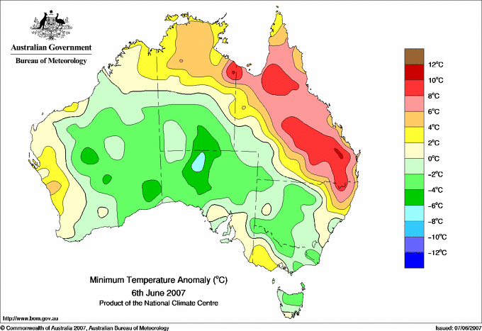
34.7 JABIRU AIRPORT N Rivers NT
34.6 MIDDLE POINT AWS N Rivers NT
34.0 OENPELLI N Rivers NT
33.9 DARWIN AIRPORT N Rivers NT
33.8 DARWIN AIRPORT COMPARISON N Rivers NT
33.8 BATCHELOR AERO N Rivers NT
|
+5.3 : 26.0 ENEABBA Central West WA
+4.9 : 25.8 GERALDTON AIRPORT Central West WA
+4.6 : 19.1 BICHENO (COUNCIL DEPOT) E Coast TAS
+4.3 : 17.0 FINGAL (LEGGE STREET) E Coast TAS
+4.1 : 24.0 MULLEWA Central West WA
+4.1 : 26.9 KALBARRI Central West WA
+4.1 : 24.6 JURIEN BAY Lower West WA
|
26.5 HORN ISLAND N Peninsula QLD
26.2 COCONUT ISLAND N Peninsula QLD
26.0 CAPE DON N Rivers NT
26.0 TROUGHTON ISLAND N Kimberley WA
25.8 COCOS ISLAND AIRPORT Islands ISL
|
+10.6 : 14.7 OAKEY AERO Darling Downs E QLD
+10.3 : 17.6 THANGOOL AIRPORT Wide Bay/Burnett QLD
+10.3 : 17.0 MONTO TOWNSHIP Wide Bay/Burnett QLD
+9.9 : 9.9 GLEN INNES AIRPORT AWS N Tablelands W NSW
+9.7 : 17.2 GAYNDAH POST OFFICE Wide Bay/Burnett QLD
|
| Coldest |
| Lowest maximum temperature | Greatest variation below normal maximum |
Lowest minimum temperature | Greatest variation below normal minimum |
2.3 MT HOTHAM Upper NE VIC
3.0 PERISHER VALLEY SKI CENTRE Snowy Mtns NSW
3.8 MOUNT READ W Coast TAS
4.0 THREDBO AWS Snowy Mtns NSW
4.0 GRAMPIANS (MOUNT WILLIAM) Wimmera S VIC
|
-10.1 : 16.0 TOORAK RESEARCH STATION Gulf Country QLD
-8.3 : 18.1 CLONCURRY AIRPORT Gulf Country QLD
-7.8 : 18.3 RICHMOND POST OFFICE Upper Carpentaria QLD
-7.7 : 18.9 RICHMOND AIRPORT Upper Carpentaria QLD
-7.0 : 12.3 MUNGINDI POST OFFICE NW Plains W NSW
|
-8.2 THREDBO AWS Snowy Mtns NSW
-7.8 CHARLOTTE PASS (KOSCIUSKO CHALET) Snowy Mtns NSW
-7.0 THREDBO VILLAGE Snowy Mtns NSW
-6.5 PERISHER VALLEY SKI CENTRE Snowy Mtns NSW
-6.2 COOMA AIRPORT AWS Goulburn/Monaro NSW
|
-9.9 : -3.0 EYRE Eucla WA
-6.6 : -1.0 MARLA POLICE STATION NW Pastoral SA
-6.3 : -1.5 COBAR AIRPORT AWS Upper Darling NSW
-5.7 : -0.2 KULGERA N Plateau NT
-5.6 : -6.2 COOMA AIRPORT AWS Goulburn/Monaro NSW
|
|
Sunniest &
dullest |
Windiest |
Highest gusts |
Todays highest rainfall totals for the 24 hours to 9am. It
includes the top 5 totals nationally followed by all reported falls of 50mm or more. |
Highest
and lowest recordings of hours of sunshine for the 24 hours to midnight. |
Highest wind
run totals in kilometres for the 24 hours to 9am (average speed in brackets).
All reported runs >
=25km/h are shown. |
Highest wind
gusts in km/h for the 24 hours to midnight followed by the hour in which it occurred.
All stations with gusts >
89km/h are shown. |
102.0 ORMISTON COLLEGE Brisbane/SE Coast QLD
98.5 POINT LOOKOUT Brisbane/SE Coast QLD
83.5 WARRA JINGHI JINGHI Darling Downs E QLD
80.6 POINT ARKWRIGHT Brisbane/SE Coast QLD
80.0 COOMERA FOXWELL ROAD Brisbane/SE Coast QLD
QUEENSLAND
Central Coast E
64.8 BRAMPTON ISLAND RESORT
Central Coast W
62.2 MT DOUGLAS
Wide Bay/Burnett
58.0 GOOMINGLAH
Brisbane/SE Coast
102.0 ORMISTON COLLEGE
98.5 POINT LOOKOUT
80.6 POINT ARKWRIGHT
80.0 COOMERA FOXWELL ROAD
70.8 BLI BLI
68.0 CANNON HILLS BOWLS CLUB
65.8 GOLD COAST SEAWAY
59.6 SOMERSET DAM
58.9 MOORINA
58.0 CALOUNDRA WTP
55.0 COURAN COVE
54.2 LANDSBOROUGH POST OFFICE
54.0 MAROOCHYDORE AERO
53.4 REDLANDS HRS
53.0 MT BRISBANE
52.6 BRISBANE
52.6 CLONTARF
52.0 DECEPTION BAY ALERT
52.0 COOMBABAH WATER TREATMENT PLANT
51.5 KUMBIA POST OFFICE
51.2 RUDDS LANE TM
50.8 BRISBANE BOTANIC GARDENS MT COOT-THA
50.6 HILLTOP GARDENS
50.0 KARALEE
50.0 TOOWONG BOWLS CLUB
50.0 MANGO HILL
Darling Downs E
83.5 WARRA JINGHI JINGHI
80.0 KIA ORA
79.6 EHLMA PARK
77.0 FERNFLAT
70.0 DALBY POWER STATION
66.0 PASSCHENDAELE
61.0 BRIGALOW BRIDGE TM
58.2 BOXDALE
54.8 GLENELG
53.4 JANDOWAE POST OFFICE
51.8 OAKLEIGH
51.0 JINGI JINGI
50.0 THE RANCH
Darling Downs W
68.6 DUNGADEN
53.0 HAREWOOD
52.0 WOODLEA
Maranoa
58.6 YULEBA GORDON ST
53.6 SOMERSET
NEW SOUTH WALES
N Tablelands W
52.8 TENTERFIELD (SANDY HILL (BOOROOK))
|
10.9 DARWIN AIRPORT N Rivers NT
10.7 BROOME AIRPORT W Kimberley WA
10.7 RABBIT FLAT N Plateau NT
10.4 GILES METEOROLOGICAL OFFICE Interior WA
10.2 TENNANT CREEK AIRPORT N Plateau NT
.....
0.0 TOWNSVILLE AERO N Coast--Herbert QLD
0.0 MACKAY M.O Central Coast E QLD
0.0 BRISBANE AERO Brisbane/SE Coast QLD
0.0 WARWICK Darling Downs E QLD
0.0 INVERELL RESEARCH CENTRE N Tablelands W NSW
0.0 COFFS HARBOUR MO MidNorth Coast N NSW
0.0 BRIAN PASTURES Brisbane/SE Coast QLD
0.0 ALSTONVILLE TROPICAL FRUIT RESEARCH STAT North Coast NSW
|
1338 (55.8) MOUNT WELLINGTON Southeast TAS
1250 (52.1) HARTZ MOUNTAIN (KEOGHS PIMPLE) Southeast TAS
1187 (49.5) MAATSUYKER ISLAND LIGHTHOUSE Southeast TAS
980 (40.8) MOUNT READ W Coast TAS
897 (37.4) ROTTNEST ISLAND Lower West WA
890 (37.1) CAPE NATURALISTE Lower West WA
854 (35.6) CAPE GRIM BAPS N Coast TAS
818 (34.1) VARANUS ISLAND Islands ISL
805 (33.5) PEARCE RAAF Lower West WA
733 (30.5) CAPE LEEUWIN Lower West WA
714 (29.8) WILLIS ISLAND Islands ISL
695 (29.0) PERTH AIRPORT Lower West WA
691 (28.8) MCCLUER ISLAND N Rivers NT
686 (28.6) CAPE MORETON LIGHTHOUSE Brisbane/SE Coast QLD
683 (28.5) GINGIN AERO Lower West WA
652 (27.2) BARROW ISLAND AIRPORT W Pilbara WA
648 (27.0) RUNDLE ISLAND Wide Bay/Burnett QLD
629 (26.2) MANDURAH Lower West WA
627 (26.1) TOOWOOMBA AIRPORT Darling Downs E QLD
619 (25.8) DALWALLINU Central West WA
608 (25.3) GARDEN ISLAND HSF Lower West WA
608 (25.3) CAPE BRUNY (CAPE BRUNY) Southeast TAS
|
98/11 MAATSUYKER ISLAND LIGHTHOUSE Southeast TAS
98/12 MOUNT WELLINGTON Southeast TAS
89/17 WILSONS PROMONTORY LIGHTHOUSE W Gippsland VIC
87/16 TASMAN ISLAND Southeast TAS
87/10 HARTZ MOUNTAIN (KEOGHS PIMPLE) Southeast TAS
|
�