|
For notes on how to interpret
the data and quality control issues, see Daily Weather Summary Help.
**S** and **W** precede data flagged by the Bureau as suspicious or wrong
Data is as received at 00:45EST, 15/05/2012.
|
|
| |
Max
°
C |
+/- norm
°
C |
Min
°
C |
+/- norm
°
C |
Grass Min
°
C |
Rain to 9am mm |
Evaporation to 9am mm |
Sunshine hours |
Wind Run to 9am km (24-hour average km/h) |
Maximum Gust km/h / hour of occurrence |
| GERALDTON AIRPORT |
19.8 |
-1.1 |
12.7 |
+1.7 |
9.8 |
2.6 |
3.8 |
-- |
395 (16.5) |
30/13 |
| PERTH AIRPORT |
20.4 |
+1.5 |
11.2 |
+2.2 |
9.6 |
2.2 |
0.2 |
6.9 |
165 ( 6.9) |
-- |
| ALBANY AIRPORT |
17.1 |
+0.5 |
11.1 |
+3.0 |
7.2 |
2.0 |
2.0 |
3.8 |
291 (12.1) |
26/10 |
| BUNBURY |
19.8 |
+1.4 |
7.9 |
-0.2 |
-- |
19.8 |
-- |
-- |
177 ( 7.4) |
21/00 |
| MANDURAH |
19.4 |
-- |
12.4 |
-- |
-- |
17.2 |
-- |
-- |
282 (11.8) |
26/15 |
| DARWIN AIRPORT |
32.0 |
+1.4 |
20.6 |
+0.7 |
19.3 |
0.0 |
10.0 |
10.2 |
442 (18.4) |
35/09 |
| ALICE SPRINGS AIRPORT |
13.5 |
-6.3 |
0.0 |
-5.1 |
-3.3 |
0.0 |
3.8 |
10.4 |
341 (14.2) |
41/11 |
| WHYALLA AERO |
12.8 |
-4.5 |
0.1 |
-6.0 |
-- |
0.0 |
6.0 |
-- |
196 ( 8.2) |
26/11 |
| ADELAIDE (KENT TOWN) |
13.7 |
-2.4 |
3.9 |
-4.2 |
-- |
0.0 |
0.2 |
9.3 |
135 ( 5.6) |
22/10 |
| MOUNT GAMBIER AERO |
13.3 |
-0.5 |
6.3 |
+0.5 |
3.9 |
0.2 |
1.0 |
8.3 |
241 (10.0) |
26/12 |
| MOUNT ISA AERO |
22.5 |
-2.4 |
9.5 |
-0.5 |
5.0 |
0.0 |
5.4 |
10.4 |
357 (14.9) |
37/11 |
| CAIRNS AERO |
24.5 |
-1.5 |
21.5 |
+3.7 |
20.0 |
0.0 |
3.6 |
0.2 |
600 (25.0) |
46/02 |
| TOWNSVILLE AERO |
20.2 |
-5.4 |
18.7 |
+4.1 |
18.0 |
0.0 |
5.8 |
0.0 |
376 (15.7) |
50/11 |
| MACKAY M.O |
18.1 |
-3.8 |
15.0 |
+1.0 |
-- |
0.0 |
-- |
0.0 |
533 (22.2) |
41/08 |
| ROCKHAMPTON AERO |
22.1 |
-1.4 |
11.1 |
+0.2 |
8.7 |
0.0 |
3.2 |
-- |
189 ( 7.9) |
18/14 |
| BUNDABERG AERO |
21.4 |
-1.2 |
10.8 |
-0.8 |
-- |
0.0 |
2.6 |
-- |
297 (12.4) |
31/14 |
| NAMBOUR DPI |
18.8 |
-2.8 |
8.2 |
-1.1 |
-- |
0.0 |
3.2 |
-- |
56 ( 2.3) |
21/10 |
| COOLANGATTA |
20.7 |
-0.4 |
7.1 |
-4.4 |
-- |
0.0 |
-- |
-- |
228 ( 9.5) |
35/15 |
| BRISBANE AERO |
20.1 |
-1.2 |
7.0 |
-3.5 |
4.0 |
0.0 |
4.6 |
6.6 |
285 (11.9) |
28/15 |
| TOOWOOMBA AIRPORT |
16.1 |
-0.9 |
1.7 |
-5.8 |
-- |
0.0 |
-- |
-- |
326 (13.6) |
28/08 |
| GUNNEDAH RESOURCE CENTRE |
-- |
-- |
1.2 |
-4.9 |
-1.9 |
0.0 |
1.8 |
-- |
129 ( 5.4) |
-- |
| COFFS HARBOUR MO |
16.6 |
-2.8 |
8.5 |
-0.6 |
5.0 |
0.0 |
2.2 |
5.5 |
139 ( 5.8) |
-- |
| PORT MACQUARIE AIRPORT AWS |
15.7 |
-3.8 |
3.5 |
-4.5 |
-- |
0.0 |
-- |
-- |
-- |
-- |
| WILLIAMTOWN RAAF |
16.1 |
-1.5 |
5.1 |
-2.8 |
1.7 |
0.0 |
2.6 |
9.6 |
389 (16.2) |
32/08 |
| GOSFORD (NARARA RESEARCH STATION) AWS |
15.0 |
-2.9 |
-- |
-- |
-- |
0.0 |
-- |
-- |
169 ( 7.0) |
-- |
| ORANGE AGRICULTURAL INSTITUTE |
8.0 |
-2.5 |
-2.0 |
-4.6 |
-5.0 |
0.0 |
1.0 |
1.3 |
-- |
-- |
| DUBBO AIRPORT AWS |
12.0 |
-4.4 |
-0.3 |
-4.9 |
-- |
0.0 |
-- |
-- |
-- |
-- |
| SYDNEY AIRPORT AMO |
15.3 |
-2.3 |
6.5 |
-2.0 |
3.5 |
0.0 |
3.4 |
3.5 |
564 (23.5) |
54/18 |
| RICHMOND RAAF |
12.9 |
-5.1 |
0.5 |
-4.4 |
-- |
0.0 |
-- |
-- |
91 ( 3.8) |
43/11 |
| BELLAMBI AWS |
15.9 |
-1.8 |
8.7 |
-2.3 |
-- |
4.8 |
-- |
-- |
440 (18.3) |
78/19 |
| CANBERRA AIRPORT |
10.7 |
-1.5 |
-0.4 |
-1.4 |
-3.3 |
4.6 |
1.6 |
4.6 |
317 (13.2) |
48/05 |
| WAGGA WAGGA AMO |
13.0 |
-0.8 |
-2.5 |
-6.2 |
-3.8 |
0.0 |
0.4 |
2.6 |
244 (10.2) |
28/15 |
| ALBURY AIRPORT AWS |
14.1 |
-0.1 |
-1.5 |
-5.4 |
-- |
0.0 |
-- |
-- |
74 ( 3.1) |
43/18 |
| MILDURA AIRPORT |
12.8 |
-3.2 |
1.3 |
-3.9 |
-0.8 |
0.0 |
1.0 |
9.6 |
276 (11.5) |
32/10 |
| TATURA INST SUSTAINABLE AG |
13.3 |
-0.7 |
2.1 |
-1.6 |
-- |
0.0 |
2.0 |
-- |
382 (15.9) |
34/10 |
| BENDIGO AIRPORT |
11.8 |
-1.4 |
1.9 |
-1.7 |
-- |
0.0 |
-- |
-- |
325 (13.5) |
�
37/11 |
| MELBOURNE REGIONAL OFFICE |
13.8 |
-0.2 |
3.0 |
-3.9 |
0.5 |
0.8 |
1.4 |
-- |
113 ( 4.7) |
26/12 |
| GEELONG AIRPORT |
12.8 |
-1.8 |
4.6 |
-1.7 |
-- |
1.8 |
-- |
-- |
271 (11.3) |
35/14 |
| BALLARAT AERODROME |
9.8 |
-1.0 |
2.5 |
-1.5 |
-- |
1.2 |
-- |
-- |
425 (17.7) |
50/15 |
| LAUNCESTON (TI TREE BEND) |
11.8 |
-1.3 |
-0.2 |
-3.1 |
-- |
0.0 |
-- |
-- |
174 ( 7.3) |
24/15 |
| HOBART AIRPORT |
10.1 |
-2.8 |
2.5 |
-2.1 |
0.5 |
1.4 |
0.8 |
0.7 |
369 (15.4) |
26/11 |
| |
Max
°
C |
+/- norm
°
C |
Min
°
C |
+/- norm
°
C |
Grass Min
°
C |
Rain to 9am mm |
Evaporation to 9am mm |
Sunshine hours |
Wind Run to 9am km |
Maximum Gust km/h / hour of occurrence |
|
| Hottest |
| Highest maximum temperature> | Greatest variation above normal maximum |
Highest minimum temperature | Greatest variation above normal minimum |
33.9 PORT KEATS AERO N Rivers NT
33.2 MIDDLE POINT AWS N Rivers NT
32.3 JABIRU AIRPORT N Rivers NT
32.0 WEIPA AERO N Peninsula QLD
32.0 SCHERGER RAAF N Peninsula QLD
32.0 DARWIN AIRPORT N Rivers NT
|
+4.3 : 27.2 DENHAM W Gascoyne WA
+4.2 : 22.2 BALLADONIA Eucla WA
+4.1 : 24.0 MULLEWA Central West WA
+4.1 : 21.6 KALGOORLIE-BOULDER AIRPORT Goldfields WA
+4.0 : 23.0 LEONORA Goldfields WA
|
27.0 NORTHERN ENDEAVOUR Islands ISL
26.2 COCONUT ISLAND N Peninsula QLD
25.6 COCOS ISLAND AIRPORT Islands ISL
25.6 HORN ISLAND N Peninsula QLD
25.0 CAPE DON N Rivers NT
|
+6.5 : 19.5 GEORGETOWN POST OFFICE Upper Carpentaria QLD
+6.0 : 12.0 BEVERLEY Cent Wheatbelt WA
+5.8 : 10.4 YORK Cent Wheatbelt WA
+5.7 : 10.1 WANDERING Cent Wheatbelt WA
|
| Coldest |
| Lowest maximum temperature | Greatest variation below normal maximum |
Lowest minimum temperature | Greatest variation below normal minimum |
-1.5 THREDBO AWS Snowy Mtns NSW
-1.2 MT HOTHAM Upper NE VIC
-1.0 CHARLOTTE PASS (KOSCIUSKO CHALET) Snowy Mtns NSW
-0.3 FALLS CREEK Upper NE VIC
0.0 PERISHER VALLEY SKI CENTRE Snowy Mtns NSW
|
-9.0 : 16.1 COLLINSVILLE POST OFFICE Central Coast E QLD
-8.4 : 16.0 ST LAWRENCE POST OFFICE Central Coast E QLD
-8.2 : 15.5 MORANBAH WATER TREATMENT PLANT Central Coast W QLD
-8.2 : 15.5 TE KOWAI EXP STN Central Coast E QLD
-7.4 : 17.7 CHARTERS TOWERS AIRPORT Central Coast W QLD
|
-6.6 THREDBO AWS Snowy Mtns NSW
-6.5 WOOLBROOK (DANGLEMAH ROAD) NW Slopes S NSW
-6.4 MT HOTHAM Upper NE VIC
-6.0 MOUNT GININI AWS Goulburn/Monaro NSW
-6.0 MOUNT BULLER Upper NE VIC
|
-9.1 : -3.5 MARLA POLICE STATION NW Pastoral SA
-8.9 : -0.5 ELLISTON W Agricultural SA
-8.9 : -2.9 KEITH Mallee/Upper SE SA
-8.7 : -3.2 KULGERA N Plateau NT
-8.7 : -3.5 TARCOOLA AERO NW Pastoral SA
|
|
Sunniest &
dullest |
Windiest |
Highest gusts |
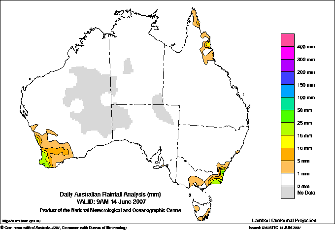
Todays highest rainfall totals for the 24 hours to 9am. It
includes the top 5 totals nationally followed by all reported falls of 50mm or more. |
Highest
and lowest recordings of hours of sunshine for the 24 hours to midnight. |
Highest wind
run totals in kilometres for the 24 hours to 9am (average speed in brackets).
All reported runs >
=25km/h are shown. |
Highest wind
gusts in km/h for the 24 hours to midnight followed by the hour in which it occurred.
All stations with gusts >
89km/h are shown. |
109.6 COBARGO POST OFFICE South Coast NSW
49.0 LANCELIN Lower West WA
48.2 CAPE NATURALISTE Lower West WA
45.0 COBARGO (COOLAGOLITE (LYREBIRD RIDGE RD) South Coast NSW
44.2 BERMAGUI SOUTH (YOUNG STREET) South Coast NSW
WESTERN AUSTRALIA
Lower West
49.0 LANCELIN
48.2 CAPE NATURALISTE
NEW SOUTH WALES
South Coast
109.6 COBARGO POST OFFICE
45.0 COBARGO (COOLAGOLITE (LYREBIRD RIDGE RD)
44.2 BERMAGUI SOUTH (YOUNG STREET)
|
10.6 RABBIT FLAT N Plateau NT
10.5 BROOME AIRPORT W Kimberley WA
10.4 ALICE SPRINGS AIRPORT N Plateau NT
10.4 MOUNT ISA AERO Gulf Country QLD
10.3 GILES METEOROLOGICAL OFFICE Interior WA
10.3 TENNANT CREEK AIRPORT N Plateau NT
.....
0.1 COWRA RESEARCH CENTRE (EVANS ST) C Tablelands S NSW
0.0 TOWNSVILLE AERO N Coast--Herbert QLD
0.0 MACKAY M.O Central Coast E QLD
0.0 KAIRI RESEARCH STATION N Coast--Barron QLD
0.0 BRIAN PASTURES Brisbane/SE Coast QLD
|
1285 (53.5) MONTAGUE ISLAND LIGHTHOUSE South Coast NSW
1230 (51.3) GREEN CAPE AWS South Coast NSW
993 (41.4) WILLIS ISLAND Islands ISL
952 (39.7) FALLS CREEK Upper NE VIC
950 (39.6) EDDYSTONE POINT E Coast TAS
920 (38.3) LOW ISLES LIGHTHOUSE N Coast--Barron QLD
897 (37.4) MT HOTHAM Upper NE VIC
834 (34.8) CAPE FLATTERY N Coast--Barron QLD
784 (32.7) HOGAN ISLAND Islands ISL
677 (28.2) THREDBO AWS Snowy Mtns NSW
675 (28.1) DOUBLE ISLAND POINT LIGHTHOUSE Brisbane/SE Coast QLD
649 (27.0) CAPE LEEUWIN Lower West WA
641 (26.7) COOMA AIRPORT AWS Goulburn/Monaro NSW
630 (26.3) JERVIS BAY (POINT PERPENDICULAR AWS) Illawarra NSW
621 (25.9) HERON ISLAND RES STN Wide Bay/Burnett QLD
620 (25.8) VARANUS ISLAND Islands ISL
619 (25.8) MCCLUER ISLAND N Rivers NT
606 (25.3) ESPERANCE AERO Lower West WA
600 (25.0) CAIRNS AERO N Coast--Barron QLD
|
96/06 MONTAGUE ISLAND LIGHTHOUSE South Coast NSW
83/01 GREEN CAPE AWS South Coast NSW
78/19 BELLAMBI AWS Illawarra NSW
78/01 GABO ISLAND LIGHTHOUSE E Gippsland VIC
72/13 CABRAMURRA SMHEA AWS SW Slopes S NSW
|
�