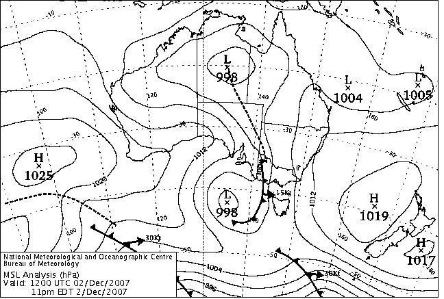
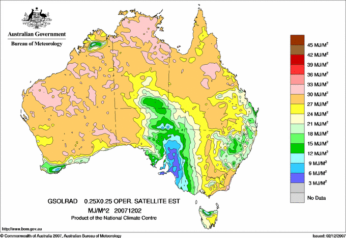
|
For notes on how to interpret
the data and quality control issues, see Daily Weather Summary Help.
**S** and **W** precede data flagged by the Bureau as suspicious or wrong
Data is as received at 01:38EST, 15/05/2012.
|
|
| |
Max
°
C |
+/- norm
°
C |
Min
°
C |
+/- norm
°
C |
Grass Min
°
C |
Rain to 9am mm |
Evaporation to 9am mm |
Sunshine hours |
Wind Run to 9am km (24-hour average km/h) |
Maximum Gust km/h / hour of occurrence |
| GERALDTON AIRPORT |
24.7 |
-4.8 |
11.1 |
-5.2 |
9.0 |
0.6 |
8.6 |
-- |
627 (26.1) |
58/17 |
| PERTH AIRPORT |
23.8 |
-5.1 |
8.1 |
-6.7 |
6.9 |
0.8 |
5.4 |
13.1 |
497 (20.7) |
48/16 |
| ALBANY AIRPORT |
18.6 |
-4.5 |
12.2 |
-0.2 |
10.8 |
0.4 |
4.4 |
6.7 |
424 (17.7) |
-- |
| BUNBURY |
20.8 |
-6.3 |
13.5 |
+0.2 |
-- |
0.2 |
-- |
-- |
300 (12.5) |
39/16 |
| MANDURAH |
21.6 |
-- |
12.5 |
-- |
-- |
0.0 |
-- |
-- |
461 (19.2) |
41/21 |
| DARWIN AIRPORT |
34.1 |
+1.5 |
29.2 |
+3.9 |
28.2 |
0.0 |
7.8 |
11.4 |
595 (24.8) |
43/11 |
| ALICE SPRINGS AIRPORT |
39.9 |
+4.5 |
26.3 |
+6.1 |
24.0 |
0.0 |
16.8 |
8.9 |
329 (13.7) |
35/05 |
| WHYALLA AERO |
27.4 |
-0.7 |
19.5 |
+3.7 |
-- |
0.0 |
-- |
-- |
242 (10.1) |
46/08 |
| ADELAIDE (KENT TOWN) |
28.6 |
+1.6 |
22.0 |
+6.5 |
17.9 |
0.0 |
-- |
-- |
204 ( 8.5) |
61/08 |
| MOUNT GAMBIER AERO |
32.8 |
+9.9 |
13.9 |
+4.0 |
11.1 |
0.0 |
6.8 |
2.8 |
359 (15.0) |
46/13 |
| MOUNT ISA AERO |
42.3 |
+5.1 |
20.1 |
-3.0 |
17.9 |
0.0 |
16.0 |
12.7 |
357 (14.9) |
34/10 |
| CAIRNS AERO |
36.1 |
+4.7 |
24.6 |
+1.2 |
21.4 |
0.0 |
6.6 |
11.8 |
233 ( 9.7) |
43/12 |
| TOWNSVILLE AERO |
30.9 |
-0.6 |
25.4 |
+1.3 |
24.1 |
0.0 |
8.0 |
11.6 |
349 (14.5) |
45/15 |
| MACKAY M.O |
28.1 |
-2.0 |
20.3 |
-2.6 |
-- |
2.2 |
-- |
12.1 |
383 (16.0) |
41/15 |
| ROCKHAMPTON AERO |
28.5 |
-3.6 |
18.2 |
-3.0 |
18.0 |
0.4 |
4.8 |
-- |
369 (15.4) |
43/14 |
| BUNDABERG AERO |
26.3 |
-3.1 |
19.3 |
-1.2 |
-- |
2.0 |
2.2 |
-- |
398 (16.6) |
44/11 |
| NAMBOUR DPI |
25.8 |
-3.4 |
17.3 |
-0.9 |
-- |
0.0 |
-- |
-- |
83 ( 3.5) |
30/14 |
| COOLANGATTA |
26.8 |
-0.4 |
18.4 |
-1.5 |
-- |
8.8 |
-- |
-- |
240 (10.0) |
34/13 |
| BRISBANE AERO |
26.5 |
-1.8 |
18.8 |
-1.3 |
17.2 |
3.0 |
7.0 |
4.3 |
329 (13.7) |
39/11 |
| TOOWOOMBA AIRPORT |
24.4 |
-3.3 |
15.5 |
-1.2 |
-- |
0.0 |
-- |
-- |
605 (25.2) |
37/14 |
| GUNNEDAH RESOURCE CENTRE |
27.0 |
-4.0 |
17.9 |
+0.4 |
17.2 |
2.0 |
4.2 |
-- |
167 ( 7.0) |
-- |
| COFFS HARBOUR MO |
24.9 |
-1.4 |
17.4 |
-0.7 |
16.2 |
0.0 |
4.6 |
7.2 |
254 (10.6) |
41/18 |
| PORT MACQUARIE AIRPORT AWS |
24.7 |
-1.9 |
16.2 |
-0.5 |
-- |
0.0 |
-- |
-- |
-- |
-- |
| WILLIAMTOWN RAAF |
24.1 |
-3.1 |
14.5 |
-2.0 |
14.0 |
2.6 |
5.2 |
2.8 |
361 (15.0) |
35/17 |
| GOSFORD (NARARA RESEARCH STATION) AWS |
24.5 |
-2.4 |
15.0 |
-0.3 |
-- |
39.8 |
-- |
-- |
67 ( 2.8) |
18/15 |
| ORANGE AGRICULTURAL INSTITUTE |
21.2 |
-3.2 |
10.3 |
-1.0 |
8.7 |
1.8 |
3.4 |
5.0 |
-- |
-- |
| DUBBO AIRPORT AWS |
26.4 |
-5.1 |
16.6 |
+0.7 |
-- |
50.0 |
-- |
-- |
-- |
-- |
| SYDNEY AIRPORT AMO |
24.7 |
-1.0 |
18.4 |
+0.9 |
16.0 |
0.6 |
3.2 |
12.3 |
435 (18.1) |
41/18 |
| RICHMOND RAAF |
25.6 |
-3.1 |
16.3 |
+0.3 |
-- |
2.4 |
-- |
-- |
173 ( 7.2) |
44/20 |
| BELLAMBI AWS |
23.7 |
-0.4 |
16.3 |
-1.2 |
-- |
0.0 |
-- |
-- |
310 (12.9) |
39/16 |
| CANBERRA AIRPORT |
26.3 |
+0.2 |
11.6 |
+0.2 |
9.2 |
4.2 |
1.6 |
12.0 |
225 ( 9.4) |
41/17 |
| WAGGA WAGGA AMO |
29.7 |
+0.3 |
16.4 |
+2.7 |
14.6 |
0.6 |
7.0 |
12.4 |
451 (18.8) |
41/06 |
| ALBURY AIRPORT AWS |
30.0 |
+0.6 |
15.1 |
+1.4 |
-- |
0.0 |
-- |
-- |
195 ( 8.1) |
26/11 |
| MILDURA AIRPORT |
35.1 |
+5.0 |
22.6 |
+7.8 |
19.8 |
0.0 |
12.0 |
6.2 |
295 (12.3) |
63/17 |
| TATURA INST SUSTAINABLE AG |
31.5 |
+4.1 |
-- |
-- |
-- |
0.0 |
-- |
-- |
-- |
39/06 |
| BENDIGO AIRPORT |
31.7 |
+4.7 |
16.3 |
+4.8 |
-- |
0.0 |
-- |
-- |
292 (12.2) |
�
46/12 |
| MELBOURNE REGIONAL OFFICE |
32.3 |
+8.1 |
18.2 |
+5.3 |
15.0 |
0.0 |
5.6 |
-- |
159 ( 6.6) |
32/07 |
| GEELONG AIRPORT |
33.4 |
+10.5 |
10.4 |
-0.5 |
-- |
0.0 |
-- |
-- |
276 (11.5) |
61/18 |
| BALLARAT AERODROME |
29.6 |
+7.0 |
-- |
-- |
-- |
0.0 |
-- |
-- |
-- |
55/08 |
| LAUNCESTON (TI TREE BEND) |
23.4 |
+1.0 |
12.4 |
+1.8 |
-- |
0.0 |
-- |
-- |
208 ( 8.7) |
35/11 |
| HOBART AIRPORT |
31.6 |
+11.0 |
11.4 |
+0.7 |
8.0 |
0.0 |
9.2 |
11.0 |
387 (16.1) |
46/11 |
| |
Max
°
C |
+/- norm
°
C |
Min
°
C |
+/- norm
°
C |
Grass Min
°
C |
Rain to 9am mm |
Evaporation to 9am mm |
Sunshine hours |
Wind Run to 9am km |
Maximum Gust km/h / hour of occurrence |
|
| Hottest |
| Highest maximum temperature> | Greatest variation above normal maximum |
Highest minimum temperature | Greatest variation above normal minimum |
46.0 ALI CURUNG N Plateau NT
45.5 BRUNETTE DOWNS N Plateau NT
45.4 TENNANT CREEK AIRPORT N Plateau NT
45.2 WAVE HILL N Rivers NT
|
+12.9 : 31.2 SCOTTS PEAK DAM W Coast TAS
+12.6 : 27.4 HARTZ MOUNTAIN (KEOGHS PIMPLE) Southeast TAS
+12.4 : 31.9 CAPE NELSON LIGHTHOUSE W Coast VIC
+11.8 : 33.0 PORT FAIRY AWS W Coast VIC
+11.8 : 32.9 AIREYS INLET W Coast VIC
|
30.7 CENTRE ISLAND N Rivers NT
30.3 NGAYAWILI N Rivers NT
30.1 MCARTHUR RIVER MINE N Rivers NT
30.1 LAJAMANU N Rivers NT
30.0 WYNDHAM N Kimberley WA
|
+9.1 : 20.0 MOUNT LOFTY Adelaide/Lofty SA
+9.0 : 21.1 LAMEROO COMPARISON Mallee/Upper SE SA
+8.9 : 26.5 WOOMERA AERODROME NW Pastoral SA
+8.6 : 22.0 ROSEDALE (TURRETFIELD RESEARCH CENTRE) Adelaide/Lofty SA
+8.2 : 26.8 ROXBY DOWNS (OLYMPIC DAM AERODROME) NW Pastoral SA
|
| Coldest |
| Lowest maximum temperature | Greatest variation below normal maximum |
Lowest minimum temperature | Greatest variation below normal minimum |
13.9 MT HOTHAM Upper NE VIC
15.5 THREDBO AWS Snowy Mtns NSW
15.8 MOUNT BULLER Upper NE VIC
16.3 FALLS CREEK Upper NE VIC
|
-7.9 : 25.0 DALWALLINU COMPARISON Central West WA
-7.3 : 20.7 KARNET Lower West WA
-7.1 : 18.3 ROCKY GULLY Lower West WA
-6.9 : 21.0 BICKLEY Lower West WA
-6.8 : 23.5 GOSNELLS CITY Lower West WA
|
1.6 LIAWENEE Central Plateau TAS
2.3 WANDERING Cent Wheatbelt WA
4.5 THREDBO VILLAGE Snowy Mtns NSW
5.0 GROVE (RESEARCH STATION) Southeast TAS
5.0 MOUNT GININI AWS Goulburn/Monaro NSW
|
-9.4 : 2.3 WANDERING Cent Wheatbelt WA
-8.5 : 6.0 JANDAKOT AERO Lower West WA
-7.3 : 6.5 HYDEN Cent Wheatbelt WA
-7.0 : 8.3 NORTHAM Cent Wheatbelt WA
-6.9 : 7.4 BEVERLEY Cent Wheatbelt WA
|
|
Sunniest &
dullest |
Windiest |
Highest gusts |
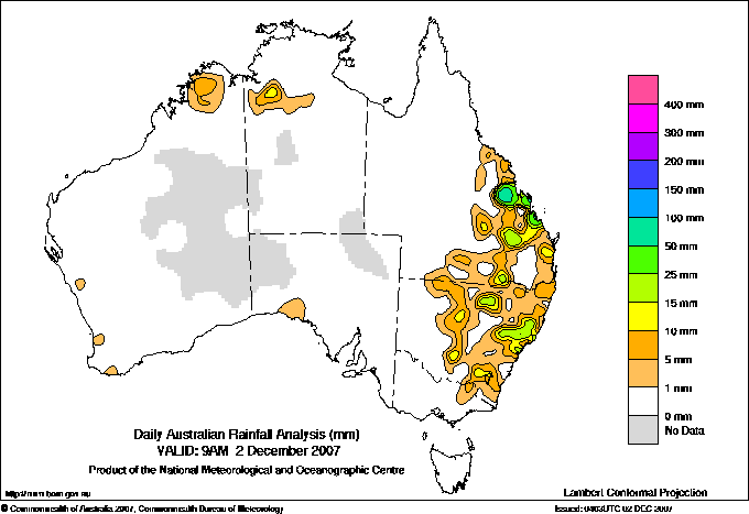
Todays highest rainfall totals for the 24 hours to 9am. It
includes the top 5 totals nationally followed by all reported falls of 50mm or more. |
Highest
and lowest recordings of hours of sunshine for the 24 hours to midnight. |
Highest wind
run totals in kilometres for the 24 hours to 9am (average speed in brackets).
All reported runs >
=25km/h are shown. |
Highest wind
gusts in km/h for the 24 hours to midnight followed by the hour in which it occurred.
All stations with gusts >
89km/h are shown. |
134.0 RAGLAN Wide Bay/Burnett QLD
105.0 SAMUEL HILL AERO Central Coast E QLD
81.0 WYONG (OLNEY FOREST) Hunter Valley NSW
69.6 DARTS CREEK Wide Bay/Burnett QLD
68.0 WITTITRIN MidNorth Coast N NSW
QUEENSLAND
Central Coast E
105.0 SAMUEL HILL AERO
Wide Bay/Burnett
134.0 RAGLAN
69.6 DARTS CREEK
67.0 SOUTHEND CURTIS ISLAND
65.2 GLADSTONE AIRPORT
62.2 GLADSTONE RADAR
NEW SOUTH WALES
MidNorth Coast N
68.0 WITTITRIN
Hunter Valley
81.0 WYONG (OLNEY FOREST)
61.0 WAMBERAL (TERRIGAL MEMORIAL COUNTRY CLUB
54.0 SALISBURY (BARRINGTON WILDERNESS COTTAGE
51.8 AVOCA BEACH BOWLING CLUB
51.0 YARRAMALONG (LEWENSBROOK)
CW Slopes S
50.0 DUBBO AIRPORT AWS
|
13.1 PERTH AIRPORT Lower West WA
12.8 GILES METEOROLOGICAL OFFICE Interior WA
12.7 MOUNT ISA AERO Gulf Country QLD
12.4 RABBIT FLAT N Plateau NT
12.4 WAGGA WAGGA AMO SW Slopes S NSW
.....
2.5 LOXTON RESEARCH CENTRE Murray Valley SA
1.8 ADELAIDE AIRPORT Adelaide/Lofty SA
1.2 NURIOOTPA VITICULTURAL Adelaide/Lofty SA
1.0 WELLINGTON (AGROWPLOW) CW Slopes S NSW
0.0 WARWICK Darling Downs E QLD
|
928 (38.7) WILSONS PROMONTORY LIGHTHOUSE W Gippsland VIC
906 (37.8) RUNDLE ISLAND Wide Bay/Burnett QLD
852 (35.5) HOGAN ISLAND Islands ISL
850 (35.4) CARNARVON AIRPORT W Gascoyne WA
841 (35.0) LADY ELLIOT ISLAND Wide Bay/Burnett QLD
839 (35.0) CAPE GRIM BAPS N Coast TAS
804 (33.5) ROTTNEST ISLAND Lower West WA
781 (32.5) NGAYAWILI N Rivers NT
773 (32.2) VARANUS ISLAND Islands ISL
742 (30.9) HOPETOUN NORTH Lower West WA
725 (30.2) BARROW ISLAND AIRPORT W Pilbara WA
711 (29.6) DOUBLE ISLAND POINT LIGHTHOUSE Brisbane/SE Coast QLD
710 (29.6) HERON ISLAND RES STN Wide Bay/Burnett QLD
696 (29.0) ESPERANCE AERO Lower West WA
692 (28.8) MCCLUER ISLAND N Rivers NT
686 (28.6) SHARK BAY AIRPORT W Gascoyne WA
680 (28.3) NORTH ISLAND Central West WA
676 (28.2) COCOS ISLAND AIRPORT Islands ISL
671 (28.0) GARDEN ISLAND HSF Lower West WA
668 (27.8) LEARMONTH AIRPORT W Pilbara WA
658 (27.4) MUNGLINUP WEST Goldfields WA
640 (26.7) ESPERANCE Lower West WA
630 (26.3) THEVENARD ISLAND W Pilbara WA
627 (26.1) GERALDTON AIRPORT Central West WA
621 (25.9) SMITHTON AERODROME N Coast TAS
605 (25.2) TOOWOOMBA AIRPORT Darling Downs E QLD
|
81/11 TASMAN ISLAND Southeast TAS
78/09 ADELAIDE AIRPORT Adelaide/Lofty SA
78/08 CAPE GRIM BAPS N Coast TAS
72/16 COOBER PEDY AIRPORT NW Pastoral SA
72/00 ERNABELLA (PUKATJA) NW Pastoral SA
|
�