|
For notes on how to interpret
the data and quality control issues, see Daily Weather Summary Help.
**S** and **W** precede data flagged by the Bureau as suspicious or wrong
Data is as received at 00:12EST, 15/05/2012.
|
|
| |
Max
°
C |
+/- norm
°
C |
Min
°
C |
+/- norm
°
C |
Grass Min
°
C |
Rain to 9am mm |
Evaporation to 9am mm |
Sunshine hours |
Wind Run to 9am km (24-hour average km/h) |
Maximum Gust km/h / hour of occurrence |
| GERALDTON AIRPORT |
45.2 |
+14.3 |
28.3 |
+10.4 |
26.8 |
0.0 |
21.4 |
-- |
647 (27.0) |
46/09 |
| PERTH AIRPORT |
42.5 |
+12.9 |
25.1 |
+9.3 |
19.2 |
0.0 |
12.0 |
11.9 |
484 (20.2) |
45/13 |
| ALBANY AIRPORT |
37.0 |
+12.9 |
15.5 |
+2.1 |
12.5 |
0.0 |
8.0 |
11.4 |
411 (17.1) |
43/13 |
| BUNBURY |
39.5 |
+12.0 |
19.2 |
+5.2 |
-- |
0.0 |
-- |
-- |
256 (10.7) |
31/09 |
| MANDURAH |
37.8 |
-- |
24.8 |
-- |
-- |
0.0 |
-- |
-- |
333 (13.9) |
34/08 |
| DARWIN AIRPORT |
31.2 |
-0.7 |
24.2 |
-0.3 |
23.9 |
1.2 |
0.6 |
1.1 |
302 (12.6) |
45/14 |
| ALICE SPRINGS AIRPORT |
32.8 |
+0.1 |
20.8 |
+3.3 |
19.3 |
0.0 |
18.0 |
11.8 |
501 (20.9) |
44/08 |
| WHYALLA AERO |
23.9 |
-3.4 |
16.8 |
+1.5 |
-- |
0.0 |
6.0 |
-- |
582 (24.3) |
52/16 |
| ADELAIDE (KENT TOWN) |
25.1 |
-1.2 |
14.1 |
-1.1 |
-- |
0.0 |
-- |
-- |
438 (18.3) |
-- |
| MOUNT GAMBIER AERO |
23.2 |
+0.1 |
9.3 |
-1.2 |
6.2 |
0.0 |
4.8 |
10.3 |
502 (20.9) |
50/16 |
| MOUNT ISA AERO |
39.6 |
+5.3 |
26.3 |
+4.5 |
24.4 |
0.0 |
9.6 |
9.0 |
284 (11.8) |
54/19 |
| CAIRNS AERO |
32.8 |
+2.3 |
22.4 |
-0.6 |
19.1 |
0.0 |
8.4 |
8.7 |
288 (12.0) |
46/15 |
| TOWNSVILLE AERO |
31.9 |
+1.2 |
24.9 |
+2.0 |
22.9 |
1.4 |
7.0 |
10.6 |
342 (14.3) |
41/22 |
| MACKAY M.O |
29.7 |
+1.1 |
26.0 |
+3.8 |
-- |
0.4 |
-- |
10.9 |
522 (21.8) |
43/10 |
| ROCKHAMPTON AERO |
32.7 |
+2.2 |
23.4 |
+2.6 |
22.1 |
0.0 |
7.6 |
-- |
355 (14.8) |
37/15 |
| BUNDABERG AERO |
31.5 |
+2.4 |
22.6 |
+2.7 |
-- |
0.1 |
4.1 |
-- |
401 (16.7) |
48/16 |
| NAMBOUR DPI |
27.7 |
-0.2 |
21.0 |
+2.8 |
-- |
1.8 |
-- |
-- |
86 ( 3.6) |
37/17 |
| COOLANGATTA |
29.3 |
+2.1 |
22.2 |
+2.6 |
-- |
11.6 |
-- |
-- |
228 ( 9.5) |
59/15 |
| BRISBANE AERO |
30.3 |
+2.3 |
22.6 |
+3.3 |
21.2 |
0.0 |
5.2 |
6.1 |
354 (14.8) |
52/15 |
| TOOWOOMBA AIRPORT |
27.6 |
+1.2 |
18.3 |
+2.2 |
-- |
2.8 |
-- |
-- |
522 (21.8) |
55/21 |
| GUNNEDAH RESOURCE CENTRE |
27.6 |
-1.5 |
18.7 |
+2.1 |
15.3 |
0.6 |
5.2 |
-- |
288 (12.0) |
-- |
| COFFS HARBOUR MO |
24.2 |
-1.7 |
19.8 |
+1.7 |
19.0 |
44.0 |
4.2 |
0.3 |
212 ( 8.8) |
58/13 |
| PORT MACQUARIE AIRPORT AWS |
24.4 |
-1.9 |
20.3 |
+3.6 |
-- |
20.0 |
-- |
-- |
-- |
-- |
| WILLIAMTOWN RAAF |
24.8 |
-1.4 |
19.5 |
+3.2 |
18.1 |
13.4 |
3.6 |
4.0 |
552 (23.0) |
52/00 |
| GOSFORD (NARARA RESEARCH STATION) AWS |
23.9 |
-2.1 |
18.1 |
+2.8 |
-- |
18.0 |
-- |
-- |
225 ( 9.4) |
37/01 |
| ORANGE AGRICULTURAL INSTITUTE |
20.8 |
-2.0 |
12.4 |
+1.8 |
11.1 |
0.0 |
2.6 |
8.0 |
-- |
-- |
| DUBBO AIRPORT AWS |
26.0 |
-3.1 |
18.4 |
+3.9 |
-- |
9.0 |
-- |
-- |
-- |
-- |
| SYDNEY AIRPORT AMO |
22.8 |
-2.4 |
20.0 |
+2.6 |
19.5 |
10.6 |
6.6 |
8.9 |
865 (36.0) |
58/23 |
| RICHMOND RAAF |
24.1 |
-2.8 |
17.8 |
+2.3 |
-- |
4.2 |
-- |
-- |
257 (10.7) |
41/15 |
| BELLAMBI AWS |
-- |
-- |
-- |
-- |
-- |
-- |
-- |
-- |
-- |
-- |
| CANBERRA AIRPORT |
23.2 |
-1.3 |
12.1 |
+1.4 |
11.8 |
0.0 |
8.8 |
9.5 |
447 (18.6) |
43/11 |
| WAGGA WAGGA AMO |
29.1 |
+1.4 |
14.2 |
+0.8 |
13.3 |
0.0 |
8.4 |
10.6 |
379 (15.8) |
-- |
| ALBURY AIRPORT AWS |
28.6 |
+0.7 |
14.1 |
+1.5 |
-- |
0.0 |
-- |
-- |
316 (13.2) |
39/08 |
| MILDURA AIRPORT |
27.0 |
-1.3 |
11.7 |
-2.1 |
10.5 |
0.0 |
10.0 |
4.9 |
490 (20.4) |
39/23 |
| TATURA INST SUSTAINABLE AG |
27.8 |
+1.5 |
9.6 |
-2.1 |
-- |
0.0 |
10.6 |
-- |
647 (27.0) |
50/23 |
| BENDIGO AIRPORT |
26.4 |
+0.4 |
11.1 |
-0.2 |
-- |
0.0 |
-- |
-- |
650 (27.1) |
�
58/00 |
| MELBOURNE REGIONAL OFFICE |
27.0 |
+3.1 |
14.7 |
+1.5 |
11.4 |
0.0 |
5.4 |
-- |
172 ( 7.2) |
24/10 |
| GEELONG AIRPORT |
21.8 |
-1.4 |
13.4 |
+1.6 |
-- |
0.0 |
-- |
-- |
588 (24.5) |
55/17 |
| BALLARAT AERODROME |
22.5 |
+0.3 |
9.7 |
-0.2 |
-- |
0.0 |
-- |
-- |
744 (31.0) |
61/04 |
| LAUNCESTON (TI TREE BEND) |
22.0 |
-0.5 |
7.7 |
-2.3 |
-- |
0.0 |
-- |
-- |
339 (14.1) |
39/09 |
| HOBART AIRPORT |
16.3 |
-4.4 |
10.1 |
-0.6 |
5.8 |
0.4 |
2.6 |
5.5 |
556 (23.2) |
32/00 |
| |
Max
°
C |
+/- norm
°
C |
Min
°
C |
+/- norm
°
C |
Grass Min
°
C |
Rain to 9am mm |
Evaporation to 9am mm |
Sunshine hours |
Wind Run to 9am km |
Maximum Gust km/h / hour of occurrence |
|
| Hottest |
| Highest maximum temperature> | Greatest variation above normal maximum |
Highest minimum temperature | Greatest variation above normal minimum |
47.8 CARNARVON AIRPORT W Gascoyne WA
47.2 SHARK BAY AIRPORT W Gascoyne WA
47.2 KALBARRI Central West WA
46.5 GASCOYNE JUNCTION W Gascoyne WA
46.2 DENHAM W Gascoyne WA
46.2 EMU CREEK STATION W Gascoyne WA
|
+16.3 : 47.8 CARNARVON AIRPORT W Gascoyne WA
+15.3 : 46.2 DENHAM W Gascoyne WA
+15.2 : 43.5 LANCELIN Lower West WA
+15.2 : 39.6 PEMBERTON Lower West WA
+14.9 : 39.6 MANJIMUP Lower West WA
|
30.8 GASCOYNE JUNCTION W Gascoyne WA
30.6 NEWMAN AERO E Gascoyne WA
29.4 MARBLE BAR E Pilbara WA
29.0 PARDOO STATION E Pilbara WA
29.0 TELFER AERO Interior WA
|
+11.6 : 28.3 LANCELIN Lower West WA
+11.5 : 27.3 PEARCE RAAF Lower West WA
+10.4 : 28.3 GERALDTON AIRPORT Central West WA
+10.2 : 28.5 MULLEWA Central West WA
+10.0 : 25.2 JANDAKOT AERO Lower West WA
+10.0 : 25.0 GINGIN AERO Lower West WA
|
| Coldest |
| Lowest maximum temperature | Greatest variation below normal maximum |
Lowest minimum temperature | Greatest variation below normal minimum |
6.1 MOUNT WELLINGTON Southeast TAS
10.8 THREDBO AWS Snowy Mtns NSW
11.6 MT BAW BAW W Gippsland VIC
11.8 LAKE LEAKE (ELIZABETH RIVER) E Coast TAS
12.0 PERISHER VALLEY SKI CENTRE Snowy Mtns NSW
|
-8.2 : 25.0 DOONGAN N Kimberley WA
-8.2 : 25.4 KALUMBURU N Kimberley WA
-7.8 : 14.3 BOMBALA AWS Goulburn/Monaro NSW
-6.9 : 13.6 NULLO MOUNTAIN AWS C Tablelands N NSW
-6.4 : 16.2 BOMBALA (THERRY STREET) Goulburn/Monaro NSW
-6.4 : 15.0 OBERON (WOODCHEM) C Tablelands S NSW
|
-2.5 PERISHER VALLEY SKI CENTRE Snowy Mtns NSW
-2.4 CHARLOTTE PASS (KOSCIUSKO CHALET) Snowy Mtns NSW
-2.1 THREDBO AWS Snowy Mtns NSW
-2.1 LIAWENEE Central Plateau TAS
-1.8 LAKE ST CLAIR NATIONAL PARK Central Plateau TAS
|
-7.0 : -2.1 THREDBO AWS Snowy Mtns NSW
-6.9 : -0.7 FALLS CREEK Upper NE VIC
-6.9 : -1.2 TARRALEAH VILLAGE Derwent Valley TAS
-6.8 : 0.9 OUSE FIRE STATION Derwent Valley TAS
-6.5 : 1.9 BUSHY PARK (BUSHY PARK ESTATES) Derwent Valley TAS
|
|
Sunniest &
dullest |
Windiest |
Highest gusts |
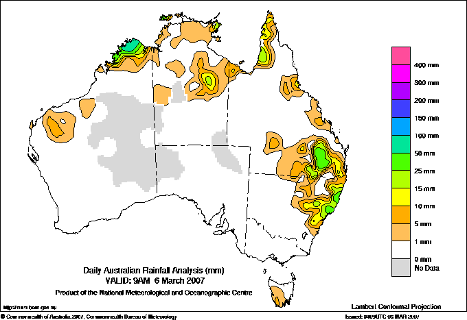
Todays highest rainfall totals for the 24 hours to 9am. It
includes the top 5 totals nationally followed by all reported falls of 50mm or more. |
Highest
and lowest recordings of hours of sunshine for the 24 hours to midnight. |
Highest wind
run totals in kilometres for the 24 hours to 9am (average speed in brackets).
All reported runs >
=25km/h are shown. |
Highest wind
gusts in km/h for the 24 hours to midnight followed by the hour in which it occurred.
All stations with gusts >
89km/h are shown. |
81.0 DAANDINE Darling Downs E QLD
78.6 HANNAFORD POST OFFICE Darling Downs W QLD
75.0 KALUMBURU N Kimberley WA
72.6 BELLBROOK (MAIN STREET) MidNorth Coast N NSW
72.4 COOLAH (BINNIA ST) CW Slopes N NSW
WESTERN AUSTRALIA
N Kimberley
75.0 KALUMBURU
65.0 THEDA
54.0 FARAWAY BAY
QUEENSLAND
N Peninsula
58.0 SKARDON RIVER
Brisbane/SE Coast
50.0 TALLEGALLA ALERT
Darling Downs E
81.0 DAANDINE
71.0 O'CONNOR TM
60.4 WARONGA
56.0 TOORA
Darling Downs W
78.6 HANNAFORD POST OFFICE
67.0 DULACCA TRUCK STOP
57.0 BARAKULA FOREST STN
NEW SOUTH WALES
MidNorth Coast N
72.6 BELLBROOK (MAIN STREET)
69.0 BELLBROOK (MACLEAY RIVER)
67.6 LEIGH (ROLLING ACRES)
60.8 GIRRALONG
58.0 BOWRA SUGARLOAF
50.3 CORAMBA (GLENFIDDICH)
MidNorth Coast S
59.0 BULAHDELAH POST OFFICE
54.0 CRAWFORD RIVER (CRAWFORD)
50.0 CABBAGE TREE MOUNTAIN
Hunter Valley
57.4 PATERSON POST OFFICE
CW Slopes N
72.4 COOLAH (BINNIA ST)
ISLANDS
Islands
64.4 COCOS ISLAND AIRPORT
50.6 POINT FAWCETT
|
11.9 PERTH AIRPORT Lower West WA
11.9 GILES METEOROLOGICAL OFFICE Interior WA
11.8 ALICE SPRINGS AIRPORT N Plateau NT
11.5 CEDUNA AMO W Agricultural SA
11.4 ALBANY AIRPORT Lower West WA
11.4 MOREE AERO NW Plains E NSW
.....
4.0 WILLIAMTOWN RAAF Hunter Valley NSW
3.5 BROOME AIRPORT W Kimberley WA
2.2 SCONE SCS Hunter Valley NSW
1.1 DARWIN AIRPORT N Rivers NT
0.3 COFFS HARBOUR MO MidNorth Coast N NSW
|
1038 (43.3) HOGAN ISLAND Islands ISL
1034 (43.1) MOUNT WELLINGTON Southeast TAS
1009 (42.0) WILSONS PROMONTORY LIGHTHOUSE W Gippsland VIC
1002 (41.8) CAPE GRIM BAPS N Coast TAS
957 (39.9) MOUNT READ W Coast TAS
922 (38.4) CAPE WILLOUGHBY Yorke Pen/Kanga Is SA
917 (38.2) MAATSUYKER ISLAND LIGHTHOUSE Southeast TAS
885 (36.9) MONTAGUE ISLAND LIGHTHOUSE South Coast NSW
865 (36.0) SYDNEY AIRPORT AMO Sydney--east NSW
859 (35.8) GREEN CAPE AWS South Coast NSW
856 (35.7) KILMORE GAP N Central VIC
852 (35.5) HINDMARSH ISLAND AWS Adelaide/Lofty SA
835 (34.8) NORAH HEAD AWS Hunter Valley NSW
816 (34.0) EDDYSTONE POINT E Coast TAS
805 (33.5) LOW HEAD N Coast TAS
783 (32.6) RUNDLE ISLAND Wide Bay/Burnett QLD
782 (32.6) HAMILTON ISLAND AIRPORT Central Coast E QLD
776 (32.3) REDESDALE N Central VIC
769 (32.0) SWAN ISLAND E Coast TAS
755 (31.5) NEWCASTLE NOBBYS SIGNAL STATION AWS Hunter Valley NSW
753 (31.4) MOOMBA AIRPORT NE Pastoral SA
752 (31.3) BIRDSVILLE AIRPORT Channel Country QLD
750 (31.3) NORFOLK ISLAND AERO Islands ISL
744 (31.0) BALLARAT AERODROME Western Plains VIC
738 (30.8) NEPTUNE ISLAND W Agricultural SA
736 (30.7) PARAWA (SECOND VALLEY FOREST AWS) Adelaide/Lofty SA
731 (30.5) CAPE BRUNY (CAPE BRUNY) Southeast TAS
723 (30.1) MANGALORE AIRPORT N Central VIC
721 (30.0) MELBOURNE AIRPORT E Central VIC
718 (29.9) EDITHBURGH Yorke Pen/Kanga Is SA
715 (29.8) TIBOOBURRA AIRPORT Far Northwest NSW
697 (29.0) LADY ELLIOT ISLAND Wide Bay/Burnett QLD
695 (29.0) CEDUNA AMO W Agricultural SA
693 (28.9) NULLARBOR W Agricultural SA
692 (28.8) MURRURUNDI GAP AWS Hunter Valley NSW
689 (28.7) COLAC (MT GELLIBRAND) W Coast VIC
685 (28.5) TASMAN ISLAND Southeast TAS
675 (28.1) STENHOUSE BAY Yorke Pen/Kanga Is SA
667 (27.8) FLINDERS ISLAND AIRPORT Flinders Is/Bass St TAS
665 (27.7) AVALON AIRPORT W Central VIC
665 (27.7) LOOKOUT HILL Western Plains VIC
662 (27.6) NORTH SHIELDS (PORT LINCOLN AWS) W Agricultural SA
653 (27.2) PORT AUGUSTA AERO W Agricultural SA
653 (27.2) MINLATON AERO Yorke Pen/Kanga Is SA
650 (27.1) DENILIQUIN AIRPORT AWS Riverina E NSW
650 (27.1) BENDIGO AIRPORT Upper North VIC
647 (27.0) GERALDTON AIRPORT Central West WA
647 (27.0) TATURA INST SUSTAINABLE AG Upper North VIC
638 (26.6) WALPEUP RESEARCH Mallee N VIC
638 (26.6) WILLIS ISLAND Islands ISL
635 (26.5) CAPE OTWAY LIGHTHOUSE W Coast VIC
628 (26.2) CAPE JAFFA (CURLEY HILLS) Lower SE SA
628 (26.2) LONGERENONG Wimmera S VIC
618 (25.8) PORT FAIRY AWS W Coast VIC
613 (25.5) FALLS CREEK Upper NE VIC
612 (25.5) WOOMERA AERODROME NW Pastoral SA
612 (25.5) HERON ISLAND RES STN Wide Bay/Burnett QLD
612 (25.5) AIREYS INLET W Coast VIC
607 (25.3) CAPE NELSON LIGHTHOUSE W Coast VIC
|
80/17 TREPELL AIRPORT Northwest QLD
76/08 MURRURUNDI GAP AWS Hunter Valley NSW
74/16 GOLD COAST SEAWAY Brisbane/SE Coast QLD
72/23 CAPE MORETON LIGHTHOUSE Brisbane/SE Coast QLD
72/05 NORAH HEAD AWS Hunter Valley NSW
72/19 WILSONS PROMONTORY LIGHTHOUSE W Gippsland VIC
72/00 LOOKOUT HILL Western Plains VIC
72/23 EDDYSTONE POINT E Coast TAS
|
�