|
For notes on how to interpret
the data and quality control issues, see Daily Weather Summary Help.
**S** and **W** precede data flagged by the Bureau as suspicious or wrong
Data is as received at 00:15EST, 15/05/2012.
|
|
| |
Max
°
C |
+/- norm
°
C |
Min
°
C |
+/- norm
°
C |
Grass Min
°
C |
Rain to 9am mm |
Evaporation to 9am mm |
Sunshine hours |
Wind Run to 9am km (24-hour average km/h) |
Maximum Gust km/h / hour of occurrence |
| GERALDTON AIRPORT |
38.8 |
+7.9 |
23.4 |
+5.5 |
20.1 |
0.0 |
12.4 |
-- |
552 (23.0) |
46/09 |
| PERTH AIRPORT |
36.9 |
+7.3 |
19.1 |
+3.3 |
18.0 |
0.0 |
9.0 |
9.6 |
641 (26.7) |
65/04 |
| ALBANY AIRPORT |
25.2 |
+1.1 |
11.2 |
-2.2 |
8.7 |
1.6 |
3.8 |
11.4 |
329 (13.7) |
55/12 |
| BUNBURY |
32.9 |
+5.4 |
16.1 |
+2.1 |
-- |
0.0 |
-- |
-- |
350 (14.6) |
43/23 |
| MANDURAH |
33.8 |
-- |
19.7 |
-- |
-- |
0.0 |
-- |
-- |
381 (15.9) |
41/23 |
| DARWIN AIRPORT |
31.1 |
-0.8 |
25.1 |
+0.6 |
24.7 |
0.4 |
2.6 |
5.3 |
276 (11.5) |
35/11 |
| ALICE SPRINGS AIRPORT |
33.8 |
+1.1 |
25.0 |
+7.5 |
23.3 |
0.0 |
11.8 |
7.1 |
404 (16.8) |
44/16 |
| WHYALLA AERO |
24.9 |
-2.4 |
18.3 |
+3.0 |
-- |
0.0 |
9.2 |
-- |
592 (24.7) |
54/17 |
| ADELAIDE (KENT TOWN) |
24.9 |
-1.4 |
13.9 |
-1.3 |
-- |
0.0 |
-- |
-- |
233 ( 9.7) |
34/12 |
| MOUNT GAMBIER AERO |
22.6 |
-0.5 |
8.8 |
-1.7 |
4.4 |
0.0 |
2.8 |
9.7 |
338 (14.1) |
41/15 |
| MOUNT ISA AERO |
35.4 |
+1.1 |
24.8 |
+3.0 |
23.9 |
0.0 |
7.4 |
7.2 |
286 (11.9) |
46/17 |
| CAIRNS AERO |
30.3 |
-0.2 |
23.1 |
+0.1 |
21.9 |
25.2 |
6.4 |
3.7 |
379 (15.8) |
39/15 |
| TOWNSVILLE AERO |
30.6 |
-0.1 |
22.8 |
-0.1 |
21.0 |
1.4 |
5.0 |
11.0 |
393 (16.4) |
41/20 |
| MACKAY M.O |
28.2 |
-0.4 |
22.8 |
+0.6 |
-- |
3.0 |
-- |
3.3 |
386 (16.1) |
39/06 |
| ROCKHAMPTON AERO |
30.3 |
-0.2 |
21.1 |
+0.3 |
19.4 |
0.0 |
6.4 |
-- |
305 (12.7) |
32/12 |
| BUNDABERG AERO |
30.6 |
+1.5 |
19.5 |
-0.4 |
-- |
0.0 |
6.0 |
-- |
319 (13.3) |
41/14 |
| NAMBOUR DPI |
30.0 |
+2.1 |
15.6 |
-2.6 |
-- |
0.0 |
-- |
-- |
57 ( 2.4) |
24/13 |
| COOLANGATTA |
29.1 |
+1.9 |
20.2 |
+0.6 |
-- |
0.0 |
-- |
-- |
329 (13.7) |
35/09 |
| BRISBANE AERO |
29.6 |
+1.6 |
17.7 |
-1.6 |
13.8 |
0.0 |
6.2 |
11.2 |
290 (12.1) |
32/13 |
| TOOWOOMBA AIRPORT |
31.5 |
+5.1 |
15.1 |
-1.0 |
-- |
0.0 |
-- |
-- |
354 (14.8) |
41/22 |
| GUNNEDAH RESOURCE CENTRE |
32.8 |
+3.7 |
18.4 |
+1.8 |
13.1 |
0.0 |
5.0 |
-- |
-- |
-- |
| COFFS HARBOUR MO |
27.9 |
+2.0 |
18.1 |
0.0 |
15.8 |
0.0 |
4.8 |
11.5 |
379 (15.8) |
37/14 |
| PORT MACQUARIE AIRPORT AWS |
30.0 |
+3.7 |
16.5 |
-0.2 |
-- |
0.0 |
-- |
-- |
-- |
-- |
| WILLIAMTOWN RAAF |
30.4 |
+4.2 |
22.3 |
+6.0 |
20.3 |
0.0 |
8.0 |
4.6 |
271 (11.3) |
45/17 |
| GOSFORD (NARARA RESEARCH STATION) AWS |
30.1 |
+4.1 |
20.3 |
+5.0 |
-- |
0.0 |
-- |
-- |
102 ( 4.3) |
35/15 |
| ORANGE AGRICULTURAL INSTITUTE |
26.8 |
+4.0 |
15.3 |
+4.7 |
12.4 |
5.4 |
3.8 |
8.2 |
-- |
-- |
| DUBBO AIRPORT AWS |
32.4 |
+3.3 |
20.6 |
+6.1 |
-- |
0.0 |
-- |
-- |
-- |
-- |
| SYDNEY AIRPORT AMO |
25.0 |
-0.2 |
22.3 |
+4.9 |
21.2 |
0.0 |
6.0 |
3.7 |
499 (20.8) |
59/15 |
| RICHMOND RAAF |
29.2 |
+2.3 |
21.1 |
+5.6 |
-- |
0.0 |
-- |
-- |
155 ( 6.5) |
43/14 |
| BELLAMBI AWS |
24.6 |
+0.7 |
22.1 |
+4.1 |
-- |
0.8 |
-- |
-- |
358 (14.9) |
57/12 |
| CANBERRA AIRPORT |
28.5 |
+4.0 |
18.0 |
+7.3 |
17.0 |
6.8 |
5.6 |
6.9 |
325 (13.5) |
50/17 |
| WAGGA WAGGA AMO |
29.0 |
+1.3 |
20.1 |
+6.7 |
19.3 |
1.8 |
3.8 |
9.2 |
289 (12.0) |
41/14 |
| ALBURY AIRPORT AWS |
28.6 |
+0.7 |
17.9 |
+5.3 |
-- |
0.4 |
-- |
-- |
158 ( 6.6) |
37/12 |
| MILDURA AIRPORT |
27.0 |
-1.3 |
15.4 |
+1.6 |
15.3 |
0.0 |
10.2 |
10.2 |
398 (16.6) |
41/12 |
| TATURA INST SUSTAINABLE AG |
23.7 |
-2.6 |
13.1 |
+1.4 |
-- |
0.0 |
-- |
-- |
362 (15.1) |
54/16 |
| BENDIGO AIRPORT |
23.7 |
-2.3 |
11.9 |
+0.6 |
-- |
0.2 |
-- |
-- |
368 (15.3) |
�
45/08 |
| MELBOURNE REGIONAL OFFICE |
22.1 |
-1.8 |
14.2 |
+1.0 |
10.8 |
0.2 |
1.8 |
-- |
96 ( 4.0) |
24/12 |
| GEELONG AIRPORT |
21.0 |
-2.2 |
10.3 |
-1.5 |
-- |
0.0 |
-- |
-- |
367 (15.3) |
50/10 |
| BALLARAT AERODROME |
20.5 |
-1.7 |
8.1 |
-1.8 |
-- |
0.0 |
-- |
-- |
393 (16.4) |
48/13 |
| LAUNCESTON (TI TREE BEND) |
22.1 |
-0.4 |
9.0 |
-1.0 |
-- |
0.0 |
-- |
-- |
207 ( 8.6) |
46/08 |
| HOBART AIRPORT |
18.5 |
-2.2 |
11.3 |
+0.6 |
7.1 |
0.0 |
3.2 |
8.1 |
492 (20.5) |
45/12 |
| |
Max
°
C |
+/- norm
°
C |
Min
°
C |
+/- norm
°
C |
Grass Min
°
C |
Rain to 9am mm |
Evaporation to 9am mm |
Sunshine hours |
Wind Run to 9am km |
Maximum Gust km/h / hour of occurrence |
|
| Hottest |
| Highest maximum temperature> | Greatest variation above normal maximum |
Highest minimum temperature | Greatest variation above normal minimum |
39.3 KALBARRI Central West WA
38.9 EMU CREEK STATION W Gascoyne WA
38.8 GERALDTON AIRPORT Central West WA
38.6 SHARK BAY AIRPORT W Gascoyne WA
38.2 MULLEWA Central West WA
|
+9.5 : 37.8 LANCELIN Lower West WA
+8.6 : 35.6 PATERSON (TOCAL AWS) Hunter Valley NSW
+7.9 : 38.8 GERALDTON AIRPORT Central West WA
+7.9 : 36.6 SWANBOURNE Lower West WA
+7.8 : 37.0 MEDINA RESEARCH CENTRE Lower West WA
+7.8 : 35.3 CESSNOCK (NULKABA) Hunter Valley NSW
+7.8 : 35.2 MAITLAND VISITORS CENTRE Hunter Valley NSW
|
28.0 NORTHERN ENDEAVOUR Islands ISL
27.1 BLACK POINT N Rivers NT
27.0 PORT HEDLAND AIRPORT E Pilbara WA
26.6 VARANUS ISLAND Islands ISL
26.5 MCCLUER ISLAND N Rivers NT
|
+9.7 : 14.0 THREDBO VILLAGE Snowy Mtns NSW
+9.0 : 21.0 COOTAMUNDRA AIRPORT SW Slopes N NSW
+8.9 : 17.5 TUMBARUMBA POST OFFICE SW Slopes S NSW
+8.5 : 18.8 KHANCOBAN AWS SW Slopes S NSW
+8.5 : 19.2 YOUNG AIRPORT SW Slopes N NSW
|
| Coldest |
| Lowest maximum temperature | Greatest variation below normal maximum |
Lowest minimum temperature | Greatest variation below normal minimum |
5.2 MOUNT READ W Coast TAS
7.0 MOUNT WELLINGTON Southeast TAS
8.2 HARTZ MOUNTAIN (KEOGHS PIMPLE) Southeast TAS
10.4 LAKE ST CLAIR NATIONAL PARK Central Plateau TAS
10.6 MT BAW BAW W Gippsland VIC
10.6 LIAWENEE Central Plateau TAS
|
-8.8 : 25.4 CARNEGIE Interior WA
-8.5 : 14.4 COOMA AIRPORT AWS Goulburn/Monaro NSW
-8.3 : 25.7 WARBURTON AIRFIELD Interior WA
-8.2 : 25.6 GILES METEOROLOGICAL OFFICE Interior WA
-7.4 : 14.7 BOMBALA AWS Goulburn/Monaro NSW
|
1.4 MOUNT WELLINGTON Southeast TAS
3.3 MOUNT READ W Coast TAS
3.4 MT BAW BAW W Gippsland VIC
4.0 HARTZ MOUNTAIN (KEOGHS PIMPLE) Southeast TAS
4.2 LAKE LEAKE (ELIZABETH RIVER) E Coast TAS
|
-4.7 : 9.0 STANTHORPE LESLIE PARADE Darling Downs E QLD
-4.5 : 8.1 ROSEWORTHY AWS Adelaide/Lofty SA
-4.4 : 8.0 TENTERFIELD (FEDERATION PARK) N Tablelands W NSW
-4.4 : 6.0 GLEN INNES AIRPORT AWS N Tablelands W NSW
-4.2 : 9.0 APPLETHORPE Darling Downs E QLD
|
|
Sunniest &
dullest |
Windiest |
Highest gusts |
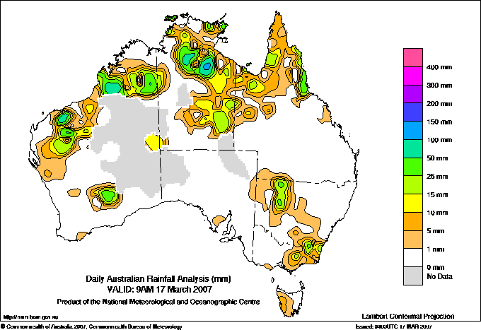
Todays highest rainfall totals for the 24 hours to 9am. It
includes the top 5 totals nationally followed by all reported falls of 50mm or more. |
Highest
and lowest recordings of hours of sunshine for the 24 hours to midnight. |
Highest wind
run totals in kilometres for the 24 hours to 9am (average speed in brackets).
All reported runs >
=25km/h are shown. |
Highest wind
gusts in km/h for the 24 hours to midnight followed by the hour in which it occurred.
All stations with gusts >
89km/h are shown. |
107.0 STIRLING N Coast--Herbert QLD
98.2 TANUMBIRINI N Rivers NT
76.0 HAPPY VALLEY N Coast--Barron QLD
74.0 TREE HOUSE CREEK N Coast--Barron QLD
73.2 WILCANNIA (MOUNT MURCHISON) Far Northwest NSW
WESTERN AUSTRALIA
E Kimberley
57.0 SOPHIE DOWNS
W Kimberley
68.0 BEEFWOOD PARK
64.2 DAMPIER DOWNS
62.2 NERRIMA
W Pilbara
65.0 MOUNT FLORANCE
E Gascoyne
69.6 PARABURDOO AERO
NORTHERN TERRITORY
N Rivers
98.2 TANUMBIRINI
69.5 LARRIMAH
68.2 GILNOCKIE
65.8 PIRLANGIMPI
64.2 DUNDEE BEACH SCHOOL
QUEENSLAND
N Peninsula
52.0 HEATHLANDS NATIONAL PARK
S Peninsula
55.0 HICKS ISLAND
Gulf Country
53.8 MORNINGTON ISLAND
N Coast--Barron
76.0 HAPPY VALLEY
74.0 TREE HOUSE CREEK
64.0 GRAHAM RANGE
59.0 BABINDA POST OFFICE
55.0 MT SOPHIA
53.0 DEERAL
52.0 TOPAZ
N Coast--Herbert
107.0 STIRLING
57.6 DARADGEE
57.4 BAMBAROO
NEW SOUTH WALES
Far Northwest
73.2 WILCANNIA (MOUNT MURCHISON)
SW Slopes S
57.6 CABRAMURRA SMHEA AWS
|
11.6 MOREE AERO NW Plains E NSW
11.5 COFFS HARBOUR MO MidNorth Coast N NSW
11.4 ALBANY AIRPORT Lower West WA
11.3 NURIOOTPA VITICULTURAL Adelaide/Lofty SA
11.2 BRISBANE AERO Brisbane/SE Coast QLD
.....
2.4 STRATHGORDON VILLAGE W Coast TAS
1.7 GOVE AIRPORT N Rivers NT
1.4 COBAR MO Upper Darling NSW
0.3 GILES METEOROLOGICAL OFFICE Interior WA
0.0 WARWICK Darling Downs E QLD
|
1144 (47.7) MAATSUYKER ISLAND LIGHTHOUSE Southeast TAS
1012 (42.2) THREDBO AWS Snowy Mtns NSW
993 (41.4) CAPE GRIM BAPS N Coast TAS
985 (41.0) HOGAN ISLAND Islands ISL
956 (39.8) WILSONS PROMONTORY LIGHTHOUSE W Gippsland VIC
938 (39.1) FLINDERS ISLAND AIRPORT Flinders Is/Bass St TAS
880 (36.7) LOW HEAD N Coast TAS
836 (34.8) MOUNT WELLINGTON Southeast TAS
835 (34.8) CAPE LEEUWIN Lower West WA
770 (32.1) HARTZ MOUNTAIN (KEOGHS PIMPLE) Southeast TAS
757 (31.5) MOUNT READ W Coast TAS
736 (30.7) MONTAGUE ISLAND LIGHTHOUSE South Coast NSW
723 (30.1) HAMILTON ISLAND AIRPORT Central Coast E QLD
702 (29.3) CAPE BRUNY (CAPE BRUNY) Southeast TAS
699 (29.1) WILLIS ISLAND Islands ISL
688 (28.7) OODNADATTA AIRPORT NE Pastoral SA
685 (28.5) SCOTTS PEAK DAM W Coast TAS
656 (27.3) GREEN CAPE AWS South Coast NSW
652 (27.2) MARREE AERO NE Pastoral SA
642 (26.8) FALLS CREEK Upper NE VIC
641 (26.7) PERTH AIRPORT Lower West WA
637 (26.5) MT HOTHAM Upper NE VIC
626 (26.1) RUNDLE ISLAND Wide Bay/Burnett QLD
624 (26.0) ROTTNEST ISLAND Lower West WA
603 (25.1) WOOMERA AERODROME NW Pastoral SA
|
83/06 WILSONS PROMONTORY LIGHTHOUSE W Gippsland VIC
78/12 MOUNT WELLINGTON Southeast TAS
74/01 CABRAMURRA SMHEA AWS SW Slopes S NSW
74/13 TASMAN ISLAND Southeast TAS
72/00 MAATSUYKER ISLAND LIGHTHOUSE Southeast TAS
72/07 HOGAN ISLAND Islands ISL
|
�