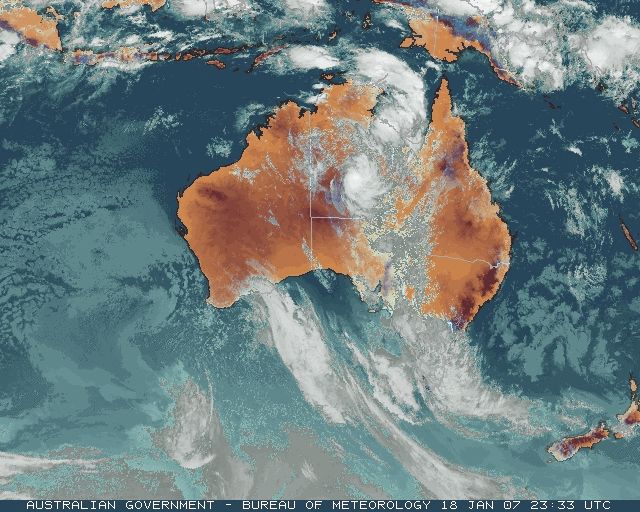
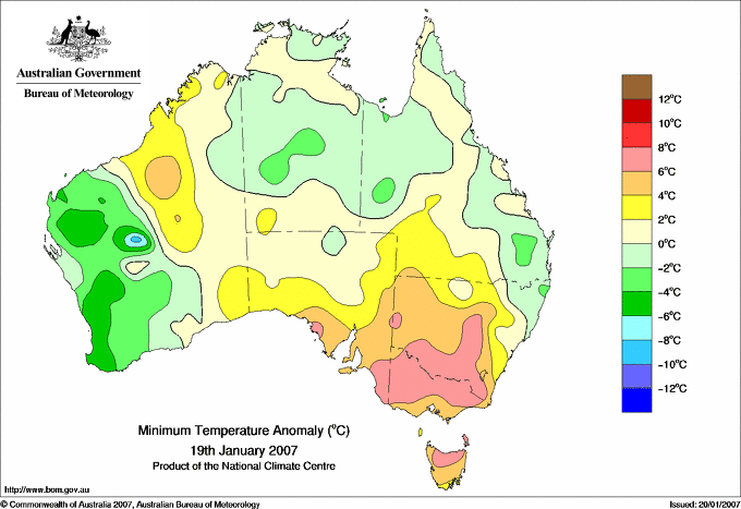
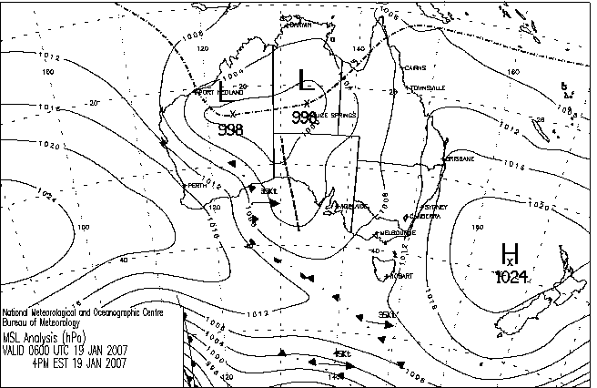
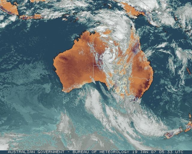
|
For notes on how to interpret
the data and quality control issues, see Daily Weather Summary Help.
**S** and **W** precede data flagged by the Bureau as suspicious or wrong
Data is as received at 23:57EST, 14/05/2012.
|
|
| |
Max
°
C |
+/- norm
°
C |
Min
°
C |
+/- norm
°
C |
Grass Min
°
C |
Rain to 9am mm |
Evaporation to 9am mm |
Sunshine hours |
Wind Run to 9am km (24-hour average km/h) |
Maximum Gust km/h / hour of occurrence |
| GERALDTON AIRPORT |
26.4 |
-5.2 |
17.0 |
-1.3 |
16.6 |
0.0 |
13.4 |
-- |
982 (40.9) |
67/17 |
| PERTH AIRPORT |
25.5 |
-6.1 |
9.1 |
-7.8 |
7.7 |
0.0 |
8.6 |
13.2 |
605 (25.2) |
52/17 |
| ALBANY AIRPORT |
19.1 |
-5.6 |
10.2 |
-3.5 |
7.6 |
4.6 |
4.4 |
12.8 |
275 (11.5) |
43/12 |
| BUNBURY |
23.5 |
-5.9 |
9.7 |
-5.4 |
-- |
0.0 |
-- |
-- |
297 (12.4) |
52/17 |
| MANDURAH |
22.1 |
-- |
15.1 |
-- |
-- |
0.0 |
-- |
-- |
505 (21.0) |
52/13 |
| DARWIN AIRPORT |
31.5 |
-0.3 |
25.4 |
+0.6 |
24.8 |
5.4 |
7.4 |
5.7 |
-- |
52/14 |
| ALICE SPRINGS AIRPORT |
26.6 |
-9.8 |
22.2 |
+0.8 |
22.2 |
52.4 |
9.8 |
0.3 |
327 (13.6) |
35/08 |
| WHYALLA AERO |
30.9 |
+1.0 |
21.2 |
+3.8 |
-- |
36.0 |
14.6 |
-- |
159 ( 6.6) |
55/15 |
| ADELAIDE (KENT TOWN) |
27.1 |
-2.0 |
21.6 |
+4.6 |
17.9 |
2.2 |
2.4 |
0.2 |
228 ( 9.5) |
39/08 |
| MOUNT GAMBIER AERO |
26.6 |
+1.4 |
19.0 |
+7.9 |
18.9 |
2.8 |
5.6 |
0.1 |
254 (10.6) |
32/11 |
| MOUNT ISA AERO |
31.4 |
-4.9 |
23.7 |
-0.1 |
22.5 |
0.2 |
4.2 |
6.4 |
486 (20.3) |
48/18 |
| CAIRNS AERO |
32.5 |
+1.1 |
23.5 |
-0.2 |
22.3 |
3.6 |
6.4 |
10.1 |
355 (14.8) |
34/13 |
| TOWNSVILLE AERO |
32.6 |
+1.3 |
24.2 |
0.0 |
22.6 |
2.4 |
6.8 |
10.1 |
414 (17.3) |
39/12 |
| MACKAY M.O |
28.7 |
-1.4 |
24.9 |
+1.4 |
-- |
0.8 |
-- |
1.9 |
437 (18.2) |
52/20 |
| ROCKHAMPTON AERO |
31.4 |
-0.5 |
23.3 |
+1.2 |
23.2 |
0.0 |
8.0 |
-- |
439 (18.3) |
39/20 |
| BUNDABERG AERO |
31.0 |
+0.9 |
19.8 |
-1.6 |
-- |
0.0 |
7.1 |
-- |
471 (19.6) |
41/12 |
| NAMBOUR DPI |
28.0 |
-1.3 |
18.8 |
-0.6 |
-- |
0.4 |
5.0 |
-- |
107 ( 4.5) |
30/11 |
| COOLANGATTA |
28.6 |
+0.5 |
17.9 |
-3.1 |
-- |
0.4 |
-- |
-- |
260 (10.8) |
34/12 |
| BRISBANE AERO |
28.3 |
-0.7 |
20.6 |
-0.5 |
18.8 |
0.0 |
9.8 |
6.2 |
388 (16.2) |
35/15 |
| TOOWOOMBA AIRPORT |
26.7 |
-1.4 |
16.8 |
-0.7 |
-- |
0.0 |
-- |
-- |
641 (26.7) |
48/15 |
| GUNNEDAH RESOURCE CENTRE |
35.6 |
+3.7 |
22.2 |
+3.4 |
14.3 |
0.0 |
10.6 |
-- |
162 ( 6.8) |
-- |
| COFFS HARBOUR MO |
27.2 |
+0.3 |
16.6 |
-2.8 |
13.6 |
0.0 |
6.6 |
9.9 |
383 (16.0) |
39/15 |
| PORT MACQUARIE AIRPORT AWS |
27.6 |
+0.2 |
19.5 |
+1.4 |
-- |
0.0 |
-- |
-- |
-- |
-- |
| WILLIAMTOWN RAAF |
31.5 |
+3.6 |
20.0 |
+2.0 |
16.2 |
0.0 |
11.0 |
13.2 |
514 (21.4) |
48/16 |
| GOSFORD (NARARA RESEARCH STATION) AWS |
28.7 |
+1.2 |
-- |
-- |
-- |
-- |
-- |
-- |
-- |
30/13 |
| ORANGE AGRICULTURAL INSTITUTE |
31.0 |
+4.5 |
15.8 |
+2.6 |
13.0 |
19.8 |
13.0 |
13.1 |
-- |
-- |
| DUBBO AIRPORT AWS |
36.0 |
+2.9 |
23.1 |
+5.0 |
-- |
0.0 |
-- |
-- |
-- |
-- |
| SYDNEY AIRPORT AMO |
29.2 |
+2.8 |
21.4 |
+2.7 |
19.3 |
0.0 |
11.0 |
12.0 |
664 (27.7) |
59/17 |
| RICHMOND RAAF |
34.2 |
+4.4 |
21.0 |
+3.6 |
-- |
0.0 |
-- |
-- |
215 ( 9.0) |
34/16 |
| BELLAMBI AWS |
23.8 |
-1.0 |
18.3 |
-0.6 |
-- |
0.0 |
-- |
-- |
424 (17.7) |
44/10 |
| CANBERRA AIRPORT |
35.3 |
+7.3 |
17.7 |
+4.5 |
15.6 |
3.2 |
7.2 |
12.6 |
271 (11.3) |
39/20 |
| WAGGA WAGGA AMO |
36.3 |
+4.7 |
21.7 |
+5.5 |
21.7 |
10.4 |
9.4 |
7.4 |
361 (15.0) |
39/15 |
| ALBURY AIRPORT AWS |
34.0 |
+1.8 |
22.2 |
+5.6 |
-- |
2.6 |
-- |
-- |
195 ( 8.1) |
43/23 |
| MILDURA AIRPORT |
36.5 |
+4.3 |
22.4 |
+5.8 |
22.0 |
11.0 |
9.6 |
4.3 |
325 (13.5) |
43/16 |
| TATURA INST SUSTAINABLE AG |
34.0 |
+4.5 |
20.4 |
+6.3 |
-- |
1.0 |
4.2 |
-- |
224 ( 9.3) |
34/12 |
| BENDIGO AIRPORT |
30.4 |
+0.9 |
21.7 |
+7.8 |
-- |
1.0 |
-- |
-- |
219 ( 9.1) |
�
26/13 |
| MELBOURNE REGIONAL OFFICE |
29.8 |
+3.9 |
19.5 |
+5.2 |
19.0 |
7.2 |
4.0 |
-- |
133 ( 5.5) |
21/18 |
| GEELONG AIRPORT |
26.9 |
+2.3 |
17.4 |
+4.3 |
-- |
1.2 |
-- |
-- |
207 ( 8.6) |
21/15 |
| BALLARAT AERODROME |
27.8 |
+2.8 |
18.5 |
+7.7 |
-- |
9.8 |
-- |
-- |
338 (14.1) |
43/22 |
| LAUNCESTON (TI TREE BEND) |
25.4 |
+1.2 |
19.1 |
+7.0 |
-- |
0.0 |
-- |
-- |
226 ( 9.4) |
24/16 |
| HOBART AIRPORT |
24.9 |
+2.4 |
15.2 |
+3.2 |
13.2 |
0.0 |
4.0 |
0.4 |
354 (14.8) |
41/16 |
| |
Max
°
C |
+/- norm
°
C |
Min
°
C |
+/- norm
°
C |
Grass Min
°
C |
Rain to 9am mm |
Evaporation to 9am mm |
Sunshine hours |
Wind Run to 9am km |
Maximum Gust km/h / hour of occurrence |
|
| Hottest |
| Highest maximum temperature> | Greatest variation above normal maximum |
Highest minimum temperature | Greatest variation above normal minimum |
44.5 MARBLE BAR E Pilbara WA
43.9 TELFER AERO Interior WA
42.7 NEWMAN AERO E Gascoyne WA
42.6 WITTENOOM W Pilbara WA
41.3 CARNEGIE Interior WA
|
+12.6 : 38.4 EUCLA Eucla WA
+10.6 : 38.5 NULLARBOR W Agricultural SA
+8.1 : 34.0 TARALGA POST OFFICE Goulburn/Monaro NSW
+7.6 : 37.0 BURRINJUCK DAM SW Slopes N NSW
+7.3 : 35.3 CANBERRA AIRPORT Goulburn/Monaro NSW
|
30.0 TELFER AERO Interior WA
30.0 NORTHERN ENDEAVOUR Islands ISL
29.6 THARGOMINDAH AIRPORT Far SW QLD
28.9 BROOME AIRPORT W Kimberley WA
28.9 BIDYADANGA W Kimberley WA
|
+9.5 : 21.0 NARACOORTE AERODROME Lower SE SA
+9.5 : 19.1 OMEO COMPARISON Upper NE VIC
+8.9 : 22.7 RUTHERGLEN RESEARCH Lower NE VIC
+8.9 : 18.9 CRESSY RESEARCH STATION N Coast TAS
+8.7 : 22.8 WANGARATTA AERO Lower NE VIC
|
| Coldest |
| Lowest maximum temperature | Greatest variation below normal maximum |
Lowest minimum temperature | Greatest variation below normal minimum |
17.3 MOUNT READ W Coast TAS
17.7 MT HOTHAM Upper NE VIC
17.9 MAATSUYKER ISLAND LIGHTHOUSE Southeast TAS
18.0 ALBANY Lower West WA
19.0 NORTH WALPOLE Lower West WA
|
-10.4 : 22.1 NORSEMAN Goldfields WA
-9.8 : 26.6 ALICE SPRINGS AIRPORT N Plateau NT
-9.7 : 22.4 NORSEMAN AERO Goldfields WA
-9.6 : 20.8 SALMON GUMS RES.STN. Goldfields WA
-9.4 : 27.8 PAYNES FIND E Gascoyne WA
-9.4 : 19.5 RAVENSTHORPE Cent Wheatbelt WA
-9.4 : 28.1 TERRITORY GRAPE FARM N Plateau NT
|
6.0 BRIDGETOWN Lower West WA
6.3 JARRAHWOOD Lower West WA
7.0 BRIDGETOWN COMPARISON Lower West WA
7.0 BUSSELTON AERO Lower West WA
7.6 COLLIE EAST Lower West WA
|
-7.8 : 9.1 PERTH AIRPORT Lower West WA
-7.0 : 7.0 BUSSELTON AERO Lower West WA
-6.8 : 6.0 BRIDGETOWN Lower West WA
-6.8 : 16.0 WILUNA Interior WA
-6.6 : 16.6 MOUNT MAGNET AERO E Gascoyne WA
-6.6 : 10.3 PEARCE RAAF Lower West WA
|
|
Sunniest &
dullest |
Windiest |
Highest gusts |
Todays highest rainfall totals for the 24 hours to 9am. It
includes the top 5 totals nationally followed by all reported falls of 50mm or more. |
Highest
and lowest recordings of hours of sunshine for the 24 hours to midnight. |
Highest wind
run totals in kilometres for the 24 hours to 9am (average speed in brackets).
All reported runs >
=25km/h are shown. |
Highest wind
gusts in km/h for the 24 hours to midnight followed by the hour in which it occurred.
All stations with gusts >
89km/h are shown. |
145.6 WOODGREEN N Plateau NT
112.0 BARKLY HOMESTEAD N Plateau NT
95.0 WAITE RIVER N Plateau NT
78.4 TENNANT CREEK AIRPORT N Plateau NT
75.0 ARCHER RIVER ROADHOUSE N Peninsula QLD
WESTERN AUSTRALIA
W Kimberley
62.8 BEAGLE BAY
54.0 CHERRABUN
NORTHERN TERRITORY
N Rivers
70.0 BING BONG PORT
N Plateau
145.6 WOODGREEN
112.0 BARKLY HOMESTEAD
95.0 WAITE RIVER
78.4 TENNANT CREEK AIRPORT
70.0 WARRAMUNGA
64.0 HELEN SPRINGS
59.8 MURRAY DOWNS
55.8 EPENARRA
54.8 RENNER SPRINGS
54.5 AMMAROO
53.0 THREEWAYS ROADHOUSE
52.4 ALICE SPRINGS AIRPORT
51.0 NEUTRAL JUNCTION
SOUTH AUSTRALIA
NW Pastoral
69.0 PORT AUGUSTA (YUDNAPINNA)
68.0 KINGOONYA (NORTH WELL)
66.0 NONNING
64.8 TARCOOLA (COMMONWEALTH HILL)
62.2 TARCOOLA AERO
61.3 MOUNT EBA
57.0 GLENDAMBO
55.6 TARCOOLA (MULGATHING)
55.0 MOONAREE
54.2 COOBER PEDY (MCDOUALL PEAK)
W Agricultural
60.6 ROOPENA
55.6 IRON KNOB
55.0 IRON KNOB (GILLES DOWNS)
54.0 GAWLER RANGES (SIAM)
Upper North
57.6 OODLA WIRRA
50.8 ORROROO (BLACK ROCK)
Lower North
53.8 WHYTE-YARCOWIE (GUM PARK)
50.0 BURRA (POONUNDA)
QUEENSLAND
N Peninsula
75.0 ARCHER RIVER ROADHOUSE
55.0 PICCANINNY PLAINS STATION
Gulf Country
72.6 KARUMBA AIRPORT
59.0 ESCOTT STATION
N Coast--Herbert
64.0 HALIFAX ALERT
62.7 MACKNADE SUGAR MILL
58.6 LUCINDA POST OFFICE
NEW SOUTH WALES
C Tablelands S
52.0 TRUNKEY (OLD POST OFFICE)
Goulburn/Monaro
72.0 ROCK FLAT (OLD POST OFFICE)
VICTORIA
Wimmera N
51.6 NHILL
TASMANIA
N Coast
50.0 SPRINGFIELD
|
13.2 PERTH AIRPORT Lower West WA
13.2 MOREE AERO NW Plains E NSW
13.2 WILLIAMTOWN RAAF Hunter Valley NSW
13.1 ORANGE AGRICULTURAL INSTITUTE C Tablelands S NSW
12.8 ALBANY AIRPORT Lower West WA
.....
0.1 MOUNT GAMBIER AERO Lower SE SA
0.1 BUNDOORA (LATROBE UNIVERSITY) E Central VIC
0.1 SCOTTSDALE (WEST MINSTONE ROAD) N Coast TAS
0.1 LAKE LEAKE (ELIZABETH RIVER) E Coast TAS
0.1 EAST SALE AIRPORT W Gippsland VIC
0.0 WARWICK Darling Downs E QLD
0.0 BICHENO (COUNCIL DEPOT) E Coast TAS
|
996 (41.5) CARNARVON AIRPORT W Gascoyne WA
982 (40.9) GERALDTON AIRPORT Central West WA
915 (38.1) ROTTNEST ISLAND Lower West WA
884 (36.8) NORTH ISLAND Central West WA
857 (35.7) RUNDLE ISLAND Wide Bay/Burnett QLD
848 (35.3) SHARK BAY AIRPORT W Gascoyne WA
818 (34.1) VARANUS ISLAND Islands ISL
804 (33.5) HAMILTON ISLAND AIRPORT Central Coast E QLD
799 (33.3) CAPE GRIM BAPS N Coast TAS
764 (31.8) LEARMONTH AIRPORT W Pilbara WA
748 (31.2) MONTAGUE ISLAND LIGHTHOUSE South Coast NSW
747 (31.1) GARDEN ISLAND HSF Lower West WA
745 (31.0) KARRATHA AERO E Pilbara WA
745 (31.0) THEVENARD ISLAND W Pilbara WA
742 (30.9) BARROW ISLAND AIRPORT W Pilbara WA
733 (30.5) GREEN CAPE AWS South Coast NSW
702 (29.3) BIRDSVILLE AIRPORT Channel Country QLD
699 (29.1) LADY ELLIOT ISLAND Wide Bay/Burnett QLD
693 (28.9) MCCLUER ISLAND N Rivers NT
685 (28.5) DOUBLE ISLAND POINT LIGHTHOUSE Brisbane/SE Coast QLD
680 (28.3) POINT FAWCETT Islands ISL
664 (27.7) SYDNEY AIRPORT AMO Sydney--east NSW
657 (27.4) HERON ISLAND RES STN Wide Bay/Burnett QLD
655 (27.3) ONSLOW AIRPORT W Pilbara WA
653 (27.2) CAPE MORETON LIGHTHOUSE Brisbane/SE Coast QLD
644 (26.8) LORD HOWE ISLAND AERO Islands ISL
641 (26.7) TOOWOOMBA AIRPORT Darling Downs E QLD
605 (25.2) PERTH AIRPORT Lower West WA
604 (25.2) GLADSTONE RADAR Wide Bay/Burnett QLD
|
81/22 CENTRE ISLAND N Rivers NT
76/14 FORREST Eucla WA
76/19 NULLARBOR W Agricultural SA
76/15 KEITH (MUNKORA) Mallee/Upper SE SA
74/21 HAMILTON ISLAND AIRPORT Central Coast E QLD
74/03 THREDBO AWS Snowy Mtns NSW
|
�