|
For notes on how to interpret
the data and quality control issues, see Daily Weather Summary Help.
**S** and **W** precede data flagged by the Bureau as suspicious or wrong
Data is as received at 23:58EST, 14/05/2012.
|
|
| |
Max
°
C |
+/- norm
°
C |
Min
°
C |
+/- norm
°
C |
Grass Min
°
C |
Rain to 9am mm |
Evaporation to 9am mm |
Sunshine hours |
Wind Run to 9am km (24-hour average km/h) |
Maximum Gust km/h / hour of occurrence |
| GERALDTON AIRPORT |
27.4 |
-4.2 |
20.0 |
+1.7 |
19.0 |
0.0 |
9.0 |
-- |
525 (21.9) |
43/18 |
| PERTH AIRPORT |
32.3 |
+0.7 |
16.9 |
0.0 |
14.6 |
0.0 |
8.8 |
11.8 |
360 (15.0) |
39/18 |
| ALBANY AIRPORT |
22.7 |
-2.0 |
13.8 |
+0.1 |
10.3 |
0.0 |
6.6 |
10.9 |
456 (19.0) |
45/14 |
| BUNBURY |
30.4 |
+1.0 |
14.9 |
-0.2 |
-- |
0.0 |
-- |
-- |
298 (12.4) |
39/18 |
| MANDURAH |
27.4 |
-- |
18.5 |
-- |
-- |
0.0 |
-- |
-- |
367 (15.3) |
43/15 |
| DARWIN AIRPORT |
30.9 |
-0.9 |
25.5 |
+0.7 |
25.4 |
0.6 |
6.2 |
0.0 |
393 (16.4) |
39/14 |
| ALICE SPRINGS AIRPORT |
32.5 |
-3.9 |
23.0 |
+1.6 |
21.1 |
0.0 |
10.8 |
3.3 |
331 (13.8) |
37/13 |
| WHYALLA AERO |
28.1 |
-1.8 |
17.8 |
+0.4 |
-- |
0.0 |
8.0 |
-- |
409 (17.0) |
39/18 |
| ADELAIDE (KENT TOWN) |
29.6 |
+0.5 |
13.8 |
-3.2 |
7.7 |
0.0 |
7.6 |
13.2 |
209 ( 8.7) |
35/16 |
| MOUNT GAMBIER AERO |
22.5 |
-2.7 |
14.2 |
+3.1 |
11.3 |
0.0 |
5.2 |
11.2 |
343 (14.3) |
41/18 |
| MOUNT ISA AERO |
32.7 |
-3.6 |
23.5 |
-0.3 |
23.0 |
2.8 |
1.8 |
3.9 |
200 ( 8.3) |
32/18 |
| CAIRNS AERO |
32.3 |
+0.9 |
25.5 |
+1.8 |
23.8 |
0.0 |
6.6 |
7.7 |
279 (11.6) |
28/16 |
| TOWNSVILLE AERO |
30.9 |
-0.4 |
25.5 |
+1.3 |
25.0 |
6.4 |
6.0 |
6.1 |
398 (16.6) |
39/15 |
| MACKAY M.O |
31.1 |
+1.0 |
23.1 |
-0.4 |
-- |
127.0 |
-- |
3.5 |
339 (14.1) |
32/01 |
| ROCKHAMPTON AERO |
33.2 |
+1.3 |
24.7 |
+2.6 |
24.4 |
1.0 |
5.0 |
-- |
295 (12.3) |
35/15 |
| BUNDABERG AERO |
33.3 |
+3.2 |
24.6 |
+3.2 |
-- |
0.0 |
8.8 |
-- |
303 (12.6) |
37/14 |
| NAMBOUR DPI |
32.2 |
+2.9 |
21.5 |
+2.1 |
-- |
0.0 |
6.4 |
-- |
99 ( 4.1) |
24/13 |
| COOLANGATTA |
30.4 |
+2.3 |
23.1 |
+2.1 |
-- |
0.0 |
-- |
-- |
313 (13.0) |
37/12 |
| BRISBANE AERO |
31.4 |
+2.4 |
23.9 |
+2.8 |
22.7 |
10.6 |
9.8 |
9.4 |
435 (18.1) |
48/15 |
| TOOWOOMBA AIRPORT |
30.9 |
+2.8 |
20.5 |
+3.0 |
-- |
0.0 |
-- |
-- |
411 (17.1) |
45/19 |
| GUNNEDAH RESOURCE CENTRE |
32.1 |
+0.2 |
21.3 |
+2.5 |
16.6 |
11.8 |
8.4 |
-- |
206 ( 8.6) |
-- |
| COFFS HARBOUR MO |
29.7 |
+2.8 |
20.8 |
+1.4 |
18.2 |
0.0 |
4.6 |
7.0 |
384 (16.0) |
43/15 |
| PORT MACQUARIE AIRPORT AWS |
30.2 |
+2.8 |
21.0 |
+2.9 |
-- |
0.0 |
-- |
-- |
-- |
-- |
| WILLIAMTOWN RAAF |
24.8 |
-3.1 |
21.8 |
+3.8 |
21.5 |
1.2 |
5.4 |
0.8 |
369 (15.4) |
37/09 |
| GOSFORD (NARARA RESEARCH STATION) AWS |
24.0 |
-3.5 |
21.3 |
+4.6 |
-- |
26.2 |
-- |
-- |
168 ( 7.0) |
26/00 |
| ORANGE AGRICULTURAL INSTITUTE |
25.8 |
-0.7 |
16.6 |
+3.4 |
15.0 |
41.0 |
10.0 |
7.2 |
-- |
-- |
| DUBBO AIRPORT AWS |
29.6 |
-3.5 |
22.3 |
+4.2 |
-- |
4.0 |
-- |
-- |
-- |
-- |
| SYDNEY AIRPORT AMO |
23.5 |
-2.9 |
22.4 |
+3.7 |
20.9 |
2.0 |
7.4 |
1.6 |
540 (22.5) |
45/16 |
| RICHMOND RAAF |
26.7 |
-3.1 |
20.9 |
+3.5 |
-- |
21.8 |
-- |
-- |
262 (10.9) |
31/17 |
| BELLAMBI AWS |
22.5 |
-2.3 |
19.7 |
+0.8 |
-- |
2.0 |
-- |
-- |
475 (19.8) |
63/00 |
| CANBERRA AIRPORT |
33.1 |
+5.1 |
17.6 |
+4.4 |
16.2 |
2.8 |
12.2 |
12.2 |
345 (14.4) |
52/17 |
| WAGGA WAGGA AMO |
33.5 |
+1.9 |
20.3 |
+4.1 |
18.8 |
2.2 |
10.6 |
13.4 |
295 (12.3) |
50/00 |
| ALBURY AIRPORT AWS |
32.5 |
+0.3 |
17.5 |
+0.9 |
-- |
0.0 |
-- |
-- |
215 ( 9.0) |
39/11 |
| MILDURA AIRPORT |
29.9 |
-2.3 |
16.5 |
-0.1 |
15.2 |
0.0 |
10.4 |
13.4 |
316 (13.2) |
35/15 |
| TATURA INST SUSTAINABLE AG |
26.5 |
-3.0 |
14.6 |
+0.5 |
-- |
0.0 |
9.0 |
-- |
354 (14.8) |
43/14 |
| BENDIGO AIRPORT |
27.4 |
-2.1 |
12.4 |
-1.5 |
-- |
0.0 |
-- |
-- |
344 (14.3) |
�
39/14 |
| MELBOURNE REGIONAL OFFICE |
23.0 |
-2.9 |
16.8 |
+2.5 |
14.9 |
0.0 |
5.6 |
-- |
123 ( 5.1) |
21/12 |
| GEELONG AIRPORT |
20.6 |
-4.0 |
13.6 |
+0.5 |
-- |
0.0 |
-- |
-- |
287 (12.0) |
43/14 |
| BALLARAT AERODROME |
21.6 |
-3.4 |
12.1 |
+1.3 |
-- |
0.0 |
-- |
-- |
387 (16.1) |
35/15 |
| LAUNCESTON (TI TREE BEND) |
24.1 |
-0.1 |
12.1 |
0.0 |
-- |
0.0 |
-- |
-- |
334 (13.9) |
43/17 |
| HOBART AIRPORT |
20.1 |
-2.4 |
12.5 |
+0.5 |
9.9 |
0.0 |
4.4 |
10.4 |
410 (17.1) |
54/00 |
| |
Max
°
C |
+/- norm
°
C |
Min
°
C |
+/- norm
°
C |
Grass Min
°
C |
Rain to 9am mm |
Evaporation to 9am mm |
Sunshine hours |
Wind Run to 9am km |
Maximum Gust km/h / hour of occurrence |
|
| Hottest |
| Highest maximum temperature> | Greatest variation above normal maximum |
Highest minimum temperature | Greatest variation above normal minimum |
45.5 MARBLE BAR E Pilbara WA
44.7 TELFER AERO Interior WA
44.3 EYRE Eucla WA
43.5 PARDOO STATION E Pilbara WA
43.3 PARABURDOO AERO E Gascoyne WA
|
+18.0 : 44.3 EYRE Eucla WA
+13.7 : 39.5 EUCLA Eucla WA
+9.5 : 42.5 BALGAIR Eucla WA
+8.9 : 36.8 NULLARBOR W Agricultural SA
+8.9 : 41.8 FORREST Eucla WA
|
31.3 MARBLE BAR E Pilbara WA
30.9 NEWMAN AERO E Gascoyne WA
29.4 WITTENOOM W Pilbara WA
28.8 POINT FAWCETT Islands ISL
28.3 LAVERTON AERO Goldfields WA
|
+8.0 : 24.3 BALGAIR Eucla WA
+7.1 : 28.3 LAVERTON AERO Goldfields WA
+7.0 : 19.6 GOULBURN AIRPORT AWS Goulburn/Monaro NSW
+6.9 : 19.0 TIDBINBILLA NATURE RESERVE Goulburn/Monaro NSW
+6.2 : 22.7 CESSNOCK AIRPORT AWS Hunter Valley NSW
+6.2 : 18.0 TARALGA POST OFFICE Goulburn/Monaro NSW
|
| Coldest |
| Lowest maximum temperature | Greatest variation below normal maximum |
Lowest minimum temperature | Greatest variation below normal minimum |
8.1 MOUNT READ W Coast TAS
9.0 MOUNT WELLINGTON Southeast TAS
10.2 MT BAW BAW W Gippsland VIC
10.9 HARTZ MOUNTAIN (KEOGHS PIMPLE) Southeast TAS
13.0 WARRA W Coast TAS
|
-7.5 : 30.2 TIBOOBURRA AIRPORT Far Northwest NSW
-7.5 : 10.2 MT BAW BAW W Gippsland VIC
-7.3 : 31.0 THARGOMINDAH AIRPORT Far SW QLD
-7.1 : 31.8 BEDOURIE POLICE STATION Channel Country QLD
-7.0 : 10.9 HARTZ MOUNTAIN (KEOGHS PIMPLE) Southeast TAS
|
2.1 MOUNT WELLINGTON Southeast TAS
3.3 MOUNT READ W Coast TAS
4.7 HARTZ MOUNTAIN (KEOGHS PIMPLE) Southeast TAS
5.1 MT BAW BAW W Gippsland VIC
6.6 LAKE ST CLAIR NATIONAL PARK Central Plateau TAS
|
-5.7 : 18.4 RABBIT FLAT N Plateau NT
-4.6 : 10.1 CLARE HIGH SCHOOL Lower North SA
-4.3 : 10.8 CEDUNA AMO W Agricultural SA
-4.0 : 20.0 LAJAMANU N Rivers NT
-3.9 : 11.7 ELLISTON W Agricultural SA
-3.9 : 20.2 ELLIOTT N Plateau NT
|
|
Sunniest &
dullest |
Windiest |
Highest gusts |
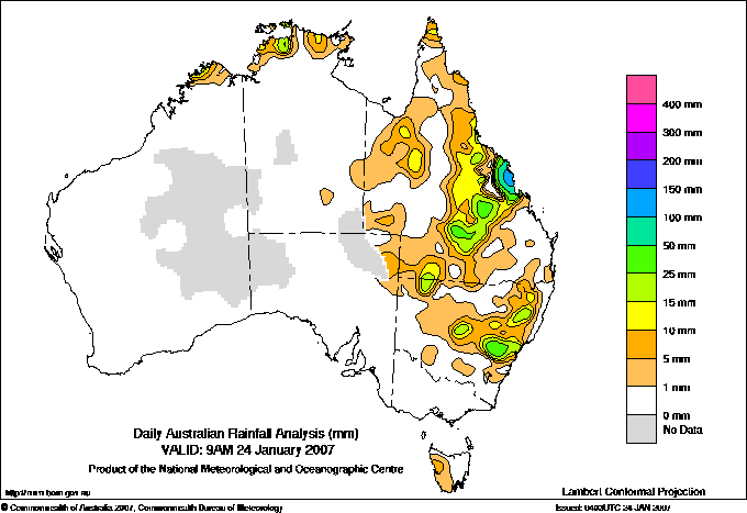
Todays highest rainfall totals for the 24 hours to 9am. It
includes the top 5 totals nationally followed by all reported falls of 50mm or more. |
Highest
and lowest recordings of hours of sunshine for the 24 hours to midnight. |
Highest wind
run totals in kilometres for the 24 hours to 9am (average speed in brackets).
All reported runs >
=25km/h are shown. |
Highest wind
gusts in km/h for the 24 hours to midnight followed by the hour in which it occurred.
All stations with gusts >
89km/h are shown. |
236.2 BELGAMBA Central Coast E QLD
168.0 PLANE CREEK SUGAR MILL Central Coast E QLD
165.0 KOUMALA HATFIELDS ROAD Central Coast E QLD
155.0 MYSTERY PARK Central Coast E QLD
144.0 MOUNT CHARLTON Central Coast E QLD
QUEENSLAND
Gulf Country
77.0 LAWN HILL
N Coast--Herbert
109.4 YABULU QLD NICKEL
86.0 MENAVALE ALERT
53.6 ORPHEUS ISLAND RESORT
50.0 JAPOONVALE WARRAKIN RD
Central Coast E
236.2 BELGAMBA
168.0 PLANE CREEK SUGAR MILL
165.0 KOUMALA HATFIELDS ROAD
155.0 MYSTERY PARK
144.0 MOUNT CHARLTON
138.0 MACKAY ALERT
136.0 LOWGLEN KARINGAL
132.2 BRAMPTON ISLAND RESORT
130.0 EAST MACKAY
127.0 MACKAY M.O
124.0 MACKAY AERO
120.0 DALRYMPLE HEIGHTS
115.5 STOCKADE NURSERY
115.0 TE KOWAI EXP STN
113.0 EUNGELLA NATIONAL PARK
106.2 DORAVILLE STATION
106.0 ETON STATE WATER DEPOT
105.0 MIRANI WEIR ALERT
104.0 PLEYSTOWE SUGAR MILL
102.0 DUMBLETON ROCKS ALERT
102.0 BLOOMSBURY
101.0 OWENS CREEK
97.0 CREDITON
96.0 MIRANI WEIR TM
92.0 MIRANI MARY STREET
89.0 GARGETT ALERT
85.4 SEAFORTH
85.0 MOUNT JUKES
76.4 PROSERPINE AIRPORT
74.0 WHITEFORD'S ALERT
67.2 BARNGANAL BLUE MOUNTAIN
65.6 WILSON BEACH
63.4 HAMILTON ISLAND AIRPORT
63.4 ST LAWRENCE
63.2 CRYSTAL BROOK
61.0 LETHEBROOK
60.0 CARDOWAN
60.0 GARGETT POST OFFICE
55.8 HAMILTON ISLAND AIRPORT
54.0 LINDEMAN ISLAND RESORT
51.7 ST LAWRENCE POST OFFICE
50.6 NEBO SHIRE COUNCIL
50.4 HECATE
Central Coast W
60.0 LANDSBOROUGH STATION
50.0 WAITARA
Northwest
60.0 DAGWORTH STATION
Warrego
50.4 BARRADEEN
Far SW
63.0 MILROY
NEW SOUTH WALES
NW Slopes S
53.4 BREEZA (ALPHA)
Hunter Valley
66.0 LOWER MANGROVE (POPRAN RD)
C Tablelands S
53.6 CANOWINDRA (BELUBULA PARK)
53.0 ORANGE AIRPORT AWS
CW Slopes N
64.6 BINNAWAY (HAWTHORNE)
ISLANDS
Islands
59.2 CHRISTMAS ISLAND AERO
|
13.5 ADELAIDE AIRPORT Adelaide/Lofty SA
13.5 NURIOOTPA VITICULTURAL Adelaide/Lofty SA
13.4 CEDUNA AMO W Agricultural SA
13.4 WAGGA WAGGA AMO SW Slopes S NSW
13.4 MILDURA AIRPORT Mallee N VIC
.....
1.6 SYDNEY AIRPORT AMO Sydney--east NSW
1.5 WELLINGTON (AGROWPLOW) CW Slopes S NSW
0.8 WILLIAMTOWN RAAF Hunter Valley NSW
0.0 DARWIN AIRPORT N Rivers NT
0.0 SCONE SCS Hunter Valley NSW
|
1356 (56.5) MAATSUYKER ISLAND LIGHTHOUSE Southeast TAS
907 (37.8) LOW HEAD N Coast TAS
866 (36.1) CAPE LEEUWIN Lower West WA
850 (35.4) VARANUS ISLAND Islands ISL
824 (34.3) SCOTTS PEAK DAM W Coast TAS
810 (33.8) CAPE GRIM BAPS N Coast TAS
772 (32.2) MOUNT WELLINGTON Southeast TAS
759 (31.6) KARRATHA AERO E Pilbara WA
727 (30.3) BARROW ISLAND AIRPORT W Pilbara WA
713 (29.7) SWAN ISLAND E Coast TAS
690 (28.8) DEVONPORT AIRPORT N Coast TAS
681 (28.4) CARNARVON AIRPORT W Gascoyne WA
675 (28.1) FLINDERS ISLAND AIRPORT Flinders Is/Bass St TAS
666 (27.8) MOUNT READ W Coast TAS
658 (27.4) WILSONS PROMONTORY LIGHTHOUSE W Gippsland VIC
655 (27.3) ESPERANCE Lower West WA
650 (27.1) HARTZ MOUNTAIN (KEOGHS PIMPLE) Southeast TAS
646 (26.9) STRAHAN AERODROME W Coast TAS
644 (26.8) THREDBO AWS Snowy Mtns NSW
625 (26.0) HOGAN ISLAND Islands ISL
614 (25.6) THEVENARD ISLAND W Pilbara WA
601 (25.0) MT HOTHAM Upper NE VIC
|
91/02 MOUNT WELLINGTON Southeast TAS
87/02 MAATSUYKER ISLAND LIGHTHOUSE Southeast TAS
78/16 CASINO AIRPORT AWS North Coast NSW
70/00 HARTZ MOUNTAIN (KEOGHS PIMPLE) Southeast TAS
68/18 MOUNT MAGNET AERO E Gascoyne WA
68/06 WILSONS PROMONTORY LIGHTHOUSE W Gippsland VIC
68/17 TASMAN ISLAND Southeast TAS
68/14 CAPE BRUNY (CAPE BRUNY) Southeast TAS
|
�