|
For notes on how to interpret
the data and quality control issues, see Daily Weather Summary Help.
**S** and **W** precede data flagged by the Bureau as suspicious or wrong
Data is as received at 00:29EST, 15/05/2012.
|
|
| |
Max
°
C |
+/- norm
°
C |
Min
°
C |
+/- norm
°
C |
Grass Min
°
C |
Rain to 9am mm |
Evaporation to 9am mm |
Sunshine hours |
Wind Run to 9am km (24-hour average km/h) |
Maximum Gust km/h / hour of occurrence |
| GERALDTON AIRPORT |
24.7 |
-2.9 |
13.4 |
-2.0 |
10.3 |
0.0 |
4.6 |
-- |
360 (15.0) |
50/15 |
| PERTH AIRPORT |
22.6 |
-2.9 |
12.2 |
-0.7 |
10.0 |
0.0 |
3.2 |
6.2 |
288 (12.0) |
58/17 |
| ALBANY AIRPORT |
23.3 |
+1.5 |
11.1 |
-0.5 |
5.9 |
0.0 |
4.8 |
6.8 |
499 (20.8) |
63/10 |
| BUNBURY |
21.9 |
-2.2 |
14.9 |
+3.4 |
-- |
2.0 |
-- |
-- |
481 (20.0) |
80/16 |
| MANDURAH |
21.1 |
-- |
17.1 |
-- |
-- |
1.8 |
-- |
-- |
552 (23.0) |
70/19 |
| DARWIN AIRPORT |
32.2 |
-0.5 |
23.1 |
-0.9 |
22.1 |
0.0 |
5.6 |
10.5 |
269 (11.2) |
32/15 |
| ALICE SPRINGS AIRPORT |
26.5 |
-1.7 |
9.6 |
-3.0 |
6.9 |
0.0 |
6.0 |
11.0 |
206 ( 8.6) |
24/09 |
| WHYALLA AERO |
22.1 |
-1.5 |
14.6 |
+3.0 |
-- |
0.0 |
3.8 |
-- |
504 (21.0) |
48/10 |
| ADELAIDE (KENT TOWN) |
19.3 |
-3.3 |
14.8 |
+2.4 |
14.2 |
0.0 |
-- |
4.6 |
376 (15.7) |
46/13 |
| MOUNT GAMBIER AERO |
18.5 |
-0.9 |
9.0 |
+0.3 |
7.7 |
7.2 |
0.8 |
6.1 |
173 ( 7.2) |
37/14 |
| MOUNT ISA AERO |
32.9 |
+1.0 |
19.0 |
+0.5 |
16.3 |
0.0 |
9.0 |
9.6 |
321 (13.4) |
28/11 |
| CAIRNS AERO |
30.3 |
+1.1 |
18.2 |
-3.4 |
13.4 |
0.0 |
4.4 |
11.0 |
142 ( 5.9) |
22/13 |
| TOWNSVILLE AERO |
30.3 |
+0.7 |
19.5 |
-1.0 |
17.8 |
0.0 |
5.2 |
10.8 |
163 ( 6.8) |
30/12 |
| MACKAY M.O |
30.3 |
+3.6 |
20.0 |
-0.1 |
-- |
0.0 |
-- |
10.6 |
299 (12.5) |
30/12 |
| ROCKHAMPTON AERO |
28.8 |
0.0 |
19.8 |
+2.0 |
19.6 |
1.2 |
6.0 |
-- |
232 ( 9.7) |
22/12 |
| BUNDABERG AERO |
23.7 |
-3.7 |
17.6 |
+0.1 |
-- |
14.6 |
3.6 |
-- |
383 (16.0) |
30/04 |
| NAMBOUR DPI |
25.9 |
-0.2 |
17.7 |
+2.3 |
-- |
0.0 |
-- |
-- |
106 ( 4.4) |
18/16 |
| COOLANGATTA |
26.8 |
+1.5 |
13.5 |
-3.5 |
-- |
0.2 |
-- |
-- |
214 ( 8.9) |
35/13 |
| BRISBANE AERO |
27.7 |
+1.7 |
16.3 |
+0.1 |
13.4 |
0.4 |
4.4 |
9.2 |
352 (14.7) |
34/17 |
| TOOWOOMBA AIRPORT |
21.2 |
-2.2 |
11.1 |
-2.2 |
-- |
8.2 |
-- |
-- |
453 (18.9) |
39/14 |
| GUNNEDAH RESOURCE CENTRE |
22.4 |
-2.7 |
13.3 |
+0.5 |
11.0 |
8.0 |
2.0 |
-- |
243 (10.1) |
-- |
| COFFS HARBOUR MO |
24.8 |
+0.8 |
13.1 |
-2.1 |
10.4 |
0.4 |
1.4 |
10.4 |
346 (14.4) |
32/15 |
| PORT MACQUARIE AIRPORT AWS |
24.8 |
+0.8 |
8.9 |
-4.8 |
-- |
1.0 |
-- |
-- |
-- |
-- |
| WILLIAMTOWN RAAF |
23.9 |
+0.3 |
11.1 |
-2.1 |
8.1 |
0.2 |
3.0 |
10.5 |
374 (15.6) |
61/12 |
| GOSFORD (NARARA RESEARCH STATION) AWS |
24.1 |
+0.5 |
12.7 |
+0.8 |
-- |
0.4 |
-- |
-- |
101 ( 4.2) |
31/13 |
| ORANGE AGRICULTURAL INSTITUTE |
15.0 |
-3.5 |
9.3 |
+2.1 |
8.7 |
10.5 |
3.3 |
4.4 |
-- |
-- |
| DUBBO AIRPORT AWS |
21.4 |
-3.1 |
13.5 |
+3.4 |
-- |
0.4 |
-- |
-- |
-- |
-- |
| SYDNEY AIRPORT AMO |
25.1 |
+2.2 |
13.9 |
-0.2 |
10.5 |
0.2 |
2.4 |
9.8 |
307 (12.8) |
43/11 |
| RICHMOND RAAF |
22.6 |
-1.3 |
9.5 |
-1.8 |
-- |
0.8 |
-- |
-- |
80 ( 3.3) |
48/12 |
| BELLAMBI AWS |
24.2 |
+2.1 |
16.2 |
+0.8 |
-- |
0.8 |
-- |
-- |
244 (10.2) |
61/18 |
| CANBERRA AIRPORT |
18.3 |
-1.7 |
11.8 |
+5.1 |
10.1 |
6.0 |
1.2 |
4.7 |
278 (11.6) |
46/14 |
| WAGGA WAGGA AMO |
16.2 |
-6.3 |
13.9 |
+4.8 |
13.3 |
4.2 |
2.4 |
1.5 |
225 ( 9.4) |
32/11 |
| ALBURY AIRPORT AWS |
17.8 |
-4.6 |
14.4 |
+6.4 |
-- |
11.6 |
-- |
-- |
203 ( 8.5) |
26/09 |
| MILDURA AIRPORT |
20.4 |
-3.1 |
14.1 |
+4.0 |
13.4 |
6.2 |
1.6 |
4.5 |
455 (19.0) |
45/14 |
| TATURA INST SUSTAINABLE AG |
18.7 |
-2.9 |
13.3 |
+5.1 |
-- |
8.8 |
-- |
-- |
348 (14.5) |
37/14 |
| BENDIGO AIRPORT |
18.2 |
-3.0 |
12.8 |
+5.4 |
-- |
13.8 |
-- |
-- |
334 (13.9) |
�
41/03 |
| MELBOURNE REGIONAL OFFICE |
20.3 |
0.0 |
15.0 |
+4.2 |
12.3 |
1.8 |
2.6 |
-- |
148 ( 6.2) |
18/14 |
| GEELONG AIRPORT |
18.7 |
-1.3 |
12.2 |
+2.9 |
-- |
8.2 |
-- |
-- |
125 ( 5.2) |
37/12 |
| BALLARAT AERODROME |
14.5 |
-3.1 |
11.3 |
+3.9 |
-- |
8.0 |
-- |
-- |
453 (18.9) |
34/02 |
| LAUNCESTON (TI TREE BEND) |
18.2 |
-0.7 |
11.2 |
+3.7 |
-- |
0.1 |
-- |
-- |
341 (14.2) |
37/03 |
| HOBART AIRPORT |
15.6 |
-2.5 |
10.8 |
+2.1 |
9.0 |
3.4 |
0.4 |
0.0 |
214 ( 8.9) |
28/15 |
| |
Max
°
C |
+/- norm
°
C |
Min
°
C |
+/- norm
°
C |
Grass Min
°
C |
Rain to 9am mm |
Evaporation to 9am mm |
Sunshine hours |
Wind Run to 9am km |
Maximum Gust km/h / hour of occurrence |
|
| Hottest |
| Highest maximum temperature> | Greatest variation above normal maximum |
Highest minimum temperature | Greatest variation above normal minimum |
38.5 BRADSHAW N Rivers NT
38.3 WYNDHAM AERO N Kimberley WA
37.9 CURTIN AERO W Kimberley WA
37.8 DALY WATERS AWS N Rivers NT
37.8 TIMBER CREEK N Rivers NT
|
+6.8 : 36.0 QUILPIE AIRPORT Far SW QLD
+5.0 : 29.0 EYRE Eucla WA
+4.7 : 31.2 WALKAMIN DPI N Coast--Barron QLD
+4.3 : 36.7 GEORGETOWN POST OFFICE Upper Carpentaria QLD
|
28.0 TROUGHTON ISLAND N Kimberley WA
28.0 NORTHERN ENDEAVOUR Islands ISL
26.9 MCCLUER ISLAND N Rivers NT
26.3 COCONUT ISLAND N Peninsula QLD
26.1 WILLIS ISLAND Islands ISL
|
+7.5 : 12.8 CRESSY RESEARCH STATION N Coast TAS
+7.4 : 14.1 WANGARATTA AERO Lower NE VIC
+6.7 : 12.2 STRATHBOGIE Lower NE VIC
+6.7 : 13.0 BEECHWORTH WOOLSHED Lower NE VIC
+6.6 : 14.6 GLUEPOT RESERVE (GLUEPOT) Northeast SA
+6.6 : 13.7 RUTHERGLEN RESEARCH Lower NE VIC
+6.6 : 11.1 OUSE FIRE STATION Derwent Valley TAS
|
| Coldest |
| Lowest maximum temperature | Greatest variation below normal maximum |
Lowest minimum temperature | Greatest variation below normal minimum |
4.9 THREDBO AWS Snowy Mtns NSW
5.2 MT HOTHAM Upper NE VIC
6.0 MOUNT GININI AWS Goulburn/Monaro NSW
6.2 FALLS CREEK Upper NE VIC
6.7 MOUNT WELLINGTON Southeast TAS
|
-9.4 : 25.5 EMU CREEK STATION W Gascoyne WA
-9.0 : 18.3 ERNABELLA (PUKATJA) NW Pastoral SA
-8.6 : 24.2 GASCOYNE JUNCTION W Gascoyne WA
-8.0 : 25.2 LEARMONTH AIRPORT W Pilbara WA
-7.9 : 22.3 BARALABA POST OFFICE Wide Bay/Burnett QLD
|
**S** -0.9 EYRE Eucla WA
2.5 MT HOTHAM Upper NE VIC
2.5 MOUNT WELLINGTON Southeast TAS
2.8 THREDBO AWS Snowy Mtns NSW
3.2 BOMBALA AWS Goulburn/Monaro NSW
|
**S** -12.7 : -0.9 EYRE Eucla WA
-9.1 : 4.5 MARLA POLICE STATION NW Pastoral SA
-8.1 : 8.5 WATARRKA N Plateau NT
-7.3 : 4.7 FORREST Eucla WA
-7.1 : 6.3 EUCLA Eucla WA
|
|
Sunniest &
dullest |
Windiest |
Highest gusts |
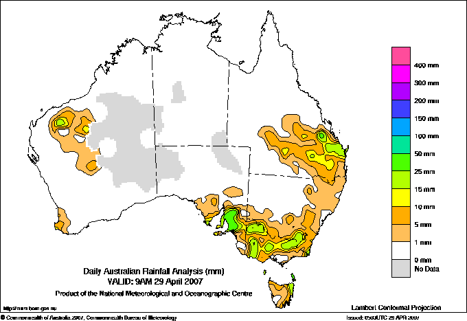
Todays highest rainfall totals for the 24 hours to 9am. It
includes the top 5 totals nationally followed by all reported falls of 50mm or more. |
Highest
and lowest recordings of hours of sunshine for the 24 hours to midnight. |
Highest wind
run totals in kilometres for the 24 hours to 9am (average speed in brackets).
All reported runs >
=25km/h are shown. |
Highest wind
gusts in km/h for the 24 hours to midnight followed by the hour in which it occurred.
All stations with gusts >
89km/h are shown. |
97.0 ANDREWS (GERALKA) Lower North SA
84.4 LONGWOOD RIDGE (HEALY) Adelaide/Lofty SA
79.0 STRINGYBARK Adelaide/Lofty SA
77.8 EDEN VALLEY (MOUNT ADAM ALERT) Adelaide/Lofty SA
77.4 CUDLEE CREEK (BERRIE HILL O'DEAS ROAD) Adelaide/Lofty SA
SOUTH AUSTRALIA
Lower North
97.0 ANDREWS (GERALKA)
73.8 HALLETT (LORRAINE)
66.4 MINTARO
62.0 MINTARO (MARTINDALE)
58.4 SEVENHILL COLLEGE
57.6 MOUNT BRYAN
56.0 CLARE CARAVAN PARK
56.0 HILLTOWN
54.4 WATERVALE
54.4 BRINKWORTH (BUNGAREE)
50.2 CLARE (CALCANNIA)
Adelaide/Lofty
84.4 LONGWOOD RIDGE (HEALY)
79.0 STRINGYBARK
77.8 EDEN VALLEY (MOUNT ADAM ALERT)
77.4 CUDLEE CREEK (BERRIE HILL O'DEAS ROAD)
76.8 MYLOR (HOULGRAVES ALERT)
76.4 ASHTON MARBLE HILL ORCHARD
72.0 MOUNT BOLD RESERVOIR
71.0 CHERRY GARDENS
68.8 CHERRYVILLE ALERT
68.2 LONGWOOD
67.0 PICCADILLY (MOUNT LOFTY BOTANIC GARDEN)
66.2 VERDUN (SUTTON)
66.0 PICCADILLY (WOODHOUSE)
64.8 BIRDWOOD
64.0 MYLOR (BIGGS FLAT ALERT)
63.0 LOBETHAL MAIDMENT ROAD
58.0 CLARENDON
57.4 CRAFERS (MT LOFTY ALERT)
56.8 MOUNT LOFTY CHANNEL 9
56.4 WILLIAMSTOWN (GLEN GILLIAN)
55.8 LONG RIDGE (GREENHILL ALERT)
55.6 SUTTON CREEK ALERT
54.6 MOUNT PLEASANT
54.6 KERSBROOK (MABENJO)
52.8 BALHANNAH (KILLARA PARK)
52.2 MOUNT BARKER
52.0 KERSBROOK EFFLUENT PONDS
51.4 ALDGATE
51.0 GREENOCK KONCKE STREET
50.8 GUMERACHA
50.2 TORRENS GORGE (MONTACUTE)
50.2 HAHNDORF
50.0 MOUNT LOFTY (CLELAND CONSERVATION PARK)
Murray Valley
51.0 MONARTO ZOOLOGICAL PARK
VICTORIA
E Gippsland
53.6 GABO ISLAND LIGHTHOUSE
TASMANIA
E Coast
67.0 GRAY (BLUEBERRY COTTAGE)
62.6 CORNWALL
57.6 ST MARYS (CLIVE STREET)
Flinders Is/Bass St
61.5 SAWYERS BAY (WICKHAM)
52.2 WHITEMARK POST OFFICE
|
11.2 GOVE AIRPORT N Rivers NT
11.0 BROOME AIRPORT W Kimberley WA
11.0 ALICE SPRINGS AIRPORT N Plateau NT
11.0 WEIPA AERO N Peninsula QLD
11.0 CAIRNS AERO N Coast--Barron QLD
.....
0.0 WARWICK Darling Downs E QLD
0.0 SCOTTSDALE (WEST MINSTONE ROAD) N Coast TAS
0.0 BICHENO (COUNCIL DEPOT) E Coast TAS
0.0 LAKE LEAKE (ELIZABETH RIVER) E Coast TAS
0.0 HOBART AIRPORT Southeast TAS
0.0 GROVE (COMPARISON) Southeast TAS
0.0 LIAWENEE Central Plateau TAS
|
1265 (52.7) CAPE GRIM BAPS N Coast TAS
1072 (44.7) CAPE LEEUWIN Lower West WA
1036 (43.2) NEPTUNE ISLAND W Agricultural SA
1031 (43.0) MOUNT READ W Coast TAS
1016 (42.3) SWAN ISLAND E Coast TAS
924 (38.5) SNOWTOWN (RAYVILLE PARK) Lower North SA
902 (37.6) THREDBO AWS Snowy Mtns NSW
896 (37.3) EDDYSTONE POINT E Coast TAS
876 (36.5) MT HOTHAM Upper NE VIC
845 (35.2) SMITHTON AERODROME N Coast TAS
803 (33.5) HOGAN ISLAND Islands ISL
800 (33.3) COULTA (COLES POINT) W Agricultural SA
787 (32.8) MINLATON AERO Yorke Pen/Kanga Is SA
783 (32.6) MURRURUNDI GAP AWS Hunter Valley NSW
772 (32.2) NORTH SHIELDS (PORT LINCOLN AWS) W Agricultural SA
766 (31.9) CAPE NATURALISTE Lower West WA
754 (31.4) YUNTA AIRSTRIP Northeast SA
731 (30.5) CLEVE AERODROME W Agricultural SA
719 (30.0) WOOMERA AERODROME NW Pastoral SA
706 (29.4) SHEFFIELD SCHOOL FARM N Coast TAS
703 (29.3) WYNYARD AIRPORT N Coast TAS
702 (29.3) CEDUNA AMO W Agricultural SA
689 (28.7) WILSONS PROMONTORY LIGHTHOUSE W Gippsland VIC
686 (28.6) MOUNT CRAWFORD FIRE TOWER Adelaide/Lofty SA
682 (28.4) FALLS CREEK Upper NE VIC
673 (28.0) MOUNT BULLER Upper NE VIC
670 (27.9) ADELAIDE AIRPORT Adelaide/Lofty SA
669 (27.9) ROSEWORTHY AWS Adelaide/Lofty SA
635 (26.5) WUDINNA AERO W Agricultural SA
635 (26.5) KILMORE GAP N Central VIC
626 (26.1) DEVONPORT AIRPORT N Coast TAS
620 (25.8) FRIENDLY BEACHES E Coast TAS
615 (25.6) PORT AUGUSTA AERO W Agricultural SA
612 (25.5) MOUNT WELLINGTON Southeast TAS
610 (25.4) LOW HEAD N Coast TAS
608 (25.3) EDINBURGH RAAF Adelaide/Lofty SA
607 (25.3) CLARE HIGH SCHOOL Lower North SA
|
100/13 CAPE LEEUWIN Lower West WA
89/12 CAPE NATURALISTE Lower West WA
80/09 ROTTNEST ISLAND Lower West WA
80/16 BUNBURY Lower West WA
78/11 MANJIMUP Lower West WA
78/23 HOPETOUN NORTH Lower West WA
|
�