|
For notes on how to interpret
the data and quality control issues, see Daily Weather Summary Help.
**S** and **W** precede data flagged by the Bureau as suspicious or wrong
Data is as received at 00:20EST, 15/05/2012.
|
|
| |
Max
°
C |
+/- norm
°
C |
Min
°
C |
+/- norm
°
C |
Grass Min
°
C |
Rain to 9am mm |
Evaporation to 9am mm |
Sunshine hours |
Wind Run to 9am km (24-hour average km/h) |
Maximum Gust km/h / hour of occurrence |
| GERALDTON AIRPORT |
35.5 |
+7.9 |
15.2 |
-0.2 |
11.5 |
0.0 |
8.8 |
-- |
514 (21.4) |
41/09 |
| PERTH AIRPORT |
33.1 |
+7.6 |
15.0 |
+2.1 |
11.4 |
0.0 |
5.6 |
10.8 |
600 (25.0) |
54/05 |
| ALBANY AIRPORT |
27.6 |
+5.8 |
13.3 |
+1.7 |
11.1 |
0.2 |
4.4 |
9.4 |
492 (20.5) |
35/09 |
| BUNBURY |
28.3 |
+4.2 |
16.6 |
+5.1 |
-- |
0.0 |
-- |
-- |
357 (14.9) |
35/03 |
| MANDURAH |
30.8 |
-- |
17.5 |
-- |
-- |
0.0 |
-- |
-- |
383 (16.0) |
41/08 |
| DARWIN AIRPORT |
33.0 |
+0.3 |
23.5 |
-0.5 |
23.5 |
1.2 |
6.0 |
9.6 |
315 (13.1) |
35/15 |
| ALICE SPRINGS AIRPORT |
30.4 |
+2.2 |
11.9 |
-0.7 |
9.1 |
0.0 |
7.0 |
11.4 |
204 ( 8.5) |
34/13 |
| WHYALLA AERO |
23.6 |
0.0 |
14.4 |
+2.8 |
-- |
0.0 |
5.0 |
-- |
336 (14.0) |
48/16 |
| ADELAIDE (KENT TOWN) |
22.7 |
+0.1 |
13.7 |
+1.3 |
-- |
0.0 |
3.2 |
10.9 |
90 ( 3.8) |
18/17 |
| MOUNT GAMBIER AERO |
19.6 |
+0.2 |
10.3 |
+1.6 |
6.4 |
0.0 |
1.2 |
4.5 |
250 (10.4) |
32/16 |
| MOUNT ISA AERO |
35.3 |
+3.4 |
22.1 |
+3.6 |
18.7 |
0.0 |
8.0 |
11.2 |
315 (13.1) |
35/09 |
| CAIRNS AERO |
30.2 |
+1.0 |
22.8 |
+1.2 |
22.0 |
8.8 |
3.6 |
5.9 |
521 (21.7) |
50/10 |
| TOWNSVILLE AERO |
30.6 |
+1.0 |
22.2 |
+1.7 |
20.0 |
0.0 |
7.6 |
9.6 |
519 (21.6) |
46/10 |
| MACKAY M.O |
26.8 |
+0.1 |
22.0 |
+1.9 |
-- |
4.2 |
-- |
9.8 |
559 (23.3) |
43/02 |
| ROCKHAMPTON AERO |
29.4 |
+0.6 |
21.3 |
+3.5 |
19.9 |
0.0 |
9.4 |
-- |
400 (16.7) |
39/09 |
| BUNDABERG AERO |
29.7 |
+2.3 |
18.6 |
+1.1 |
-- |
0.0 |
7.2 |
-- |
476 (19.8) |
50/12 |
| NAMBOUR DPI |
26.0 |
-0.1 |
14.1 |
-1.3 |
-- |
0.4 |
3.0 |
-- |
70 ( 2.9) |
22/10 |
| COOLANGATTA |
27.5 |
+2.2 |
16.3 |
-0.7 |
-- |
0.0 |
-- |
-- |
249 (10.4) |
34/14 |
| BRISBANE AERO |
27.4 |
+1.4 |
15.8 |
-0.4 |
12.3 |
0.0 |
6.6 |
10.8 |
363 (15.1) |
32/14 |
| TOOWOOMBA AIRPORT |
25.3 |
+1.9 |
13.9 |
+0.6 |
-- |
0.0 |
-- |
-- |
533 (22.2) |
46/20 |
| GUNNEDAH RESOURCE CENTRE |
27.7 |
+2.6 |
14.0 |
+1.2 |
7.8 |
0.0 |
6.0 |
-- |
88 ( 3.7) |
-- |
| COFFS HARBOUR MO |
26.1 |
+2.1 |
16.2 |
+1.0 |
13.4 |
0.0 |
4.0 |
10.7 |
220 ( 9.2) |
35/13 |
| PORT MACQUARIE AIRPORT AWS |
26.4 |
+2.4 |
12.4 |
-1.3 |
-- |
0.0 |
-- |
-- |
-- |
-- |
| WILLIAMTOWN RAAF |
25.1 |
+1.5 |
11.4 |
-1.8 |
8.6 |
0.0 |
3.4 |
6.9 |
250 (10.4) |
30/12 |
| GOSFORD (NARARA RESEARCH STATION) AWS |
24.1 |
+0.5 |
12.5 |
+0.6 |
-- |
0.0 |
-- |
-- |
76 ( 3.2) |
24/14 |
| ORANGE AGRICULTURAL INSTITUTE |
22.3 |
+3.8 |
8.0 |
+0.8 |
4.5 |
0.0 |
3.0 |
6.0 |
-- |
-- |
| DUBBO AIRPORT AWS |
28.3 |
+3.8 |
13.5 |
+3.4 |
-- |
0.0 |
-- |
-- |
-- |
-- |
| SYDNEY AIRPORT AMO |
22.6 |
-0.3 |
17.4 |
+3.3 |
12.0 |
0.0 |
5.8 |
6.2 |
445 (18.5) |
43/11 |
| RICHMOND RAAF |
23.8 |
-0.1 |
11.5 |
+0.2 |
-- |
0.0 |
-- |
-- |
115 ( 4.8) |
28/13 |
| BELLAMBI AWS |
22.3 |
+0.2 |
16.5 |
+1.1 |
-- |
0.2 |
-- |
-- |
333 (13.9) |
35/12 |
| CANBERRA AIRPORT |
26.2 |
+6.2 |
8.1 |
+1.4 |
4.9 |
0.0 |
5.2 |
10.6 |
195 ( 8.1) |
46/16 |
| WAGGA WAGGA AMO |
29.1 |
+6.6 |
10.7 |
+1.6 |
9.6 |
0.0 |
5.2 |
11.0 |
220 ( 9.2) |
32/14 |
| ALBURY AIRPORT AWS |
27.8 |
+5.4 |
10.7 |
+2.7 |
-- |
0.0 |
-- |
-- |
77 ( 3.2) |
31/14 |
| MILDURA AIRPORT |
25.3 |
+1.8 |
11.8 |
+1.7 |
10.4 |
0.0 |
7.0 |
10.8 |
273 (11.4) |
34/14 |
| TATURA INST SUSTAINABLE AG |
22.9 |
+1.3 |
11.7 |
+3.5 |
-- |
0.0 |
5.0 |
-- |
312 (13.0) |
35/08 |
| BENDIGO AIRPORT |
21.3 |
+0.1 |
10.1 |
+2.7 |
-- |
0.0 |
-- |
-- |
333 (13.9) |
�
41/19 |
| MELBOURNE REGIONAL OFFICE |
20.3 |
0.0 |
14.7 |
+3.9 |
12.9 |
0.0 |
2.6 |
-- |
147 ( 6.1) |
21/11 |
| GEELONG AIRPORT |
18.3 |
-1.7 |
11.2 |
+1.9 |
-- |
0.2 |
-- |
-- |
233 ( 9.7) |
39/10 |
| BALLARAT AERODROME |
18.4 |
+0.8 |
10.3 |
+2.9 |
-- |
0.0 |
-- |
-- |
420 (17.5) |
46/16 |
| LAUNCESTON (TI TREE BEND) |
18.5 |
-0.4 |
4.2 |
-3.3 |
-- |
0.0 |
-- |
-- |
165 ( 6.9) |
17/12 |
| HOBART AIRPORT |
16.8 |
-1.3 |
5.5 |
-3.2 |
0.2 |
0.0 |
0.8 |
6.9 |
303 (12.6) |
30/11 |
| |
Max
°
C |
+/- norm
°
C |
Min
°
C |
+/- norm
°
C |
Grass Min
°
C |
Rain to 9am mm |
Evaporation to 9am mm |
Sunshine hours |
Wind Run to 9am km |
Maximum Gust km/h / hour of occurrence |
|
| Hottest |
| Highest maximum temperature> | Greatest variation above normal maximum |
Highest minimum temperature | Greatest variation above normal minimum |
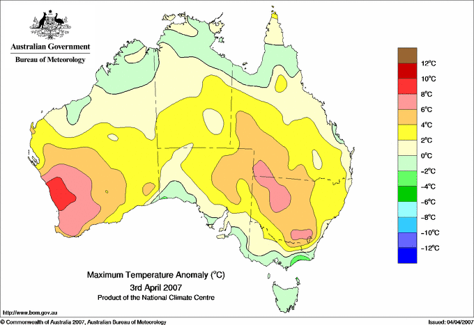
38.0 EMU CREEK STATION W Gascoyne WA
37.5 MARDIE W Pilbara WA
37.4 TOORAK RESEARCH STATION Gulf Country QLD
37.0 WYNDHAM AERO N Kimberley WA
|
+9.1 : 34.5 LANCELIN Lower West WA
+8.6 : 36.2 CARNAMAH Central West WA
+8.5 : 34.8 WONGAN HILLS Central West WA
+8.2 : 36.8 MULLEWA Central West WA
|
29.0 NORTHERN ENDEAVOUR Islands ISL
27.0 TROUGHTON ISLAND N Kimberley WA
26.9 SWEERS ISLAND Gulf Country QLD
26.8 CENTRE ISLAND N Rivers NT
26.8 VARANUS ISLAND Islands ISL
|
+11.0 : 20.0 HAY CSIRO AWS Riverina W NSW
+7.4 : 18.2 MENINDEE POST OFFICE Lower Darling NSW
+6.5 : 6.7 PERISHER VALLEY SKI CENTRE Snowy Mtns NSW
+6.1 : 18.5 WHITE CLIFFS POST OFFICE Far Northwest NSW
+6.0 : 14.5 EAST SALE AIRPORT W Gippsland VIC
|
| Coldest |
| Lowest maximum temperature | Greatest variation below normal maximum |
Lowest minimum temperature | Greatest variation below normal minimum |
7.0 MOUNT READ W Coast TAS
7.4 MOUNT WELLINGTON Southeast TAS
9.2 HARTZ MOUNTAIN (KEOGHS PIMPLE) Southeast TAS
10.0 MT BAW BAW W Gippsland VIC
10.9 LAKE ST CLAIR NATIONAL PARK Central Plateau TAS
|
-4.6 : 14.5 MT NOWA NOWA E Gippsland VIC
-3.7 : 14.5 MT MOORNAPA W Gippsland VIC
-3.1 : 17.8 ORBOST (COMPARISON) E Gippsland VIC
-3.0 : 32.5 PARDOO STATION E Pilbara WA
-2.9 : 12.9 MAYDENA POST OFFICE Derwent Valley TAS
|
-1.2 LIAWENEE Central Plateau TAS
-0.4 MOUNT WELLINGTON Southeast TAS
-0.3 TUNNACK FIRE STATION Southeast TAS
0.7 CRESSY RESEARCH STATION N Coast TAS
1.0 GROVE (RESEARCH STATION) Southeast TAS
|
-5.3 : -0.3 TUNNACK FIRE STATION Southeast TAS
-4.8 : 3.0 SCOTTSDALE (WEST MINSTONE ROAD) N Coast TAS
-4.6 : 0.7 CRESSY RESEARCH STATION N Coast TAS
-4.6 : 2.5 CAMPANIA (KINCORA) Southeast TAS
-4.2 : 2.0 GROVE (COMPARISON) Southeast TAS
|
|
Sunniest &
dullest |
Windiest |
Highest gusts |
Todays highest rainfall totals for the 24 hours to 9am. It
includes the top 5 totals nationally followed by all reported falls of 50mm or more. |
Highest
and lowest recordings of hours of sunshine for the 24 hours to midnight. |
Highest wind
run totals in kilometres for the 24 hours to 9am (average speed in brackets).
All reported runs >
=25km/h are shown. |
Highest wind
gusts in km/h for the 24 hours to midnight followed by the hour in which it occurred.
All stations with gusts >
89km/h are shown. |
102.0 DAINTREE TEA N Coast--Barron QLD
100.0 DAINTREE VILLAGE N Coast--Barron QLD
87.6 WHYANBEEL VALLEY N Coast--Barron QLD
75.0 SHIPTONS FLAT N Coast--Barron QLD
73.0 TOPAZ N Coast--Barron QLD
QUEENSLAND
N Coast--Barron
102.0 DAINTREE TEA
100.0 DAINTREE VILLAGE
87.6 WHYANBEEL VALLEY
75.0 SHIPTONS FLAT
73.0 TOPAZ
60.6 LOW ISLES LIGHTHOUSE
57.0 TOPAZ ALERT
56.4 HAZELMERE
56.0 MOSSMAN SOUTH ALCHERA DRIVE
53.4 REEF PARK
52.0 MOSSMAN CENTRAL MILL
|
11.4 ALICE SPRINGS AIRPORT N Plateau NT
11.3 BROOME AIRPORT W Kimberley WA
11.2 RABBIT FLAT N Plateau NT
11.2 MOUNT ISA AERO Gulf Country QLD
11.0 LOXTON RESEARCH CENTRE Murray Valley SA
11.0 WAGGA WAGGA AMO SW Slopes S NSW
.....
4.1 MELBOURNE AIRPORT E Central VIC
3.5 NORFOLK ISLAND AERO Islands ISL
3.4 BUNDOORA (LATROBE UNIVERSITY) E Central VIC
2.9 STRATHGORDON VILLAGE W Coast TAS
2.2 EAST SALE AIRPORT W Gippsland VIC
|
1112 (46.3) MAATSUYKER ISLAND LIGHTHOUSE Southeast TAS
1053 (43.9) LOW ISLES LIGHTHOUSE N Coast--Barron QLD
1023 (42.6) WILLIS ISLAND Islands ISL
928 (38.7) RUNDLE ISLAND Wide Bay/Burnett QLD
868 (36.2) DOUBLE ISLAND POINT LIGHTHOUSE Brisbane/SE Coast QLD
798 (33.3) CAPE LEEUWIN Lower West WA
757 (31.5) LADY ELLIOT ISLAND Wide Bay/Burnett QLD
735 (30.6) CAPE GRIM BAPS N Coast TAS
733 (30.5) CAPE MORETON LIGHTHOUSE Brisbane/SE Coast QLD
721 (30.0) HARTZ MOUNTAIN (KEOGHS PIMPLE) Southeast TAS
699 (29.1) MOUNT WELLINGTON Southeast TAS
696 (29.0) NORTH ISLAND Central West WA
682 (28.4) FLINDERS ISLAND AIRPORT Flinders Is/Bass St TAS
671 (28.0) THREDBO AWS Snowy Mtns NSW
643 (26.8) CAPE BRUNY (CAPE BRUNY) Southeast TAS
628 (26.2) CAPE WILLOUGHBY Yorke Pen/Kanga Is SA
614 (25.6) HOGAN ISLAND Islands ISL
611 (25.5) ROTTNEST ISLAND Lower West WA
609 (25.4) WILSONS PROMONTORY LIGHTHOUSE W Gippsland VIC
606 (25.3) LOW HEAD N Coast TAS
605 (25.2) LUCINDA POINT N Coast--Herbert QLD
600 (25.0) PERTH AIRPORT Lower West WA
|
72/11 CENTRE ISLAND N Rivers NT
72/04 LOW ISLES LIGHTHOUSE N Coast--Barron QLD
67/07 HARTZ MOUNTAIN (KEOGHS PIMPLE) Southeast TAS
67/04 WILLIS ISLAND Islands ISL
65/08 MAATSUYKER ISLAND LIGHTHOUSE Southeast TAS
|
�