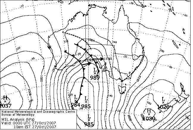
|
For notes on how to interpret
the data and quality control issues, see Daily Weather Summary Help.
**S** and **W** precede data flagged by the Bureau as suspicious or wrong
Data is as received at 01:27EST, 15/05/2012.
|
|
| |
Max
°
C |
+/- norm
°
C |
Min
°
C |
+/- norm
°
C |
Grass Min
°
C |
Rain to 9am mm |
Evaporation to 9am mm |
Sunshine hours |
Wind Run to 9am km (24-hour average km/h) |
Maximum Gust km/h / hour of occurrence |
| GERALDTON AIRPORT |
23.1 |
-1.3 |
17.0 |
+6.1 |
15.3 |
0.0 |
7.8 |
-- |
468 (19.5) |
52/19 |
| PERTH AIRPORT |
21.0 |
-1.5 |
16.3 |
+6.1 |
14.5 |
0.0 |
7.0 |
4.6 |
543 (22.6) |
65/20 |
| ALBANY AIRPORT |
17.0 |
-1.7 |
12.9 |
+3.8 |
11.5 |
0.0 |
8.0 |
4.7 |
337 (14.0) |
55/20 |
| BUNBURY |
18.1 |
-2.6 |
14.0 |
+4.8 |
-- |
5.4 |
-- |
-- |
400 (16.7) |
63/18 |
| MANDURAH |
18.8 |
-- |
16.0 |
-- |
-- |
0.0 |
-- |
-- |
475 (19.8) |
78/23 |
| DARWIN AIRPORT |
34.8 |
+1.6 |
26.6 |
+1.6 |
26.2 |
0.0 |
10.4 |
11.4 |
391 (16.3) |
35/14 |
| ALICE SPRINGS AIRPORT |
35.9 |
+4.9 |
13.6 |
-1.2 |
12.2 |
0.0 |
9.2 |
10.3 |
264 (11.0) |
61/18 |
| WHYALLA AERO |
28.0 |
+4.1 |
10.9 |
+0.4 |
-- |
0.0 |
6.4 |
-- |
302 (12.6) |
37/15 |
| ADELAIDE (KENT TOWN) |
26.4 |
+4.6 |
8.8 |
-2.6 |
-- |
0.0 |
3.8 |
12.8 |
162 ( 6.8) |
24/10 |
| MOUNT GAMBIER AERO |
21.6 |
+3.7 |
10.0 |
+2.9 |
9.8 |
0.0 |
3.4 |
11.5 |
428 (17.8) |
37/07 |
| MOUNT ISA AERO |
33.6 |
-1.0 |
15.0 |
-3.6 |
12.9 |
0.0 |
11.0 |
5.6 |
306 (12.8) |
34/10 |
| CAIRNS AERO |
31.3 |
+1.8 |
20.0 |
-0.6 |
16.2 |
0.0 |
8.4 |
11.0 |
154 ( 6.4) |
34/13 |
| TOWNSVILLE AERO |
31.8 |
+2.4 |
21.8 |
+1.1 |
19.9 |
0.0 |
10.0 |
11.9 |
321 (13.4) |
37/14 |
| MACKAY M.O |
30.9 |
+3.3 |
20.8 |
+1.1 |
-- |
0.0 |
-- |
11.0 |
269 (11.2) |
41/14 |
| ROCKHAMPTON AERO |
33.8 |
+4.1 |
20.2 |
+3.2 |
18.9 |
0.0 |
7.0 |
-- |
328 (13.7) |
50/21 |
| BUNDABERG AERO |
28.5 |
+1.6 |
21.6 |
+5.0 |
-- |
0.5 |
5.7 |
-- |
362 (15.1) |
41/13 |
| NAMBOUR DPI |
29.4 |
+2.7 |
19.8 |
+6.0 |
-- |
0.8 |
4.2 |
-- |
114 ( 4.8) |
31/14 |
| COOLANGATTA |
25.1 |
+0.7 |
18.4 |
+2.2 |
-- |
7.2 |
-- |
-- |
384 (16.0) |
44/00 |
| BRISBANE AERO |
27.1 |
+1.6 |
19.0 |
+3.3 |
18.8 |
8.0 |
7.0 |
8.4 |
411 (17.1) |
41/14 |
| TOOWOOMBA AIRPORT |
25.4 |
+0.7 |
15.3 |
+2.5 |
-- |
24.0 |
-- |
-- |
401 (16.7) |
43/15 |
| GUNNEDAH RESOURCE CENTRE |
27.1 |
+2.0 |
13.9 |
+1.8 |
12.2 |
10.8 |
2.4 |
-- |
119 ( 5.0) |
-- |
| COFFS HARBOUR MO |
24.2 |
+0.6 |
17.1 |
+3.3 |
16.6 |
1.8 |
4.8 |
7.8 |
341 (14.2) |
-- |
| PORT MACQUARIE AIRPORT AWS |
24.7 |
+0.7 |
15.8 |
+3.9 |
-- |
24.0 |
-- |
-- |
-- |
-- |
| WILLIAMTOWN RAAF |
25.0 |
+1.4 |
15.7 |
+3.7 |
15.5 |
2.8 |
2.0 |
7.1 |
265 (11.0) |
32/17 |
| GOSFORD (NARARA RESEARCH STATION) AWS |
24.8 |
+1.1 |
14.1 |
+3.4 |
-- |
6.8 |
-- |
-- |
53 ( 2.2) |
21/12 |
| ORANGE AGRICULTURAL INSTITUTE |
18.2 |
+0.7 |
7.8 |
+1.2 |
4.8 |
0.6 |
0.6 |
6.4 |
-- |
-- |
| DUBBO AIRPORT AWS |
26.4 |
+1.6 |
12.6 |
+3.2 |
-- |
2.0 |
-- |
-- |
-- |
-- |
| SYDNEY AIRPORT AMO |
23.6 |
+1.1 |
16.4 |
+3.3 |
13.7 |
2.8 |
1.2 |
5.4 |
311 (13.0) |
28/12 |
| RICHMOND RAAF |
24.3 |
-0.7 |
15.0 |
+4.0 |
-- |
2.6 |
-- |
-- |
110 ( 4.6) |
46/13 |
| BELLAMBI AWS |
21.6 |
0.0 |
16.7 |
+2.8 |
-- |
8.0 |
-- |
-- |
94 ( 3.9) |
22/14 |
| CANBERRA AIRPORT |
23.4 |
+4.0 |
12.3 |
+6.2 |
10.8 |
8.0 |
1.8 |
7.6 |
150 ( 6.3) |
52/15 |
| WAGGA WAGGA AMO |
22.6 |
+1.2 |
14.9 |
+7.2 |
14.6 |
1.2 |
4.4 |
2.6 |
230 ( 9.6) |
28/15 |
| ALBURY AIRPORT AWS |
23.2 |
+1.6 |
15.2 |
+7.2 |
-- |
16.8 |
-- |
-- |
116 ( 4.8) |
35/14 |
| MILDURA AIRPORT |
26.6 |
+2.8 |
10.7 |
+0.9 |
9.5 |
0.0 |
8.0 |
11.0 |
325 (13.5) |
39/13 |
| TATURA INST SUSTAINABLE AG |
24.9 |
+4.0 |
11.8 |
+4.3 |
-- |
0.0 |
3.6 |
-- |
411 (17.1) |
24/05 |
| BENDIGO AIRPORT |
23.2 |
+2.9 |
10.3 |
+4.0 |
-- |
0.0 |
-- |
-- |
355 (14.8) | �
24/11 |
| MELBOURNE REGIONAL OFFICE |
23.0 |
+3.4 |
12.5 |
+3.0 |
11.8 |
1.4 |
0.2 |
-- |
174 ( 7.3) |
18/01 |
| GEELONG AIRPORT |
18.8 |
0.0 |
11.1 |
+3.5 |
-- |
4.2 |
-- |
-- |
269 (11.2) |
26/16 |
| BALLARAT AERODROME |
19.3 |
+2.7 |
8.5 |
+2.3 |
-- |
2.4 |
-- |
-- |
611 (25.5) |
46/00 |
| LAUNCESTON (TI TREE BEND) |
20.0 |
+2.0 |
9.3 |
+2.4 |
-- |
0.0 |
-- |
-- |
203 ( 8.5) |
30/17 |
| HOBART AIRPORT |
18.3 |
+1.0 |
12.5 |
+5.0 |
12.2 |
0.0 |
5.6 |
2.1 |
374 (15.6) |
37/13 |
| |
Max
°
C |
+/- norm
°
C |
Min
°
C |
+/- norm
°
C |
Grass Min
°
C |
Rain to 9am mm |
Evaporation to 9am mm |
Sunshine hours |
Wind Run to 9am km |
Maximum Gust km/h / hour of occurrence |
|
| Hottest |
| Highest maximum temperature> | Greatest variation above normal maximum |
Highest minimum temperature | Greatest variation above normal minimum |
42.2 FITZROY CROSSING AERO W Kimberley WA
41.1 MARBLE BAR E Pilbara WA
40.9 CURTIN AERO W Kimberley WA
40.8 ROEBOURNE E Pilbara WA
40.7 ROEBOURNE AERO E Pilbara WA
|
+14.5 : 37.5 EUCLA Eucla WA
+12.9 : 35.8 EYRE Eucla WA
+11.5 : 35.9 NULLARBOR W Agricultural SA
+11.2 : 38.3 FORREST Eucla WA
+10.4 : 17.9 MOUNT READ W Coast TAS
+10.4 : 34.2 CEDUNA AMO W Agricultural SA
|
27.0 TROUGHTON ISLAND N Kimberley WA
26.9 WYNDHAM AERO N Kimberley WA
26.6 DARWIN AIRPORT N Rivers NT
26.5 NGUKURR N Rivers NT
26.1 DUM IN MIRRIE AWS N Rivers NT
26.1 CENTRE ISLAND N Rivers NT
|
+9.3 : 13.0 COOMA VISITORS CENTRE Goulburn/Monaro NSW
+8.8 : 15.0 RUTHERGLEN RESEARCH Lower NE VIC
+8.8 : 15.1 WANGARATTA AERO Lower NE VIC
+8.2 : 15.8 SALMON GUMS RES.STN. Goldfields WA
+7.9 : 11.2 COOMA AIRPORT AWS Goulburn/Monaro NSW
|
| Coldest |
| Lowest maximum temperature | Greatest variation below normal maximum |
Lowest minimum temperature | Greatest variation below normal minimum |
9.0 MT HOTHAM Upper NE VIC
9.3 MOUNT WELLINGTON Southeast TAS
9.6 THREDBO AWS Snowy Mtns NSW
9.6 MOUNT BULLER Upper NE VIC
11.4 MT BAW BAW W Gippsland VIC
|
-4.3 : 20.0 BEVERLEY Cent Wheatbelt WA
-4.2 : 16.5 KARNET Lower West WA
-4.0 : 34.7 BRADSHAW N Rivers NT
-3.9 : 33.8 TINDAL RAAF N Rivers NT
-3.9 : 17.0 BICKLEY Lower West WA
|
0.9 LIAWENEE Central Plateau TAS
2.9 ROSEDALE (TURRETFIELD RESEARCH CENTRE) Adelaide/Lofty SA
3.2 LAKE ST CLAIR NATIONAL PARK Central Plateau TAS
3.3 KEITH (MUNKORA) Mallee/Upper SE SA
3.4 MOUNT WELLINGTON Southeast TAS
|
-5.4 : 2.9 ROSEDALE (TURRETFIELD RESEARCH CENTRE) Adelaide/Lofty SA
-4.5 : 7.9 ROXBY DOWNS (OLYMPIC DAM AERODROME) NW Pastoral SA
-4.4 : 5.5 CEDUNA AMO W Agricultural SA
-4.2 : 12.7 LONGREACH AERO Central West QLD
-4.2 : 14.8 MANDORA E Pilbara WA
|
|
Sunniest &
dullest |
Windiest |
Highest gusts |
Todays highest rainfall totals for the 24 hours to 9am. It
includes the top 5 totals nationally followed by all reported falls of 50mm or more. |
Highest
and lowest recordings of hours of sunshine for the 24 hours to midnight. |
Highest wind
run totals in kilometres for the 24 hours to 9am (average speed in brackets).
All reported runs >
=25km/h are shown. |
Highest wind
gusts in km/h for the 24 hours to midnight followed by the hour in which it occurred.
All stations with gusts >
89km/h are shown. |
172.0 WALLEN WALLEN Brisbane/SE Coast QLD
161.0 DUNWICH Brisbane/SE Coast QLD
76.8 LAMB ISLAND PINE AVE Brisbane/SE Coast QLD
74.8 KALBAR TM Brisbane/SE Coast QLD
74.6 GREENMOUNT POST OFFICE Darling Downs E QLD
WESTERN AUSTRALIA
E Kimberley
59.0 WARMUN
NORTHERN TERRITORY
N Rivers
66.4 BULLITA
63.4 WALKER CREEK
58.8 NEWRY
56.2 ROSEWOOD
54.4 AUVERGNE
QUEENSLAND
Brisbane/SE Coast
172.0 WALLEN WALLEN
161.0 DUNWICH
76.8 LAMB ISLAND PINE AVE
74.8 KALBAR TM
72.0 ENGLESBERG VILLAGE
68.0 RUSSELL ISLAND
66.0 MOORANG
63.0 CAROLE PARK ALERT
62.0 POINT LOOKOUT
62.0 BOONAH STARK AVE
61.0 BOONAH ALERT
60.0 KARRAGARRA ISLAND
58.0 FOREST HOME TM
56.6 RHONDA
55.0 REDLAND BAY GOLF CLUB
54.4 TOWNSON
54.0 MT ALFORD
52.2 REDLANDS HRS
51.0 TAROME
50.5 MOUNT COTTON UNI FARM
50.2 ROSEVALE
Darling Downs E
74.6 GREENMOUNT POST OFFICE
72.2 MIRRABOOKA
67.0 BAIRNSDALE
60.0 NOBBY JACKSON ST
52.0 FELTON
50.0 NAVILLOWEEN
50.0 TAMBA
NEW SOUTH WALES
Upper Darling
57.8 COLLARENEBRI (ALBERT ST)
NW Plains W
57.8 COLLARENEBRI (POKATAROO (BELARRA))
NW Slopes N
50.0 UPPER HORTON (DUNBEACON)
NW Slopes S
59.8 WOOLBROOK (DANGLEMAH ROAD)
N Tablelands W
50.6 GUYRA (GOWAN BRAE)
N Tablelands E
53.4 CANGAI (SMELTER CREEK)
North Coast
73.2 MURWILLUMBAH (TALESWOOD)
59.0 BOAT HARBOUR (ROUS RIVER)
57.4 TOMEWIN (BORDER GATE)
MidNorth Coast S
51.4 BRETTI-MACKAY (BARNARD RIVER)
50.2 WAUKIVORY (THE RANCH)
South Coast
53.2 MONTAGUE ISLAND LIGHTHOUSE
Goulburn/Monaro
58.0 GURRUNDAH (ASHWELL)
56.0 GUNNING RURAL SUPPLIES
50.0 GURRUNDAH (WANDONGA)
Riverina E
62.0 TUPPAL (WARRAGOON)
|
12.8 ADELAIDE AIRPORT Adelaide/Lofty SA
12.8 ADELAIDE (KENT TOWN) Adelaide/Lofty SA
12.6 COBAR MO Upper Darling NSW
12.5 GILES METEOROLOGICAL OFFICE Interior WA
12.4 CEDUNA AMO W Agricultural SA
.....
1.0 LARRIMAH N Rivers NT
0.1 MELBOURNE AIRPORT E Central VIC
0.0 EAST SALE AIRPORT W Gippsland VIC
0.0 SCOTTSDALE (WEST MINSTONE ROAD) N Coast TAS
0.0 LAKE LEAKE (ELIZABETH RIVER) E Coast TAS
|
858 (35.8) CAPE GRIM BAPS N Coast TAS
634 (26.4) CAPE LEEUWIN Lower West WA
620 (25.8) ROTTNEST ISLAND Lower West WA
614 (25.6) WILLIS ISLAND Islands ISL
611 (25.5) BALLARAT AERODROME Western Plains VIC
607 (25.3) MAATSUYKER ISLAND LIGHTHOUSE Southeast TAS
|
96/21 CAPE LEEUWIN Lower West WA
89/19 CAPE NATURALISTE Lower West WA
87/21 ROTTNEST ISLAND Lower West WA
78/19 GARDEN ISLAND HSF Lower West WA
78/23 MANDURAH Lower West WA
78/23 MUNGLINUP WEST Goldfields WA
78/18 NEWCASTLE NOBBYS SIGNAL STATION AWS Hunter Valley NSW
|
�