|
For notes on how to interpret
the data and quality control issues, see Daily Weather Summary Help.
**S** and **W** precede data flagged by the Bureau as suspicious or wrong
Data is as received at 01:20EST, 15/05/2012.
|
|
| |
Max
°
C |
+/- norm
°
C |
Min
°
C |
+/- norm
°
C |
Grass Min
°
C |
Rain to 9am mm |
Evaporation to 9am mm |
Sunshine hours |
Wind Run to 9am km (24-hour average km/h) |
Maximum Gust km/h / hour of occurrence |
| GERALDTON AIRPORT |
21.5 |
-2.9 |
17.0 |
+6.1 |
15.3 |
0.0 |
6.0 |
-- |
434 (18.1) |
37/13 |
| PERTH AIRPORT |
26.2 |
+3.7 |
10.9 |
+0.7 |
8.5 |
0.0 |
4.6 |
11.4 |
363 (15.1) |
34/02 |
| ALBANY AIRPORT |
16.2 |
-2.5 |
12.3 |
+3.2 |
11.7 |
0.2 |
3.4 |
2.4 |
460 (19.2) |
45/12 |
| BUNBURY |
21.8 |
+1.1 |
11.9 |
+2.7 |
-- |
0.0 |
-- |
-- |
378 (15.8) |
50/23 |
| MANDURAH |
25.5 |
-- |
12.4 |
-- |
-- |
0.0 |
-- |
-- |
358 (14.9) |
41/21 |
| DARWIN AIRPORT |
33.3 |
+0.1 |
25.3 |
+0.3 |
25.0 |
0.0 |
6.8 |
10.0 |
357 (14.9) |
30/13 |
| ALICE SPRINGS AIRPORT |
37.5 |
+6.5 |
24.0 |
+9.2 |
21.2 |
0.0 |
11.8 |
8.3 |
291 (12.1) |
55/14 |
| WHYALLA AERO |
18.2 |
-5.7 |
12.2 |
+1.7 |
-- |
0.0 |
9.8 |
-- |
609 (25.4) |
44/16 |
| ADELAIDE (KENT TOWN) |
17.7 |
-4.1 |
8.4 |
-3.0 |
4.8 |
0.0 |
-- |
-- |
265 (11.0) |
37/14 |
| MOUNT GAMBIER AERO |
14.3 |
-3.6 |
6.8 |
-0.3 |
3.8 |
5.2 |
2.4 |
9.7 |
433 (18.0) |
35/08 |
| MOUNT ISA AERO |
38.2 |
+3.6 |
16.1 |
-2.5 |
14.3 |
0.0 |
11.2 |
8.3 |
245 (10.2) |
54/14 |
| CAIRNS AERO |
30.7 |
+1.2 |
21.9 |
+1.3 |
20.4 |
0.0 |
8.2 |
11.6 |
359 (15.0) |
35/13 |
| TOWNSVILLE AERO |
29.2 |
-0.2 |
21.8 |
+1.1 |
19.6 |
0.0 |
7.0 |
11.4 |
365 (15.2) |
34/12 |
| MACKAY M.O |
28.8 |
+1.2 |
19.3 |
-0.4 |
-- |
0.0 |
-- |
10.5 |
223 ( 9.3) |
30/14 |
| ROCKHAMPTON AERO |
33.0 |
+3.3 |
18.0 |
+1.0 |
16.3 |
0.0 |
6.8 |
-- |
256 (10.7) |
34/16 |
| BUNDABERG AERO |
28.1 |
+1.2 |
20.0 |
+3.4 |
-- |
0.0 |
5.4 |
-- |
363 (15.1) |
41/11 |
| NAMBOUR DPI |
30.2 |
+3.5 |
18.1 |
+4.3 |
-- |
0.0 |
-- |
-- |
89 ( 3.7) |
31/13 |
| COOLANGATTA |
26.6 |
+2.2 |
17.7 |
+1.5 |
-- |
0.0 |
-- |
-- |
329 (13.7) |
52/15 |
| BRISBANE AERO |
26.3 |
+0.8 |
18.5 |
+2.8 |
15.5 |
0.0 |
6.6 |
9.8 |
430 (17.9) |
61/16 |
| TOOWOOMBA AIRPORT |
30.6 |
+5.9 |
14.2 |
+1.4 |
-- |
0.0 |
-- |
-- |
429 (17.9) |
52/13 |
| GUNNEDAH RESOURCE CENTRE |
32.8 |
+7.7 |
12.5 |
+0.4 |
3.3 |
0.0 |
7.2 |
-- |
127 ( 5.3) |
-- |
| COFFS HARBOUR MO |
29.2 |
+5.6 |
13.7 |
-0.1 |
9.5 |
0.0 |
5.8 |
10.6 |
478 (19.9) |
48/13 |
| PORT MACQUARIE AIRPORT AWS |
28.2 |
+4.2 |
10.9 |
-1.0 |
-- |
0.0 |
-- |
-- |
-- |
-- |
| WILLIAMTOWN RAAF |
33.9 |
+10.3 |
6.7 |
-5.3 |
4.0 |
0.0 |
7.2 |
8.0 |
267 (11.1) |
58/11 |
| GOSFORD (NARARA RESEARCH STATION) AWS |
32.6 |
+8.9 |
6.5 |
-4.2 |
-- |
0.0 |
-- |
-- |
78 ( 3.3) |
48/17 |
| ORANGE AGRICULTURAL INSTITUTE |
22.3 |
+4.8 |
8.6 |
+2.0 |
0.8 |
0.0 |
6.4 |
6.6 |
-- |
-- |
| DUBBO AIRPORT AWS |
31.2 |
+6.4 |
3.7 |
-5.7 |
-- |
0.0 |
-- |
-- |
-- |
-- |
| SYDNEY AIRPORT AMO |
33.7 |
+11.2 |
12.6 |
-0.5 |
7.0 |
0.0 |
7.6 |
6.2 |
392 (16.3) |
89/14 |
| RICHMOND RAAF |
33.1 |
+8.1 |
8.2 |
-2.8 |
-- |
0.0 |
-- |
-- |
136 ( 5.7) |
76/12 |
| BELLAMBI AWS |
23.2 |
+1.6 |
14.7 |
+0.8 |
-- |
0.0 |
-- |
-- |
428 (17.8) |
78/12 |
| CANBERRA AIRPORT |
23.1 |
+3.7 |
10.9 |
+4.8 |
5.7 |
0.0 |
10.4 |
9.9 |
506 (21.1) |
52/14 |
| WAGGA WAGGA AMO |
22.0 |
+0.6 |
7.5 |
-0.2 |
5.4 |
0.0 |
6.6 |
10.9 |
219 ( 9.1) |
43/12 |
| ALBURY AIRPORT AWS |
20.0 |
-1.6 |
12.2 |
+4.2 |
-- |
0.0 |
-- |
-- |
223 ( 9.3) |
37/13 |
| MILDURA AIRPORT |
20.6 |
-3.2 |
9.3 |
-0.5 |
7.8 |
0.0 |
10.4 |
11.5 |
401 (16.7) |
41/01 |
| TATURA INST SUSTAINABLE AG |
18.6 |
-2.3 |
7.9 |
+0.4 |
-- |
0.0 |
-- |
-- |
373 (15.5) |
48/22 |
| BENDIGO AIRPORT |
17.9 |
-2.4 |
6.9 |
+0.6 |
-- |
0.0 |
-- |
-- |
468 (19.5) |
�
43/01 |
| MELBOURNE REGIONAL OFFICE |
16.0 |
-3.6 |
9.6 |
+0.1 |
7.2 |
4.0 |
3.8 |
-- |
205 ( 8.5) |
18/12 |
| GEELONG AIRPORT |
13.9 |
-4.9 |
6.6 |
-1.0 |
-- |
2.2 |
-- |
-- |
509 (21.2) |
43/00 |
| BALLARAT AERODROME |
12.9 |
-3.7 |
5.7 |
-0.5 |
-- |
1.6 |
-- |
-- |
556 (23.2) |
50/00 |
| LAUNCESTON (TI TREE BEND) |
14.0 |
-4.0 |
4.7 |
-2.2 |
-- |
0.0 |
-- |
-- |
246 (10.3) |
28/09 |
| HOBART AIRPORT |
12.5 |
-4.8 |
7.2 |
-0.3 |
-- |
0.0 |
3.6 |
6.7 |
373 (15.5) |
35/08 |
| |
Max
°
C |
+/- norm
°
C |
Min
°
C |
+/- norm
°
C |
Grass Min
°
C |
Rain to 9am mm |
Evaporation to 9am mm |
Sunshine hours |
Wind Run to 9am km |
Maximum Gust km/h / hour of occurrence |
|
| Hottest |
| Highest maximum temperature> | Greatest variation above normal maximum |
Highest minimum temperature | Greatest variation above normal minimum |
43.0 BOULIA AIRPORT Channel Country QLD
41.5 ELLIOTT N Plateau NT
40.9 BEDOURIE POLICE STATION Channel Country QLD
40.9 BALGO HILLS Interior WA
40.8 TOORAK RESEARCH STATION Gulf Country QLD
|
+11.2 : 33.7 SYDNEY AIRPORT AMO Sydney--east NSW
+10.3 : 32.4 SYDNEY (OBSERVATORY HILL) Sydney--east NSW
+10.3 : 33.9 WILLIAMTOWN RAAF Hunter Valley NSW
+9.8 : 31.9 NEWCASTLE NOBBYS SIGNAL STATION AWS Hunter Valley NSW
+9.7 : 32.2 NORAH HEAD AWS Hunter Valley NSW
|
27.9 VICTORIA RIVER DOWNS N Rivers NT
27.7 KIDMAN SPRINGS N Rivers NT
27.0 LARRIMAH N Rivers NT
27.0 DELAMERE WEAPONS RANGE N Rivers NT
27.0 TROUGHTON ISLAND N Kimberley WA
|
+9.2 : 24.0 ALICE SPRINGS AIRPORT N Plateau NT
+9.1 : 22.5 MARREE COMPARISON NE Pastoral SA
+6.9 : 22.0 OODNADATTA AIRPORT NE Pastoral SA
+6.7 : 21.7 KULGERA N Plateau NT
+6.3 : 12.6 TUGGERANONG (ISABELLA PLAINS) AWS Goulburn/Monaro NSW
|
| Coldest |
| Lowest maximum temperature | Greatest variation below normal maximum |
Lowest minimum temperature | Greatest variation below normal minimum |
0.6 MOUNT WELLINGTON Southeast TAS
1.7 MOUNT READ W Coast TAS
2.0 MT BAW BAW W Gippsland VIC
3.9 MT HOTHAM Upper NE VIC
4.5 LIAWENEE Central Plateau TAS
|
-8.0 : 10.1 COMBIENBAR AWS E Gippsland VIC
-6.7 : 11.2 BOMBALA AWS Goulburn/Monaro NSW
-6.6 : 0.6 MOUNT WELLINGTON Southeast TAS
-6.6 : 6.0 LAKE ST CLAIR NATIONAL PARK Central Plateau TAS
-6.5 : 10.0 MELTON MOWBRAY (NORTH STOCKMAN) Southeast TAS
-6.5 : 7.0 TARRALEAH VILLAGE Derwent Valley TAS
|
-3.6 MOUNT WELLINGTON Southeast TAS
-1.7 MOUNT BULLER Upper NE VIC
-1.5 MOUNT READ W Coast TAS
-1.3 MT BAW BAW W Gippsland VIC
-0.9 HARTZ MOUNTAIN (KEOGHS PIMPLE) Southeast TAS
-0.9 LIAWENEE Central Plateau TAS
|
-6.9 : 0.3 COONABARABRAN (NAMOI STREET) CW Slopes N NSW
-6.8 : 1.8 WUDINNA AERO W Agricultural SA
-6.8 : 3.0 CESSNOCK AIRPORT AWS Hunter Valley NSW
-6.2 : 3.8 MINNIPA DPI W Agricultural SA
-6.2 : 1.3 MUDGEE AIRPORT AWS C Tablelands N NSW
|
|
Sunniest &
dullest |
Windiest |
Highest gusts |
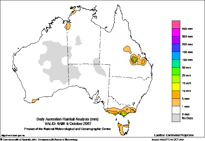
Todays highest rainfall totals for the 24 hours to 9am. It
includes the top 5 totals nationally followed by all reported falls of 50mm or more. |
Highest
and lowest recordings of hours of sunshine for the 24 hours to midnight. |
Highest wind
run totals in kilometres for the 24 hours to 9am (average speed in brackets).
All reported runs >
=25km/h are shown. |
Highest wind
gusts in km/h for the 24 hours to midnight followed by the hour in which it occurred.
All stations with gusts >
89km/h are shown. |
39.2 DEAL ISLAND Flinders Is/Bass St TAS
35.6 GOOVIGEN POST OFFICE Wide Bay/Burnett QLD
35.0 LYNWOOD Wide Bay/Burnett QLD
34.4 WINGAROO Flinders Is/Bass St TAS
33.2 KING ISLAND AIRPORT King Island TAS
|
11.6 CAIRNS AERO N Coast--Barron QLD
11.5 GILES METEOROLOGICAL OFFICE Interior WA
11.5 MILDURA AIRPORT Mallee N VIC
11.4 PERTH AIRPORT Lower West WA
11.4 TOWNSVILLE AERO N Coast--Herbert QLD
.....
5.1 STRATHGORDON VILLAGE W Coast TAS
4.5 GROVE (COMPARISON) Southeast TAS
2.4 ALBANY AIRPORT Lower West WA
1.9 LIAWENEE Central Plateau TAS
0.0 WARWICK Darling Downs E QLD
|
1166 (48.6) THREDBO AWS Snowy Mtns NSW
962 (40.1) MT HOTHAM Upper NE VIC
960 (40.0) MAATSUYKER ISLAND LIGHTHOUSE Southeast TAS
873 (36.4) HOGAN ISLAND Islands ISL
868 (36.2) FALLS CREEK Upper NE VIC
827 (34.5) WILSONS PROMONTORY LIGHTHOUSE W Gippsland VIC
781 (32.5) MOUNT BULLER Upper NE VIC
781 (32.5) COLAC (MT GELLIBRAND) W Coast VIC
760 (31.7) NEPTUNE ISLAND W Agricultural SA
735 (30.6) CAPE WILLOUGHBY Yorke Pen/Kanga Is SA
716 (29.8) CAPE LEEUWIN Lower West WA
695 (29.0) CEDUNA AMO W Agricultural SA
681 (28.4) MOUNT WELLINGTON Southeast TAS
675 (28.1) CAPE NELSON LIGHTHOUSE W Coast VIC
663 (27.6) COOBER PEDY AIRPORT NW Pastoral SA
663 (27.6) CAPE GRIM BAPS N Coast TAS
656 (27.3) WOOMERA AERODROME NW Pastoral SA
653 (27.2) HINDMARSH ISLAND AWS Adelaide/Lofty SA
649 (27.0) CAPE OTWAY LIGHTHOUSE W Coast VIC
647 (27.0) CAPE BRUNY (CAPE BRUNY) Southeast TAS
638 (26.6) PORT AUGUSTA AERO W Agricultural SA
630 (26.3) CAPE JAFFA (CURLEY HILLS) Lower SE SA
630 (26.3) VARANUS ISLAND Islands ISL
625 (26.0) WILLIS ISLAND Islands ISL
609 (25.4) WHYALLA AERO W Agricultural SA
609 (25.4) EDDYSTONE POINT E Coast TAS
|
100/00 THREDBO AWS Snowy Mtns NSW
89/14 SYDNEY AIRPORT AMO Sydney--east NSW
89/03 MT HOTHAM Upper NE VIC
87/02 MOUNT BULLER Upper NE VIC
87/00 HOGAN ISLAND Islands ISL
|
�