Tuesday 26 JUN 2007
 

Home page

DWS ARCHIVE
2024 2023 2022 2021 2020 2019 2018 2017 2016 2015 2014 2013 2012 2011 2010 2009 2008 2007 2006 2005 2004 2003
Before 2003

About the DWS


2007

Dec

M Tu W Th F Sa Su
          01 02
03 04 05 06 07 08 09
10 11 12 13 14 15 16
17 18 19 20 21 22 23
24 25 26 27 28 29 30
31            

Nov

M Tu W Th F Sa Su
      01 02 03 04
05 06 07 08 09 10 11
12 13 14 15 16 17 18
19 20 21 22 23 24 25
26 27 28 29 30    

Oct

M Tu W Th F Sa Su
01 02 03 04 05 06 07
08 09 10 11 12 13 14
15 16 17 18 19 20 21
22 23 24 25 26 27 28
29 30 31        

Sept

M Tu W Th F Sa Su
          01 02
03 04 05 06 07 08 09
10 11 12 13 14 15 16
17 18 19 20 21 22 23
24 25 26 27 28 29 30

August

M Tu W Th F Sa Su
    01 02 03 04 05
06 07 08 09 10 11 12
13 14 15 16 17 18 19
20 21 22 23 24 25 26
27 28 29 30 31    

July

M Tu W Th F Sa Su
            01
02 03 04 05 06 07 08
09 10 11 12 13 14 15
16 17 18 19 20 21 22
23 24 25 26 27 28 29
30 31          

June

M Tu W Th F Sa Su
        01 02 03
04 05 06 07 08 09 10
11 12 13 14 15 16 17
18 19 20 21 22 23 24
25 26 27 28 29 30  

May

M Tu W Th F Sa Su
  01 02 03 04 05 06
07 08 09 10 11 12 13
14 15 16 17 18 19 20
21 22 23 24 25 26 27
28 29 30 31      

April

M Tu W Th F Sa Su
            01
02 03 04 05 06 07 08
09 10 11 12 13 14 15
16 17 18 19 20 21 22
23 24 25 26 27 28 29
30            

March

M Tu W Th F Sa Su
      01 02 03 04
05 06 07 08 09 10 11
12 13 14 15 16 17 18
19 20 21 22 23 24 25
26 27 28 29 30 31  

February

M Tu W Th F Sa Su
      01 02 03 04
05 06 07 08 09 10 11
12 13 14 15 16 17 18
19 20 21 22 23 24 25
26 27 28        

January

M Tu W Th F Sa Su
01 02 03 04 05 06 07
08 09 10 11 12 13 14
15 16 17 18 19 20 21
22 23 24 25 26 27 28
29 30 31        

Monthly summaries:
from BoM

Find a place:
Google Maps |
Aust Gazetteer|
Geonames

Weather terms:
WeatherZone | BoM |
American Met Soc | NOAA | uk.sci.weather | India Meteorological Department

National Daily Weather Summary

Records set | Charts | Cities | Hottest | Coldest | Rain, sun & wind | Downpours & gales
State extremes | Noteworthy weather | Capital Cities | Regional Cities | Alpine Stations
Charts and data courtesy Bureau of Meteorology. MTSAT-1R operated by JMA
Noteworthy weather today
significant newsworthy major

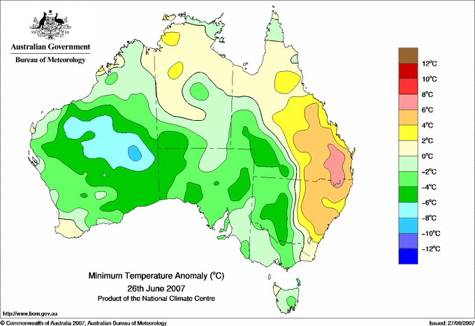
QLD: Cold wet weather contracts to the east. Yesterday's cold, wet spell that spanned much of tropical AUS contracted into inland and northern QLD today before clearing. Duneira and Drensmaine in the Central Highlands doubled their previous June rainfall records, while Musgrave on Cape York Peninsula equalled its lowest maximum temperature in a 17 year history at 22.4C.

Click image for animation.

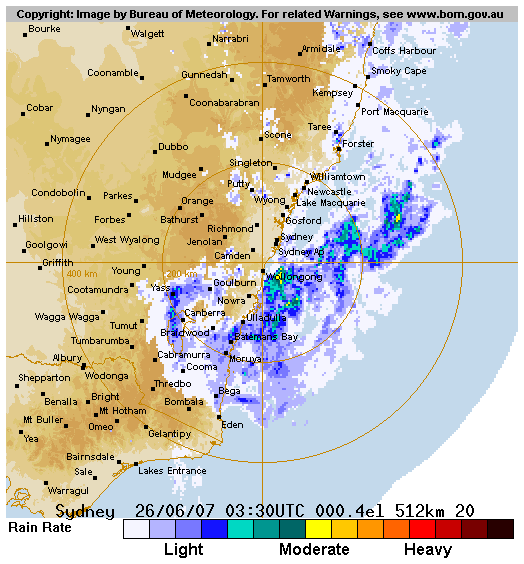
With the low centred near Nowra, rain begins to wrap around its southern flank, returning northwards through Canberra. It turns to heavy snow as it moves west across high ranges in the Michelago area south of Canberra.

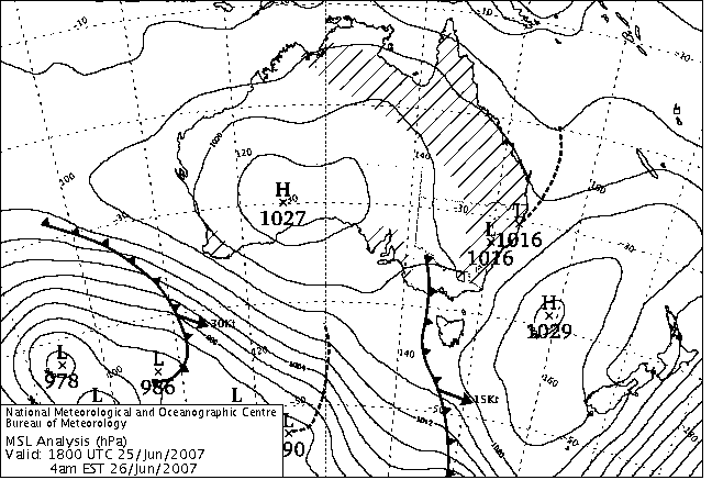
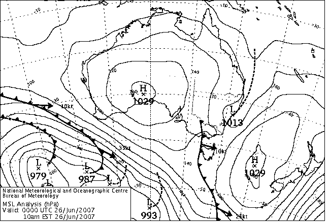
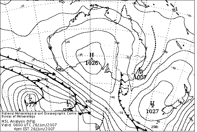
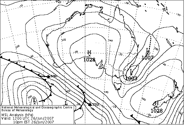
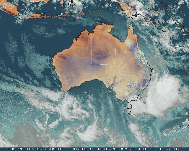
NSW: Fourth East Coast Low brings rain, freak snowfall. A trough that developed on the SE QLD coast yesterday morning spawned centres off the NSW North Coast and northwest of Sydney early this morning, and by mid afternoon a dominant centre had formed off the coast near Sydney and was moving south and deepening. By late evening, a second low had formed off the NSW North Coast and was moving SE.

The coastal developments were in response to a deep eastward-moving upper trough that lay along the NSW/SA border late this morning. This trough had sharpened yesterday, bringing a large blob of cold air northwards up its western side. As the trough moved east today, it developed into a cut-off low over western VIC which moved to central western NSW late this evening. This upper low and cold pool reached the coast overnight into Wednesday, dramatically intensifying the coastal trough and its pair of nested lows. Extreme rain and flooding resulted in eastern VIC and widespread snow in NSW (see stories 27 June).

Today, the trough brought moderate to heavy rain from the Gold Coast south to around Port Macquarie overnight, and by 9am many locations on the North and Mid North Coasts had recorded 50 to 100mm (see wettest). Moderate rain began falling the full length of the coast during the morning, and with good falls penetrating into the tablelands. Goulburn -- which has achieved notoriety for its drought-induced near-empty dams and level 5 water restrictions -- made headlines when heavy rain fell overnight and through the day, giving the city 52mm in 30 hours to 3pm with some locally heavier falls reported to the SES. Flooding from local creeks and the Wollondilly and Mulwaree Rivers, which meet at Goulburn, put the golf course and adjoining playing fields under water, closed about 12 local roads, threatened 20 properties in Eastgrove, and filled Sooley Dam, the smaller of the cities two water supplies. Local flooding also affected, but did not close, the Hume Highway at Marulan, 20km east. Canberra also recorded useful rain -- 49mm in the 48 hours to 9am Wednesday -- with the floodgates opened on Lake Burley Griffin's Scrivener Dam for the first time since 2002.

During the afternoon as the low approached Nowra, rain began to wrap around its southern flank and approached the area south of Canberra from the east. This pushed the moisture into the colder airmass moving in from the south and produced the day's most extraordinary event. A blizzard developed in the high country to the southeast of Michelago and snow spilt westward to close the Monaro Highway between Michelago and Bredbo soon after midday. A local indicated the highway was covered to a depth of 10cm near Michelago. Michelago settlement is about 690m elevation, and the highway rises to around 800m between there and Bredbo, but the mountains to the southeast rise to over 1300m and it was there that a 24-year-old woman on an isolated property on Calabash Fire Trail placed an emergency call at 6pm saying she was suffering an asthma attack, was snowed in and cold, and had been without power for 7 hours.

In an epic rescue, 29 emergency workers battled for 11 hours through snow described as "waist-deep" to get to her and take her to Canberra Hospital. The rescue effort involved 4 ambulance officers in two vehicles from Cooma and Canberra, 14 firefighters in 4 trucks to assist with clearing snow and fallen trees, and a bulldozer, a snow-clearing Caterpillar on its own truck from Perisher Valley and several 4WD vehicles and their respective drivers that joined the party as the going got tougher. The effort was co-ordinated from a distance by four senior officers from state, regional and sector levels, and a call-centre operator staying in contact with the woman. The party took about 4 hours to move 12km, chainsawing trees across the road and clearing deep snow. Snow continued to fall, and they had to fell some overhanging trees for clearance because of the depth of the snow on the road and the weight of the snow weighing down the branches. They were finally blocked 8km from the house at 10.10pm, so two ski-doos were brought from Perisher Valley in the back of another ambulance, along with two police officers, and the rescue was finally made at 3.55am. The woman was in Canberra Hospital at 5.37am in a stable condition.

The story, told in detail in the Sydney Morning Herald on 28 June , is a great example of the extraordinary weather that can occur in a small local area, but can pass unnoticed unless an event such as this brings it to light. The small settlement of Rossi, 25km SE of Queanbeyan and only 40km NE of the Calabash incident, recorded 51mm of rain between 9am and 2pm as the same rainband moved past; had this fallen as snow it would have resulted in a snowdepth of around half a metre.

As the low moved down the coast, the wrap-around rainfall also moved south, and by mid evening was running into the cold air south of Cooma. The Monaro Highway was closed from Cooma through Nimmitabel to Brown Mountain, and snow fell steadily around Cooma.


Records set or equalled today

These records are based on data received as at 0644 EST on 21/08/2008. Help in interpreting these statistics and information on quality control is here.

District Site Today Previous monthly record Previous all time record
if equalled or broken
Comments
Reading Reading Date Years Reading Date Years
Highest daily rainfall

QLD

Central Highlands

035283

DRENSMAINE

47.0

29.0

09/06/1999

15

1 y

QLD

Central West

036141

RODNEY DOWNS

30.6

22.0

21/06/1991

21

1 y

QLD

Central West

036166

IDALIA NATIONAL PARK

37.0

37.0

09/06/2006

18

1 y Equal to record.

QLD

Darling Downs E

041543

DUDDAWARRA

33.4

28.4

29/06/2005

11

1 n

QLD

Maranoa

043097

TEELBA

24.5

24.0

14/06/2005

13

1 y

QLD

Maranoa

043106

RICHLAND HILL

35.0

32.2

28/06/2005

16

1 y

NSW

MidNorth Coast N

059134

BELLINGEN (HYDE STREET)

96.6

74.2

30/06/2005

15

1 y

NSW

Goulburn/Monaro

070296

DALTON (MILVERTON)

53.8

47.2

27/06/1997

28

1 y

Lowest maximum temperature

QLD

S Peninsula

028007

MUSGRAVE

22.4

24.4

21/06/2007

16

22.4

09/07/1993

17

1 Y Previous record set earlier this month.

NSW

South Coast

069022

NAROOMA RVCP

10.5

10.6

12/06/1975

24

10.6

12/06/1975

27

1 Y

NSW

South Coast

069132

BRAIDWOOD RACECOURSE AWS

6.4

6.6

15/06/1995

14

1 Y

NSW

South Coast

069134

BATEMANS BAY (CATALINA COUNTRY CLUB)

10.7

11.7

20/06/2002

16

10.7

23/07/1993

17

1 Y

NSW

South Coast

069138

ULLADULLA AWS

11.1

11.1

15/06/1995

14

1 Y Equal to record.

NSW

South Coast

069139

BEGA AWS

9.7

10.6

11/06/2006

13

1 Y


The day in charts
Surface charts Satellite images Rain & temperatures
4am EST Rainfall -- 24 hours to 9am
Available about 6am EST Available about 4am EST Available about 2pm EST
Week to 9am | SE AUS detail
10am EST Minimum temperature +/- normal
Available about noon EST Available about 10am EST Available about 2pm EST next day
Actual temperatures
4pm EST Maximum temperature +/- normal
Available about 6pm EST Available about 4pm EST Available about 2pm EST next day
Actual temperatures
10pm EST Solar Radiation
Available about midnight EST Available about 10pm EST Available about 2am EST next day

Summary of observations

For notes on how to interpret the data and quality control issues, see Daily Weather Summary Help.
**S** and **W** precede data flagged by the Bureau as suspicious or wrong
Data is as received at 00:49EST, 15/05/2012.

Major centres
Max
° C
+/- norm
° C
Min
° C
+/- norm
° C
Grass Min
° C
Rain to 9am mm Evaporation to 9am mm Sunshine hours Wind Run to 9am km (24-hour average km/h) Maximum Gust km/h / hour of occurrence
GERALDTON AIRPORT 24.3 +3.4 8.0 -3.0 6.7 0.0 3.6 -- 392 (16.3) 46/10
PERTH AIRPORT 21.6 +2.7 6.0 -3.0 4.3 0.4 0.8 9.1 276 (11.5) 41/14
ALBANY AIRPORT 19.3 +2.7 10.3 +2.2 7.0 0.0 0.6 9.4 431 (18.0) 50/12
BUNBURY 19.6 +1.2 11.7 +3.6 -- 3.0 -- -- 319 (13.3) 44/14
MANDURAH 18.1 -- 12.6 -- -- 0.4 -- -- 445 (18.5) 48/10
DARWIN AIRPORT 29.0 -1.6 20.7 +0.8 20.3 0.0 6.2 6.5 555 (23.1) 54/15
ALICE SPRINGS AIRPORT 17.0 -2.8 3.8 -1.3 0.0 0.0 3.8 10.1 262 (10.9) 31/11
WHYALLA AERO 14.9 -2.4 3.6 -2.5 -- 2.8 3.8 -- 227 ( 9.5) 31/14
ADELAIDE (KENT TOWN) 14.2 -1.9 6.7 -1.4 4.8 4.0 2.4 7.6 168 ( 7.0) 28/13
MOUNT GAMBIER AERO 14.4 +0.6 3.3 -2.5 1.5 3.8 1.4 7.9 324 (13.5) 35/13
MOUNT ISA AERO 19.4 -5.5 10.2 +0.2 9.0 9.2 1.8 10.2 246 (10.3) 45/14
CAIRNS AERO 24.3 -1.7 19.2 +1.4 17.9 6.4 0.8 0.9 436 (18.2) 34/00
TOWNSVILLE AERO 20.9 -4.7 16.5 +1.9 16.1 10.2 2.4 0.2 454 (18.9) 52/23
MACKAY M.O 17.6 -4.3 15.5 +1.5 -- 34.0 -- 0.0 394 (16.4) 35/05
ROCKHAMPTON AERO 17.1 -6.4 15.4 +4.5 14.8 8.0 1.8 -- 157 ( 6.5) 26/20
BUNDABERG AERO 16.6 -6.0 15.4 +3.8 -- 9.2 1.8 -- 335 (14.0) 31/11
NAMBOUR DPI 16.5 -5.1 15.7 +6.4 -- 24.4 1.0 -- 13 ( 0.5) 30/19
COOLANGATTA 16.6 -4.5 15.8 +4.3 -- 67.8 -- -- 157 ( 6.5) 18/00
BRISBANE AERO 16.1 -5.2 15.5 +5.0 15.2 25.2 1.6 0.0 249 (10.4) 28/21
TOOWOOMBA AIRPORT 10.9 -6.1 10.5 +3.0 -- 13.4 -- -- 362 (15.1) 43/23
GUNNEDAH RESOURCE CENTRE 13.3 -3.5 8.3 +2.2 9.3 7.8 1.2 -- 129 ( 5.4) --
COFFS HARBOUR MO 16.4 -3.0 14.1 +5.0 14.4 122.2 -- 0.0 267 (11.1) 32/23
PORT MACQUARIE AIRPORT AWS 18.3 -1.2 12.9 +4.9 -- 51.0 -- -- -- --
WILLIAMTOWN RAAF 16.8 -0.8 12.4 +4.5 12.2 12.8 0.6 2.2 159 ( 6.6) 46/19
GOSFORD (NARARA RESEARCH STATION) AWS 15.3 -2.6 -- -- -- -- -- -- 34 ( 1.4) 21/06
ORANGE AGRICULTURAL INSTITUTE 7.0 -3.5 5.1 +2.5 5.5 16.0 0.0 0.5 -- --
DUBBO AIRPORT AWS 13.4 -3.0 9.9 +5.3 -- 11.0 -- -- -- --
SYDNEY AIRPORT AMO 16.5 -1.1 12.9 +4.4 11.8 8.2 1.0 0.0 306 (12.8) 48/07
RICHMOND RAAF 12.7 -5.3 10.0 +5.1 -- 13.0 -- -- 97 ( 4.0) 41/16
BELLAMBI AWS 14.5 -3.2 12.7 +1.7 -- 19.6 -- -- 213 ( 8.9) 46/13
CANBERRA AIRPORT 6.5 -5.7 3.9 +2.9 1.6 24.2 0.8 0.0 89 ( 3.7) 28/08
WAGGA WAGGA AMO 12.6 -1.2 2.7 -1.0 0.3 0.0 1.0 3.5 126 ( 5.3) 39/14
ALBURY AIRPORT AWS 11.9 -2.3 3.5 -0.4 -- 0.2 -- -- 48 ( 2.0) 13/12
MILDURA AIRPORT 14.3 -1.7 1.9 -3.3 -1.5 0.0 1.8 5.9 242 (10.1) --
TATURA INST SUSTAINABLE AG 13.5 -0.5 -1.5 -5.2 -- 0.0 1.6 -- 151 ( 6.3) 39/23
BENDIGO AIRPORT 12.7 -0.5 1.1 -2.5 -- 0.0 -- -- 160 ( 6.7) 35/13
MELBOURNE REGIONAL OFFICE 12.6 -1.4 7.7 +0.8 3.5 0.0 1.4 -- 101 ( 4.2) 21/22
GEELONG AIRPORT 12.1 -2.5 3.9 -2.4 -- 0.0 -- -- 208 ( 8.7) 37/15
BALLARAT AERODROME 10.1 -0.7 3.6 -0.4 -- 0.0 -- -- 488 (20.3) 41/14
LAUNCESTON (TI TREE BEND) 11.6 -1.5 0.8 -2.1 -- 0.2 -- -- 38 ( 1.6) 15/18
HOBART AIRPORT 12.0 -0.9 2.0 -2.6 0.0 0.0 0.2 4.3 276 (11.5) 24/21
Max
° C
+/- norm
° C
Min
° C
+/- norm
° C
Grass Min
° C
Rain to 9am mm Evaporation to 9am mm Sunshine hours Wind Run to 9am km Maximum Gust km/h / hour of occurrence
Hottest
Highest maximum temperature>Greatest variation above normal maximum Highest minimum temperatureGreatest variation above normal minimum

29.8 MIDDLE POINT AWS N Rivers NT
29.5 KURI BAY N Kimberley WA
29.0 DARWIN AIRPORT N Rivers NT
29.0 HORN ISLAND N Peninsula QLD
28.8 BATCHELOR AERO N Rivers NT
28.8 COCOS ISLAND AIRPORT Islands ISL

+4.4 : 21.8 DONNYBROOK Lower West WA
+3.9 : 26.7 KALBARRI Central West WA
+3.9 : 20.4 ALBANY Lower West WA
+3.8 : 11.0 HARTZ MOUNTAIN (KEOGHS PIMPLE) Southeast TAS
+3.4 : 24.3 GERALDTON AIRPORT Central West WA

25.7 COCONUT ISLAND N Peninsula QLD
25.0 WILLIS ISLAND Islands ISL
24.6 COCOS ISLAND AIRPORT Islands ISL
23.6 HORN ISLAND N Peninsula QLD
22.4 POINT FAWCETT Islands ISL

+9.0 : 9.0 WOOLBROOK (DANGLEMAH ROAD) NW Slopes S NSW
+7.8 : 14.8 AMBERLEY AMO Brisbane/SE Coast QLD
+7.6 : 7.6 GLEN INNES AIRPORT AWS N Tablelands W NSW
+7.6 : 10.0 TENTERFIELD (FEDERATION PARK) N Tablelands W NSW
+7.5 : 11.6 OAKEY AERO Darling Downs E QLD

Coldest
Lowest maximum temperatureGreatest variation below normal maximum Lowest minimum temperatureGreatest variation below normal minimum

-2.3 MT HOTHAM Upper NE VIC
-1.2 FALLS CREEK Upper NE VIC
-0.8 THREDBO AWS Snowy Mtns NSW
-0.5 MOUNT BULLER Upper NE VIC
0.8 CHARLOTTE PASS (KOSCIUSKO CHALET) Snowy Mtns NSW

-12.7 : 16.6 CROYDON TOWNSHIP Gulf Country QLD
-9.5 : 18.7 GEORGETOWN POST OFFICE Upper Carpentaria QLD
-9.2 : 10.1 INGLEWOOD FOREST Darling Downs E QLD
-9.1 : 17.0 RICHMOND POST OFFICE Upper Carpentaria QLD
-8.9 : 17.7 RICHMOND AIRPORT Upper Carpentaria QLD

-5.8 MT HOTHAM Upper NE VIC
-4.6 FALLS CREEK Upper NE VIC
-4.0 MT HOTHAM AIRPORT Upper NE VIC
-3.7 MOUNT BULLER Upper NE VIC
-3.5 TUMBARUMBA POST OFFICE SW Slopes S NSW

-9.1 : -2.2 EYRE Eucla WA
-8.1 : -3.4 YEELIRRIE Goldfields WA
-7.9 : -0.5 MURCHISON W Gascoyne WA
-7.4 : -1.1 WARBURTON AIRFIELD Interior WA
-7.0 : -0.5 NEWMAN AERO E Gascoyne WA

Wettest
Sunniest & dullest
Windiest
Highest gusts
Todays highest rainfall totals for the 24 hours to 9am. It includes the top 5 totals nationally followed by all reported falls of 50mm or more.
Highest and lowest recordings of hours of sunshine for the 24 hours to midnight.
Highest wind run totals in kilometres for the 24 hours to 9am (average speed in brackets). All reported runs > =25km/h are shown.
Highest wind gusts in km/h for the 24 hours to midnight followed by the hour in which it occurred. All stations with gusts > 89km/h are shown.
122.2 COFFS HARBOUR MO MidNorth Coast N NSW
105.2 WOOLGOOLGA (CLEAR PLACE) MidNorth Coast N NSW
96.6 BELLINGEN (HYDE STREET) MidNorth Coast N NSW
92.8 MACKSVILLE COUNTRY CLUB MidNorth Coast N NSW
90.8 COURAN COVE Brisbane/SE Coast QLD

QUEENSLAND
Central Highlands
57.0 WADDY BRAE
55.0 YANDABURRA
53.0 WHARTON CREEK STATION
Central West
50.8 BLACKALL AIRPORT
Brisbane/SE Coast
90.8 COURAN COVE
86.0 RUSSELL ISLAND
67.8 COOLANGATTA
67.2 WALLEN WALLEN
66.4 LAMB ISLAND PINE AVE
66.2 DUNWICH
60.6 KARRAGARRA ISLAND
59.4 ROCKY POINT SUGAR MILL
57.0 MT ALFORD
Warrego
51.0 NIVE DOWNS
50.0 LOCHINVAR

NEW SOUTH WALES
North Coast
78.0 MINNIE WATER PUMP SHED
76.8 TWEED HEADS GOLF CLUB
67.6 BYRON BAY (CAPE BYRON LIGHTHOUSE)
63.0 WOOLI BEACH
62.6 BYRON BAY (CAPE BYRON AWS)
58.8 YAMBA PILOT STATION
56.6 BYRON BAY (JACARANDA DRIVE)
54.2 KINGSCLIFF (MARINE PARADE)
MidNorth Coast N
122.2 COFFS HARBOUR MO
105.2 WOOLGOOLGA (CLEAR PLACE)
96.6 BELLINGEN (HYDE STREET)
92.8 MACKSVILLE COUNTRY CLUB
89.8 URUNGA (SUNSET PLACE)
85.0 BOWRAVILLE RECREATION CLUB
83.2 KEMPSEY (WIDE STREET)
82.0 EUROKA (ALDAVILLA)
79.6 UPPER ORARA (AURANIA)
74.8 KEMPSEY AIRPORT AWS
73.0 CRESCENT HEAD
72.4 EUNGAI CREEK (SOUTHBANK ROAD)
65.4 LOWER BUCCA
62.0 BOWRA SUGARLOAF
60.5 WITTITRIN
58.8 SOUTH WEST ROCKS (SMOKY CAPE LIGHTHOUSE)
57.2 BOWRAVILLE (COW COWNTY)
55.0 CRESCENT HEAD (DELICATE NOBBY (BIG HILL
54.0 TAYLORS ARM (LEMON GROVE)
50.0 PROMISED LAND (BELLINGEN (CRYSTAL CREEKS
MidNorth Coast S
76.0 UPPER ROLLANDS PLAINS (GREENACRES)
74.0 KUNDABUNG (RAVENSWOOD RD)
61.4 HARRINGTON (OXLEY ANCHORAGE CARAVAN PARK
58.4 TELEGRAPH POINT (FARRAWELLS ROAD)
55.0 MOORLAND (DENRO-AN)
53.0 LONG FLAT POST OFFICE
52.6 KENDALL POST OFFICE
51.0 PORT MACQUARIE AIRPORT AWS
50.6 OLD BAR (MOLONG RD)
Illawarra
57.0 FOXGROUND ROAD
Goulburn/Monaro
53.8 DALTON (MILVERTON)
50.1 BRAYTON (LONGREACH)

10.6 BROOME AIRPORT W Kimberley WA
10.5 GILES METEOROLOGICAL OFFICE Interior WA
10.2 MOUNT ISA AERO Gulf Country QLD
10.1 TENNANT CREEK AIRPORT N Plateau NT
10.1 ALICE SPRINGS AIRPORT N Plateau NT

.....

0.0 MACKAY M.O Central Coast E QLD
0.0 BRISBANE AERO Brisbane/SE Coast QLD
0.0 INVERELL RESEARCH CENTRE N Tablelands W NSW
0.0 COFFS HARBOUR MO MidNorth Coast N NSW
0.0 SYDNEY AIRPORT AMO Sydney--east NSW
0.0 CANBERRA AIRPORT Goulburn/Monaro NSW
0.0 EAST SALE AIRPORT W Gippsland VIC
0.0 SCOTTSDALE (WEST MINSTONE ROAD) N Coast TAS
0.0 COWRA RESEARCH CENTRE (EVANS ST) C Tablelands S NSW
0.0 KAIRI RESEARCH STATION N Coast--Barron QLD
0.0 WALKAMIN DPI N Coast--Barron QLD
0.0 BRIAN PASTURES Brisbane/SE Coast QLD
0.0 ALSTONVILLE TROPICAL FRUIT RESEARCH STAT North Coast NSW
0.0 SCONE SCS Hunter Valley NSW

901 (37.5) VARANUS ISLAND Islands ISL
875 (36.5) MOUNT READ W Coast TAS
793 (33.0) CAPE LEEUWIN Lower West WA
745 (31.0) MCCLUER ISLAND N Rivers NT
729 (30.4) LORD HOWE ISLAND AERO Islands ISL
717 (29.9) MOUNT BULLER Upper NE VIC
712 (29.7) BARROW ISLAND AIRPORT W Pilbara WA
710 (29.6) MT HOTHAM Upper NE VIC
706 (29.4) THREDBO AWS Snowy Mtns NSW
687 (28.6) CAPE FLATTERY N Coast--Barron QLD
669 (27.9) CENTRE ISLAND N Rivers NT
669 (27.9) LOW ISLES LIGHTHOUSE N Coast--Barron QLD
657 (27.4) CAPE NATURALISTE Lower West WA
654 (27.3) GOVE AIRPORT N Rivers NT
623 (26.0) WILLIS ISLAND Islands ISL
616 (25.7) FALLS CREEK Upper NE VIC
606 (25.3) NGAYAWILI N Rivers NT
98/22 MONTAGUE ISLAND LIGHTHOUSE South Coast NSW
93/23 GREEN CAPE AWS South Coast NSW
89/23 FALLS CREEK Upper NE VIC
85/22 LORD HOWE ISLAND AERO Islands ISL
81/22 GABO ISLAND LIGHTHOUSE E Gippsland VIC

Downpours High AWS wind reports
High rainfall for periods of 6 hours or less from AWS and synoptic reports. Storm force gusts (>89km/h) and 10-minute mean gales (>62km/h) reported by AWSs. Wind direction and mean windspeed are shown in brackets.
QUEENSLAND
Central Coast E
HAMILTON ISLAND AIRPORT
16.0mm in 3 hr to 06:00 5.3mm/h
Brisbane/SE Coast
COOLANGATTA
30.0mm in 3 hr to 00:00 10.0mm/h
NEW SOUTH WALES
North Coast
BYRON BAY (CAPE BYRON AWS)
16.0mm in 3 hr to 00:00 5.3mm/h
12.0mm in 1 hr to 02:00 12.0mm/h
23.0mm in 3 hr to 03:00 7.7mm/h
MidNorth Coast N
KEMPSEY AIRPORT AWS
10.4mm in 1 hr to 00:00 10.4mm/h
19.0mm in 3 hr to 00:00 6.3mm/h
25.0mm in 3 hr to 03:00 8.3mm/h
COFFS HARBOUR MO
11.2mm in 1 hr to 00:00 11.2mm/h
23.0mm in 3 hr to 00:00 7.7mm/h
16.0mm in 1 hr to 00:30 16.0mm/h
15.0mm in 1 hr to 01:00 15.0mm/h
12.6mm in 1 hr to 01:30 12.6mm/h
15.2mm in 1 hr to 02:00 15.2mm/h
11.4mm in 1 hr to 02:30 11.4mm/h
34.0mm in 3 hr to 03:00 11.3mm/h
MidNorth Coast S
PORT MACQUARIE AIRPORT AWS
15.4mm in 1 hr to 04:00 15.4mm/h
13.0mm in 1 hr to 05:00 13.0mm/h
31.0mm in 3 hr to 06:00 10.3mm/h
TAREE AIRPORT AWS
12.6mm in 1 hr to 04:00 12.6mm/h
11.4mm in 1 hr to 05:00 11.4mm/h
31.0mm in 3 hr to 06:00 10.3mm/h
Hunter Valley
CESSNOCK AIRPORT AWS
10.4mm in 1 hr to 06:00 10.4mm/h
Illawarra
NOWRA RAN AIR STATION AWS
15.0mm in 3 hr to 09:00 5.0mm/h
17.0mm in 3 hr to 12:00 5.7mm/h
JERVIS BAY (POINT PERPENDICULAR AWS)
24.0mm in 1 hr to 08:00 24.0mm/h
30.0mm in 3 hr to 09:00 10.0mm/h
14.0mm in 1 hr to 12:00 14.0mm/h
21.0mm in 3 hr to 12:00 7.0mm/h
South Coast
GREEN CAPE AWS
6.8mm in 20 min to 21:47 20.4mm/h
12.2mm in 1 hr to 22:00 12.2mm/h
6.8mm in 14 min to 22:49 29.1mm/h
ULLADULLA AWS
12.8mm in 1 hr to 08:00 12.8mm/h
26.0mm in 3 hr to 09:00 8.7mm/h
16.0mm in 3 hr to 12:00 5.3mm/h
BEGA AWS
10.0mm in 57 min to 20:57 10.5mm/h
17.0mm in 3 hr to 21:00 5.7mm/h
MERIMBULA AIRPORT AWS
15.0mm in 3 hr to 21:00 5.0mm/h
Goulburn/Monaro
CANBERRA AIRPORT
15.0mm in 3 hr to 09:00 5.0mm/h
YASS (LINTON HOSTEL)
30.0mm in 6 hr to 15:00 5.0mm/h
GOULBURN AIRPORT AWS
18.0mm in 3 hr to 09:00 6.0mm/h
VICTORIA
E Gippsland
MALLACOOTA
11.2mm in 1 hr to 23:00 11.2mm/h

NEW SOUTH WALES
South Coast
MONTAGUE ISLAND LIGHTHOUSE : 96(240/ 78 ) at 23:00
GREEN CAPE AWS : 82(220/ 72 ) at 23:48
VICTORIA
Upper NE
FALLS CREEK : 83(190/ 65 ) at 23:30
ISLANDS
Islands
LORD HOWE ISLAND AERO : 85( 70/ 65 ) at 22:09