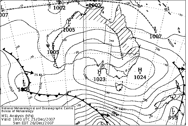
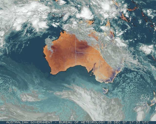
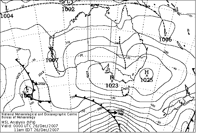
|
For notes on how to interpret
the data and quality control issues, see Daily Weather Summary Help.
**S** and **W** precede data flagged by the Bureau as suspicious or wrong
Data is as received at 01:45EST, 15/05/2012.
|
|
| |
Max
°
C |
+/- norm
°
C |
Min
°
C |
+/- norm
°
C |
Grass Min
°
C |
Rain to 9am mm |
Evaporation to 9am mm |
Sunshine hours |
Wind Run to 9am km (24-hour average km/h) |
Maximum Gust km/h / hour of occurrence |
| GERALDTON AIRPORT |
41.4 |
+11.9 |
22.9 |
+6.6 |
20.1 |
0.0 |
15.6 |
-- |
465 (19.4) |
58/15 |
| PERTH AIRPORT |
44.5 |
+15.6 |
21.6 |
+6.8 |
18.6 |
0.0 |
12.2 |
13.3 |
423 (17.6) |
48/09 |
| ALBANY AIRPORT |
38.6 |
+15.5 |
14.4 |
+2.0 |
10.5 |
0.0 |
9.0 |
13.5 |
341 (14.2) |
-- |
| BUNBURY |
38.6 |
+11.5 |
17.9 |
+4.6 |
-- |
0.0 |
-- |
-- |
258 (10.8) |
22/11 |
| MANDURAH |
38.0 |
-- |
24.1 |
-- |
-- |
0.0 |
-- |
-- |
327 (13.6) |
35/11 |
| DARWIN AIRPORT |
30.2 |
-2.4 |
23.5 |
-1.8 |
23.0 |
18.6 |
3.6 |
1.9 |
294 (12.3) |
34/00 |
| ALICE SPRINGS AIRPORT |
33.5 |
-1.9 |
15.8 |
-4.4 |
13.3 |
0.0 |
15.4 |
13.1 |
414 (17.3) |
52/16 |
| WHYALLA AERO |
29.6 |
+1.5 |
12.2 |
-3.6 |
-- |
0.0 |
-- |
-- |
321 (13.4) |
35/17 |
| ADELAIDE (KENT TOWN) |
29.5 |
+2.5 |
16.8 |
+1.3 |
12.9 |
0.0 |
-- |
12.9 |
282 (11.8) |
34/16 |
| MOUNT GAMBIER AERO |
26.2 |
+3.3 |
5.1 |
-4.8 |
0.2 |
0.0 |
5.6 |
12.4 |
302 (12.6) |
39/15 |
| MOUNT ISA AERO |
35.3 |
-1.9 |
22.7 |
-0.4 |
21.4 |
0.0 |
8.6 |
7.2 |
328 (13.7) |
34/17 |
| CAIRNS AERO |
32.6 |
+1.2 |
24.5 |
+1.1 |
22.9 |
0.2 |
7.6 |
4.8 |
371 (15.5) |
37/09 |
| TOWNSVILLE AERO |
27.3 |
-4.2 |
22.4 |
-1.7 |
22.5 |
54.4 |
10.8 |
0.0 |
495 (20.6) |
48/16 |
| MACKAY M.O |
26.6 |
-3.5 |
24.1 |
+1.2 |
-- |
52.4 |
-- |
0.0 |
570 (23.8) |
58/04 |
| ROCKHAMPTON AERO |
27.3 |
-4.8 |
22.7 |
+1.5 |
22.1 |
0.0 |
8.6 |
-- |
517 (21.5) |
45/11 |
| BUNDABERG AERO |
27.2 |
-2.2 |
21.2 |
+0.7 |
-- |
0.2 |
7.6 |
-- |
558 (23.3) |
57/11 |
| NAMBOUR DPI |
25.0 |
-4.2 |
19.0 |
+0.8 |
-- |
0.0 |
-- |
-- |
-- |
-- |
| COOLANGATTA |
25.3 |
-1.9 |
19.3 |
-0.6 |
-- |
2.4 |
-- |
-- |
402 (16.8) |
54/11 |
| BRISBANE AERO |
27.0 |
-1.3 |
22.6 |
+2.5 |
20.1 |
0.0 |
9.0 |
1.2 |
449 (18.7) |
37/08 |
| TOOWOOMBA AIRPORT |
20.4 |
-7.3 |
15.7 |
-1.0 |
-- |
0.0 |
-- |
-- |
828 (34.5) |
37/14 |
| GUNNEDAH RESOURCE CENTRE |
27.8 |
-3.2 |
16.5 |
-1.0 |
14.9 |
0.0 |
7.4 |
-- |
278 (11.6) |
-- |
| COFFS HARBOUR MO |
22.9 |
-3.4 |
17.5 |
-0.6 |
17.0 |
46.4 |
1.2 |
0.0 |
346 (14.4) |
34/03 |
| PORT MACQUARIE AIRPORT AWS |
24.1 |
-2.5 |
16.3 |
-0.4 |
-- |
0.0 |
-- |
-- |
-- |
-- |
| WILLIAMTOWN RAAF |
24.1 |
-3.1 |
13.4 |
-3.1 |
11.4 |
0.4 |
2.8 |
10.4 |
303 (12.6) |
37/14 |
| GOSFORD (NARARA RESEARCH STATION) AWS |
24.3 |
-2.6 |
12.4 |
-2.9 |
-- |
0.0 |
-- |
-- |
145 ( 6.0) |
28/16 |
| ORANGE AGRICULTURAL INSTITUTE |
22.1 |
-2.3 |
9.3 |
-2.0 |
6.5 |
0.0 |
5.0 |
10.0 |
-- |
-- |
| DUBBO AIRPORT AWS |
25.6 |
-5.9 |
15.6 |
-0.3 |
-- |
0.0 |
-- |
-- |
-- |
-- |
| SYDNEY AIRPORT AMO |
25.3 |
-0.4 |
16.1 |
-1.4 |
10.6 |
0.0 |
5.8 |
12.3 |
477 (19.9) |
50/18 |
| RICHMOND RAAF |
26.5 |
-2.2 |
13.6 |
-2.4 |
-- |
0.0 |
-- |
-- |
163 ( 6.8) |
31/15 |
| BELLAMBI AWS |
22.3 |
-1.8 |
13.6 |
-3.9 |
-- |
0.0 |
-- |
-- |
331 (13.8) |
50/16 |
| CANBERRA AIRPORT |
26.3 |
+0.2 |
9.8 |
-1.6 |
7.1 |
0.0 |
5.2 |
13.0 |
271 (11.3) |
41/14 |
| WAGGA WAGGA AMO |
29.5 |
+0.1 |
14.4 |
+0.7 |
12.9 |
0.0 |
7.2 |
12.4 |
285 (11.9) |
41/23 |
| ALBURY AIRPORT AWS |
28.9 |
-0.5 |
12.7 |
-1.0 |
-- |
0.0 |
-- |
-- |
121 ( 5.0) |
28/14 |
| MILDURA AIRPORT |
30.7 |
+0.6 |
13.0 |
-1.8 |
11.1 |
0.0 |
11.8 |
13.7 |
385 (16.0) |
35/16 |
| TATURA INST SUSTAINABLE AG |
29.0 |
+1.6 |
8.8 |
-3.4 |
-- |
0.0 |
-- |
-- |
438 (18.3) |
30/20 |
| BENDIGO AIRPORT |
28.4 |
+1.4 |
8.6 |
-2.9 |
-- |
0.0 |
-- |
-- |
436 (18.2) |
�
34/21 |
| MELBOURNE REGIONAL OFFICE |
25.6 |
+1.4 |
11.5 |
-1.4 |
7.8 |
0.0 |
5.0 |
-- |
154 ( 6.4) |
18/11 |
| GEELONG AIRPORT |
22.3 |
-0.6 |
7.1 |
-3.8 |
-- |
0.0 |
-- |
-- |
292 (12.2) |
34/18 |
| BALLARAT AERODROME |
24.7 |
+2.1 |
7.7 |
-1.7 |
-- |
0.0 |
-- |
-- |
544 (22.7) |
39/19 |
| LAUNCESTON (TI TREE BEND) |
20.3 |
-2.1 |
8.8 |
-1.8 |
-- |
0.0 |
-- |
-- |
159 ( 6.6) |
50/14 |
| HOBART AIRPORT |
21.0 |
+0.4 |
9.7 |
-1.0 |
6.0 |
0.0 |
4.6 |
8.0 |
363 (15.1) |
48/09 |
| |
Max
°
C |
+/- norm
°
C |
Min
°
C |
+/- norm
°
C |
Grass Min
°
C |
Rain to 9am mm |
Evaporation to 9am mm |
Sunshine hours |
Wind Run to 9am km |
Maximum Gust km/h / hour of occurrence |
|
| Hottest |
| Highest maximum temperature> | Greatest variation above normal maximum |
Highest minimum temperature | Greatest variation above normal minimum |
45.3 GINGIN AERO Lower West WA
45.0 MEDINA RESEARCH CENTRE Lower West WA
44.5 CARNAMAH Central West WA
44.5 PERTH AIRPORT Lower West WA
|
+18.7 : 43.0 HOPETOUN NORTH Lower West WA
+16.9 : 45.0 MEDINA RESEARCH CENTRE Lower West WA
+16.6 : 40.4 PEMBERTON Lower West WA
+16.5 : 41.0 SHANNON Lower West WA
+16.4 : 41.1 MANJIMUP Lower West WA
+16.4 : 41.8 ROCKY GULLY Lower West WA
|
29.6 MULLEWA Central West WA
28.9 MORAWA AIRPORT Central West WA
28.7 CARNAMAH Central West WA
28.6 KARRATHA AERO E Pilbara WA
28.1 MOUNT MAGNET AERO E Gascoyne WA
|
+13.2 : 28.0 BADGINGARRA RESEARCH STN Lower West WA
+12.7 : 28.7 CARNAMAH Central West WA
+12.7 : 29.6 MULLEWA Central West WA
+12.1 : 27.6 JURIEN BAY Lower West WA
+11.8 : 28.9 MORAWA AIRPORT Central West WA
|
| Coldest |
| Lowest maximum temperature | Greatest variation below normal maximum |
Lowest minimum temperature | Greatest variation below normal minimum |
8.3 MOUNT READ W Coast TAS
9.6 HARTZ MOUNTAIN (KEOGHS PIMPLE) Southeast TAS
9.8 MOUNT WELLINGTON Southeast TAS
12.7 MT HOTHAM Upper NE VIC
12.7 LAKE ST CLAIR NATIONAL PARK Central Plateau TAS
|
-13.1 : 22.0 BREWARRINA HOSPITAL Upper Darling NSW
-12.0 : 21.7 COONAMBLE COMPARISON CW Plains N NSW
-11.4 : 21.8 COONAMBLE AIRPORT AWS CW Plains N NSW
-10.5 : 22.7 INJUNE POST OFFICE Maranoa QLD
-10.0 : 23.8 MITCHELL POST OFFICE Maranoa QLD
|
-2.5 THREDBO VILLAGE Snowy Mtns NSW
-1.0 LIAWENEE Central Plateau TAS
0.4 LAKE ST CLAIR NATIONAL PARK Central Plateau TAS
1.4 THREDBO AWS Snowy Mtns NSW
1.7 MT BAW BAW W Gippsland VIC
1.7 MOUNT WELLINGTON Southeast TAS
|
**S** -10.7 : 12.5 BEDOURIE POLICE STATION Channel Country QLD
-7.8 : -2.5 THREDBO VILLAGE Snowy Mtns NSW
-6.9 : 3.0 NARACOORTE AERODROME Lower SE SA
-6.7 : 3.3 COONAWARRA Lower SE SA
-6.5 : 4.3 PORTLAND (CASHMORE AIRPORT) W Coast VIC
|
|
Sunniest &
dullest |
Windiest |
Highest gusts |
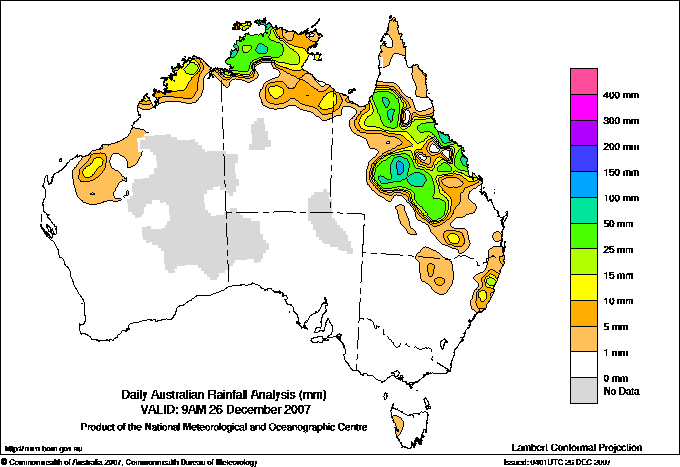
Todays highest rainfall totals for the 24 hours to 9am. It
includes the top 5 totals nationally followed by all reported falls of 50mm or more. |
Highest
and lowest recordings of hours of sunshine for the 24 hours to midnight. |
Highest wind
run totals in kilometres for the 24 hours to 9am (average speed in brackets).
All reported runs >
=25km/h are shown. |
Highest wind
gusts in km/h for the 24 hours to midnight followed by the hour in which it occurred.
All stations with gusts >
89km/h are shown. |
170.0 COREENA Central West QLD
155.8 EVERSLEIGH Central West QLD
151.0 LERIDA Central West QLD
148.0 MIRANI MARY STREET Central Coast E QLD
141.0 PLEYSTOWE SUGAR MILL Central Coast E QLD
NORTHERN TERRITORY
N Rivers
130.6 BLACK POINT
114.6 MCCLUER ISLAND
98.2 CHANNEL POINT
85.0 WUDIKAPILDIYERR
79.0 SEVEN SPIRIT BAY
70.0 MCMINNS LAGOON
62.8 JINDARE
62.0 MARY RIVER RANGERS
60.2 HUMPTY DOO COLLARD ROAD
53.2 THE CHASE
52.8 HUMPTY DOO FIRE STATION
50.8 ROSEBERY
50.2 BONALBO
50.0 CAPE WILBERFORCE
QUEENSLAND
Gulf Country
68.4 MAGOWRA STATION
56.4 PORMPURAAW TOWNSHIP
50.0 RUTLAND PLAINS STATION
Upper Carpentaria
53.4 ZARA STATION
N Coast--Barron
106.2 HOPE VALE
N Coast--Herbert
91.2 PALM ISLAND WATER TREAT
90.0 CARDWELL RANGE
70.6 ORPHEUS ISLAND RESORT
70.0 MAGNETIC ISLAND - NELLY BAY
54.4 TOWNSVILLE AERO
Central Coast E
148.0 MIRANI MARY STREET
141.0 PLEYSTOWE SUGAR MILL
120.0 DUMBLETON ROCKS ALERT
93.0 GARGETT ALERT
87.0 MACKAY AERO
85.6 ALVA BEACH
84.0 MIRANI WEIR ALERT
82.0 BELGAMBA
80.0 MIRANI WEIR TM
77.0 PLANE CREEK SUGAR MILL
76.0 GIRU NORTH
70.0 KOUMALA HATFIELDS ROAD
70.0 ORKABIE WEST HILL
70.0 CREDITON
64.0 MACKAY ALERT
60.4 AYR DPI RESEARCH STN
57.0 DALRYMPLE HEIGHTS
56.0 INKERMAN BRIDGE ALERT
55.0 BOWEN PUMP STATION ALERT
55.0 POWERLINE TM
55.0 SHIRBOURNE PARK
54.0 EAST MACKAY
53.2 MAJORS CREEK
52.4 MACKAY M.O
50.0 GUMLU DAYS ROAD
Central Coast W
63.6 OXFORD DOWNS
Central Highlands
53.0 DUNEIRA
50.4 BETANGA
Central West
170.0 COREENA
155.8 EVERSLEIGH
151.0 LERIDA
100.6 ARAMAC POST OFFICE
95.0 BEACONSFIELD
90.0 LANDSBOROUGH DOWNS
68.0 AMBO STATION
66.0 FRANKFIELD STATION
64.0 EVESHAM STATION
63.6 GUE
55.0 BIRRICANNIA
54.0 LUTHRIE
53.0 LOCHNAGAR
Northwest
134.0 MAHRIGONG
75.6 BELMONT
54.0 WINTON AIRPORT
51.8 WINTON POST OFFICE
Channel Country
60.0 KEEROONGOOLOO
Warrego
52.0 LOCHINVAR
|
13.7 NURIOOTPA VITICULTURAL Adelaide/Lofty SA
13.7 MILDURA AIRPORT Mallee N VIC
13.6 WOOMERA AERODROME NW Pastoral SA
13.5 ALBANY AIRPORT Lower West WA
13.4 CEDUNA AMO W Agricultural SA
.....
0.4 STRATHGORDON VILLAGE W Coast TAS
0.4 ALSTONVILLE TROPICAL FRUIT RESEARCH STAT North Coast NSW
0.0 TOWNSVILLE AERO N Coast--Herbert QLD
0.0 MACKAY M.O Central Coast E QLD
**W** 0.0 WARWICK Darling Downs E QLD
0.0 COFFS HARBOUR MO MidNorth Coast N NSW
|
1204 (50.2) RUNDLE ISLAND Wide Bay/Burnett QLD
1067 (44.5) DOUBLE ISLAND POINT LIGHTHOUSE Brisbane/SE Coast QLD
1066 (44.4) MAATSUYKER ISLAND LIGHTHOUSE Southeast TAS
1029 (42.9) CAPE MORETON LIGHTHOUSE Brisbane/SE Coast QLD
969 (40.4) LADY ELLIOT ISLAND Wide Bay/Burnett QLD
943 (39.3) HAMILTON ISLAND AIRPORT Central Coast E QLD
855 (35.6) BYRON BAY (CAPE BYRON AWS) North Coast NSW
853 (35.5) HARTZ MOUNTAIN (KEOGHS PIMPLE) Southeast TAS
845 (35.2) HERON ISLAND RES STN Wide Bay/Burnett QLD
828 (34.5) TOOWOOMBA AIRPORT Darling Downs E QLD
778 (32.4) GOLD COAST SEAWAY Brisbane/SE Coast QLD
702 (29.3) GLADSTONE RADAR Wide Bay/Burnett QLD
701 (29.2) MURRURUNDI GAP AWS Hunter Valley NSW
700 (29.2) CAPE GRIM BAPS N Coast TAS
693 (28.9) YEPPOON THE ESPLANADE Central Coast E QLD
680 (28.3) MAROOCHYDORE AERO Brisbane/SE Coast QLD
670 (27.9) HOGAN ISLAND Islands ISL
627 (26.1) FLINDERS ISLAND AIRPORT Flinders Is/Bass St TAS
619 (25.8) OAKEY AERO Darling Downs E QLD
615 (25.6) GABO ISLAND LIGHTHOUSE E Gippsland VIC
|
100/16 MAATSUYKER ISLAND LIGHTHOUSE Southeast TAS
93/15 HARTZ MOUNTAIN (KEOGHS PIMPLE) Southeast TAS
91/20 MOUNT WELLINGTON Southeast TAS
83/04 HAMILTON ISLAND AIRPORT Central Coast E QLD
83/12 SCOTTS PEAK DAM W Coast TAS
|
�