Thursday 28 JUN 2007
 

Home page

DWS ARCHIVE
2024 2023 2022 2021 2020 2019 2018 2017 2016 2015 2014 2013 2012 2011 2010 2009 2008 2007 2006 2005 2004 2003
Before 2003

About the DWS


2007

Dec

M Tu W Th F Sa Su
          01 02
03 04 05 06 07 08 09
10 11 12 13 14 15 16
17 18 19 20 21 22 23
24 25 26 27 28 29 30
31            

Nov

M Tu W Th F Sa Su
      01 02 03 04
05 06 07 08 09 10 11
12 13 14 15 16 17 18
19 20 21 22 23 24 25
26 27 28 29 30    

Oct

M Tu W Th F Sa Su
01 02 03 04 05 06 07
08 09 10 11 12 13 14
15 16 17 18 19 20 21
22 23 24 25 26 27 28
29 30 31        

Sept

M Tu W Th F Sa Su
          01 02
03 04 05 06 07 08 09
10 11 12 13 14 15 16
17 18 19 20 21 22 23
24 25 26 27 28 29 30

August

M Tu W Th F Sa Su
    01 02 03 04 05
06 07 08 09 10 11 12
13 14 15 16 17 18 19
20 21 22 23 24 25 26
27 28 29 30 31    

July

M Tu W Th F Sa Su
            01
02 03 04 05 06 07 08
09 10 11 12 13 14 15
16 17 18 19 20 21 22
23 24 25 26 27 28 29
30 31          

June

M Tu W Th F Sa Su
        01 02 03
04 05 06 07 08 09 10
11 12 13 14 15 16 17
18 19 20 21 22 23 24
25 26 27 28 29 30  

May

M Tu W Th F Sa Su
  01 02 03 04 05 06
07 08 09 10 11 12 13
14 15 16 17 18 19 20
21 22 23 24 25 26 27
28 29 30 31      

April

M Tu W Th F Sa Su
            01
02 03 04 05 06 07 08
09 10 11 12 13 14 15
16 17 18 19 20 21 22
23 24 25 26 27 28 29
30            

March

M Tu W Th F Sa Su
      01 02 03 04
05 06 07 08 09 10 11
12 13 14 15 16 17 18
19 20 21 22 23 24 25
26 27 28 29 30 31  

February

M Tu W Th F Sa Su
      01 02 03 04
05 06 07 08 09 10 11
12 13 14 15 16 17 18
19 20 21 22 23 24 25
26 27 28        

January

M Tu W Th F Sa Su
01 02 03 04 05 06 07
08 09 10 11 12 13 14
15 16 17 18 19 20 21
22 23 24 25 26 27 28
29 30 31        

Monthly summaries:
from BoM

Find a place:
Google Maps |
Aust Gazetteer|
Geonames

Weather terms:
WeatherZone | BoM |
American Met Soc | NOAA | uk.sci.weather | India Meteorological Department

National Daily Weather Summary

Records set | Charts | Cities | Hottest | Coldest | Rain, sun & wind | Downpours & gales
State extremes | Noteworthy weather | Capital Cities | Regional Cities | Alpine Stations
Charts and data courtesy Bureau of Meteorology. MTSAT-1R operated by JMA
Noteworthy weather today
significant newsworthy major

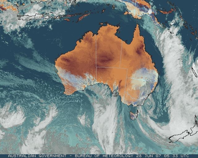
Flood situation at 7.30 this morning, showing major flooding moving down the Latrobe, Thomson, Macalister, Avon and Mitchell Rivers.

The Latrobe, Thomson, Macalister and Avon Rivers emerge from mountainous country onto the flat plains to the west and north of Sale where they meander and converge through multiple channels before emptying into Lake Wellington, the large body of water SE of Stratford on the map. Lake Wellington is part of the Gippsland Lakes complex that lies behind Ninety Mile Beach, which is the long, smooth coastline to the SE of Stratford and Bairnsdale. The Avon enters Lake Wellington east of Stratford. The Mitchell, Nicholson and Tambo Rivers enter the Gippsland Lakes complex via Lake King to the SE of Bairnsdale. The only exit to Bass Strait for all these rivers and the Gippsland Lakes complex is a 150m wide channel at Lakes Entrance.

The flood peak moving down the Latrobe came from torrential rain in Traralgon Creek, to the south of Traralgon, and strong flows from the Tanjil River to the northwest. Thomson Dam, in the upper reaches of the Thomson River, impounds the main water reservoir for Melbourne. Lake Glenmaggie is a major impoundment on the Macalister River, 15km west of Maffra. The Macalister meets the Thomson just northwest of Sale, which in turn flows into the Latrobe just south of Sale before entering tidal Lake Wellington.

VIC: Gippsland flooding worsens

Rain eased across West Gippsland late this morning (see yesterday's report on rainfall for this event). However, falls of 150 to 300mm across West Gippsland, mostly within a 24-hour period, have produced river flows unseen since the 1990 or 1998 floods.

In East Gippsland, rain increased as the second of the pair of East Coast Lows approached the SE corner of the continent. Rain fell through the day, with the highest falls of around 50 to 60mm causing renewed rises in East Gippsland streams.

The map at right shows the main West Gippsland flood situation at 7.30 this morning, while the caption gives a quick summary of the layout of the rivers and Gippsland Lakes system which may help understanding of why floods in this area are complicated affairs.

Flood levels in West Gippsland began to fall in mountain areas soon after rain eased. However, as river flows emerged onto the plains to the north and west of Sale and around Bairnsdale, it became clear that water volumes would equal or exceed the 1998 and 1990 floods on some rivers.

Dozens of main roads became or remained closed today because of flooding, trees or powerlines across the road or landslips. 9,500 properties remained without power this morning, with the repair process slowed by blocked roads, atrocious weather conditions, and the need to give priority to fallen live wires.

Today's situation, river by river:

  • Latrobe River: Floodwaters entering the Latrobe from Traralgon Creek and Tanjil River gave river peaks just under minor flood level at Willow Grove, Thoms Bridge and Rosedale late this evening/early Friday morning. Several properties in Traralgon were under water from the flooding Traralgon Creek.
  • Thomson River: Outflows from Cowwarr Weir exceeded major flood level (45,000 ML/Day) about 10.30 Wednesday night and peaked at 73,798 ML/Day around 4 or 5 this morning. At Wandocka, the river peaked at 6.74m around midday, just above major flood level (6.7m) but slightly below the flood peaks of floods of June 1978 and April 1990. The river started to rise at Sale early this afternoon and peaked at 4.23m around 5am Friday morning (major flood level is 4.0m).
  • Macalister River: River gauges upstream of Lake Glenmaggie have been washed away, but major flooding occurred at Licola and moderate to major flooding elsewhere causing major damage in the upper Macalister valley. Bureau spokesman Ian Baker told ABC Radio "It's certainly looking as though it'll be the biggest flood we've recorded on the upper Macalister." Lake Glenmaggie has filled rapidly from low levels and began to spill late Wednesday evening. By 1.30 this morning outflow was already above the moderate flood level of 22,000 ML/Day. The outflow rate rose rapidly to a record peak of 147,000 ML/Day at 10am -- major flood level is 35,000 ML/Day! This is higher than the flows in the January 1971 flood event. The outflow rate did not drop below major flood level until about 8am Friday. Water flowed over the spillway with such force that it nearly demolished a power generating building near the base of the dam wall. The small settlement of Newry, on the flood plain 8km below Glenmaggie Dam, bore the brunt of the unexpected massive outflow. All roads to the settlement were closed and police used helicopters to winch residents to safety in addition to Zodiac boats brought in by Melbourne water police. Over 60 people were rescued from the settlement and outlying areas. Cows and horses were swept away in the Glenmaggie and Maffra areas, with 200 cattle lost on one property. Livestock loss and property damage are expected to be widespread.
  • Avon River: The Avon peaked at The Channel at 9.30 yesterday evening at a height of 9.6m, well below the April 1990 flood peak of 11.22m. At the same time, the river exceeded major flood level at Stratford (6.5m) and rose rapidly to peak at 8.9m about 1am. The 1990 flood at Stratford peaked at 9.0m. The Princes Highway was blocked just north of Stratford with all practicable alternative roads flooded and only high-clearance vehicles allowed through. Stratford Caravan Park was evacuated last night along with about 40 residents from houses.
  • Mitchell River: River gauges upstream from Glenaladale on both the Mitchell and Dargo Rivers have been washed away. At Glenaladale, the river peaked at 8.22m around midday (major flood level is 5.5m). At Bairnsdale, the river peaked overnight into Friday, with readings at the Pumphouse of 7.66m at 6pm today and 7.45m at 9am Friday and, apparently, no measurement of the peak. During April 1990 Bairnsdale Pumphouse peaked at 7.84 metres and during June 1998 at 7.75 metres. The Bairnsdale caravan park was evacuated this morning, and another 1220 people were reported being evacuated from homes. Bairnsdale residents were amazed to see a complete house, which had been in the process of being removed from a property, float down the river. The Princes Highway was cut.
  • Nicholson River: No gauge data available, but flooding estimated to be moderate to major.
  • Tambo River: By late afternoon, the Tambo was above moderate level and rising.
  • Buchan River: Minor flooding
  • Snowy River: Minor flooding was occurring along most of the river, with rises to moderate and, in some places, major flooding expected on Friday.
  • Cann River: Both branches remained at minor flood level through the day. The West Branch peaked at 2.45m at Weeragua at midnight this evening. The East Branch peaked at 2.33 at Chandlers Creek at 11.45pm.
  • Genoa River: remained at minor flood level. It peaked at The Gorge at 2.53m around 8.38pm.

WA: Heavy rain in the South West

Somewhat overshadowed by events on the other side of the continent, WA's South West recorded general heavy rain overnight with the passage of a front. Jarrahwood's 76.6mm was its heaviest June one-day fall in 32 years. The highest official total was 83mm at Paynedale, 30km E of Busselton, though radio reports said some areas near Paynedale recorded over 100mm. Totals of 10 to 25mm were recorded farther north along the coast to Carnarvon, and inland to the Great Southern. But the rain missed inland agricultural areas where farmers had been hoping for follow-up rain this week. Details in wettest and records.

WA, QLD: More temperature records fall

Temperature records high and low fell on either side of the continent today. Kalbarri and Denham on the WA central coast set record high minima in warm northwesterlies ahead of the front that brought heavy rain farther south. In QLD, cold air surging up from NSW set record low maxima on the Darling Downs and on the coast near Brisbane. Gladstone also recorded its coldest June night in 13 years. Details in records.

Prs Ext Rec Not War Rdr Cht Rfl Rec


Records set or equalled today

These records are based on data received as at 0649 EST on 21/08/2008. Help in interpreting these statistics and information on quality control is here.

District Site Today Previous monthly record Previous all time record
if equalled or broken
Comments
Reading Reading Date Years Reading Date Years
Highest daily rainfall

WA

SW & S Coast

009842

JARRAHWOOD

76.6

65.0

19/06/1997

32

1 y

WA

SW & S Coast

009916

CRENDON

64.0

64.0

28/06/1983

34

1 y Equal to record.

VIC

Upper NE

083033

WOODS POINT

101.0

80.0

29/06/1980

114

1 y

VIC

W Gippsland

085034

GLENMAGGIE WEIR

77.6

68.2

03/06/1978

69

1 y

VIC

W Gippsland

085168

BRIAGOLONG

85.0

78.0

03/06/1978

40

1 y

VIC

W Gippsland

085236

CALLIGNEE NORTH

144.0

75.0

29/06/1980

51

92.0

22/03/1983

51

1 y

VIC

W Gippsland

085238

ERICA (PARKERS CORNER)

138.2

107.0

03/06/1978

45

133.4

30/01/1971

47

1 y

VIC

W Gippsland

085277

NOOJEE (SLIVAR)

59.4

47.2

11/06/1989

26

1 y

VIC

W Gippsland

085278

ABERFELDY (LILY CREEK (LAROMMI))

165.4

54.4

23/06/1998

25

122.2

03/02/2005

25

1 y

VIC

W Gippsland

085289

MURDERERS HILL

186.0

135.4

17/06/2002

18

1 n

VIC

W Gippsland

085292

NOOJEE FORESTRY

68.0

50.0

04/06/1996

18

1 y

VIC

W Gippsland

085295

STONY CREEK

45.4

42.3

17/06/2005

15

1 y

VIC

W Gippsland

085296

MT MOORNAPA

123.4

115.0

23/06/1998

13

1 n

VIC

W Gippsland

085299

KOORNALLA TRARALGON CK RD

130.2

29.2

21/06/2007

14

64.0

03/02/2005

14

1 y Previous record set earlier this month.

VIC

E Central

086094

POWELLTOWN DNRE

115.0

69.9

26/06/1959

65

1 y

VIC

E Central

086271

REEFTON (UPPER YARRA DAM)

74.2

48.0

11/06/1989

36

1 y

VIC

E Central

086363

TARRAWARRA

25.8

24.4

25/06/1998

16

1 y

TAS

E Coast

092113

BEAUMARIS (SKYLINE DRIVE)

26.6

21.8

22/06/1998

11

1 n

TAS

W Coast

097065

TAHUNE RESERVE

57.0

35.6

12/06/1985

30

1 n

Highest grass minimum temperature

WA

W Gascoyne

006044

DENHAM

18.0

17.9

22/06/2004

19

1 Y

Highest minimum temperature

WA

W Gascoyne

006044

DENHAM

20.0

19.6

07/06/2007

19

1 Y Previous record set earlier this month.

WA

Central West

008251

KALBARRI

18.9

18.5

20/06/1996

33

1 Y

Lowest minimum temperature

QLD

Wide Bay/Burnett

039326

GLADSTONE AIRPORT

5.2

5.6

01/06/2000

13

1 Y

Lowest maximum temperature

QLD

N Coast--Barron

031192

GREEN ISLAND

19.0

19.0

27/06/2007

12

1 P Equal to record. Previous record set earlier this month.

QLD

Brisbane/SE Coast

040209

POINT LOOKOUT

16.0

16.1

23/06/1998

11

1 P

QLD

Darling Downs E

041095

STANTHORPE LESLIE PARADE

5.0

5.0

20/06/2007

45

1 P Equal to record. Previous record set earlier this month.

QLD

Darling Downs E

041525

WARWICK

9.1

9.1

20/06/2007

12

1 Y Equal to record. Previous record set earlier this month.

Highest daily average wind speed - anemometer above 3m (km/h)

VIC

Mallee N

076031

MILDURA AIRPORT

25.8

24.3

08/06/2001

14

1 Y

VIC

Upper North

081049

TATURA INST SUSTAINABLE AG

36.3

35.0

28/06/1981

31

1 Y

VIC

W Gippsland

085072

EAST SALE AIRPORT

39.7

35.6

14/06/2003

12

1 Y


The day in charts
Surface charts Satellite images Rain & temperatures
4am EST Rainfall -- 24 hours to 9am
Available about 6am EST Available about 4am EST Available about 2pm EST
Week to 9am | SE AUS detail
10am EST Minimum temperature +/- normal
Available about noon EST Available about 10am EST Available about 2pm EST next day
Actual temperatures
4pm EST Maximum temperature +/- normal
Available about 6pm EST Available about 4pm EST Available about 2pm EST next day
Actual temperatures
10pm EST Solar Radiation
Available about midnight EST Available about 10pm EST Available about 2am EST next day

Summary of observations

For notes on how to interpret the data and quality control issues, see Daily Weather Summary Help.
**S** and **W** precede data flagged by the Bureau as suspicious or wrong
Data is as received at 00:50EST, 15/05/2012.

Major centres
Max
° C
+/- norm
° C
Min
° C
+/- norm
° C
Grass Min
° C
Rain to 9am mm Evaporation to 9am mm Sunshine hours Wind Run to 9am km (24-hour average km/h) Maximum Gust km/h / hour of occurrence
GERALDTON AIRPORT 22.2 +1.3 16.9 +5.9 14.7 5.2 3.4 -- 613 (25.5) 45/00
PERTH AIRPORT 20.6 +1.7 12.3 +3.3 11.8 12.2 2.2 5.7 -- 37/13
ALBANY AIRPORT 17.7 +1.1 11.5 +3.4 9.3 8.8 3.8 7.1 710 (29.6) 58/01
BUNBURY 19.2 +0.8 12.3 +4.2 -- 52.2 -- -- 519 (21.6) 54/00
MANDURAH 19.4 -- 13.3 -- -- 26.6 -- -- 813 (33.9) 50/04
DARWIN AIRPORT 27.0 -3.6 15.2 -4.7 13.6 0.0 7.6 11.0 478 (19.9) 46/10
ALICE SPRINGS AIRPORT 17.8 -2.0 0.4 -4.7 -3.1 0.0 3.2 10.4 285 (11.9) 34/12
WHYALLA AERO 14.2 -3.1 6.6 +0.5 -- 1.0 1.8 -- 295 (12.3) 24/12
ADELAIDE (KENT TOWN) 16.3 +0.2 8.2 +0.1 7.7 1.2 1.0 5.8 273 (11.4) 30/10
MOUNT GAMBIER AERO 12.5 -1.3 8.4 +2.6 6.4 0.6 0.8 0.3 553 (23.0) 34/09
MOUNT ISA AERO 18.4 -6.5 2.4 -7.6 0.7 0.0 4.0 10.2 348 (14.5) 39/11
CAIRNS AERO 21.6 -4.4 12.4 -5.4 8.9 0.0 6.4 10.8 392 (16.3) 26/03
TOWNSVILLE AERO 21.3 -4.3 11.3 -3.3 5.5 0.0 6.0 10.8 449 (18.7) 55/09
MACKAY M.O 19.9 -2.0 8.8 -5.2 -- 0.0 -- 10.3 312 (13.0) 35/10
ROCKHAMPTON AERO 18.9 -4.6 4.7 -6.2 0.7 0.0 3.2 -- 249 (10.4) 34/16
BUNDABERG AERO 18.0 -4.6 5.4 -6.2 -- 0.0 2.2 -- 335 (14.0) 39/10
NAMBOUR DPI 16.6 -5.0 2.2 -7.1 -- 0.2 0.8 -- 92 ( 3.8) 35/14
COOLANGATTA 17.1 -4.0 3.6 -7.9 -- 0.2 -- -- 231 ( 9.6) 50/13
BRISBANE AERO 16.4 -4.9 5.5 -5.0 2.0 0.0 5.4 7.9 539 (22.5) 41/16
TOOWOOMBA AIRPORT 7.1 -9.9 3.2 -4.3 -- 0.0 -- -- 651 (27.1) 50/18
GUNNEDAH RESOURCE CENTRE 11.7 -5.1 5.6 -0.5 4.8 2.0 1.6 -- 449 (18.7) --
COFFS HARBOUR MO 17.2 -2.2 4.5 -4.6 2.4 0.0 2.4 6.7 329 (13.7) 45/13
PORT MACQUARIE AIRPORT AWS 17.2 -2.3 4.9 -3.1 -- 0.0 -- -- -- --
WILLIAMTOWN RAAF 14.5 -3.1 6.2 -1.7 5.5 0.0 2.8 7.0 718 (29.9) 52/13
GOSFORD (NARARA RESEARCH STATION) AWS 14.8 -3.1 4.1 -2.4 -- 2.0 -- -- 184 ( 7.7) 24/13
ORANGE AGRICULTURAL INSTITUTE 7.8 -2.7 0.4 -2.2 -1.0 30.0 0.0 1.9 -- --
DUBBO AIRPORT AWS 12.3 -4.1 4.9 +0.3 -- 17.0 -- -- -- --
SYDNEY AIRPORT AMO 14.9 -2.7 5.6 -2.9 2.5 0.0 2.0 2.4 546 (22.8) 39/13
RICHMOND RAAF 12.9 -5.1 3.3 -1.6 -- 0.2 -- -- 226 ( 9.4) 31/12
BELLAMBI AWS 15.8 -1.9 6.4 -4.6 -- 0.0 -- -- 286 (11.9) 52/23
CANBERRA AIRPORT 12.7 +0.5 3.9 +2.9 1.7 5.2 0.6 2.2 231 ( 9.6) 50/22
WAGGA WAGGA AMO 16.8 +3.0 3.1 -0.6 0.2 0.4 0.0 3.9 255 (10.6) 45/16
ALBURY AIRPORT AWS 17.1 +2.9 6.0 +2.1 -- 0.0 -- -- 227 ( 9.5) 54/15
MILDURA AIRPORT 17.4 +1.4 6.7 +1.5 6.1 0.0 3.6 9.4 620 (25.8) 52/00
TATURA INST SUSTAINABLE AG 15.7 +1.7 10.8 +7.1 -- 0.0 3.0 -- 872 (36.3) 65/12
BENDIGO AIRPORT 14.9 +1.7 8.9 +5.3 -- 0.0 -- -- 711 (29.6) 63/13
MELBOURNE REGIONAL OFFICE 14.9 +0.9 11.0 +4.1 9.9 12.0 0.0 -- 116 ( 4.8) 21/01
GEELONG AIRPORT 14.6 0.0 10.7 +4.4 -- 0.2 -- -- 870 (36.3) 54/01
BALLARAT AERODROME 11.8 +1.0 6.9 +2.9 -- 4.4 -- -- 941 (39.2) 65/03
LAUNCESTON (TI TREE BEND) 13.7 +0.6 9.8 +6.9 -- 2.8 -- -- 471 (19.6) 55/13
HOBART AIRPORT 12.3 -0.6 4.5 -0.1 9.0 0.6 0.2 0.6 456 (19.0) 32/01
Max
° C
+/- norm
° C
Min
° C
+/- norm
° C
Grass Min
° C
Rain to 9am mm Evaporation to 9am mm Sunshine hours Wind Run to 9am km Maximum Gust km/h / hour of occurrence
Hottest
Highest maximum temperature>Greatest variation above normal maximum Highest minimum temperatureGreatest variation above normal minimum

33.3 PORT KEATS AERO N Rivers NT
29.0 NORTHERN ENDEAVOUR Islands ISL
28.3 COCOS ISLAND AIRPORT Islands ISL
28.1 MIDDLE POINT AWS N Rivers NT

+6.2 : 25.2 LEONORA Goldfields WA
+5.4 : 25.0 YEELIRRIE Goldfields WA
+5.3 : 23.8 LAVERTON AERO Goldfields WA
+5.3 : 24.5 LEINSTER AERO Goldfields WA
+5.1 : 24.7 MEEKATHARRA AIRPORT E Gascoyne WA

25.0 NORTHERN ENDEAVOUR Islands ISL
24.6 COCOS ISLAND AIRPORT Islands ISL
23.9 COCONUT ISLAND N Peninsula QLD
23.5 CHRISTMAS ISLAND AERO Islands ISL
22.6 HORN ISLAND N Peninsula QLD

+9.3 : 16.7 MURCHISON W Gascoyne WA
+7.9 : 18.9 KALBARRI Central West WA
+7.8 : 8.9 FINGAL (LEGGE STREET) E Coast TAS
+7.6 : 9.4 CRESSY RESEARCH STATION N Coast TAS
+7.6 : 14.2 PAYNES FIND E Gascoyne WA

Coldest
Lowest maximum temperatureGreatest variation below normal maximum Lowest minimum temperatureGreatest variation below normal minimum

-0.2 MT HOTHAM Upper NE VIC
-0.1 THREDBO AWS Snowy Mtns NSW
0.7 FALLS CREEK Upper NE VIC
1.0 MOUNT GININI AWS Goulburn/Monaro NSW
1.4 MOUNT BULLER Upper NE VIC

-10.5 : 5.0 STANTHORPE LESLIE PARADE Darling Downs E QLD
-9.9 : 7.1 TOOWOOMBA AIRPORT Darling Downs E QLD
-9.7 : 10.4 DALBY AIRPORT Darling Downs E QLD
-9.7 : 9.6 INGLEWOOD FOREST Darling Downs E QLD
-9.5 : 9.6 OAKEY AERO Darling Downs E QLD

**S** -3.5 GLEN INNES AG RESEARCH STN N Tablelands W NSW
-3.1 ERNABELLA (PUKATJA) NW Pastoral SA
-3.0 MOUNT GININI AWS Goulburn/Monaro NSW
-3.0 TIDBINBILLA NATURE RESERVE Goulburn/Monaro NSW
-2.7 MT HOTHAM Upper NE VIC

-9.0 : 4.0 GEORGETOWN POST OFFICE Upper Carpentaria QLD
-9.0 : 5.3 TINDAL RAAF N Rivers NT
-8.4 : 7.0 MAREEBA AIRPORT N Coast--Barron QLD
-8.4 : 4.5 PROSERPINE AIRPORT Central Coast E QLD
-8.4 : 4.4 ATHERTON SHIRE COUNCIL N Coast--Barron QLD

Wettest
Sunniest & dullest
Windiest
Highest gusts
Todays highest rainfall totals for the 24 hours to 9am. It includes the top 5 totals nationally followed by all reported falls of 50mm or more.
Highest and lowest recordings of hours of sunshine for the 24 hours to midnight.
Highest wind run totals in kilometres for the 24 hours to 9am (average speed in brackets). All reported runs > =25km/h are shown.
Highest wind gusts in km/h for the 24 hours to midnight followed by the hour in which it occurred. All stations with gusts > 89km/h are shown.
318.6 MOUNT WELLINGTON W Gippsland VIC
209.4 REEVES KNOB W Gippsland VIC
186.0 MURDERERS HILL W Gippsland VIC
165.4 ABERFELDY (LILY CREEK (LAROMMI)) W Gippsland VIC
144.0 CALLIGNEE NORTH W Gippsland VIC

WESTERN AUSTRALIA
Lower West
106.0 PAYNEDALE
83.0 PAYNEDALE ALERT
78.2 BOYANUP
76.6 JARRAHWOOD
75.0 PARKFIELD
75.0 PERIVALE ORCHARD
71.8 RAVENSCLIFFE ALERT
70.8 HAPPY VALLEY
70.2 EKAMURRA
64.0 MARRIWOOD
64.0 CRENDON
63.0 BOYANUP NORTH
61.8 GREENBUSHES
61.2 KIRUP
61.0 ROELANDS VILLAGE
60.0 DARDANUP EAST
59.0 ROELANDS
59.0 THIRLMERE
55.0 BALINGUP
53.4 DARDANUP
52.2 BUNBURY
51.2 LUDLOW

NEW SOUTH WALES
South Coast
60.4 NIMMITABEL (KYBEYAN (DOOLONDONDOO))
53.0 WYNDHAM (NYUMBANI)
Goulburn/Monaro
55.2 NIMMITABEL (COTTESLOE)
53.4 HOLTS FLAT (BELLEVUE)
Snowy Mtns
53.6 INGEBYRA (GROSSES PLAINS)

VICTORIA
Upper NE
101.0 WOODS POINT
60.8 MT HOTHAM AIRPORT
52.2 OMEO
50.2 MOUNT BULLER
E Gippsland
79.2 BAIRNSDALE (MITCHELL RIVER @ ROSEHILL)
73.0 BUCHAN (SNOWY RIVER AT D/S BASIN CREEK)
58.6 DARGO
57.8 BRUTHEN (POST OFFICE)
53.0 CLUB TERRACE
52.2 LAKES ENTRANCE (EASTERN BEACH ROAD)
51.0 ORBOST
W Gippsland
318.6 MOUNT WELLINGTON
209.4 REEVES KNOB
186.0 MURDERERS HILL
165.4 ABERFELDY (LILY CREEK (LAROMMI))
144.0 CALLIGNEE NORTH
140.8 TRARALGON CREEK (MOUNT HOOGHLY)
139.0 BALOOK
138.2 ERICA (PARKERS CORNER)
136.0 MOUNT USEFUL
130.2 KOORNALLA TRARALGON CK RD
126.0 ERICA
123.4 MT MOORNAPA
118.2 WALHALLA
116.6 LE ROY (TAYLORS RD QUARRY)
112.6 VESPER
111.8 TRARALGON CREEK AT KOORNALLA
92.6 GLENCAIRN (BARKLY RIVER (GLENVIEW))
85.0 BRIAGOLONG
80.0 AVON RIVER @ THE CHANNEL
77.6 GLENMAGGIE WEIR
77.2 VALENCIA CREEK (LITTLE PLAIN)
71.0 MITCHELL RIVER @ GLENALADALE
70.8 BOOLARRA SOUTH
68.0 NOOJEE FORESTRY
63.8 EAST TARWIN (MIRBOO PASTORAL COMPANY)
62.0 MEERLIEU (SPRINGVALE WEST)
59.4 NOOJEE (SLIVAR)
58.6 MADALYA
55.2 BAIRNSDALE AIRPORT
53.2 STRATFORD
E Central
115.0 POWELLTOWN DNRE
75.4 MAROONDAH WEIR (MELBOURNE WATER)
74.2 REEFTON (UPPER YARRA DAM)
73.0 CORANDERRK BADGER WEIR
57.6 WARBURTON EAST (ARRABRI)
57.0 WARBURTON (O'SHANNASSY RESERVOIR)
52.4 KINGLAKE WEST
52.0 MONBULK (BULB FARM)
51.6 CROYDON (COUNCIL DEPOT)
51.0 CROYDON (SAMUEL STREET)
51.0 SEVILLE (ROMAHILL PIGGERY)
W Central
66.0 HESKETT (STRAWS LANE)
N Central
69.6 KINGLAKE WEST (WALLABY CREEK)
59.2 MARYSVILLE (POST OFFICE)
55.0 TRENTHAM (POST OFFICE)
54.0 MARYSVILLE GOLF COURSE

TASMANIA
W Coast
57.0 TAHUNE RESERVE

ISLANDS

52.0 DONNYBROOK SOUTH

11.0 DARWIN AIRPORT N Rivers NT
10.8 CAIRNS AERO N Coast--Barron QLD
10.8 TOWNSVILLE AERO N Coast--Herbert QLD
10.8 KAIRI RESEARCH STATION N Coast--Barron QLD
10.7 BROOME AIRPORT W Kimberley WA

.....

0.0 WARWICK Darling Downs E QLD
0.0 COBAR MO Upper Darling NSW
0.0 INVERELL RESEARCH CENTRE N Tablelands W NSW
0.0 GROVE (COMPARISON) Southeast TAS
0.0 NORFOLK ISLAND AERO Islands ISL

1617 (67.4) HOGAN ISLAND Islands ISL
1447 (60.3) MOUNT BULLER Upper NE VIC
1371 (57.1) WILSONS PROMONTORY LIGHTHOUSE W Gippsland VIC
1324 (55.2) KILMORE GAP N Central VIC
1284 (53.5) FALLS CREEK Upper NE VIC
1147 (47.8) SWAN ISLAND E Coast TAS
1134 (47.3) EDDYSTONE POINT E Coast TAS
1092 (45.5) ROTTNEST ISLAND Lower West WA
1091 (45.5) MURRURUNDI GAP AWS Hunter Valley NSW
1064 (44.3) DENILIQUIN AIRPORT AWS Riverina E NSW
1058 (44.1) REDESDALE N Central VIC
1032 (43.0) MANGALORE AIRPORT N Central VIC
1025 (42.7) CAPE LEEUWIN Lower West WA
1023 (42.6) WILLIS ISLAND Islands ISL
969 (40.4) MELBOURNE AIRPORT E Central VIC
957 (39.9) COLAC (MT GELLIBRAND) W Coast VIC
954 (39.8) MT HOTHAM Upper NE VIC
953 (39.7) EAST SALE AIRPORT W Gippsland VIC
944 (39.3) AIREYS INLET W Coast VIC
941 (39.2) BALLARAT AERODROME Western Plains VIC
937 (39.0) NEWCASTLE NOBBYS SIGNAL STATION AWS Hunter Valley NSW
932 (38.8) AVALON AIRPORT W Central VIC
899 (37.5) THREDBO AWS Snowy Mtns NSW
899 (37.5) DUNNS HILL E Central VIC
890 (37.1) RHYLL E Central VIC
885 (36.9) NORFOLK ISLAND AERO Islands ISL
876 (36.5) CAPE FLATTERY N Coast--Barron QLD
872 (36.3) TATURA INST SUSTAINABLE AG Upper North VIC
870 (36.3) GEELONG AIRPORT W Central VIC
861 (35.9) MOUNT WELLINGTON Southeast TAS
852 (35.5) CAPE NATURALISTE Lower West WA
850 (35.4) SWAN HILL AERODROME Mallee S VIC
830 (34.6) CAPE NELSON LIGHTHOUSE W Coast VIC
828 (34.5) NORTH ISLAND Central West WA
814 (33.9) WALPEUP RESEARCH Mallee N VIC
813 (33.9) MANDURAH Lower West WA
806 (33.6) ESSENDON AIRPORT E Central VIC
789 (32.9) LONGERENONG Wimmera S VIC
785 (32.7) PORT FAIRY AWS W Coast VIC
763 (31.8) MOORABBIN AIRPORT E Central VIC
763 (31.8) EILDON FIRE TOWER N Central VIC
761 (31.7) LAVERTON RAAF W Central VIC
759 (31.6) STAWELL AERODROME Wimmera S VIC
755 (31.5) IVANHOE AERODROME AWS Southwest Plains NSW
755 (31.5) GREEN CAPE AWS South Coast NSW
754 (31.4) KYABRAM DPI Lower North VIC
752 (31.3) CAPE WILLOUGHBY Yorke Pen/Kanga Is SA
751 (31.3) LOW ISLES LIGHTHOUSE N Coast--Barron QLD
748 (31.2) WARRNAMBOOL AIRPORT NDB W Coast VIC
744 (31.0) VARANUS ISLAND Islands ISL
743 (31.0) ARMIDALE AIRPORT AWS N Tablelands W NSW
743 (31.0) CAPE GRIM BAPS N Coast TAS
738 (30.8) MONTAGUE ISLAND LIGHTHOUSE South Coast NSW
737 (30.7) GLEN INNES AIRPORT AWS N Tablelands W NSW
732 (30.5) MOUNT READ W Coast TAS
722 (30.1) WILCANNIA AERODROME AWS Far Northwest NSW
719 (30.0) YARRAWONGA Upper North VIC
718 (29.9) WILLIAMTOWN RAAF Hunter Valley NSW
711 (29.6) BENDIGO AIRPORT Upper North VIC
710 (29.6) ALBANY AIRPORT Lower West WA
709 (29.5) NHILL AERODROME Wimmera N VIC
707 (29.5) LOW HEAD N Coast TAS
699 (29.1) GARDEN ISLAND HSF Lower West WA
692 (28.8) CERBERUS E Central VIC
688 (28.7) TRANGIE RESEARCH STATION AWS CW Plains N NSW
686 (28.6) MCCLUER ISLAND N Rivers NT
680 (28.3) COCONUT ISLAND N Peninsula QLD
676 (28.2) BAIRNSDALE AIRPORT W Gippsland VIC
675 (28.1) HINDMARSH ISLAND AWS Adelaide/Lofty SA
675 (28.1) COONAMBLE AIRPORT AWS CW Plains N NSW
672 (28.0) YUNTA AIRSTRIP Northeast SA
672 (28.0) VIEWBANK (ARPANSA) E Central VIC
658 (27.4) SHEOAKS W Central VIC
656 (27.3) CAPE JAFFA (CURLEY HILLS) Lower SE SA
652 (27.2) LORD HOWE ISLAND AERO Islands ISL
651 (27.1) TOOWOOMBA AIRPORT Darling Downs E QLD
648 (27.0) COBAR MO Upper Darling NSW
646 (26.9) BOURKE AIRPORT AWS Upper Darling NSW
646 (26.9) MORTLAKE RACECOURSE W Coast VIC
645 (26.9) PEARCE RAAF Lower West WA
642 (26.8) HAMILTON AIRPORT W Coast VIC
638 (26.6) GOVE AIRPORT N Rivers NT
631 (26.3) COLDSTREAM E Central VIC
628 (26.2) OAKEY AERO Darling Downs E QLD
627 (26.1) TIBOOBURRA AIRPORT Far Northwest NSW
623 (26.0) ESPERANCE AERO Lower West WA
620 (25.8) MILDURA AIRPORT Mallee N VIC
618 (25.8) SWANBOURNE Lower West WA
613 (25.5) GERALDTON AIRPORT Central West WA
611 (25.5) CENTRE ISLAND N Rivers NT
608 (25.3) MT BAW BAW W Gippsland VIC
602 (25.1) JACUP Cent Wheatbelt WA
601 (25.0) BARROW ISLAND AIRPORT W Pilbara WA
601 (25.0) CARNARVON AIRPORT W Gascoyne WA
600 (25.0) COBAR AIRPORT AWS Upper Darling NSW
137/02 MT HOTHAM Upper NE VIC
115/04 FALLS CREEK Upper NE VIC
113/00 MOUNT BULLER Upper NE VIC
109/14 GREEN CAPE AWS South Coast NSW
93/23 MONTAGUE ISLAND LIGHTHOUSE South Coast NSW
91/16 GABO ISLAND LIGHTHOUSE E Gippsland VIC

Downpours High AWS wind reports
High rainfall for periods of 6 hours or less from AWS and synoptic reports. Storm force gusts (>89km/h) and 10-minute mean gales (>62km/h) reported by AWSs. Wind direction and mean windspeed are shown in brackets.
WESTERN AUSTRALIA
Lower West
BUNBURY
16.0mm in 3 hr to 03:00 5.3mm/h
VICTORIA
E Gippsland
COMBIENBAR AWS
11.6mm in 1 hr to 05:00 11.6mm/h
21.0mm in 3 hr to 06:00 7.0mm/h
ORBOST
10.2mm in 1 hr to 02:30 10.2mm/h
14.2mm in 1 hr to 03:00 14.2mm/h
21.0mm in 3 hr to 03:00 7.0mm/h
10.4mm in 1 hr to 03:30 10.4mm/h
W Gippsland
ISLANDS
Islands
NORFOLK ISLAND AERO
10.8mm in 1 hr to 11:00 10.8mm/h
17.0mm in 3 hr to 12:30 5.7mm/h

NEW SOUTH WALES
South Coast
MONTAGUE ISLAND LIGHTHOUSE : 93(200/ 70 ) at 21:00
GREEN CAPE AWS : 106(200/ 89 ) at 15:00
Snowy Mtns
THREDBO AWS : 87(150/ 76 ) at 07:48
VICTORIA
Wimmera S
GRAMPIANS (MOUNT WILLIAM) : 91(200/ 48 ) at 00:00
Upper NE
MOUNT BULLER : 106(160/ 63 ) at 00:31
FALLS CREEK : 111(180/ 80 ) at 22:30
MT HOTHAM : 137(160/ 91 ) at 02:34
TASMANIA
E Coast
EDDYSTONE POINT : 85(190/ 69 ) at 14:00
ISLANDS
Islands
HOGAN ISLAND : 83(150/ 67 ) at 00:00