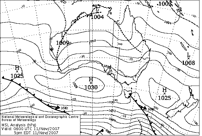
|
For notes on how to interpret
the data and quality control issues, see Daily Weather Summary Help.
**S** and **W** precede data flagged by the Bureau as suspicious or wrong
Data is as received at 01:32EST, 15/05/2012.
|
|
| |
Max
°
C |
+/- norm
°
C |
Min
°
C |
+/- norm
°
C |
Grass Min
°
C |
Rain to 9am mm |
Evaporation to 9am mm |
Sunshine hours |
Wind Run to 9am km (24-hour average km/h) |
Maximum Gust km/h / hour of occurrence |
| GERALDTON AIRPORT |
42.6 |
+15.5 |
15.9 |
+2.1 |
13.1 |
0.0 |
10.0 |
-- |
538 (22.4) |
50/08 |
| PERTH AIRPORT |
36.5 |
+10.7 |
17.7 |
+5.1 |
16.3 |
0.0 |
10.6 |
13.0 |
595 (24.8) |
59/23 |
| ALBANY AIRPORT |
22.6 |
+1.8 |
10.5 |
-0.3 |
7.5 |
0.0 |
5.8 |
12.6 |
415 (17.3) |
41/14 |
| BUNBURY |
33.4 |
+9.2 |
13.2 |
+1.2 |
-- |
0.0 |
-- |
-- |
342 (14.3) |
35/23 |
| MANDURAH |
36.2 |
-- |
17.3 |
-- |
-- |
0.0 |
-- |
-- |
353 (14.7) |
37/23 |
| DARWIN AIRPORT |
33.5 |
+0.2 |
25.5 |
+0.2 |
24.9 |
1.4 |
7.4 |
8.5 |
264 (11.0) |
34/16 |
| ALICE SPRINGS AIRPORT |
31.7 |
-1.9 |
18.0 |
+0.1 |
15.5 |
0.0 |
12.4 |
12.7 |
351 (14.6) |
48/10 |
| WHYALLA AERO |
28.3 |
+1.8 |
12.7 |
-1.2 |
-- |
0.0 |
24.0 |
-- |
294 (12.3) |
55/17 |
| ADELAIDE (KENT TOWN) |
30.4 |
+5.3 |
12.7 |
-1.3 |
8.5 |
0.0 |
-- |
13.2 |
201 ( 8.4) |
52/21 |
| MOUNT GAMBIER AERO |
23.9 |
+3.5 |
6.1 |
-2.3 |
3.0 |
0.0 |
5.2 |
13.1 |
206 ( 8.6) |
34/14 |
| MOUNT ISA AERO |
38.7 |
+2.3 |
24.5 |
+3.1 |
22.0 |
0.0 |
15.0 |
12.1 |
443 (18.5) |
41/15 |
| CAIRNS AERO |
31.3 |
+0.7 |
25.4 |
+3.1 |
23.1 |
4.4 |
13.8 |
7.4 |
356 (14.8) |
35/11 |
| TOWNSVILLE AERO |
31.9 |
+1.1 |
25.2 |
+2.3 |
24.4 |
0.0 |
9.4 |
11.7 |
584 (24.3) |
50/22 |
| MACKAY M.O |
27.7 |
-1.5 |
24.0 |
+2.3 |
-- |
0.6 |
-- |
10.8 |
400 (16.7) |
48/21 |
| ROCKHAMPTON AERO |
29.3 |
-1.9 |
21.3 |
+1.8 |
20.5 |
0.0 |
6.4 |
-- |
328 (13.7) |
41/17 |
| BUNDABERG AERO |
28.3 |
0.0 |
19.8 |
+0.9 |
-- |
0.0 |
7.0 |
-- |
477 (19.9) |
54/10 |
| NAMBOUR DPI |
25.1 |
-2.9 |
18.6 |
+2.3 |
-- |
5.4 |
-- |
-- |
162 ( 6.8) |
35/10 |
| COOLANGATTA |
23.8 |
-2.0 |
17.9 |
-0.3 |
-- |
11.8 |
-- |
-- |
391 (16.3) |
41/13 |
| BRISBANE AERO |
24.1 |
-2.7 |
18.4 |
+0.4 |
17.3 |
2.4 |
5.6 |
3.1 |
417 (17.4) |
41/13 |
| TOOWOOMBA AIRPORT |
23.2 |
-2.5 |
13.9 |
-0.6 |
-- |
0.0 |
-- |
-- |
737 (30.7) |
58/09 |
| GUNNEDAH RESOURCE CENTRE |
-- |
-- |
13.6 |
-1.4 |
10.8 |
0.0 |
7.2 |
-- |
317 (13.2) |
-- |
| COFFS HARBOUR MO |
22.7 |
-2.2 |
15.1 |
-1.0 |
13.5 |
5.2 |
2.8 |
8.9 |
441 (18.4) |
32/09 |
| PORT MACQUARIE AIRPORT AWS |
22.6 |
-2.3 |
15.1 |
+0.1 |
-- |
6.0 |
-- |
-- |
-- |
-- |
| WILLIAMTOWN RAAF |
23.2 |
-2.2 |
10.2 |
-4.1 |
8.9 |
2.0 |
5.0 |
10.9 |
236 ( 9.8) |
34/14 |
| GOSFORD (NARARA RESEARCH STATION) AWS |
23.5 |
-1.6 |
10.3 |
-2.8 |
-- |
1.0 |
-- |
-- |
70 ( 2.9) |
22/13 |
| ORANGE AGRICULTURAL INSTITUTE |
22.0 |
+0.9 |
7.0 |
-2.1 |
3.6 |
0.0 |
5.6 |
12.5 |
-- |
-- |
| DUBBO AIRPORT AWS |
28.0 |
-0.4 |
12.1 |
-1.5 |
-- |
0.0 |
-- |
-- |
-- |
-- |
| SYDNEY AIRPORT AMO |
23.5 |
-0.5 |
14.8 |
-0.5 |
10.7 |
0.0 |
4.8 |
12.8 |
-- |
39/15 |
| RICHMOND RAAF |
25.5 |
-1.1 |
11.2 |
-2.7 |
-- |
0.2 |
-- |
-- |
94 ( 3.9) |
31/16 |
| BELLAMBI AWS |
21.8 |
-0.3 |
13.7 |
-1.9 |
-- |
0.4 |
-- |
-- |
185 ( 7.7) |
30/17 |
| CANBERRA AIRPORT |
25.2 |
+2.5 |
9.1 |
+0.3 |
6.7 |
0.0 |
4.2 |
11.9 |
177 ( 7.4) |
30/16 |
| WAGGA WAGGA AMO |
29.5 |
+3.8 |
10.5 |
-0.2 |
9.4 |
0.0 |
8.2 |
13.4 |
242 (10.1) |
32/12 |
| ALBURY AIRPORT AWS |
28.3 |
+2.3 |
11.2 |
-0.4 |
-- |
0.0 |
-- |
-- |
141 ( 5.9) |
28/13 |
| MILDURA AIRPORT |
32.8 |
+5.4 |
13.4 |
+0.9 |
11.1 |
0.0 |
9.2 |
11.7 |
190 ( 7.9) |
41/11 |
| TATURA INST SUSTAINABLE AG |
29.9 |
+5.3 |
10.7 |
+0.6 |
-- |
0.8 |
-- |
-- |
287 (12.0) |
31/17 |
| BENDIGO AIRPORT |
29.9 |
+5.7 |
11.1 |
+1.6 |
-- |
0.0 |
-- |
-- |
310 (12.9) |
�
39/18 |
| MELBOURNE REGIONAL OFFICE |
25.9 |
+4.0 |
12.3 |
+1.1 |
8.9 |
0.0 |
5.0 |
-- |
133 ( 5.5) |
15/09 |
| GEELONG AIRPORT |
22.4 |
+1.4 |
7.2 |
-2.4 |
-- |
0.0 |
-- |
-- |
208 ( 8.7) |
35/15 |
| BALLARAT AERODROME |
24.9 |
+5.3 |
4.5 |
-3.3 |
-- |
0.0 |
-- |
-- |
278 (11.6) |
32/16 |
| LAUNCESTON (TI TREE BEND) |
22.4 |
+2.0 |
11.1 |
+2.2 |
-- |
0.0 |
-- |
-- |
195 ( 8.1) |
44/14 |
| HOBART AIRPORT |
24.8 |
+5.8 |
11.6 |
+2.4 |
8.5 |
0.0 |
7.2 |
10.6 |
318 (13.3) |
52/13 |
| |
Max
°
C |
+/- norm
°
C |
Min
°
C |
+/- norm
°
C |
Grass Min
°
C |
Rain to 9am mm |
Evaporation to 9am mm |
Sunshine hours |
Wind Run to 9am km |
Maximum Gust km/h / hour of occurrence |
|
| Hottest |
| Highest maximum temperature> | Greatest variation above normal maximum |
Highest minimum temperature | Greatest variation above normal minimum |
43.2 WEST ROEBUCK W Kimberley WA
43.0 WYNDHAM AERO N Kimberley WA
43.0 TOORAK RESEARCH STATION Gulf Country QLD
42.9 MCARTHUR RIVER MINE N Rivers NT
42.7 ENEABBA Central West WA
|
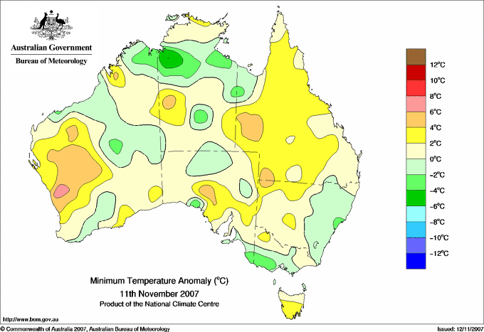
+15.6 : 40.3 LANCELIN Lower West WA
+15.5 : 42.6 GERALDTON AIRPORT Central West WA
+14.8 : 40.5 JURIEN BAY Lower West WA
+13.0 : 42.7 ENEABBA Central West WA
+12.5 : 40.5 KALBARRI Central West WA
|
30.4 WARRUWI N Rivers NT
29.1 DERBY AERO W Kimberley WA
28.5 MCCLUER ISLAND N Rivers NT
28.0 FITZROY CROSSING AERO W Kimberley WA
28.0 TROUGHTON ISLAND N Kimberley WA
|
+9.3 : 23.6 MULLEWA Central West WA
+7.8 : 20.0 BADGINGARRA RESEARCH STN Lower West WA
+7.2 : 21.3 MORAWA AIRPORT Central West WA
+7.1 : 20.4 CARNAMAH Central West WA
+7.0 : 18.8 GINGIN AERO Lower West WA
|
| Coldest |
| Lowest maximum temperature | Greatest variation below normal maximum |
Lowest minimum temperature | Greatest variation below normal minimum |
13.3 MAATSUYKER ISLAND LIGHTHOUSE Southeast TAS
13.5 MOUNT READ W Coast TAS
14.0 MT HOTHAM Upper NE VIC
14.5 THREDBO AWS Snowy Mtns NSW
|
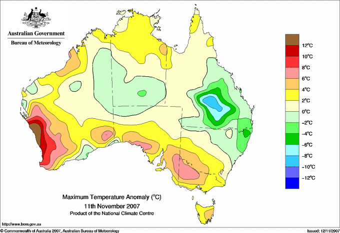
-9.3 : 24.0 TAMBO POST OFFICE Central Highlands QLD
-7.7 : 28.0 ISISFORD POST OFFICE Central West QLD
-7.6 : 23.9 INJUNE POST OFFICE Maranoa QLD
-7.3 : 24.6 MITCHELL POST OFFICE Maranoa QLD
-6.9 : 18.3 TABULAM (MUIRNE) N Tablelands E NSW
|
1.0 THREDBO VILLAGE Snowy Mtns NSW
1.9 MT HOTHAM AIRPORT Upper NE VIC
2.7 THREDBO AWS Snowy Mtns NSW
3.1 MORTLAKE RACECOURSE W Coast VIC
|
-6.4 : 18.9 TIMBER CREEK N Rivers NT
-5.5 : 6.4 QUIRINDI POST OFFICE NW Slopes S NSW
-5.3 : 3.6 WARRNAMBOOL AIRPORT NDB W Coast VIC
-5.1 : 19.5 VICTORIA RIVER DOWNS N Rivers NT
|
|
Sunniest &
dullest |
Windiest |
Highest gusts |
Todays highest rainfall totals for the 24 hours to 9am. It
includes the top 5 totals nationally followed by all reported falls of 50mm or more. |
Highest
and lowest recordings of hours of sunshine for the 24 hours to midnight. |
Highest wind
run totals in kilometres for the 24 hours to 9am (average speed in brackets).
All reported runs >
=25km/h are shown. |
Highest wind
gusts in km/h for the 24 hours to midnight followed by the hour in which it occurred.
All stations with gusts >
89km/h are shown. |
85.0 MARENGO Central West QLD
66.0 BRUNSWICK HEADS BOWLING CLUB North Coast NSW
65.0 WAHROONGHA Central West QLD
52.4 HARWOOD ISLAND (HARWOOD SUGAR MILL) North Coast NSW
49.6 GULMARRAD (COLONIAL DRIVE) North Coast NSW
QUEENSLAND
Central West
85.0 MARENGO
65.0 WAHROONGHA
NEW SOUTH WALES
North Coast
66.0 BRUNSWICK HEADS BOWLING CLUB
52.4 HARWOOD ISLAND (HARWOOD SUGAR MILL)
49.6 GULMARRAD (COLONIAL DRIVE)
|
13.6 ADELAIDE AIRPORT Adelaide/Lofty SA
13.4 WAGGA WAGGA AMO SW Slopes S NSW
13.4 MELBOURNE AIRPORT E Central VIC
13.3 CEDUNA AMO W Agricultural SA
13.2 ADELAIDE (KENT TOWN) Adelaide/Lofty SA
13.2 NURIOOTPA VITICULTURAL Adelaide/Lofty SA
13.2 COBAR MO Upper Darling NSW
13.2 EAST SALE AIRPORT W Gippsland VIC
.....
5.5 STRATHGORDON VILLAGE W Coast TAS
4.5 BRIAN PASTURES Brisbane/SE Coast QLD
3.1 BRISBANE AERO Brisbane/SE Coast QLD
1.2 ALSTONVILLE TROPICAL FRUIT RESEARCH STAT North Coast NSW
0.5 NORFOLK ISLAND AERO Islands ISL
|
1089 (45.4) DOUBLE ISLAND POINT LIGHTHOUSE Brisbane/SE Coast QLD
1056 (44.0) CAPE MORETON LIGHTHOUSE Brisbane/SE Coast QLD
812 (33.8) BYRON BAY (CAPE BYRON AWS) North Coast NSW
777 (32.4) RUNDLE ISLAND Wide Bay/Burnett QLD
738 (30.8) WILLIS ISLAND Islands ISL
737 (30.7) TOOWOOMBA AIRPORT Darling Downs E QLD
736 (30.7) NORTH ISLAND Central West WA
731 (30.5) CAPE LEEUWIN Lower West WA
726 (30.3) LORD HOWE ISLAND AERO Islands ISL
671 (28.0) YAMBA PILOT STATION North Coast NSW
670 (27.9) CARNARVON AIRPORT W Gascoyne WA
662 (27.6) HERON ISLAND RES STN Wide Bay/Burnett QLD
641 (26.7) PEARCE RAAF Lower West WA
635 (26.5) MURRURUNDI GAP AWS Hunter Valley NSW
634 (26.4) LADY ELLIOT ISLAND Wide Bay/Burnett QLD
633 (26.4) ROTTNEST ISLAND Lower West WA
622 (25.9) MAROOCHYDORE AERO Brisbane/SE Coast QLD
607 (25.3) NORFOLK ISLAND AERO Islands ISL
604 (25.2) CAPE FLATTERY N Coast--Barron QLD
602 (25.1) GABO ISLAND LIGHTHOUSE E Gippsland VIC
601 (25.0) MAATSUYKER ISLAND LIGHTHOUSE Southeast TAS
|
72/18 DUM IN MIRRIE AWS N Rivers NT
72/16 WINTON AIRPORT Northwest QLD
72/06 MOUNT WELLINGTON Southeast TAS
70/16 MIDDLE POINT AWS N Rivers NT
70/20 RICHMOND AIRPORT Upper Carpentaria QLD
70/19 RUNDLE ISLAND Wide Bay/Burnett QLD
|
�