|
For notes on how to interpret
the data and quality control issues, see Daily Weather Summary Help.
**S** and **W** precede data flagged by the Bureau as suspicious or wrong
Data is as received at 01:02EST, 15/05/2012.
|
|
| |
Max
°
C |
+/- norm
°
C |
Min
°
C |
+/- norm
°
C |
Grass Min
°
C |
Rain to 9am mm |
Evaporation to 9am mm |
Sunshine hours |
Wind Run to 9am km (24-hour average km/h) |
Maximum Gust km/h / hour of occurrence |
| GERALDTON AIRPORT |
17.5 |
-2.5 |
9.2 |
+0.3 |
7.5 |
11.4 |
5.2 |
-- |
424 (17.7) |
32/12 |
| PERTH AIRPORT |
16.6 |
-1.8 |
4.4 |
-3.6 |
3.7 |
10.2 |
1.4 |
6.8 |
287 (12.0) |
28/12 |
| ALBANY AIRPORT |
14.2 |
-1.9 |
6.7 |
-0.8 |
4.8 |
3.2 |
0.6 |
5.0 |
341 (14.2) |
34/10 |
| BUNBURY |
15.2 |
-2.1 |
2.7 |
-4.9 |
-- |
0.0 |
-- |
-- |
197 ( 8.2) |
24/15 |
| MANDURAH |
16.3 |
-- |
7.4 |
-- |
-- |
3.2 |
-- |
-- |
310 (12.9) |
26/15 |
| DARWIN AIRPORT |
29.0 |
-2.3 |
18.9 |
-1.5 |
18.0 |
0.0 |
4.2 |
9.5 |
247 (10.3) |
43/14 |
| ALICE SPRINGS AIRPORT |
30.1 |
+7.5 |
16.7 |
+10.7 |
10.8 |
0.0 |
8.6 |
10.0 |
431 (18.0) |
55/18 |
| WHYALLA AERO |
17.3 |
-1.2 |
3.4 |
-2.5 |
-- |
0.0 |
4.4 |
-- |
350 (14.6) |
30/15 |
| ADELAIDE (KENT TOWN) |
16.4 |
-0.3 |
10.2 |
+2.0 |
6.6 |
1.0 |
3.0 |
1.7 |
346 (14.4) |
35/11 |
| MOUNT GAMBIER AERO |
13.8 |
-0.3 |
9.5 |
+4.0 |
8.9 |
21.4 |
4.0 |
6.8 |
573 (23.9) |
71/13 |
| MOUNT ISA AERO |
29.1 |
+1.8 |
6.8 |
-3.5 |
5.0 |
0.0 |
5.4 |
10.8 |
156 ( 6.5) |
32/13 |
| CAIRNS AERO |
26.2 |
-0.4 |
19.7 |
+2.3 |
16.8 |
0.0 |
4.4 |
3.5 |
404 (16.8) |
39/11 |
| TOWNSVILLE AERO |
27.5 |
+1.5 |
17.7 |
+3.0 |
17.2 |
0.0 |
4.6 |
7.3 |
336 (14.0) |
39/14 |
| MACKAY M.O |
22.4 |
-0.1 |
13.7 |
-0.3 |
-- |
0.2 |
-- |
10.3 |
279 (11.6) |
22/14 |
| ROCKHAMPTON AERO |
26.2 |
+1.4 |
10.2 |
-0.4 |
8.7 |
0.0 |
3.0 |
-- |
159 ( 6.6) |
32/17 |
| BUNDABERG AERO |
25.0 |
+1.7 |
9.5 |
-1.4 |
-- |
0.0 |
3.8 |
-- |
195 ( 8.1) |
31/11 |
| NAMBOUR DPI |
26.8 |
+4.3 |
11.2 |
+3.2 |
-- |
0.0 |
1.4 |
-- |
-- |
24/15 |
| COOLANGATTA |
26.7 |
+5.4 |
11.4 |
+1.0 |
-- |
0.0 |
-- |
-- |
274 (11.4) |
41/16 |
| BRISBANE AERO |
22.9 |
+1.1 |
7.6 |
-2.0 |
3.7 |
0.0 |
2.6 |
9.9 |
322 (13.4) |
37/14 |
| TOOWOOMBA AIRPORT |
23.2 |
+4.5 |
11.0 |
+3.5 |
-- |
0.0 |
-- |
-- |
440 (18.3) |
37/11 |
| GUNNEDAH RESOURCE CENTRE |
23.7 |
+5.8 |
11.3 |
+5.5 |
5.2 |
0.0 |
4.0 |
-- |
140 ( 5.8) |
-- |
| COFFS HARBOUR MO |
24.2 |
+4.4 |
10.1 |
+1.9 |
5.1 |
0.0 |
1.4 |
1.3 |
375 (15.6) |
32/14 |
| PORT MACQUARIE AIRPORT AWS |
19.4 |
-0.8 |
7.8 |
+1.1 |
-- |
0.0 |
-- |
-- |
-- |
-- |
| WILLIAMTOWN RAAF |
26.0 |
+7.4 |
10.1 |
+3.3 |
9.1 |
0.0 |
4.8 |
5.0 |
286 (11.9) |
54/20 |
| GOSFORD (NARARA RESEARCH STATION) AWS |
24.8 |
+5.8 |
8.0 |
+2.7 |
-- |
0.0 |
-- |
-- |
77 ( 3.2) |
21/16 |
| ORANGE AGRICULTURAL INSTITUTE |
12.8 |
+1.8 |
6.1 |
+4.0 |
3.1 |
4.6 |
2.6 |
0.0 |
-- |
-- |
| DUBBO AIRPORT AWS |
18.2 |
+0.7 |
10.5 |
+7.1 |
-- |
0.0 |
-- |
-- |
-- |
-- |
| SYDNEY AIRPORT AMO |
21.7 |
+3.4 |
11.9 |
+3.8 |
6.5 |
0.0 |
6.8 |
5.2 |
402 (16.8) |
39/22 |
| RICHMOND RAAF |
24.8 |
+5.0 |
12.9 |
+8.5 |
-- |
0.0 |
-- |
-- |
315 (13.1) |
35/16 |
| BELLAMBI AWS |
18.7 |
+0.7 |
10.2 |
-0.3 |
-- |
0.0 |
-- |
-- |
195 ( 8.1) |
39/21 |
| CANBERRA AIRPORT |
16.3 |
+3.3 |
4.7 |
+3.7 |
0.8 |
0.0 |
1.8 |
8.1 |
478 (19.9) |
50/13 |
| WAGGA WAGGA AMO |
16.9 |
+2.4 |
1.9 |
-1.7 |
0.1 |
0.0 |
0.8 |
7.7 |
200 ( 8.3) |
24/13 |
| ALBURY AIRPORT AWS |
17.7 |
+2.7 |
3.4 |
-0.4 |
-- |
0.0 |
-- |
-- |
156 ( 6.5) |
44/15 |
| MILDURA AIRPORT |
18.6 |
+1.4 |
5.4 |
+0.2 |
0.6 |
0.0 |
3.2 |
4.9 |
276 (11.5) |
48/13 |
| TATURA INST SUSTAINABLE AG |
16.6 |
+1.9 |
6.1 |
+2.2 |
-- |
0.0 |
2.6 |
-- |
243 (10.1) |
46/12 |
| BENDIGO AIRPORT |
13.3 |
-1.0 |
4.1 |
+1.6 |
-- |
0.0 |
-- |
-- |
330 (13.8) |
�
44/12 |
| MELBOURNE REGIONAL OFFICE |
16.2 |
+1.2 |
10.4 |
+3.7 |
8.6 |
0.0 |
2.6 |
-- |
221 ( 9.2) |
35/12 |
| GEELONG AIRPORT |
14.9 |
-0.1 |
10.7 |
+4.8 |
-- |
0.0 |
-- |
-- |
697 (29.0) |
67/10 |
| BALLARAT AERODROME |
11.9 |
+0.5 |
5.4 |
+1.7 |
-- |
0.2 |
-- |
-- |
658 (27.4) |
52/13 |
| LAUNCESTON (TI TREE BEND) |
10.7 |
-3.0 |
8.3 |
+4.7 |
-- |
44.8 |
-- |
-- |
344 (14.3) |
41/01 |
| HOBART AIRPORT |
11.7 |
-1.8 |
7.3 |
+2.6 |
7.7 |
0.8 |
3.6 |
2.5 |
469 (19.5) |
43/15 |
| |
Max
°
C |
+/- norm
°
C |
Min
°
C |
+/- norm
°
C |
Grass Min
°
C |
Rain to 9am mm |
Evaporation to 9am mm |
Sunshine hours |
Wind Run to 9am km |
Maximum Gust km/h / hour of occurrence |
|
| Hottest |
| Highest maximum temperature> | Greatest variation above normal maximum |
Highest minimum temperature | Greatest variation above normal minimum |
33.9 WYNDHAM AERO N Kimberley WA
33.5 WYNDHAM N Kimberley WA
33.2 BIRDSVILLE AIRPORT Channel Country QLD
33.2 TIMBER CREEK N Rivers NT
33.2 BRADSHAW N Rivers NT
|
+8.4 : 33.2 BIRDSVILLE AIRPORT Channel Country QLD
+8.2 : 29.4 EVANS HEAD RAAF BOMBING RANGE AWS North Coast NSW
+8.2 : 29.2 MUNGINDI POST OFFICE NW Plains W NSW
+7.8 : 29.2 BOLLON MARY ST Warrego QLD
+7.7 : 27.1 PATERSON (TOCAL AWS) Hunter Valley NSW
|
25.0 NORTHERN ENDEAVOUR Islands ISL
23.9 COCOS ISLAND AIRPORT Islands ISL
23.6 MCCLUER ISLAND N Rivers NT
23.0 TROUGHTON ISLAND N Kimberley WA
22.9 CHRISTMAS ISLAND AERO Islands ISL
|
+10.7 : 16.7 ALICE SPRINGS AIRPORT N Plateau NT
+8.6 : 11.6 DUNEDOO POST OFFICE CW Slopes N NSW
+8.5 : 12.9 RICHMOND RAAF Sydney--west NSW
+8.4 : 15.3 CASINO AIRPORT AWS North Coast NSW
+8.3 : 15.4 JERVOIS N Plateau NT
|
| Coldest |
| Lowest maximum temperature | Greatest variation below normal maximum |
Lowest minimum temperature | Greatest variation below normal minimum |
-0.3 MT HOTHAM Upper NE VIC
0.1 THREDBO AWS Snowy Mtns NSW
1.0 MOUNT WELLINGTON Southeast TAS
1.3 MOUNT BULLER Upper NE VIC
1.3 FALLS CREEK Upper NE VIC
|
-7.2 : 13.7 ERNABELLA (PUKATJA) NW Pastoral SA
-6.1 : 19.5 TOM PRICE W Pilbara WA
-5.5 : 18.2 YULARA AERO N Plateau NT
-5.4 : 21.8 PARABURDOO AERO E Gascoyne WA
-4.8 : 16.1 MOUNT MAGNET AERO E Gascoyne WA
-4.8 : 17.0 WILUNA Interior WA
|
-2.5 COOMA VISITORS CENTRE Goulburn/Monaro NSW
-1.7 THREDBO AWS Snowy Mtns NSW
-1.5 BOMBALA (THERRY STREET) Goulburn/Monaro NSW
-1.5 MT HOTHAM Upper NE VIC
-0.7 FALLS CREEK Upper NE VIC
|
-5.3 : -0.1 JARRAHWOOD Lower West WA
-4.9 : 2.7 BUNBURY Lower West WA
-4.5 : 14.6 GOVE AIRPORT N Rivers NT
-4.5 : 1.6 DONNYBROOK Lower West WA
-4.4 : 2.3 UNIVERSITY OF QUEENSLAND GATTON Brisbane/SE Coast QLD
|
|
Sunniest &
dullest |
Windiest |
Highest gusts |
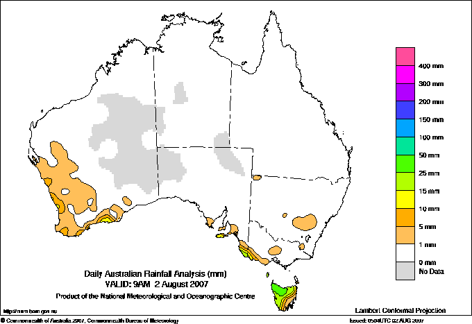
Todays highest rainfall totals for the 24 hours to 9am. It
includes the top 5 totals nationally followed by all reported falls of 50mm or more. |
Highest
and lowest recordings of hours of sunshine for the 24 hours to midnight. |
Highest wind
run totals in kilometres for the 24 hours to 9am (average speed in brackets).
All reported runs >
=25km/h are shown. |
Highest wind
gusts in km/h for the 24 hours to midnight followed by the hour in which it occurred.
All stations with gusts >
89km/h are shown. |
54.0 LOONGANA (SERENDIPITY) N Coast TAS
52.6 ERRIBA (JUBB ROAD) N Coast TAS
47.6 CRADLE VALLEY (WALDHEIM) Central Plateau TAS
46.2 DERWENT BRIDGE (DERWENT RIVER) Central Plateau TAS
44.8 LAUNCESTON (TI TREE BEND) N Coast TAS
TASMANIA
N Coast
54.0 LOONGANA (SERENDIPITY)
52.6 ERRIBA (JUBB ROAD)
44.8 LAUNCESTON (TI TREE BEND)
Central Plateau
47.6 CRADLE VALLEY (WALDHEIM)
46.2 DERWENT BRIDGE (DERWENT RIVER)
|
10.8 MOUNT ISA AERO Gulf Country QLD
10.7 BROOME AIRPORT W Kimberley WA
10.7 TENNANT CREEK AIRPORT N Plateau NT
10.3 WEIPA AERO N Peninsula QLD
10.3 MACKAY M.O Central Coast E QLD
.....
0.5 COWRA RESEARCH CENTRE (EVANS ST) C Tablelands S NSW
0.3 STRATHGORDON VILLAGE W Coast TAS
0.0 WOOMERA AERODROME NW Pastoral SA
0.0 ORANGE AGRICULTURAL INSTITUTE C Tablelands S NSW
0.0 SCOTTSDALE (WEST MINSTONE ROAD) N Coast TAS
|
1394 (58.1) THREDBO AWS Snowy Mtns NSW
1252 (52.2) NEPTUNE ISLAND W Agricultural SA
1210 (50.4) MOUNT WELLINGTON Southeast TAS
1089 (45.4) COLAC (MT GELLIBRAND) W Coast VIC
1042 (43.4) MAATSUYKER ISLAND LIGHTHOUSE Southeast TAS
1026 (42.8) AIREYS INLET W Coast VIC
1020 (42.5) FALLS CREEK Upper NE VIC
1017 (42.4) VARANUS ISLAND Islands ISL
1009 (42.0) HOGAN ISLAND Islands ISL
995 (41.5) SWAN ISLAND E Coast TAS
987 (41.1) MOUNT BULLER Upper NE VIC
980 (40.8) SCOTTS PEAK DAM W Coast TAS
943 (39.3) KING ISLAND AIRPORT King Island TAS
923 (38.5) BARROW ISLAND AIRPORT W Pilbara WA
906 (37.8) CAPE WILLOUGHBY Yorke Pen/Kanga Is SA
875 (36.5) CAPE GRIM BAPS N Coast TAS
845 (35.2) WALLAN (KILMORE GAP) N Central VIC
839 (35.0) MOUNT READ W Coast TAS
836 (34.8) HINDMARSH ISLAND AWS Adelaide/Lofty SA
836 (34.8) RHYLL E Central VIC
832 (34.7) LOW HEAD N Coast TAS
807 (33.6) THEVENARD ISLAND W Pilbara WA
801 (33.4) EDDYSTONE POINT E Coast TAS
788 (32.8) FERNY CREEK (DUNNS HILL) E Central VIC
783 (32.6) MOUNT BOYCE AWS C Tablelands S NSW
782 (32.6) CAPE JAFFA (CURLEY HILLS) Lower SE SA
779 (32.5) STRATHALBYN RACECOURSE Murray Valley SA
771 (32.1) CAPE LEEUWIN Lower West WA
769 (32.0) NORTH SHIELDS (PORT LINCOLN AWS) W Agricultural SA
768 (32.0) COULTA (COLES POINT) W Agricultural SA
748 (31.2) LOW ISLES LIGHTHOUSE N Coast--Barron QLD
746 (31.1) DINNER PLAIN (MT HOTHAM AIRPORT) Upper NE VIC
736 (30.7) FLINDERS ISLAND AIRPORT Flinders Is/Bass St TAS
731 (30.5) STENHOUSE BAY Yorke Pen/Kanga Is SA
729 (30.4) EDITHBURGH Yorke Pen/Kanga Is SA
724 (30.2) NORTH ISLAND Central West WA
724 (30.2) MURRURUNDI GAP AWS Hunter Valley NSW
721 (30.0) ROBE AIRFIELD Lower SE SA
716 (29.8) WARRNAMBOOL AIRPORT NDB W Coast VIC
713 (29.7) WILLIS ISLAND Islands ISL
704 (29.3) CAPE MORETON LIGHTHOUSE Brisbane/SE Coast QLD
699 (29.1) MOORABBIN AIRPORT E Central VIC
697 (29.0) GEELONG AIRPORT W Central VIC
691 (28.8) CLEVE AERODROME W Agricultural SA
687 (28.6) DEVONPORT AIRPORT N Coast TAS
684 (28.5) CAPE NELSON LIGHTHOUSE W Coast VIC
672 (28.0) CAPE OTWAY LIGHTHOUSE W Coast VIC
665 (27.7) MELBOURNE AIRPORT E Central VIC
662 (27.6) MORTLAKE RACECOURSE W Coast VIC
658 (27.4) BALLARAT AERODROME Western Plains VIC
652 (27.2) MOUNT CRAWFORD FIRE TOWER Adelaide/Lofty SA
646 (26.9) PORTLAND (CASHMORE AIRPORT) W Coast VIC
641 (26.7) ROTTNEST ISLAND Lower West WA
640 (26.7) GOULBURN AIRPORT AWS Goulburn/Monaro NSW
637 (26.5) COCOS ISLAND AIRPORT Islands ISL
634 (26.4) HAMILTON AIRPORT W Coast VIC
632 (26.3) AVALON AIRPORT W Central VIC
627 (26.1) COONAWARRA Lower SE SA
627 (26.1) WILSONS PROMONTORY LIGHTHOUSE W Gippsland VIC
618 (25.8) STRAHAN AERODROME W Coast TAS
612 (25.5) TASMAN ISLAND Southeast TAS
611 (25.5) SHEOAKS W Central VIC
609 (25.4) CAPE NATURALISTE Lower West WA
608 (25.3) MINLATON AERO Yorke Pen/Kanga Is SA
|
113/01 CAPE GRIM BAPS N Coast TAS
111/19 HOGAN ISLAND Islands ISL
104/19 WILSONS PROMONTORY LIGHTHOUSE W Gippsland VIC
100/00 AIREYS INLET W Coast VIC
98/22 MAATSUYKER ISLAND LIGHTHOUSE Southeast TAS
96/05 MOUNT WELLINGTON Southeast TAS
94/14 SWAN ISLAND E Coast TAS
93/17 THREDBO AWS Snowy Mtns NSW
91/01 NEPTUNE ISLAND W Agricultural SA
91/00 LOW HEAD N Coast TAS
91/01 EDDYSTONE POINT E Coast TAS
|
�