|
For notes on how to interpret
the data and quality control issues, see Daily Weather Summary Help.
**S** and **W** precede data flagged by the Bureau as suspicious or wrong
Data is as received at 01:45EST, 15/05/2012.
|
|
| |
Max
°
C |
+/- norm
°
C |
Min
°
C |
+/- norm
°
C |
Grass Min
°
C |
Rain to 9am mm |
Evaporation to 9am mm |
Sunshine hours |
Wind Run to 9am km (24-hour average km/h) |
Maximum Gust km/h / hour of occurrence |
| GERALDTON AIRPORT |
40.4 |
+10.9 |
19.2 |
+2.9 |
15.3 |
0.0 |
18.8 |
-- |
706 (29.4) |
55/07 |
| PERTH AIRPORT |
35.7 |
+6.8 |
18.8 |
+4.0 |
17.2 |
0.0 |
13.6 |
13.4 |
652 (27.2) |
59/03 |
| ALBANY AIRPORT |
25.3 |
+2.2 |
14.3 |
+1.9 |
12.5 |
0.0 |
7.8 |
12.9 |
576 (24.0) |
45/14 |
| BUNBURY |
34.5 |
+7.4 |
16.5 |
+3.2 |
-- |
0.0 |
-- |
-- |
378 (15.8) |
44/06 |
| MANDURAH |
35.8 |
-- |
19.2 |
-- |
-- |
0.0 |
-- |
-- |
380 (15.8) |
41/05 |
| DARWIN AIRPORT |
32.9 |
+0.3 |
25.4 |
+0.1 |
25.1 |
0.0 |
5.0 |
4.5 |
304 (12.7) |
43/11 |
| ALICE SPRINGS AIRPORT |
29.2 |
-6.2 |
13.7 |
-6.5 |
11.6 |
0.0 |
12.0 |
12.9 |
409 (17.0) |
44/13 |
| WHYALLA AERO |
21.9 |
-6.2 |
16.3 |
+0.5 |
-- |
0.0 |
-- |
-- |
481 (20.0) |
54/17 |
| ADELAIDE (KENT TOWN) |
23.1 |
-3.9 |
14.6 |
-0.9 |
13.2 |
0.0 |
13.2 |
5.7 |
252 (10.5) |
43/16 |
| MOUNT GAMBIER AERO |
19.8 |
-3.1 |
11.3 |
+1.4 |
9.2 |
1.2 |
2.8 |
8.4 |
430 (17.9) |
43/12 |
| MOUNT ISA AERO |
31.7 |
-5.5 |
22.5 |
-0.6 |
21.0 |
0.0 |
9.0 |
3.3 |
387 (16.1) |
37/18 |
| CAIRNS AERO |
32.5 |
+1.1 |
24.7 |
+1.3 |
21.9 |
0.0 |
7.0 |
7.8 |
192 ( 8.0) |
28/12 |
| TOWNSVILLE AERO |
33.1 |
+1.6 |
27.4 |
+3.3 |
26.1 |
0.0 |
6.8 |
8.3 |
314 (13.1) |
39/12 |
| MACKAY M.O |
31.6 |
+1.5 |
22.8 |
-0.1 |
-- |
4.6 |
-- |
5.8 |
288 (12.0) |
34/21 |
| ROCKHAMPTON AERO |
26.4 |
-5.7 |
23.7 |
+2.5 |
24.0 |
22.4 |
6.0 |
-- |
203 ( 8.5) |
34/11 |
| BUNDABERG AERO |
24.0 |
-5.4 |
21.1 |
+0.6 |
-- |
5.4 |
3.4 |
-- |
383 (16.0) |
-- |
| NAMBOUR DPI |
24.0 |
-5.2 |
21.0 |
+2.8 |
-- |
8.0 |
-- |
-- |
-- |
-- |
| COOLANGATTA |
27.8 |
+0.6 |
20.0 |
+0.1 |
-- |
0.0 |
-- |
-- |
414 (17.3) |
43/13 |
| BRISBANE AERO |
27.1 |
-1.2 |
21.0 |
+0.9 |
19.5 |
5.6 |
4.0 |
6.2 |
398 (16.6) |
39/13 |
| TOOWOOMBA AIRPORT |
26.3 |
-1.4 |
15.8 |
-0.9 |
-- |
0.0 |
-- |
-- |
522 (21.8) |
37/14 |
| GUNNEDAH RESOURCE CENTRE |
27.9 |
-3.1 |
15.8 |
-1.7 |
13.8 |
0.0 |
7.0 |
-- |
189 ( 7.9) |
-- |
| COFFS HARBOUR MO |
24.9 |
-1.4 |
18.1 |
0.0 |
16.4 |
0.8 |
8.8 |
6.0 |
377 (15.7) |
32/09 |
| PORT MACQUARIE AIRPORT AWS |
24.7 |
-1.9 |
17.3 |
+0.6 |
-- |
0.0 |
-- |
-- |
-- |
-- |
| WILLIAMTOWN RAAF |
23.4 |
-3.8 |
16.4 |
-0.1 |
15.3 |
1.2 |
7.2 |
7.7 |
395 (16.5) |
30/14 |
| GOSFORD (NARARA RESEARCH STATION) AWS |
23.6 |
-3.3 |
15.6 |
+0.3 |
-- |
0.0 |
-- |
-- |
194 ( 8.1) |
18/11 |
| ORANGE AGRICULTURAL INSTITUTE |
19.5 |
-4.9 |
8.9 |
-2.4 |
6.3 |
0.0 |
3.2 |
13.0 |
-- |
-- |
| DUBBO AIRPORT AWS |
24.9 |
-6.6 |
12.2 |
-3.7 |
-- |
0.0 |
-- |
-- |
-- |
-- |
| SYDNEY AIRPORT AMO |
23.7 |
-2.0 |
16.0 |
-1.5 |
12.6 |
0.0 |
8.8 |
10.4 |
484 (20.2) |
37/15 |
| RICHMOND RAAF |
25.9 |
-2.8 |
16.2 |
+0.2 |
-- |
0.0 |
-- |
-- |
208 ( 8.7) |
35/16 |
| BELLAMBI AWS |
22.5 |
-1.6 |
15.3 |
-2.2 |
-- |
0.0 |
-- |
-- |
363 (15.1) |
31/21 |
| CANBERRA AIRPORT |
24.4 |
-1.7 |
12.4 |
+1.0 |
11.2 |
0.0 |
6.2 |
12.1 |
296 (12.3) |
45/12 |
| WAGGA WAGGA AMO |
24.9 |
-4.5 |
10.1 |
-3.6 |
8.6 |
0.0 |
8.0 |
13.8 |
266 (11.1) |
45/12 |
| ALBURY AIRPORT AWS |
24.4 |
-5.0 |
10.8 |
-2.9 |
-- |
0.0 |
-- |
-- |
209 ( 8.7) |
48/15 |
| MILDURA AIRPORT |
25.2 |
-4.9 |
12.0 |
-2.8 |
10.6 |
0.0 |
8.2 |
13.3 |
383 (16.0) |
45/11 |
| TATURA INST SUSTAINABLE AG |
-- |
-- |
10.2 |
-2.0 |
-- |
0.0 |
15.5 |
-- |
320 (13.3) |
-- |
| BENDIGO AIRPORT |
21.0 |
-6.0 |
11.7 |
+0.2 |
-- |
0.0 |
-- |
-- |
374 (15.6) |
�
46/13 |
| MELBOURNE REGIONAL OFFICE |
19.6 |
-4.6 |
14.1 |
+1.2 |
11.9 |
0.0 |
3.8 |
-- |
164 ( 6.8) |
24/10 |
| GEELONG AIRPORT |
18.3 |
-4.6 |
12.2 |
+1.3 |
-- |
2.6 |
-- |
-- |
404 (16.8) |
57/14 |
| BALLARAT AERODROME |
17.2 |
-5.4 |
9.3 |
-0.1 |
-- |
0.0 |
-- |
-- |
388 (16.2) |
48/09 |
| LAUNCESTON (TI TREE BEND) |
19.1 |
-3.3 |
12.3 |
+1.7 |
-- |
0.0 |
-- |
-- |
328 (13.7) |
48/14 |
| HOBART AIRPORT |
15.5 |
-5.1 |
10.1 |
-0.6 |
7.4 |
1.2 |
6.0 |
10.6 |
509 (21.2) |
63/10 |
| |
Max
°
C |
+/- norm
°
C |
Min
°
C |
+/- norm
°
C |
Grass Min
°
C |
Rain to 9am mm |
Evaporation to 9am mm |
Sunshine hours |
Wind Run to 9am km |
Maximum Gust km/h / hour of occurrence |
|
| Hottest |
| Highest maximum temperature> | Greatest variation above normal maximum |
Highest minimum temperature | Greatest variation above normal minimum |
43.3 MARBLE BAR E Pilbara WA
43.3 GASCOYNE JUNCTION W Gascoyne WA
43.2 ROEBOURNE AERO E Pilbara WA
43.1 PARABURDOO AERO E Gascoyne WA
43.0 EMU CREEK STATION W Gascoyne WA
|
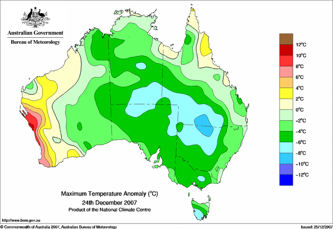
+10.9 : 40.4 GERALDTON AIRPORT Central West WA
+10.9 : 39.0 JURIEN BAY Lower West WA
+10.6 : 37.8 LANCELIN Lower West WA
+9.7 : 40.7 KALBARRI Central West WA
+9.1 : 33.9 ROTTNEST ISLAND Lower West WA
|
31.5 MARBLE BAR E Pilbara WA
30.2 WITTENOOM W Pilbara WA
28.9 BROOME AIRPORT W Kimberley WA
28.4 BURKETOWN POST OFFICE Gulf Country QLD
28.4 BURKETOWN AIRPORT Gulf Country QLD
28.4 TELFER AERO Interior WA
|
+7.0 : 22.5 JURIEN BAY Lower West WA
+6.7 : 26.0 SHARK BAY AIRPORT W Gascoyne WA
+6.5 : 22.5 CARNAMAH Central West WA
+6.2 : 23.6 KALBARRI Central West WA
+6.2 : 21.0 BADGINGARRA RESEARCH STN Lower West WA
+6.2 : 20.9 PEARCE RAAF Lower West WA
+6.2 : 20.2 GINGIN AERO Lower West WA
|
| Coldest |
| Lowest maximum temperature | Greatest variation below normal maximum |
Lowest minimum temperature | Greatest variation below normal minimum |
3.4 MOUNT READ W Coast TAS
3.5 MOUNT WELLINGTON Southeast TAS
4.9 HARTZ MOUNTAIN (KEOGHS PIMPLE) Southeast TAS
5.1 MT BAW BAW W Gippsland VIC
7.6 MOUNT BULLER Upper NE VIC
|
-9.9 : 4.9 HARTZ MOUNTAIN (KEOGHS PIMPLE) Southeast TAS
-9.2 : 5.1 MT BAW BAW W Gippsland VIC
-9.1 : 8.1 LAKE ST CLAIR NATIONAL PARK Central Plateau TAS
-9.0 : 26.0 WANAARING POST OFFICE Upper Darling NSW
-8.8 : 30.0 URANDANGI Northwest QLD
-8.8 : 9.0 TARRALEAH VILLAGE Derwent Valley TAS
|
-0.8 MOUNT WELLINGTON Southeast TAS
-0.1 MT HOTHAM Upper NE VIC
0.1 MOUNT BULLER Upper NE VIC
0.6 HARTZ MOUNTAIN (KEOGHS PIMPLE) Southeast TAS
0.7 MT BAW BAW W Gippsland VIC
0.7 MOUNT READ W Coast TAS
|
**W** -7.8 : 6.4 POINT HICKS (LIGHTHOUSE) E Gippsland VIC
-6.9 : 13.8 CUNNAMULLA POST OFFICE Warrego QLD
-6.6 : 15.0 TIBOOBURRA AIRPORT Far Northwest NSW
-6.5 : 13.7 ALICE SPRINGS AIRPORT N Plateau NT
-6.4 : 14.0 CHARLEVILLE AERO Warrego QLD
|
|
Sunniest &
dullest |
Windiest |
Highest gusts |
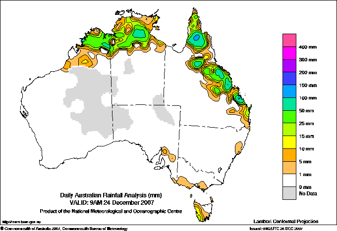
Todays highest rainfall totals for the 24 hours to 9am. It
includes the top 5 totals nationally followed by all reported falls of 50mm or more. |
Highest
and lowest recordings of hours of sunshine for the 24 hours to midnight. |
Highest wind
run totals in kilometres for the 24 hours to 9am (average speed in brackets).
All reported runs >
=25km/h are shown. |
Highest wind
gusts in km/h for the 24 hours to midnight followed by the hour in which it occurred.
All stations with gusts >
89km/h are shown. |
159.2 HAZELDEAN Wide Bay/Burnett QLD
153.0 CALLIOPE STATION Wide Bay/Burnett QLD
125.2 RAVENSWOOD POST OFFICE Central Coast E QLD
124.0 MOONMERA Wide Bay/Burnett QLD
118.0 RAGLAN Wide Bay/Burnett QLD
WESTERN AUSTRALIA
N Kimberley
89.0 HOME VALLEY
68.4 EL QUESTRO
57.0 DIGGERS REST
55.2 KURI BAY
E Kimberley
83.4 ARGYLE AERODROME
64.0 CARLTON HILL
NORTHERN TERRITORY
N Rivers
79.4 COODARDIE
63.0 MATARANKA HOMESTEAD RESORT
58.0 HODGSON RIVER
QUEENSLAND
N Peninsula
102.5 STRATHMAY STATION
67.8 BALURGA STATION
59.0 HEATHLANDS NATIONAL PARK
S Peninsula
61.8 PALMERVILLE
Gulf Country
84.0 DUNBAR STATION
Upper Carpentaria
65.0 GILBERTON
54.0 CLARKE HILLS STATION
N Coast--Herbert
89.4 CAMEL CREEK STATION
54.0 ROLLINGSTONE
Central Coast E
125.2 RAVENSWOOD POST OFFICE
116.0 CARDOWAN
109.0 MOUNT CHARLTON
102.0 STOCKADE NURSERY
85.8 BARNGANAL BLUE MOUNTAIN
76.0 COLLINSVILLE POST OFFICE
71.0 MIRANI WEIR ALERT
70.0 SARICH'S ALERT
65.0 MIRANI WEIR TM
65.0 LOWGLEN KARINGAL
59.5 ETON STATE WATER DEPOT
56.0 BYFIELD CHILDS ROAD
51.0 KOUMALA HATFIELDS ROAD
50.8 BLOOMSBURY
Central Coast W
71.9 CARFAX
64.0 MT FLORA
Central Highlands
80.0 DEMIPIQUE
51.6 BOOROONDARRA
Wide Bay/Burnett
159.2 HAZELDEAN
153.0 CALLIOPE STATION
124.0 MOONMERA
118.0 RAGLAN
105.6 MIRIAM VALE
97.0 MIRIAM VALE TM
94.8 ROWANLEA
91.0 SANDY CAPE LIGHTHOUSE
89.0 ANNANVALE
82.0 BENARABY
81.0 CALLEMONDAH STATION
81.0 EULEILAH CREEK
80.0 FIG TREE
77.0 MAKOWATA
76.0 LOVANDEE
74.4 GLADSTONE AIRPORT
72.0 MOUNT LARCOM POST OFFICE
68.0 DARTS CREEK
62.4 CAPTAIN CREEK TM
59.4 BUILYAN GUM STREET
59.2 GLADSTONE RADAR
54.8 UBOBO STORE
50.4 SOUTHEND CURTIS ISLAND
Brisbane/SE Coast
56.6 KINGFISHER BAY RESORT
|
13.8 WAGGA WAGGA AMO SW Slopes S NSW
13.6 MOREE AERO NW Plains E NSW
13.4 PERTH AIRPORT Lower West WA
13.3 MILDURA AIRPORT Mallee N VIC
13.0 ORANGE AGRICULTURAL INSTITUTE C Tablelands S NSW
.....
1.5 BUNDOORA (LATROBE UNIVERSITY) E Central VIC
1.0 LARRIMAH N Rivers NT
1.0 TENNANT CREEK AIRPORT N Plateau NT
1.0 BRIAN PASTURES Brisbane/SE Coast QLD
**W** 0.0 WARWICK Darling Downs E QLD
|
1447 (60.3) MAATSUYKER ISLAND LIGHTHOUSE Southeast TAS
1196 (49.8) HOGAN ISLAND Islands ISL
1161 (48.4) MOUNT WELLINGTON Southeast TAS
1118 (46.6) CAPE GRIM BAPS N Coast TAS
1045 (43.5) FLINDERS ISLAND AIRPORT Flinders Is/Bass St TAS
947 (39.5) MOUNT READ W Coast TAS
925 (38.5) CAPE LEEUWIN Lower West WA
923 (38.5) WILSONS PROMONTORY LIGHTHOUSE W Gippsland VIC
877 (36.5) SCOTTS PEAK DAM W Coast TAS
872 (36.3) LOW HEAD N Coast TAS
835 (34.8) SWAN ISLAND E Coast TAS
825 (34.4) CAPE MORETON LIGHTHOUSE Brisbane/SE Coast QLD
793 (33.0) GABO ISLAND LIGHTHOUSE E Gippsland VIC
761 (31.7) HARTZ MOUNTAIN (KEOGHS PIMPLE) Southeast TAS
748 (31.2) CAPE OTWAY LIGHTHOUSE W Coast VIC
741 (30.9) DOUBLE ISLAND POINT LIGHTHOUSE Brisbane/SE Coast QLD
729 (30.4) CAPE BRUNY (CAPE BRUNY) Southeast TAS
721 (30.0) KING ISLAND AIRPORT King Island TAS
707 (29.5) LIAWENEE Central Plateau TAS
706 (29.4) GERALDTON AIRPORT Central West WA
697 (29.0) GOLD COAST SEAWAY Brisbane/SE Coast QLD
657 (27.4) STRAHAN AERODROME W Coast TAS
656 (27.3) DEVONPORT AIRPORT N Coast TAS
652 (27.2) PERTH AIRPORT Lower West WA
643 (26.8) BYRON BAY (CAPE BYRON AWS) North Coast NSW
638 (26.6) MONTAGUE ISLAND LIGHTHOUSE South Coast NSW
634 (26.4) COLAC (MT GELLIBRAND) W Coast VIC
630 (26.3) GREEN CAPE AWS South Coast NSW
611 (25.5) PORT FAIRY AWS W Coast VIC
600 (25.0) SMITHTON AERODROME N Coast TAS
|
104/11 MOUNT WELLINGTON Southeast TAS
104/11 TASMAN ISLAND Southeast TAS
102/14 WILSONS PROMONTORY LIGHTHOUSE W Gippsland VIC
91/10 CAPE BRUNY (CAPE BRUNY) Southeast TAS
89/17 MAATSUYKER ISLAND LIGHTHOUSE Southeast TAS
|
�